
Brian D
-
Posts
2,110 -
Joined
-
Last visited
Content Type
Profiles
Blogs
Forums
American Weather
Media Demo
Store
Gallery
Everything posted by Brian D
-
Picked up 0.47" of rain during the pre dawn hours this morning. Later tonight into tomorrow should be a good douching with some white stuff for the ridges. Typical late Oct wx.
-
Decent call here. System quickly heading NE through the Lakes bringing much needed precip, and some snow IMBY.


-
We shall see. WSWtch from 7am-4pm tomorrow. During the day, will be hard to get accum with warm ground, and marginal temps. It's going to have snow pretty hard to get up to 6" in that short period of time. If this were overnight, it would be in the bag, I think, with possibly a little more. Just a cold rain for me here on the shore which is typical this time of year.

-
And so it begins! Looks like up to an inch of precip possible for me in the next couple days. That would be nice. Higher terrain getting in on some snow action, as well. Just a mix here in town.

-
0.28" of rain from that complex that moved through last night. Up to 0.84" for the month, and another shot at some rain next week.
-
Love the older trees along the streets. We have many here in TH like that, too, except they have been redoing the sewer lines, and streets every year for the past few years. In doing so, they cut down the old trees, and it just makes it so open, and I don't care for that. It'll be decades for many of our streets to look like that again. Back in the 70's/80's when Dutch Elm disease hit, and they all had to be cut down, it was the same way. Thankfully, many maples were in the mix, so it wasn't as bad.
-
36" in TH. 36.9" at DLH. 33" in Brimson. 34.5" in Superior, WI. Interesting that near shore, and inland were pretty much the same. I was working construction that Fall after getting out of the Army that summer, and I remember the snow started falling Halloween evening (on a Thursday). The 1st wave wasn't that bad (12"), and ended Friday am, but when the main wave came in later Friday aftrn as the bombing LP was moving N, it just hammered the hell out of us into Saturday am. (24"). 5.14" SWE, so very wet snow with 30-50+ mph winds. Big drifts. BTW, the LP off the East Coast was the weakening "Perfect Storm" from a couple days prior. https://www.meteo.psu.edu/ewall/NARR/index.html https://gifmaker.me/

-
That storm was definitely historic. That set a bar for storms around the end of Oct into early Nov. I partied hard during that one.
-
Just keep getting spits of rain. Other than a week ago when I saw not quite a 1/2", this Fall has been very dry. Only 0.62" since Sept 1. Temps running seasonable to mild. Need some good winds to knock off the dying leaves. High school football playoffs underway this week. Two Harbors played well this year (7-1). They got a 1st round bye at 2nd seed. They play this Sat. My grandson has done well this year. Hopefully they will make it to state, but that's a tough climb. He did go to state in track earlier this year, tho.
-
Very nice Indian summer wx these next few days. Unfortunately no real precip in the picture, just some shower chances. I think Nov will have a better shot at significant precip chances. Lord knows we need it.
-
Thought I'd add Election Day into the mix this year. Looks like a front will be moving through, and possible energy with it. If that happens, a little wet wx on tap for some, but the front itself shouldn't be a big issue. Make sure to vote if you haven't already.

-
Picked up 0.49" of rain over the weekend. First precip of the month, and most since Aug 30 (0.30") with Sept only netting 0.06". Very chilly wx bringing the Fall vibe to be sure.
-
New Years holiday is looking chilly as HP moves in. Look for LES across the Lakes, along with an exiting front in the SE areas on the 31st. EDIT: Just a quick note, it looks like Dec will be quite variable. Looking at the month to end near avg, and quite possibly below. There's a decent chance that may be the case.

-
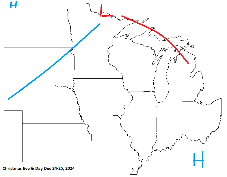
On the Christmas holiday this year, I'm expecting a system moving across the sub bringing in colder wx, with some rn/sn, and LES on the backside on Christmas Day for some.
-
Worked up the last forecasts for the year. On Pearl Harbor Day Dec 7 it looks like fair wx under HP with a system moving in from the W bringing in milder temps, and a threat of rn/sn.

-
An OK call for this day. LP scooting through the Lakes bringing wet wx with HP strengthening over MN. No energy riding the S areas, instead there will be weak trough, and LER across the Lakes. There is a chance for a mix of rain/snow across NE MN Monday am. We quickly warm back up as HP moves SE, and brings a return flow later in the week.


-
A cool, wet weekend on tap. A decent steady rain forecast for tonight into the am. A batch of showers moving through right now. Been dreadfully dry around here. Temps pretty seasonable.
-
Early data for Sept in, and looks like a very warm Sept in the record. Currently sitting at 5th warmest, just a couple hundredths ahead of 1933, so it may or may not hold in the end. It was driven by a very warm 2nd half of the month, especially in the N sub. 5 & 10 yr trend charts shown respectively.
-
SW US vibe.
-
Spit a little rain here. Just enough to wet the surface briefly. Breezy, cool today before warmer wx returns. ZZZZ is spot on. Hoping for a little more action towards mid Oct.
-
Pretty good call here with HP over the region, and cooler, but pleasant conditions.


-
This is what I found for my town TH. Looks like it tied 5th driest month in the record since 1894. Jan 1894/Nov 1904/Dec 1905 0.00" Jan 1981 0.02" Nov 1916/1917/March 1960 0.04" Dec 1913 0.05" Nov 1912/Dec 1979/Sept 2024 0.06"
-
0.06" here TH for the driest Sept on record. Beat 0.26" from 1948. Dry conditions expanding quickly here in NE MN. Duluth had its warmest Sept at 64.3F beating out 1897 (62.6). 2nd driest with 0.31" (0.19" 1952).
-
I think it's something wet from the sky. Wouldn't know, haven't seen any in such a long while
-
Chilly morning with temps running in the upper 20's-mid 30's across the area., with 40's closer to the Lake. Milder temps coming up mid week for a few days. No rain either. 0.06" for the month so far (3.53" Sept avg), and no rain till the end of the month would make this a record for TH. 0.26" in 1948 is the current record.


