
Brian D
-
Posts
2,110 -
Joined
-
Last visited
Content Type
Profiles
Blogs
Forums
American Weather
Media Demo
Store
Gallery
Everything posted by Brian D
-
1-3" across my area. Underperformed big time. NWS DLH issued WS warnings around the Lake shore, and schools here closed. They have a little egg on the face today. I picked up an inch from a lake band that formed later in day that did not stay around for too long. Drier air really cut down on the synoptic precip, and LP tracked too far S.
-
I'll be surprised if we get 4-6" up along the head of the lake. Dry air keeping things at bay. Std radar showing precip aloft, but not making it to the ground as enhanced radar is showing along with my eyes. LP too far W to S. South of the Lake getting in on some good action, tho.
-
Winter Storm watch for the head of the Lake starting at midnight as the clipper starts to affect my area. Lake will contribute with the colder air over the water setting up some bands mixed with the synoptic snows on an E/NE wind. We are on the N edge, so without the Lake, wouldn't see much. Nice to see the sun today. Been cloudy for a few days.

-

Winter 2024-25 Medium/Long Range Discussion
Brian D replied to michsnowfreak's topic in Lakes/Ohio Valley
My son's B-day is Jan 12. He turns 31. You know your getting old when your eldest is 40. -
About a 0.1" of snow yesterday, and now temps just hovering around low-mid 30's. Dense fog adv out for TH, but no fog to be seen, even at the airport. DLH has fog, but all good lakeside there.
-
Not quite as cold across the area this morning. -sd's near the lake to upper -10's to lower -20's in the inland areas. Hibbing -21 (5th), and I-Falls -20 (T 9th). Milder temps on tap with some frz rn/sn possible this weekend. Next week is looking like some lgt/mod snow possibilities.
-
I-Falls -24 (T 7th), Hibbing -20 (5th), Duluth -18 (T 4th), Ashland, WI -12 (T 5th), Brainerd -13 (7th), St. Cloud -11 (T 7th), MSP -8 (T 8th), and Eau Claire, WI -9 (T 6th). Significant cold snap. Will see how tomorrow am ranks.
-
-10's (nearer the Lake) to -20's (interior NE MN) this morning. She's a bitter one. Highs in the sd's today with another bitter am on tap tomorrow before things warm up again. Winds are calm-5 right now, but the day wind will kick in keeping wind chills on the lower side today. Cold wx adv will stay in effect through tomorrow am. Like the new change. Wind chill's are one thing, but temps get just as cold as wind chills, so new adv is a good reflection of overall conditions, wind or not.
-
Early data showing a warm Nov similar to 2020. And Fall ends up as 3rd warmest. 5 & 10 yr trend charts shown respectively.


-
Sorry for the delay, computer went down last week. Decent call here. Milder temps with some mixed precip.

-
Finally back after computer issues. After some good snows across NE MN Sun into Mon, now the bitter wx arrives today for a couple days. Wind chills -20 to -40 anticipated. Cold wx adv issued. Replaces the Wind Chill advisories. Extreme Cold warning will replace Wind Chill warnings.
-
Cold, windy stretch. Temps bottomed out before midnight in the sd's, then started to slowly rise through the night with a small dip at sunrise this morning. Temps in the sd's with windy conditions brought wind chills down to near -20F. Highs around 20F near the Lake today, 15 inland. Yesterdays high of 29 here in town was met at around 8am to a low around 9F 13 hrs later at 9pm. Furnace running quite frequently with the wind.
-
1-3" around the NE MN/N WI area with the Grand Marais/Hovland area up in Cook county seeing 4-7". High wind warning up that way, too, for winds of 50-60 mph possible. Wind advisory out for a good chunk of the W sub today. Bands of CAA snow showers developing this morning as front has just passed through.
-
Snow ended here not long ago. Measured 1.0". A little more winter looking now in town. Winds should kick up in the a.m. n blow it around.
-
Clipper starting to make its presence felt here this morning with flurries. Looks like the biggest snow totals will be to my N to NE with some stout winds tomorrow.

-
Lows in the sd's n teens. Min's hit just after midnight then started to rise as clouds moved in overnight. Looking forward to the clipper moving through Tues. Looks like 1-3". Would get more if the center of LP swung down a little more to get E winds, but more of a WAA with W-SW winds. Time to build snowpack in town. Already 2-4" otg in the higher terrain.
-
Winter 2024-25 Medium/Long Range Discussion
Brian D replied to michsnowfreak's topic in Lakes/Ohio Valley
Looks like the models are trying to work out an active stm pattern as they close in on mid Dec. That's what I'm seeing too. Hopefully I will get in on some good synoptic/lake enhanced snows. -
Cold morning with lows in the single digits +/- around the area. Wind chills between -10 to -20.
-
Gaylord's 24.8" beat the calendar day (midnight-midnight) record of 17.0"(3/9/42). That's a pounding. Lots more to come over the next few days with LES, and a clipper zipping through next week with more LES after that.
-
1-3" of snow across areas of N MN. N WI into Ironwood, MI has seen 1-8" so far. Sault Ste. Marie reporting 23" at a location there. Must've had a band set up over that particular location as other reports there are 8-12". Looks like 8-12" being reported across some locations across the UP MI in general.
-
Cold, with flurries for Thanksgiving. LES setting up across N WI, into the UP MI. Briefly made it into the upper 20's at midday today. Seasonably colder conditions the next couple days with highs in the mid 20's, and lows in the single digits to teens (nearer the Lake).
-
Good forecast for Thanksgiving. Evolution was a little different than anticipated. We have a trough swinging in from the N, and a system in the S areas moving through Wed into early Thurs am. But a blustery, cold Thanksgiving was what I saw as the end result with plenty of LES. Weekend call not good, as LP gets squelched by another area of HP as it moves out of the W into KS over the weekend. HP quicker than I thought. Mid month stm brought good rains, and my call for a cooler Nov busted horribly. Thought early Nov would be more seasonable to cooler with mid month much milder, and a colder end. 2 of 3 isn't bad, but early Nov threw the final call way off. That's OK, as it was nice to have extended mild wx. Probably going to pay for it tho.

-
10-15 away from the Lake, around 20 on the shore this morning. Seasonable wx for a change. So starts winter.
-
Winter 2024-25 Medium/Long Range Discussion
Brian D replied to michsnowfreak's topic in Lakes/Ohio Valley
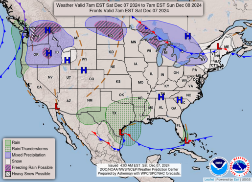
Looking at Dec from my modelling method, I'm going with colder early Dec, but a switch in mid Dec to a milder, wetter pattern (more stm chance my way), before things switch out after the solstice to a colder pattern again. Actually could see an avg to below (possibly well below for some) Dec in the books to end the year for sub as a whole. We shall see. -
Light, wet snow still falling at 10 am with maybe an inch on the grass here in town. 2-3" being reported across the area early this morning. Final totals will be a little bit more.


