
Brian D
-
Posts
2,110 -
Joined
-
Last visited
Content Type
Profiles
Blogs
Forums
American Weather
Media Demo
Store
Gallery
Everything posted by Brian D
-
Ended with 4". Big fail up N. Dry air put the brakes on bigger totals. Lake never really got involved either. Surface to 850 winds just too weak. Anything that may have developed probably stayed out there, and drifted up into CAN with the upper flow from the SW. EDIT: NWS DLH just emailed me back. They don't think dry air was too much, but the wind velocities were too weak to push anything onshore, or any orographic lifting. He did suggest snowboards on buoys. LOL
-
3.5" imby so far this morning. 4-7" being reported at other locales. Still snowing, so should see some bigger totals later today. Nice to see white otg.
-
Pm update showing a slight increase in projected totals. With no dry air inhibiting the snow this time, could end on the higher side. Here's to hoping so. WSW issued for the areas to my N. WWA for the rest of us.


-
About time we get something substantial. But we'll see how it ends. This will be better than that last clipper they overcast (got egg on the face). Last one was "High & Dry" (old Def Leppard). Pressure too high, and air too dry. This one is much better for lower pressure for better lift, and not as much dry air to contend with. Should be a good overnight hit.
-
That light snow stayed really light. About 0.1" as the band fades to the E. Well, here's hoping for a little more this weekend.
-
Low chance that it happens in any given year. I usually have a least a few inches otg by now. Inland still has some crusty snow.
-
Back during the summer I worked up datasets for the 4 major cities of our sub comparing urban to rural. Thought I'd repost those with 2024 added. It was a very warm year.


-
Looks like a quick 0.5-1" of snow this aftrn with a front moving through. Hopefully that weekend clipper will give me a couple more. Any Lake bands would be welcome as winds turn E to NE. Very brown still after the warmer end to Dec, along with the rain we had here in town.
-
Add in the Max & Min monthly precip.

.thumb.gif.f46717208becc78442d01c776e30ac46.gif)

.thumb.gif.1ff41c10b854955e46e15e24c5953641.gif)
-
This will be the Max precip.

.thumb.gif.1c0fd2a7d6c9decd3c14e17f359073c7.gif)

.thumb.gif.a0942de7a8d91e8c5ee7a07c06e79bf4.gif)


-
The last for temps is Min.

.thumb.gif.1987aeadf5f8d51801634c27f3f79f73.gif)

.thumb.gif.34dedabaf4556cc18bd23c381548768c.gif)


.thumb.gif.5afb7d71dee692a45c50fdd82bc5303d.gif)
-
Next is Lmax.

.thumb.gif.1792eaebcb70c6dc011a78b1bb828e00.gif)

.thumb.gif.c6579d7f3d4f1f95041220e193148a35.gif)


.thumb.gif.6c4a2c2b318dfd4aa033672846e62df2.gif)
-
Next is the Hmin metric.

.thumb.gif.048c69f1421252357da3976b9b3e2963.gif)

.thumb.gif.7c7c9796a9fb690fe90b68a60b7acb4b.gif)


.thumb.gif.254153c0a989ba52eae8da5aee1d6fa5.gif)
-
Finished my work up of the extremes from 20 long period (mid 1870's & earlier) stations in our sub region. I'll be posting Max, Hmin, Lmax, Min, and Max precip metrics. I also may add high/low avg metrics, and snowfall in the future. I'll also will be working on those stations that have start data from the late 1870's into the mid 1890's. There are quite a few of those, as well, with most of them having starts in the early 1890's, so I'll probably start the graphs with the 1890's decade with them. And they are not co-op sites. Lets start off with the Max temps. First graph will be the 20 stations combined, followed by the W & E split for the top 5 & #1 and then a list of the most extreme daily temps in the records (you may need to click the image to get a good look). Then followed by the monthly, with the W & E split. The W & E are pretty similar, but you will notice some difference. All data is updated thru 2024.

.thumb.gif.c4aab926909fc8acf2f8946fc4d179a5.gif)

.thumb.gif.8201dbb7017729589d2292569300e0b4.gif)


.thumb.gif.9a9e418e1b7d906386a30771b0083baa.gif)
-
Early data in for Dec. Chalk up another warm one. As for the Annual data, currently running 4th warmest, just a few hundredths behind 1998. Decent chance it slips into 3rd after all datasets have reported. 5 & 10 yr trend charts shown respectively.


-
-10's to -sd's this morning with sd's inland to around 10 on the lakeshore this aftrn. Wind chills away from the lake running -20 to -30. Pretty much the same wx for the next few days. All the action staying S for now, so enjoy it while the potential lasts.
-
Chilly day with temps in the -sd's this morning. Sd's for highs, maybe a 10 in there. Only thing HOT coming is the SuperBowl of the NFC North on Sunday night. Vikings n Lions. What a game that will be. Haven't watch pro ball in years, and this year decided to watch some on the NFL YT channel. Just watch the 10-15 min long highlight vids. And the Vikings are hot this year as has been Green Bay, and the Lions. What a strong division this year. After the Vikings 1998 season with Cunningham, got turned off, until 2009 with Favre. Both big fails in the end, and I just stopped watching all together until this year when I saw that NFL had a YT channel, so thought I'd follow the Vikings, and see how things went for them. Quite shocked, actually. We shall see how this one ends.
-
Considering the colder months tend to have the higher % of cloudy days, it's a crap shoot. Better luck next year.
-
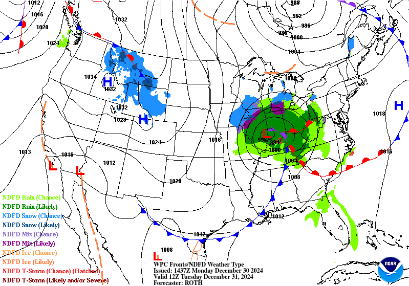
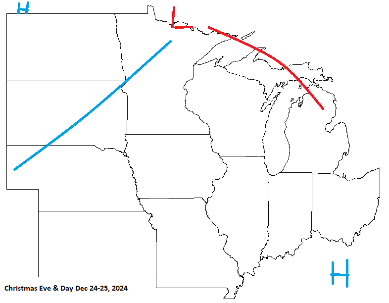
Pretty good call for the end of the year. LP scooting across the S sub on the 31st with HP entering into the picture bringing in colder wx that will kick off some LES. Looks like Dec will end up being near to above avg. Last week of the month very mild.

-
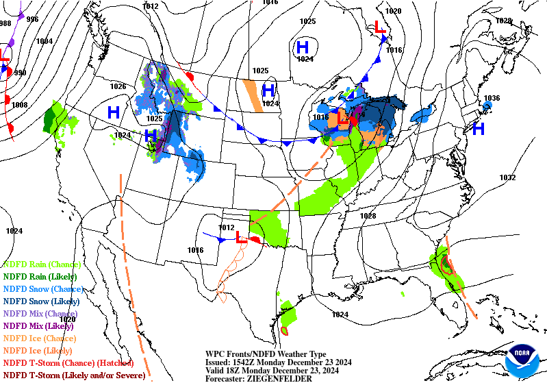
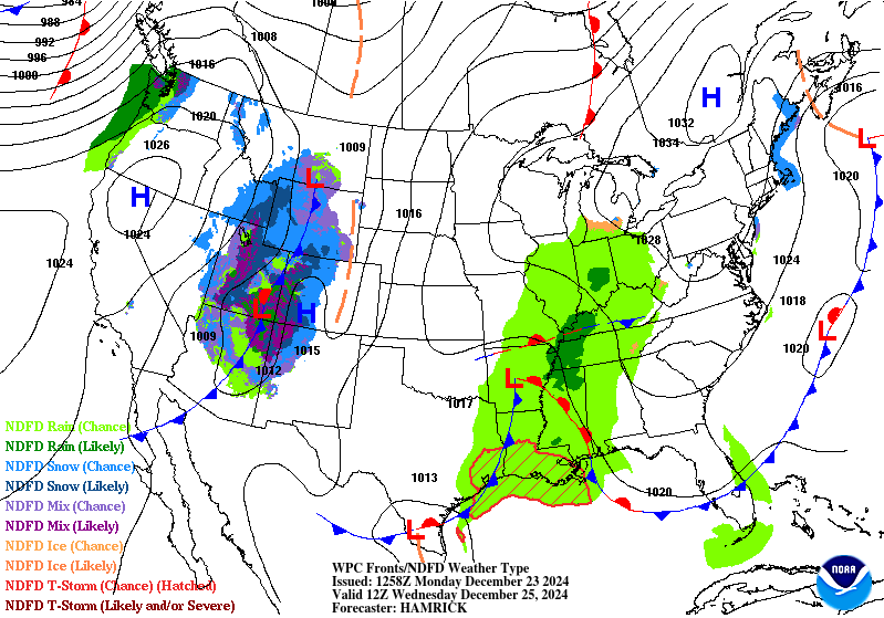
Rain coming to an end thankfully. Up to an inch around the area. Now the slow slide into wintery wx again during the next few days. Barely had a white Christmas in town, and now back to brown. With the upcoming pattern, some vigorous clippers would be nice.
-
Same here. Dreary end of the year.
-
Merry Christmas everyone! Hope you have an awesome day.
-
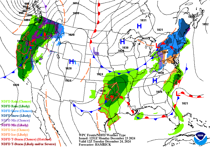
I was slow on this cast. System moves through Mon-Tues, and less cold air behind. Christmas turning out to be a very nice day for most with some rain entering the S sub. May your holiday be a blessed one. Merry Christmas ev1!
-
Very cool mini vortex over the Lake this morning. It has been slowly drifting N as mid level winds are light from the S.

-
NWS DLH put out a story board on their forecast fail today. I'm sure they got some flack from the communities, especially the schools.


.gif.a4d7dae62b2006c671a88eb918508f4f.gif)
.gif.3f6098231beddac3d832913005aa6078.gif)
.gif.69fd3e18db62c6b88a0b8a9ae07d8c1d.gif)
.gif.ebe5e7df41b8a07fad412da7c679e1b6.gif)


.gif.f28cebaef4d8a7a52e73ae9efefa8d2b.gif)
.gif.5bd3690eb4622e01f9c8c9775bc1187d.gif)

.gif.e3d72462f95322e78686a53c34c794b3.gif)
.gif.17d558661776fef4245234e842a167b7.gif)
.gif.2ed018d351ef721e7d87e4a17abac181.gif)

.gif.9c447989bc7435637057c301c518ba0a.gif)
.gif.5011782a3c6a76255c5a771088ae894f.gif)
.gif.05f14498474b1b46811fe97af3b821a8.gif)

.gif.ae22b84978d6a96335ed32f3c5d5cbde.gif)

.gif.0b4a68895af476d856e676b700403bb4.gif)
.gif.f90e8e78faf7db2c318c244fc5d31fd7.gif)

.gif.a0709d58915429d2cc19aac1a9cc5e83.gif)

