
Brian D
-
Posts
2,110 -
Joined
-
Last visited
Content Type
Profiles
Blogs
Forums
American Weather
Media Demo
Store
Gallery
Everything posted by Brian D
-
Ice conditions a little less robust today after a lot of wind, less cold since last week.


-
1" of snow from that batch that moved through yesterday. Just snow showers/flurries today. Milder wx on tap with another clipper potential Tues that should net another 1-3". Feb 2 system seems ingrained in the models. That could put down 6"(more or less) around here. Would be welcome if it pans.
-
Hit some low numbers this morning before temp rise ahead of front in the area. -10's to -20's, with -sd's along the shore. Looks like 1-3" possible in the area today into tomorrow. Will take what I can get in this meager winter so far. Looking forward to seeing some bigger hits in Feb n March.
-
Ice status as of yesterday.


-

Winter 2024-25 Medium/Long Range Discussion
Brian D replied to michsnowfreak's topic in Lakes/Ohio Valley
The way I see Feb is cold start, then stormy, milder with brief cold shots, ending with colder wx extending into early March before a milder, stormy wx continues starting in the Ides of March. -
This storm is very similar to the Valentine's Day winter storm of 1895 Lake Charles, LA 22", Baton Rouge, LA 12.5", Gulfport, MS 6.3", Mobile, AL 6", and Pensacola, FL 3". So it looks like this one will be 2nd or 1st biggest snow depending on final totals at various spots along the Gulf coast.
-
2.3" of snow fell last night imby. Sent report in to NWS as usual. Back to seasonable wx.
-
Unfortunately there really isn't a good longer period record for interior areas of NE MN, but just looking at I-Falls(start 1948 with some earlier years), you can see how often -40's occur. As far as top 10 coldest avg, that wouldn't even be close. I-Falls top 10 are all in the -30's to -40's, so it would probably be the same around the Ely area. I-Falls -41.0 1907-02-04 -40.0 1907-02-05 -40.0 1909-01-05 -55.0 1909-01-06 -54.0 1909-01-07 -40.0 1909-01-09 -50.0 1909-01-11 -44.0 1909-01-12 -45.0 1909-01-15 -40.0 1909-01-30 -48.0 1909-02-08 -44.0 1909-02-14 -43.0 1909-02-15 -41.0 1912-01-07 -41.0 1912-01-11 -40.0 1912-01-12 -40.0 1914-02-12 -41.0 1916-01-13 -40.0 1917-12-28 -40.0 1950-01-18 -40.0 1950-01-30 -41.0 1951-01-29 -40.0 1954-01-17 -41.0 1954-01-21 -41.0 1955-12-19 -40.0 1962-01-17 -40.0 1963-01-19 -42.0 1965-01-14 -40.0 1966-01-11 -40.0 1966-01-24 -43.0 1966-01-28 -44.0 1966-02-18 -43.0 1966-02-19 -44.0 1966-02-20 -46.0 1968-01-06 -42.0 1972-01-14 -45.0 1972-01-15 -40.0 1972-01-26 -41.0 1973-01-07 -42.0 1973-02-16 -40.0 1977-01-09 -44.0 1979-01-16 -41.0 1982-01-16 -45.0 1982-01-17 -40.0 1982-02-03 -40.0 1983-12-19 -40.0 1983-12-20 -40.0 1985-02-01 -42.0 1996-01-20 -41.0 1996-01-26 -43.0 1996-02-01 -45.0 1996-02-02 -42.0 1997-01-26 -44.0 2005-01-17 -40.0 2008-02-11 -42.0 2009-01-13 -42.0 2009-01-14 -41.0 2009-01-16 -41.0 2011-01-20 -46.0 2011-01-21 -43.0 2014-01-02 -46.0 2019-01-27 -40.0 2019-01-30 -45.0 2019-01-31 -42.0 2021-02-13 -42.0 2022-02-03 -42.0 2022-02-13 -40.0 2022-02-24 -40.0 2022-02-25
-
Here's the old & new charts. The worst wind chills I've experienced were in the -80 to -100 range on the old chart. There was a day (in the am) when we had upper -20's with winds up to 40+ back in the 80's. That was wicked!


-
Notable cold this am across the region. Top 5 - Hibbing -35 (T1st), St. Cloud -27 (T5th), Ashland, WI -24 (T4th), Rhinelander, WI -27 (3rd), Eau Claire, WI -24 (4th). Temps rising today on S/SW wind. Looking for 1-2" of snow tonight. Hit -23(5th) here in town for the coldest am of this cold blast. Just as a side note, yesterday's coldest temp up here was -42 at Seagull Lake up on the CAN border. Yesterdays(Jan 20) Min/Low max/Low Avg I-Falls -34(7th)/-18(1st)/-26(1st) Hibbing -30(T5th)/-16(2nd)/-23(T3rd) Duluth -24(T5th)/-12(T3rd)/-18(T5th) Park Rapids -31(T6th)/-18(1st)/-24.5(2nd) Brainerd -26(T7th)/-12(2nd)/-19(5th) St. Cloud -23(T5th)/-9(3rd)/-16(T4th) Minneapolis -18(T7th)/-6(6th)/-12(T6th) Ashland, WI -19(6th)/-6(3rd)/-12.5(5th) Rhinelander, WI -24(6th)/-5(3rd)/-14.5(2nd) Eau Claire, WI -19(8th)/-7(2nd)/-13(T3rd)
-
Significant low max's yesterday. I-Falls -12 (4th), Hibbing -10 (T2nd), Duluth -8 (T4th), Brainerd -7 (3rd), Park Rapids -10 (T4th), Ashland, WI -3 (2nd), Eau Claire, WI -4 (T3rd).
-
Currently have 2 -39's on the board in NE MN. One in Tower, and the other at Ash Lake. Low max records could fall today with highs in the mid-upper -10's inland. Low of -19 here in town with overcast along the shoreline again from the Lake steam.
-
Looks like highs today were able to stay below zero, even along the shore. -sd's with lower -10's up N. -15 for a high at the Cook County arpt N of Grand Marais, and a -14 near Voyager's National Park, and Fernberg look to be the coldest in NE MN. All up near the CAN border.
-
Decent forecast here. Bitter wx along with LES. Trough will be swinging through. I was a little quick in bringing in LP from the W tho, as that starts showing up later on Tues the 21st.
-
It got another 1-2 deg colder than that. The lowest temp I've found across my area is -29 around the Ash Lake area SE of I-Falls. Wind chills are in the -30's with some -40's. -17 here in town with 5-10 mph winds this morning, so wind chills are not a big factor. The lake steam is rising ,and spreading aloft over the shore. Overcast sky here. Ice will form fast under lighter winds. Over the next week will be interesting to see how much ice forms. Honestly, just can't wait for some winter storms. Been bleak so far this season. It's a shame when the Gulf coast does better than here. LOL
-
Ancient Chinese secret.
-
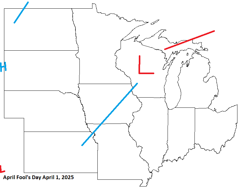
On April Fool's Day, I'm anticipating a system moving through the Lakes, and possible snow up my way. Another typical Spring storm potential.
-
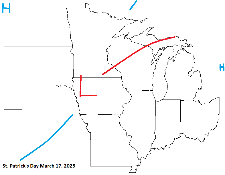
On St Patrick's day this year, it's looking stormy. Typical March system. The second half of March looks like good storm potential into the early days of April.
-
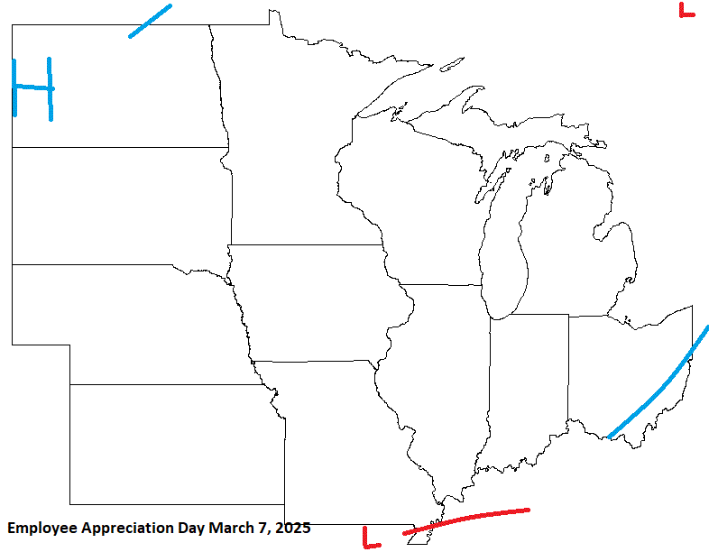
Next is Employee Appreciation Day on March 7. Looks like rather chilly wx for early March. Watch for possible energy affecting the S sub. Any LES will be subject to ice conditions, which could be robust. We'll see.
-
Extreme cold warning in effect starting later this evening thru Tues am. Wind chills down to -45 or so on NW winds. Midnight high of 16 with temps hovering around 0-5 for the aftrn high here in town before the drop continues. Inland areas should stay just below zero for the aftrn.
-
The last pleasant day for a few days. Going to be a brutal shot, but at least it doesn't last for a whole week. 1-3 day shots are not too bad. Still tough tho.
-
Looking at Duluth arpt siting data HOMR, it looks like snow is reported from the NWS office which is about a mile WSW of the arpt. I do know they put up a request for I-Falls arpt this past summer for a snow measuring contractor. MSP arpt has had their Met crew taking measurements since 2020. Prior to that, it looks like they've had a contractor on/around the aprt. As for T snow depth, DLH does report that as seen in their F-6 form, as well as I-Falls, and MSP along with others in the area that take snow readings. (Not co-ops tho)
-
Kick in the shorts come Sun n Mon. Highs in the -10's with -20 to -30 lows. Might even get a little colder at sunrise if winds are dead calm. Shoreline will be -sd's for highs with -10's in the am. Just for perspective, record lows are in the -40's, and low max in the mid/upper -10's for interior NE MN this time of year. Although I-Falls does have a -28 high on the 19th (this Sun), second only to -29 earlier in the month. Sure we won't get that bad.

-
Ice formation as of Jan 12. And with the current pattern through the month, this should fill in nicely. We could be looking at a high ice year.
-
-10's inland to -sd's along the shore this morning. Wind chills in the -30's away from the Lake. Looking, and feeling like winter now.


