
Brian D
-
Posts
1,936 -
Joined
-
Last visited
Content Type
Profiles
Blogs
Forums
American Weather
Media Demo
Store
Gallery
Posts posted by Brian D
-
-
On 1/2/2024 at 1:51 PM, Brian D said:
President's Day forecast looks interesting for the S areas. Hope it pans.

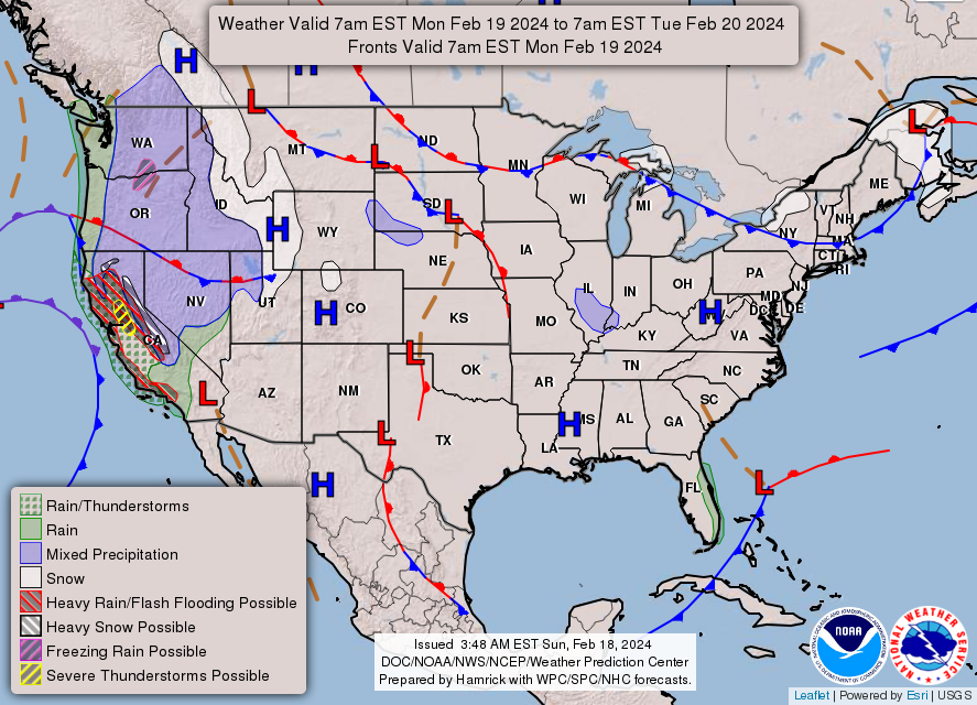
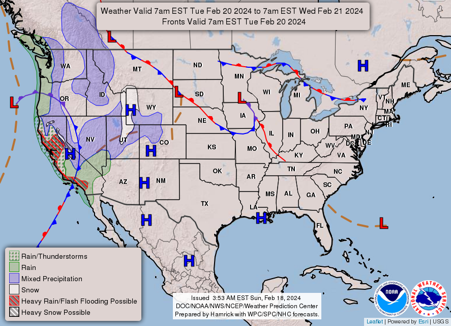
So-so cast here. HP over CA, but southern LP was much further S along the Gulf. Boundary to the W. Looks like some energy moving into the region on the 20th with little fanfare before a stronger LP moves in around the 22nd as a rain maker in the S areas.
-
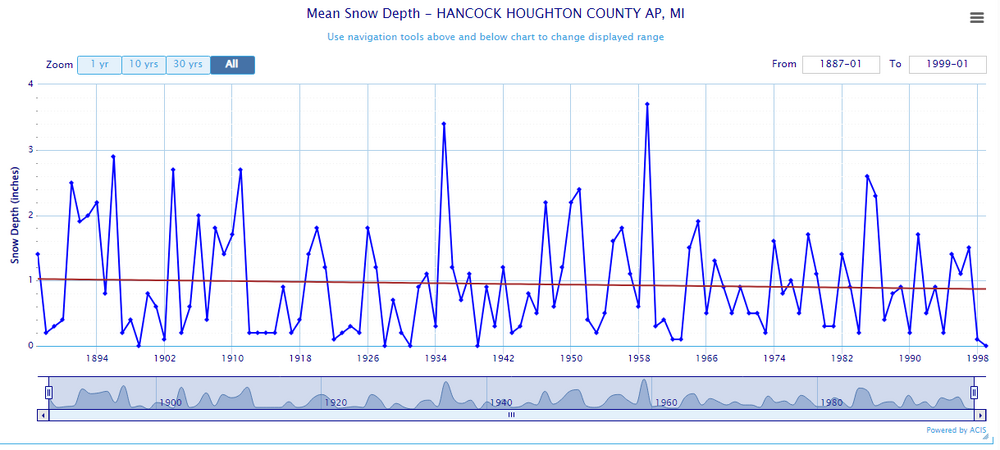
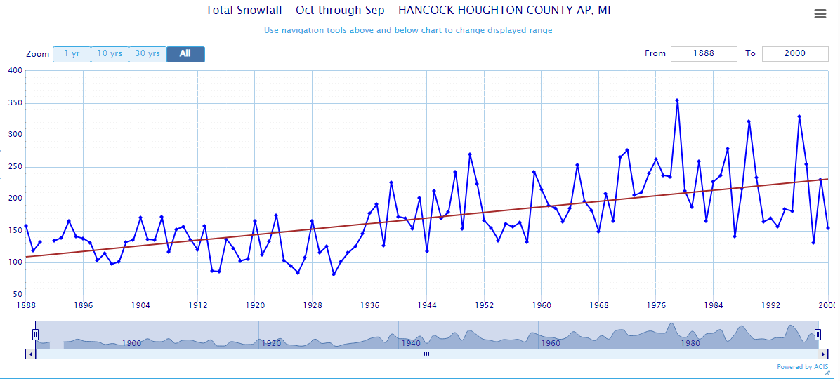
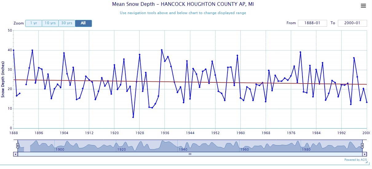
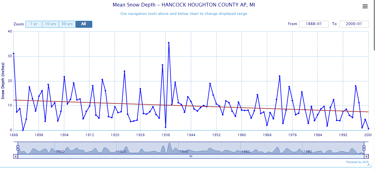
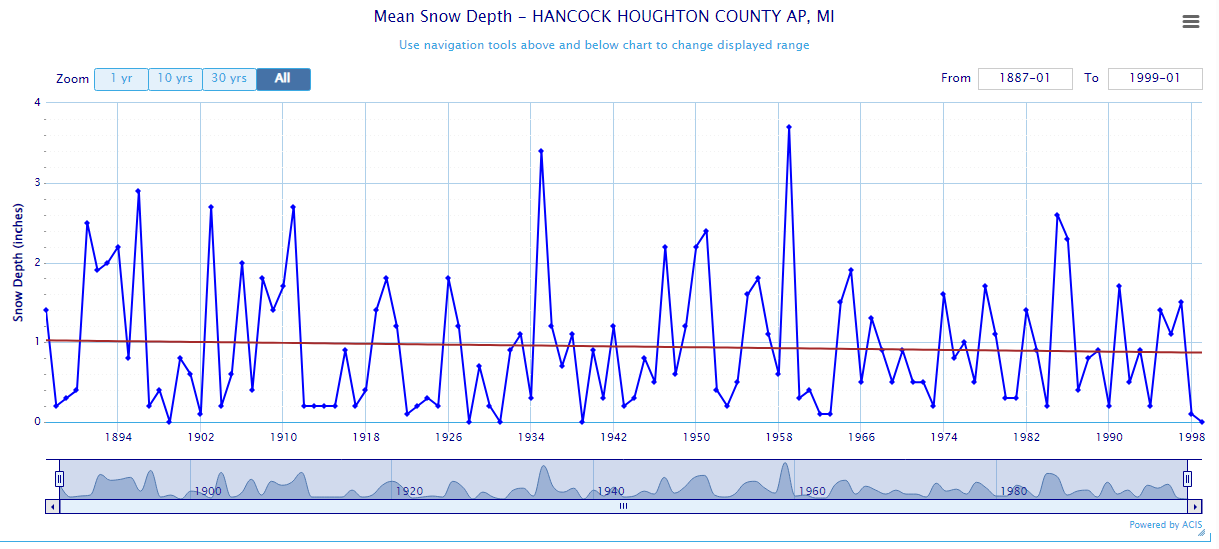
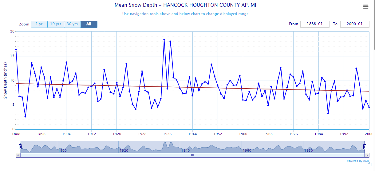
1 hour ago, TheClimateChanger said:
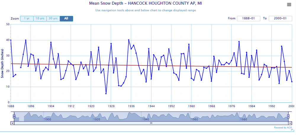
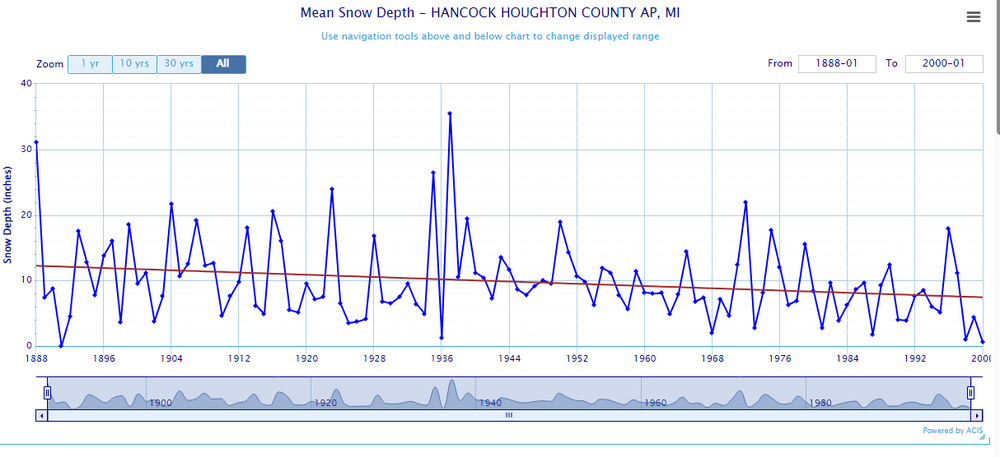
I mean this is a little suspect, no? Ends in 2000, but you get the point... snow depth trend would probably be more pronounced if there were still observations at the airport. Somehow snow depth was higher 100+ years ago, despite snowfall being 50% of recent decades.


If average seasonal snowfall doubled, why has mean snow depth decreased if every season? Certainly, the temperatures have warmed somewhat, but it's still mainly below freezing in Keweenaw.
Mean Snow Depth (Winter)
Mean Snow Depth (Spring)
Mean Snow Depth (Fall)
Mean Snow Depth (Annual)
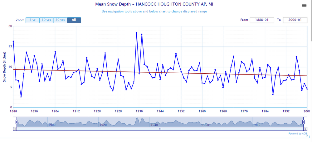
You need SWE data along with that analysis. That would be helpful, but don't think there's any early data with that metric. If there is, take a look at that. Early data also tends to have more missing data, as well.
Oh, and that stn is also threaded. Actual proximity to the lakeshore, and elevation in it's history is a big player.
-
 1
1
-
-
On 2/12/2024 at 9:20 AM, OrdIowPitMsp said:
Personally it really doesn’t matter a whole lot right now how big of a train wreck this winter turns out to be.
My wife and I welcomed our 2nd child into the world last week. Cloud 9 only begins to describe how I feel. You can’t change the weather but you can impact and shape the little creatures you create in life.

Awesome man! Yeah, bringing new ones in is soo cool. Cherish every moment, even when they get older, and a bit naughty, and think they know everything. LOL You never know what the future brings. Losing my youngest was/is the toughest thing I've ever gone through. May you, and your family be greatly blessed!
-
 2
2
-
-
13 minutes ago, michsnowfreak said:
I fully expect a hot summer this year in a nino to nina transition. As Ive said before, by far the season that has warmed most here has been summer (esp mins), so I doubt the absence of 90F-heat will grace us 2 years in a row.
90F+ days (avg is 13) in summers preceding Modoki Ninas
1973– 9 days
1975– 4 days
1983– 21 days
1988– 39 days (most on record)
1998– 10 days
2000– 1 day
2008– 7 days
2010– 17 days
2016– 23 days***
Nino to Nina transition years
1954- 17 days
1964- 26 days
1973- 9 days
1988- 39 days
1998- 10 days
2010- 17 days
2016- 23 days
Just looking ahead, July will be the month to watch this summer. If the pattern I see pans, a hot, dry stretch is in the offing in mid July. Expecting 100's. We shall see.
")
-
1
-
-
Add 23 Nov too as a warm day
1905 - 55
1820/2001/06/21 - 54
1907/98/2009/11 - 52
1902/2014 - 51
1908 - 50
-
1
-
-
2 hours ago, michsnowfreak said:
Thanks!!!
Just looking at April 1820, it was very warm on some of the days. These are 1400 hr readings. It would be so nice to have daily data going back centuries. I bet we would be amazed at some of the readings from way back then.
April 10
1977 - 88
1910 - 81
1820/2006 - 79
1955 - 78
1930/2011 - 76
April 19
1985 - 87
1987 - 84
1923 - 83
1820/1915 - 82
1908 - 81
April 23
1990 - 86
2009 - 85
1820 - 84
1925 - 82
1942 - 81
April 24
1820 -85
1962 - 84
1939 - 83
1921/42/90 - 81
1915 - 80
-
2
-
-
On 1/2/2024 at 1:49 PM, Brian D said:
Valentine's Day forecast looking interesting. Storm watch around mid-Feb.

Decent call here. Not a big storm, but an aggressive little low moving through along the frontal boundary. Take what you can get!
-
1
-
-
12 hours ago, michsnowfreak said:
One of the 1850s winters was extremely mild, I think 1857-58?
What I can glean from Ft Snelling written notes, Dec 1857 was mild, and Jan 1858 was too, but Feb turned cold. My monthly data charts confirm this.
-
16 hours ago, TheClimateChanger said:
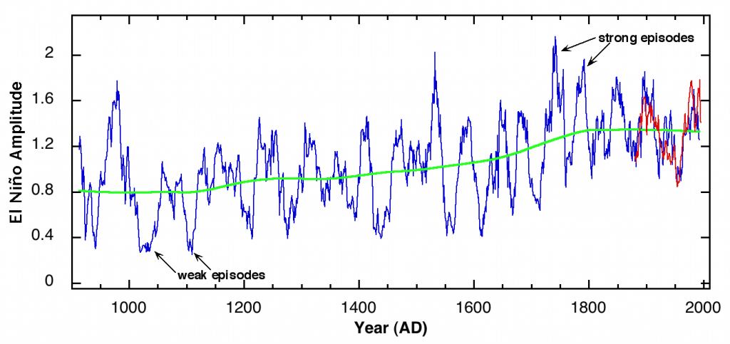
Well, 1877-78 was always considered to be the warmest of record by far, including the pioneer era records at Fort Snelling dating back to 1820. So when there's more than 200 years of data, and it's beating the record by nearly 3F, I think 1 in 1000 is a reasonable estimate for a recurrence interval, no?
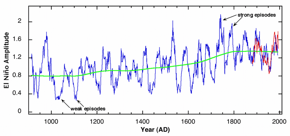
There's a possibility that the W sub experienced similar conditions back in the 1700's. Tree ring reconstruction of ENSO shows this. Data would be very nice, but it's all we have. And of course, other teleconnections need to be in play, as well, to get what we have now.
I've had this chart for a few years. Sorry, don't remember where I saved it from. Not a big fan of tree ring data, but it can be useful sometimes.
-
For some who have, or may wish to ever come skiing up along the North Shore, sad news. Lutsen's main lodge burned down last week. It was built in the 40's, and was a replacement from a fire back then, too. Lutsen's history is well over 100 years (since the late 1800's I believe). Just read it in our free local paper. I don't use social media, so I'm sure others knew long before I did. Fire Marshall is investigating, so at some point, should know what caused it. Not that skiing, or any winter sports is enjoying a good year this year. They will rebuild, but that will take time. How it will affect their operations in general. not sure, especially for next season.
-
 1
1
-
-
0.25" of rain, then 0.2" of snow the last couple days. Temps running seasonably warm with what looks to be more avg temps by next weekend. Very nice wx.
-
Nice looking meso low moving through S MN with a band of rain, and maybe thunder. Looks like its heading in my direction.
-
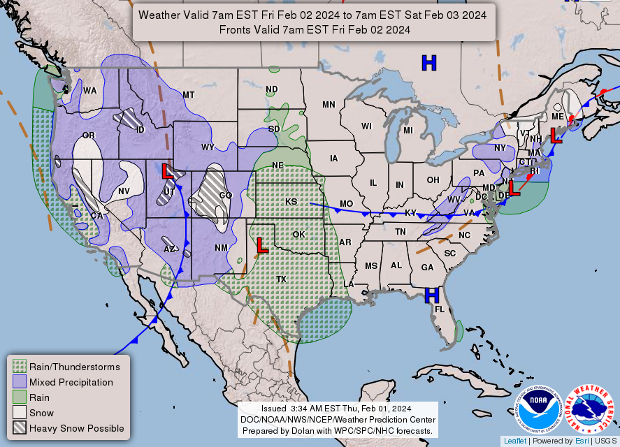
4 hours ago, TheClimateChanger said:
Unbelievable SCORCHING start to the month. The average high at MSP has been more than 4F above any other year over this same 7-day period, and DSM has been nearly 2F above any prior year. Chicago has its warmest first 7 days of February since 1882! Expect eastern sections to climb over the next few days. Many places could see their warmest first 10 days of February on record by average high temperature.
Here are some rankings for average high temperature over the first 7 days of February:
Minneapolis/St. Paul (1st)
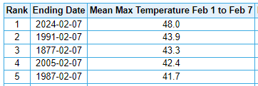
Chicago (2nd)
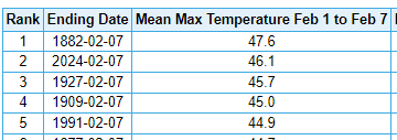
Green Bay (2nd)
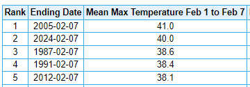
Des Moines (1st)
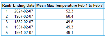
Indianapolis (5th)
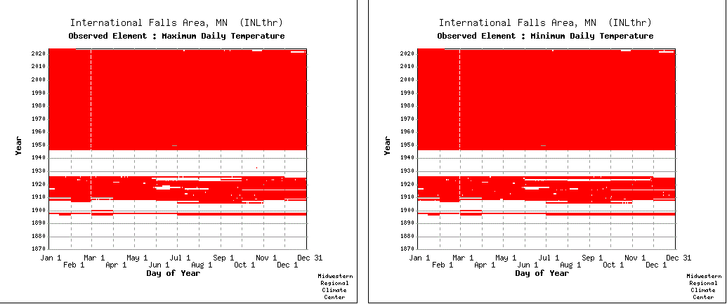
International Falls (2nd)
LaCrosse, WI (1st)
Milwaukee (5th)
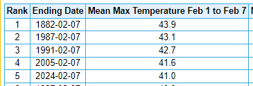
Toledo, OH (5th)
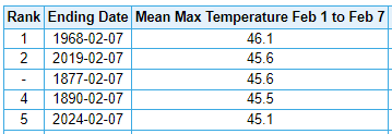
Detroit (7th)
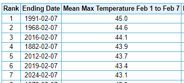
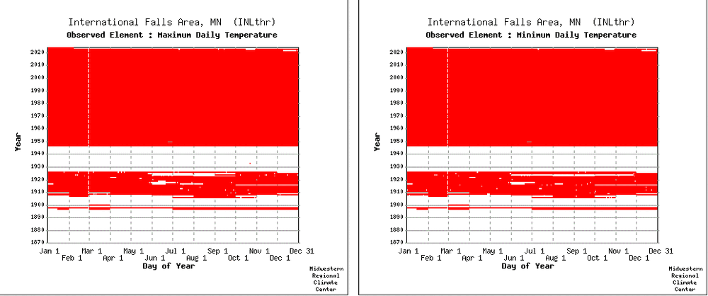
I-Falls record isn't that good. Pretty short. I looked at this and was rather bummed to see how much data is missing prior to 1948.
-
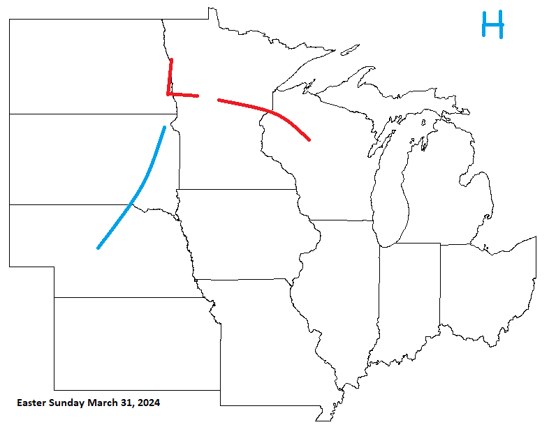
For Easter this year, I'm expecting a system to be moving through our region on that holiday weekend. A mild start turning wet & stormy, even into April Fools day.
-
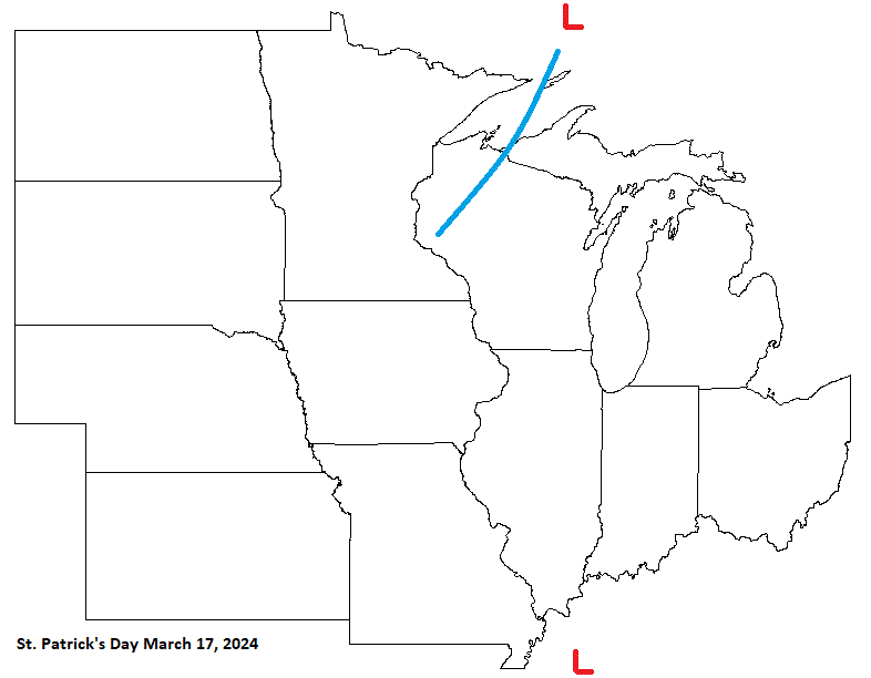
My forecast for St. Patty's day this year looks like CA system moving through the N with potential energy affecting the S sub.
-
A bit of rain in the offing starting later today with some light snow on the back side. Looks like 0.25-0.50" expected. Take what we can get. Precip needed no matter rn or sn. Then temps cool down to seasonably mild conditions. Been a warm start to the month. Very mellow wx wise.
-
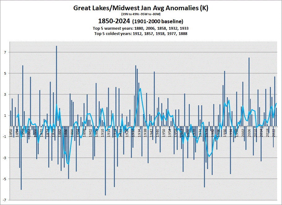
Prelim data in, and a warmer Jan driven by the stronger anoms in the N sub is in the books. 5 & 10 yr trend charts shown respectively.
-
1
-
-
On 11/19/2023 at 2:09 PM, Brian D said:
GHD looks like high pressure moving in bringing some rather chilly wx. LES probable, as waters should be pretty open still.

So-so call. The HP swung down a little E of where I expected, so not much for colder air because of that. Had some light LES myself today Feb 1. And others may experience some light stuff as well.
-
Snow showers off the lake this aftrn. Adding a little garnish to the patchy snow otg. Temps spiked from 32 to 45 this am before dropping back to 34 currently. Trying to be winter
-
23 hours ago, Brian D said:
Very mild day today with temps cast for mid 40's. Running in the low 40's atm as we are coming into peak for the day. A very mellow few days. Looks like the Dec-Jan avg is going to come in at a solid 2nd behind 1877/78 in Duluth. That sure was a warm stretch back then up my way. Too bad there weren't more stns having data from that time here across the N MN, or at least accessible. I'm sure there was some spotty data at some other sites around that time. Listing Marquette, MI at solid 3rd and Minneapolis, MN, edging 1877/78 for 1st. Strong daily avg today will bump it up a little more. An impressive winter so far. And it looks like Feb 1878 was extremely mild as well, so we shall see how it goes for Feb 2024, and what the final tally is for this winter season.
Duluth, MN
1877-1878 - 26.6
*2023-2024 - 23.3
1888-1889 - 22.2
1931-1932 - 22.1
1890-1891 - 21.5
Marquette, MI
1877-1878 - 29.9
1931-1932 - 29.5
*2023-2024 - 28.4
2001-2002 - 27.9
2015-2016 - 27.3
Minneapolis, MN
*2023-2024 - 28.0
1877-1878 - 27.8
2001-2002 - 26.1
1913-1914 - 25.9
2011-2012 - 25.5
Duluth ended at 23.6. Minneapolis at 28.2. Marquette data is still missing for the last 2 days and should end up around 28.6/7 for Dec-Jan. Interesting that Dec 1877 was extremely warm, and Jan 1878 was a little cooler. Mirrors this winter so far.
Here in Two Harbors Dec-Jan avg is tied 3rd since 1894.
1931-1932 - 25.9
2001-2002 - 25.6
*2023-2024 - 25.5
2005-2006 - 25.5
1997-1998 - 25.2
1913-1914 - 24.8
-
Record in I-Falls of 53 (45 1999) as mentioned above as well as Hibbing at 50 (46 2009) with records starting in 1938. Most stns have records in the low 50's starting in mid-Jan. Most late Jan records tho in NE MN are still in the mid-upper 40's. In fact, mid Jan - mid Feb is mainly mid-upper 40's with a few 50's in the mix. The I-Falls record of 53 would be the new monthly record (49 1/20/1921), and 2 days earlier than the 55 (1991) on Feb 2nd making it the earliest 50 reading there since 1948 (along with a spattering of earlier records)
-
1
-
-
5 hours ago, michsnowfreak said:
While that very well may be the case (high grass), there was documentation of dandelions in bloom throughout lower MI in January. This years warm December was following an average November which ended with a cold snap, and was followed by a big cold snap in January. At the time of that picture (mid-Jan 1932), there had been almost no cold to speak of that winter. To this day, Nov 1931 stands as the warmest on record, Dec 1931 the 9th warmest, and Jan 1932 the warmest. There was also a lot of rain the entire time.
Just looking at daily records, there were some rather mild days in there. Can see how foliage could quickly sprout. Happens when you get a false Spring, and buds come out, then get damaged from cold. Before that pic was taken, looks like a 4 day warm spell. Temps overall look pretty decent. Nothing too cold.
12/1/1931 0 0 37 30 12/2/1931 0 0 41 27 12/3/1931 0 0 48 29 12/4/1931 0.54 0 41 33 12/5/1931 T T 34 26 12/6/1931 T T 36 32 12/7/1931 T T 36 20 12/8/1931 0 0 32 19 12/9/1931 0.55 1 39 32 12/10/1931 T 0 42 34 12/11/1931 0.12 0 62 42 12/12/1931 0 0 47 35 12/13/1931 0.05 0 41 36 12/14/1931 0.21 0.3 42 30 12/15/1931 0 0 38 30 12/16/1931 0 0 46 29 12/17/1931 0 0 49 33 12/18/1931 0 0 46 29 12/19/1931 0.02 0 52 35 12/20/1931 0 0 46 35 12/21/1931 0.16 0 49 38 12/22/1931 0.67 0 52 45 12/23/1931 0 0 50 44 12/24/1931 0.01 0 57 37 12/25/1931 0 0 37 23 12/26/1931 0 0 35 22 12/27/1931 0 0 38 29 12/28/1931 0 0 45 36 12/29/1931 0 0 40 32 12/30/1931 0 0 35 30 12/31/1931 0.33 0 34 27 1/1/1932 1.41 0 40 33 1/2/1932 0.03 0 40 34 1/3/1932 T 0 38 34 1/4/1932 0 0 38 28 1/5/1932 0.4 0 44 35 1/6/1932 0.2 0 52 31 1/7/1932 0 0 38 31 1/8/1932 0 0 41 31 1/9/1932 0.01 0.1 32 30 1/10/1932 0.04 0.4 33 26 1/11/1932 0 0 35 29 1/12/1932 0.54 0 53 35 1/13/1932 0.11 0 56 50 1/14/1932 T 0 55 44 1/15/1932 0.61 0 59 36 1/16/1932 0.11 0.2 37 32 1/17/1932 0.3 0 50 37 1/18/1932 T T 38 31 1/19/1932 0 T 37 26 1/20/1932 0 0 43 36 1/21/1932 0.37 0 47 37 1/22/1932 0 0 48 37 1/23/1932 0.32 0 40 35 1/24/1932 0 0 35 24 1/25/1932 0 0 43 27 1/26/1932 0.49 0.2 39 32 1/27/1932 0.08 0 41 32 1/28/1932 0 0 41 29 1/29/1932 0 0 52 35 1/30/1932 T T 35 15 1/31/1932 T T 19 6 Sum: 7.68 2.2 Count: 62 62 62 62 Average: 0.12 0 42.4 31.6 Median: T 0 41 32 Low Value: 0 0 19 6 High Value: 1.41 1 62 50 -
1
-
-
Very mild day today with temps cast for mid 40's. Running in the low 40's atm as we are coming into peak for the day. A very mellow few days. Looks like the Dec-Jan avg is going to come in at a solid 2nd behind 1877/78 in Duluth. That sure was a warm stretch back then up my way. Too bad there weren't more stns having data from that time here across the N MN, or at least accessible. I'm sure there was some spotty data at some other sites around that time. Listing Marquette, MI at solid 3rd and Minneapolis, MN, edging 1877/78 for 1st. Strong daily avg today will bump it up a little more. An impressive winter so far. And it looks like Feb 1878 was extremely mild as well, so we shall see how it goes for Feb 2024, and what the final tally is for this winter season.
Duluth, MN
1877-1878 - 26.6
*2023-2024 - 23.3
1888-1889 - 22.2
1931-1932 - 22.1
1890-1891 - 21.5
Marquette, MI
1877-1878 - 29.9
1931-1932 - 29.5
*2023-2024 - 28.4
2001-2002 - 27.9
2015-2016 - 27.3
Minneapolis, MN
*2023-2024 - 28.0
1877-1878 - 27.8
2001-2002 - 26.1
1913-1914 - 25.9
2011-2012 - 25.5
-
0.8" fell throughout the early am-early pm today. Mellow, mild wx on tap for the rest of the week. Don't mind a bit, but would like to see a good ol' fashioned blizzard at some point.

February 2024 General Discussion
in Lakes/Ohio Valley
Posted
Birds flying around, dry leaves blowing around in mid Feb. Love it! Glad to have experienced such a mild winter that's so similar to 1877/78.
Looking ahead, I see GFS wants to spin up a storm around leap day. My modelling suggests LP in the region around that time. There is potential. A little winter would be nice to see as well.