Brian D
-
Posts
2,144 -
Joined
-
Last visited
Content Type
Profiles
Blogs
Forums
American Weather
Media Demo
Store
Gallery
Everything posted by Brian D
-
Showers around the area this morning. Much needed precip through tomorrow. Might see some flakes mixing in late tomorrow as system exits.
-
The precip trend for the 2nd half of April looks decent for MN. Hope that works out. Precip is a fickle beast.
-
Most data in for March, and another warm one in the books similar to last year. 5 & 10 yr trend charts shown respectively.
-
A snowy aftrn yesterday, but nothing stuck. A little on the grass this morning with a mix falling. Temps hitting mid-upper 50's(60?) this weekend with some rain moving in (ending with a mix), then back into the 40's next week. Will be nice when the sustained warmer wx settles in next month.
-
I reported a stm total of 8" here in town. Good snow. Best event total of the year for me. Should be some 12" readings inland as the am progresses. Update: Looks like 6-15" is the range being reported this morning.
-
Heavy bands finally moved through. Looks like SN/-SN for the rest of the system. +SN with the wind was very cool. Seen much worse tho.
-
Blizzard warning issued for the North Shore. Snowing hard, and the winds have picked up some. Vis is running 1 1/2-2 blocks.
-
About 3" of very wet, compact snow. Winter wonderland, for a few days anyway.
-
Lake banding forming, and I'm catching some of that. Snowing pretty good now. EDIT: Dark green on radar. She's snowing good now. 3 blocks vis. Liking this.
-
Measured 1.5" at 630 this morning. Basically been having a very wet light snow (white rain) until about 900 when it went from -sn to sn. Still some wet stuff, tho. Temp at 32 with ENE winds 10-25. Ugly day out there, but nice to see precip.
-
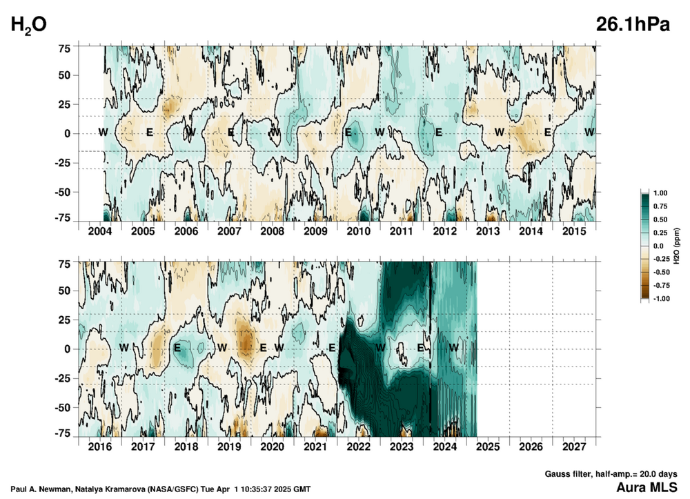
Took a peek at this chart today. Thought we'd being drying out a little more in the upper atmosphere, but it's still hanging on. Still affecting our wx down here.
-
Looks like there settling on this range. Hope it pans, as we really need a good dump of precip, and snow is the best, as it melts into the ground slowly. No frost, so runoff at a minimum.

-
Looking good so far.
-
Good call, just a little ahead of myself in timing as the system will be pushing through on the 2nd.
-
Snow missed here with only ~ 1/2" blowing around with Lake winds 10-25 mph. Scattered stuff around the area right now. Might pick up an inch at the end of this one. Wed could be a big hit of 12"+. Looking at the biggest winter stm of the year, possibly, here in town. Biggest one has been 7.1" from back on GHD (Feb 2). I've recorded 27.6" for the season so far, so the upcoming stm would be a good boost.
-
Well, we had rain with some thunder along with 0.1-0.25 ice in various parts of NE MN and our 1st svr warned stm of the year, too, for hail. Then, as things wound down late last night, we got a nice little garnish of snow. If we would have gotten a tornado, then a kitchen sink may have fallen in there too. LOL! Starting tonight into tomorrow, could get a couple inches. Wed is looking pretty good, so far, for a decent hit of snow (possible 6"+)
-
Rain moving in with a band of snow across the N areas of the region. Temps are running low 30's inland to mid 30's on the shore. They could see some icing in the inland areas. Windy off the Lake gusting up to 25-30. Looks like the next round will be snow this weekend, but I might be on the N extent. South Shore should do well, and DLH.
-
WSWch out for tomorrow. Looks like 1/4" of ice possible here along the North Shore, especially inland areas. Some snow along border as it switches over up there Fri night. 3-6" of snow possible late Sat into Sun with the 2nd LP moving into the region. Rain or snow, but NO ICE, please. In March 2010, we had an ice storm that left 1-2" of ice along the North Shore inland areas, and it decimated the woods. Doesn't look like we will come even close to that, but ice is never good.
-
Very nice day today. Low 50's with a cumulus sky. Come Friday, tho, looks like rn/frz rn over to some snow on Sat. GFS keeps flipping me from hvy sn to mix. Other models keeping a mix, which seems more reasonable. If there was a bit more ice on the Lake, then I would have a chance at all snow. Border areas may get a decent hit, tho. Come late Sat into Sun, that 2nd low might turn out pretty good.
-
Parent's day in late July looks pretty good with scattered stms. Again, could be pretty warm, even hot for some.
-
Come July 4, looking at a CAN front affecting the N areas, and it looks pretty nice, and could be rather warm (hot) for some.
-
Juneteenth this year, believe it or not, I gave a forecast for that 4 yrs ago to a troll. Here's my cast for that day. Generally fair with a CAN front pushing in during the day. (I rechecked, and I'm staying with it)
-
On Father's Day, I'm expecting a front moving into the W sub with fair wx in the E areas.
-
D-Day on June 6th is looking like a system entering the sub with shwrs/stms.
-
For Memorial Day this year, I'm expecting a wet end to the holiday weekend. Should start off pretty decent, tho.