csnavywx
-
Posts
5,730 -
Joined
-
Last visited
Content Type
Profiles
Blogs
Forums
American Weather
Media Demo
Store
Gallery
Everything posted by csnavywx
-

Southern MD / Lower Eastern Shore weather discussion
csnavywx replied to AnEndlessMaze's topic in Mid Atlantic
All snow here. About 3 hours ahead of schedule. Usually a decent sign. -
Southern MD / Lower Eastern Shore weather discussion
csnavywx replied to AnEndlessMaze's topic in Mid Atlantic
For you, should be cranking into the overnight. Will be occasional breaks/lulls as the precip starts taking on a more convective nature and you do lose some saturation in the DGZ as the low pulls in super close to shore -- but there could be a few rumbles of thunder later this afternoon and evening too. -
Southern MD / Lower Eastern Shore weather discussion
csnavywx replied to AnEndlessMaze's topic in Mid Atlantic
Flipping from light rain to light snow here already. -
Southern MD / Lower Eastern Shore weather discussion
csnavywx replied to AnEndlessMaze's topic in Mid Atlantic
That's early! Good news there. -
If you're near or within ~50km to the left/west of the developing 700mb front, BL and ground temps are just not going to be an issue. 2"/hr doesn't care.
-
Southern MD / Lower Eastern Shore weather discussion
csnavywx replied to AnEndlessMaze's topic in Mid Atlantic
That 18Z NAM run is an all-timer. Bonus is that it's 18-24hr out. Gonna be cranking up the BUFKIT profiles for this one and posting em for everyone here when it posts to PSU. -
Southern MD / Lower Eastern Shore weather discussion
csnavywx replied to AnEndlessMaze's topic in Mid Atlantic
We gotta pump that post:snow ratio back up in here. -
Southern MD / Lower Eastern Shore weather discussion
csnavywx replied to AnEndlessMaze's topic in Mid Atlantic
Better/earlier phase and better tilt with the new Euro. Note how the 500mb low closes off earlier. Delmarva nuke time:
-
Southern MD / Lower Eastern Shore weather discussion
csnavywx replied to AnEndlessMaze's topic in Mid Atlantic
Looks like the real McCoy to me for you folks on the Eastern Shore: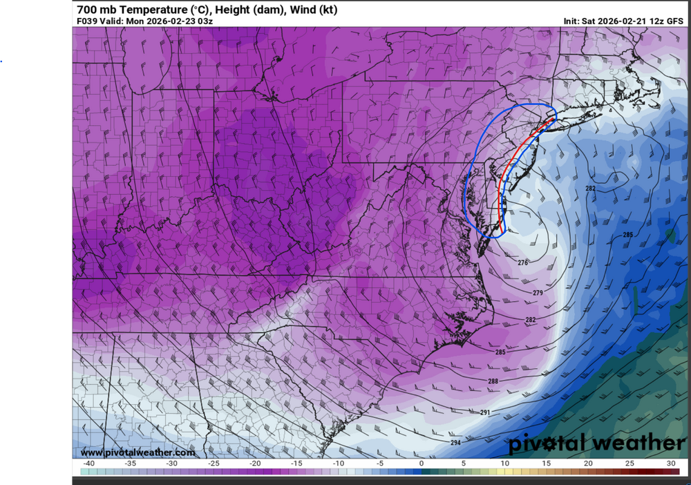
-
Southern MD / Lower Eastern Shore weather discussion
csnavywx replied to AnEndlessMaze's topic in Mid Atlantic
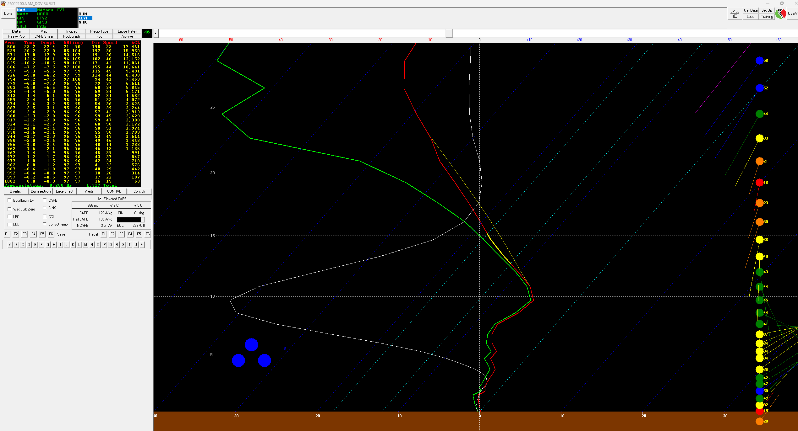
Getting dangerously close to forming a moist absolutely unstable layer (MAUL) in the boundary layer here. Wind is going to be a very serious issue.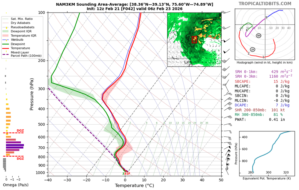
-
Southern MD / Lower Eastern Shore weather discussion
csnavywx replied to AnEndlessMaze's topic in Mid Atlantic
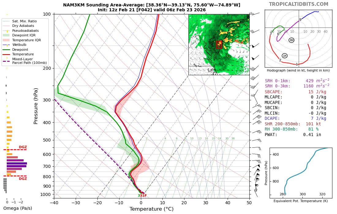
If all of that wasn't enough to get excited about, some of these soundings are exhibiting the potential for some thundersnow (this one's from Dover):
-
Southern MD / Lower Eastern Shore weather discussion
csnavywx replied to AnEndlessMaze's topic in Mid Atlantic
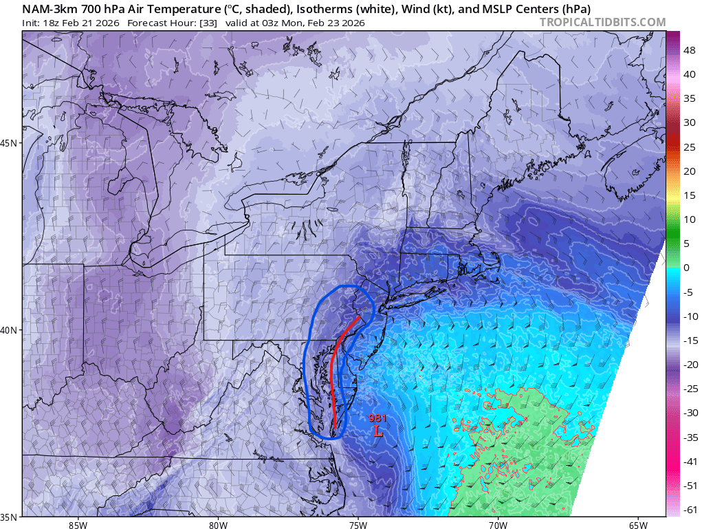
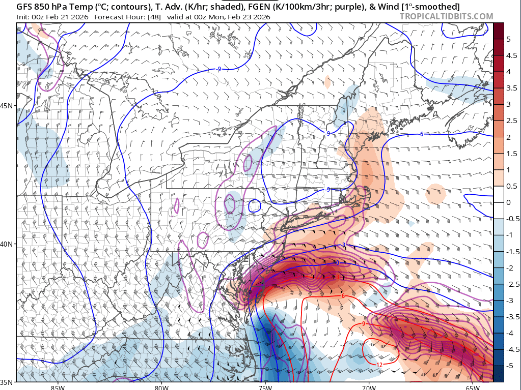
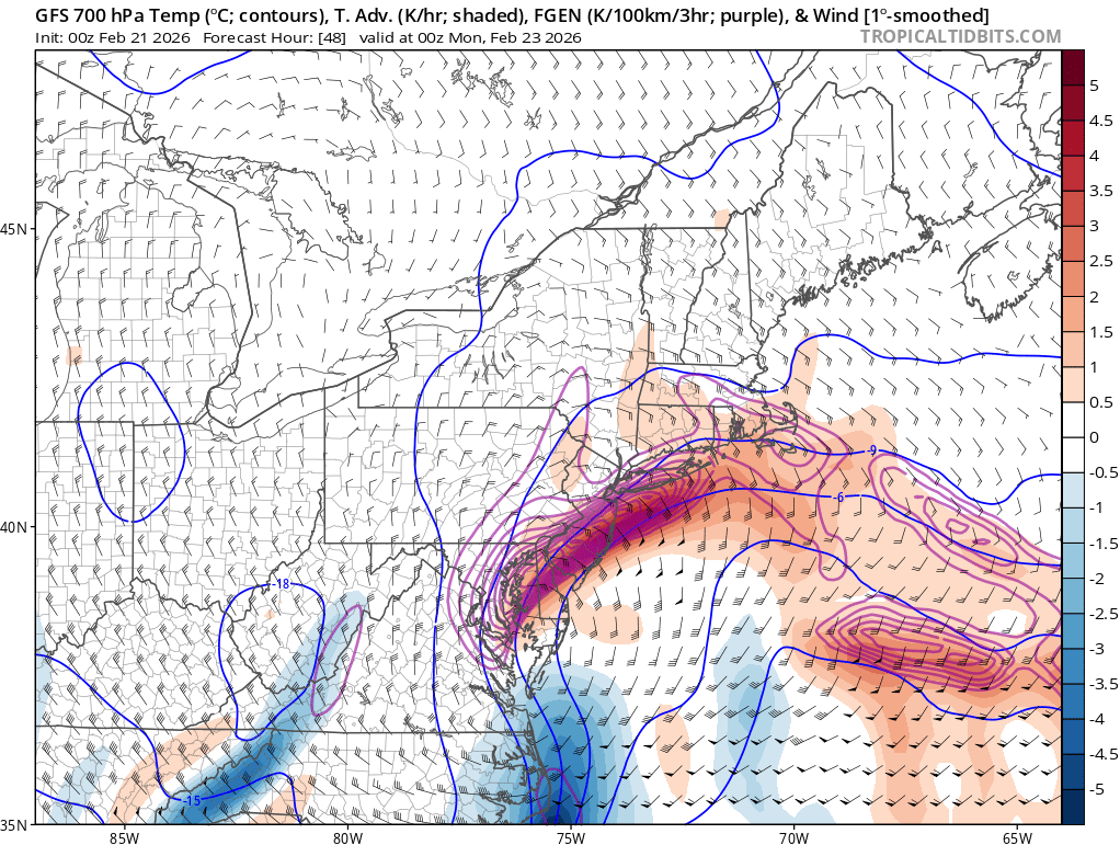
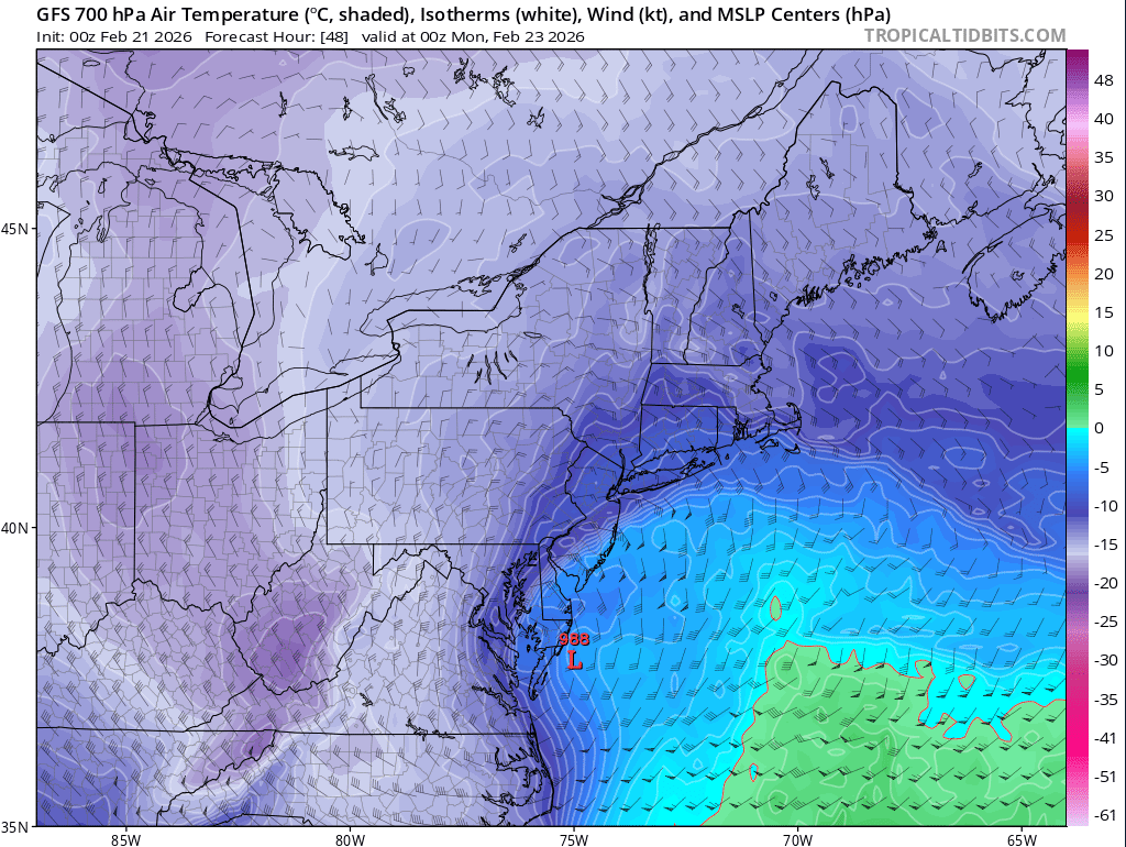
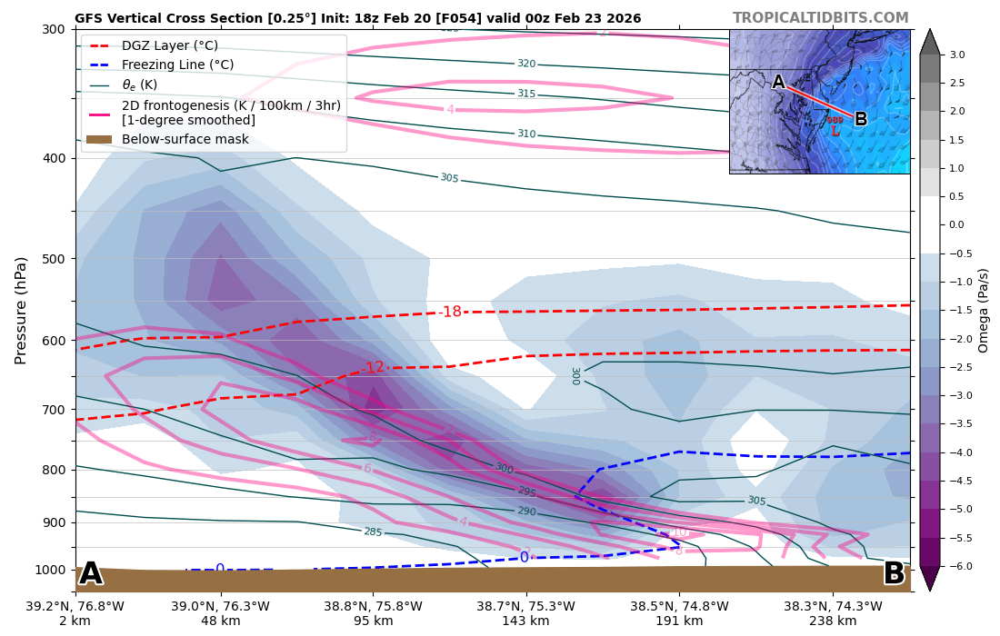
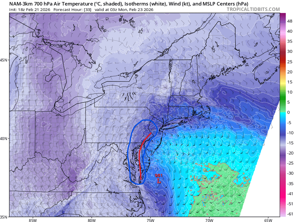
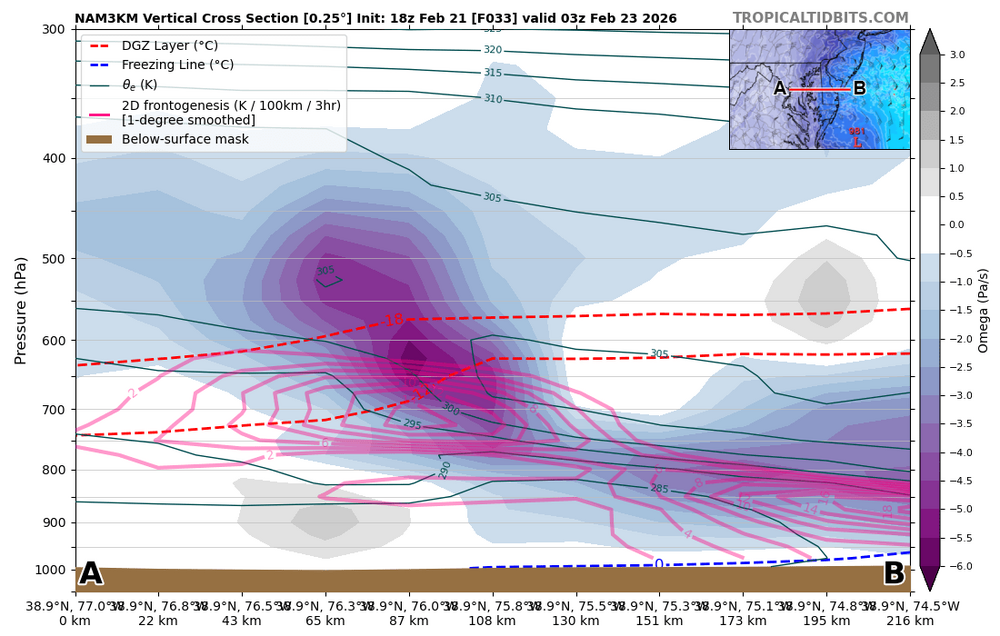
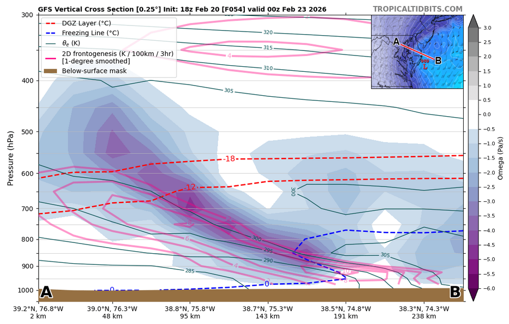
Liking the Easton to Dover corridor. I'd throw Salisbury in there too but I think SoMD and mid/southern eastern shore are gonna have to wait for the heavier rates to flip to snow. Got some work to do in the boundary layer first and we'll be attempting to do that during the day initially. Not really an issue after sunset ofc, but the sooner the flip happens, the higher the totals. Where that hellacious banding sets up is going to be pretty key. Intense 850-700mb frontogenesis will be present and the highest rates will probably be where the lift from the fgen circulation crosses the dendritic growth zone: Note where the 700mb front is: Rates are going to be pretty intense just about everywhere but the heaviest will probably be where the max omega crosses the DGZ here (just on the cold side of the 700mb front). So, given the temp profile in this storm, we can use that feature as a quick ruler to see where the best banding/rates will probably set up initially.


-
Hard to believe, but it can improve on that run. Tighten up the phase a bit more and neg. tilt a bit earlier (or just slower in general). Basically where the GFS has been for some time, lol.
-
Southern MD / Lower Eastern Shore weather discussion
csnavywx replied to AnEndlessMaze's topic in Mid Atlantic
Yep. We're 2 days til game time. Time to be serious. Forecast map I put up at the office had 10-16" over most of the Eastern Shore. Might have to nudge that up. Smelling a death band in there somewhere. -
Southern MD / Lower Eastern Shore weather discussion
csnavywx replied to AnEndlessMaze's topic in Mid Atlantic
Narrow is right. It's not as simple as simply coastal vs. norlun/inverted trough though. Even a partial tuck will result in a lot stronger convergence into the trough and much better moisture feed. So the "in between" solution is significant rain to snow along and on the north side of the surface trough. Of course, if we're really fortunate enough to get a coastal (still pretty skeptical on a full capture), then we're dealing with another beast entirely. BL temps are pretty poor starting out, so expect to have to waste a considerable amount of liquid getting that fixed. The stronger the lift and/or low, the faster that gets fixed. -
UFS mean forecast lowered to just above 2012 levels for upcoming season (down from ~4M in Dec to ~3.5M)
-
OHC backs this up, with record increases in 2025: Ocean Heat Content Sets Another Record in 2025 | Advances in Atmospheric Sciences | Springer Nature Link The overall increases from IPS are around 20-25 ZJ/yr, but the near real time CORA (Copernicus Marine) dataset is particularly extreme and sitting at almost a 100 ZJ increase from '23 to '25. That alone would be worth another ~0.15C for SSTs, roughly. I was skeptical about this year being able to beat the record, but it appears that this year or next might already be gearing up to do just that.
-
Wheeeeee METAR KPIT 070251Z 26008KT 2SM -TSSN BKN009 OVC016CB M03/M04 A2970 RMK AO2 TSB50 SLP082 OCNL LTGICCG NW TS NW MOV SE P0000 60000 T10281044 50005
-
Oh gotcha! Yeah, looking closer -- there's some nice mid-level DPVA superimposed over that surface front with the left exit region of that jet streak nosing in aloft. Good spot for something to happen. Hope it makes it down to at least our northwestern folks. Been a while since we've had a good arctic front driven snow squall.
-
KHZY reported VCTS earlier and I thought it was spurious too. Then KUCP picked it up and made me double check. Most of the lift and buoyancy is embedded in the -10 to -20C layer, so seems possible.
-
Seeing a few lightning strikes and ASOS stations reporting VCTS with that band coming into PA right now.
-
Southern MD / Lower Eastern Shore weather discussion
csnavywx replied to AnEndlessMaze's topic in Mid Atlantic
Looking For Group Page 3 -
Southern MD / Lower Eastern Shore weather discussion
csnavywx replied to AnEndlessMaze's topic in Mid Atlantic
Should finally get some flakes this evening/overnight. Not much but we take what we can get around here. Big gale tomorrow. Most of these wind estimates are lowballed, imo. Full sun, very strong CAA and a bombing low offshore should be more than enough to pull down momentum from aloft and make for some very strong gusts (50-55KT inland, approaching 60 at times near/over water). Depends on how deep the mixing layer actually gets. -
Southern MD / Lower Eastern Shore weather discussion
csnavywx replied to AnEndlessMaze's topic in Mid Atlantic
It's dwindling. We got our adjustment w/nw but it just wants to dig for oil at this point. Needed a bit more time and space to make it work. The suppression out front didn't help either. There are a multitude of reasons to never trust triple phasers and this just adds to it. Better chance of getting some consolation snow if you're out on the beaches ofc, but will take quite a feat to get it back at this point. -
Possible coastal storm centered on Feb 1 2026.
csnavywx replied to Typhoon Tip's topic in New England
The biggest source of spread has been the placement, tilt and shape of the primary max +PV/advection lobe as it comes into the upper Midwest. Most earlier solutions were emphasizing the middle of the axis to develop the primary PV later on, but generally this process favors the far end of the trough axis. Not really shocking to see it trend that way. I have my feelings about the NAM too, but given the sensitivity of the setup, models are still almost certainly still underdispersed wrt the true spread of the probability space, so seeing some notable dprog/dt on that feature is a good thing and shouldn't be tossed out of hand, at the very least.