csnavywx
-
Posts
5,506 -
Joined
-
Last visited
Content Type
Profiles
Blogs
Forums
American Weather
Media Demo
Store
Gallery
Everything posted by csnavywx
-

Southern MD / Lower Eastern Shore weather discussion
csnavywx replied to PrinceFrederickWx's topic in Mid Atlantic
Starting to look like some light snow late tonight/early tomorrow morning and into late tomorrow afternoon is a decent bet. H5 low and H7 trough pull a decent loop-de-loop on the Nest and NMM (and the latest GFS), which will allow for some gentle lift in/near the DGZ. Throw in some leftover moisture and we could see some fluff. -
Southern MD / Lower Eastern Shore weather discussion
csnavywx replied to PrinceFrederickWx's topic in Mid Atlantic
Gonna laugh if we all end up getting more than DCA, especially you. -
Southern MD / Lower Eastern Shore weather discussion
csnavywx replied to PrinceFrederickWx's topic in Mid Atlantic
Looks like you've got about 1-2 hours left before mixing. -
Southern MD / Lower Eastern Shore weather discussion
csnavywx replied to PrinceFrederickWx's topic in Mid Atlantic
All sleet now. Looks like I'll end up right around 3" of snow+sleet by the time this is over. -
Southern MD / Lower Eastern Shore weather discussion
csnavywx replied to PrinceFrederickWx's topic in Mid Atlantic
Don't look now, but there's a fat slider starting to show up ahead of a true arctic airmass next weekend. -
Southern MD / Lower Eastern Shore weather discussion
csnavywx replied to PrinceFrederickWx's topic in Mid Atlantic
Well now, you're making out pretty damn well today, aren't ya? WAA stuff always seems to deliver the goods. Just have to be willing to hump the mixing line to get the good stuff. -
Southern MD / Lower Eastern Shore weather discussion
csnavywx replied to PrinceFrederickWx's topic in Mid Atlantic
Can confirm here at Pax. Just started getting some sleet mixed in. Smaller stuff melts, bigger aggregates making it through fine. Kind of a mix of fatties, singed flakes and small ice pellets. -
Jan 31st - 33rd Storm Obs and Disco like it's 1979
csnavywx replied to Bob Chill's topic in Mid Atlantic
Ripping now. Been sitting between 1/4 and 1/2 mile for a bit. 1.5" otg. -
Southern MD / Lower Eastern Shore weather discussion
csnavywx replied to PrinceFrederickWx's topic in Mid Atlantic
Not really seeing that. Better chance of something after it cools down Mon night -- but even that would be freezing drizzle. -
Southern MD / Lower Eastern Shore weather discussion
csnavywx replied to PrinceFrederickWx's topic in Mid Atlantic
Euro throwing us a bit of a bone with the coastal and gets some wraparound in here late Monday into Tues. Not a ton, but seeing it cave towards the GEM isn't something I really expected. Might be able to eek out the butt end of a ccb band after all. -
Southern MD / Lower Eastern Shore weather discussion
csnavywx replied to PrinceFrederickWx's topic in Mid Atlantic
Yeah, primetime between 14 and 21z, shift that up an hour or two for places further east/north. Thermals get shaky from south to north after that, though it might rip right up through changeover. I'm thinking diabatic cooling keeps the warm wedge at bay until the rates relax and the dry slot starts to nose in and then the changeover will be really fast. Key question will be how quick the morning stuff gets going. Earlier the better, as that sets us up nicely for column saturation and gives a decent powdery base to accumulate on. -
Southern MD / Lower Eastern Shore weather discussion
csnavywx replied to PrinceFrederickWx's topic in Mid Atlantic
Still can't count on the coastal actually doing anything for us. It's a very chaotic/sensitive setup where popping the low and closed H5 circulation a bit earlier and further south like the Euro and RGEM allows us to cash in on some of it -- or a little later and further north where it can't help us (like the NAM). -
There will probably be some drizzle and freezing drizzle once the dry slot rolls in. Could be an extended period of it too. The reason is that cloud top temps warm above -10C as the dry slot erodes it away, leaving no very few ice crystals available for snow formation. Still plenty of moisture underneath that and some background lift though, so there will be drizzle. That's going to be an issue until/unless the coastal low can set up a reasonable def. zone and ccb to remoisten the column.
-
Southern MD / Lower Eastern Shore weather discussion
csnavywx replied to PrinceFrederickWx's topic in Mid Atlantic
That early morning stuff should be higher-ratio powder and lay down a decent coating (as well as saturate the column) before the main WAA shield arrives later in the morning. -
Southern MD / Lower Eastern Shore weather discussion
csnavywx replied to PrinceFrederickWx's topic in Mid Atlantic
Front end might get started earlier than expected. Quite a bit of lift progged with some f-gen and upglide pretty high in the column as early as midnight to 3am Sunday.
-
Just an artifact of how the model stamps out the lowest pressure even though that's not where the CoC is. That "low" is being printed there likely because of terrain effects and the fact that the primary over the OH/IN/KY border is filling pretty quickly at that point, causing the pressure at the old CoC to be higher.
-
Transfer is definitely a little faster on this run. Primary a touch weaker and further S to start with.
-
Southern MD / Lower Eastern Shore weather discussion
csnavywx replied to PrinceFrederickWx's topic in Mid Atlantic
12z runs have been a stepwise improvement so far. We definitely need the southern/suppressed trend to cash in on any backside stuff. While the Euro is kinda out on its own, it's a deadly model to bet against. -
Southern MD / Lower Eastern Shore weather discussion
csnavywx replied to PrinceFrederickWx's topic in Mid Atlantic
Will be spinning up some BUFKIT and digging in tomorrow on this, but that front end f-gen and WAA driven snow looks like it could actually produce some decent totals. Not sold on the back-end stuff. That's far more tenuous unless (again) the suppressed solution wins out. -
January Storm Term Threat Discussions (Day 3 - Day 7)
csnavywx replied to WxUSAF's topic in Mid Atlantic
Next week looks like a sloppy gyre of disappointment. Some light stuff possible around the slow-moving upper low or perhaps in association with the clipper-type shortwaves that drop in, but don't count on it. Thermals are just anemic for January. Not much quality cold air around to tap into over Canada either. -
January Storm Term Threat Discussions (Day 3 - Day 7)
csnavywx replied to WxUSAF's topic in Mid Atlantic
Hard not to be happy with that run. Way better than 00Z and trending the right way. -
January Storm Term Threat Discussions (Day 3 - Day 7)
csnavywx replied to WxUSAF's topic in Mid Atlantic
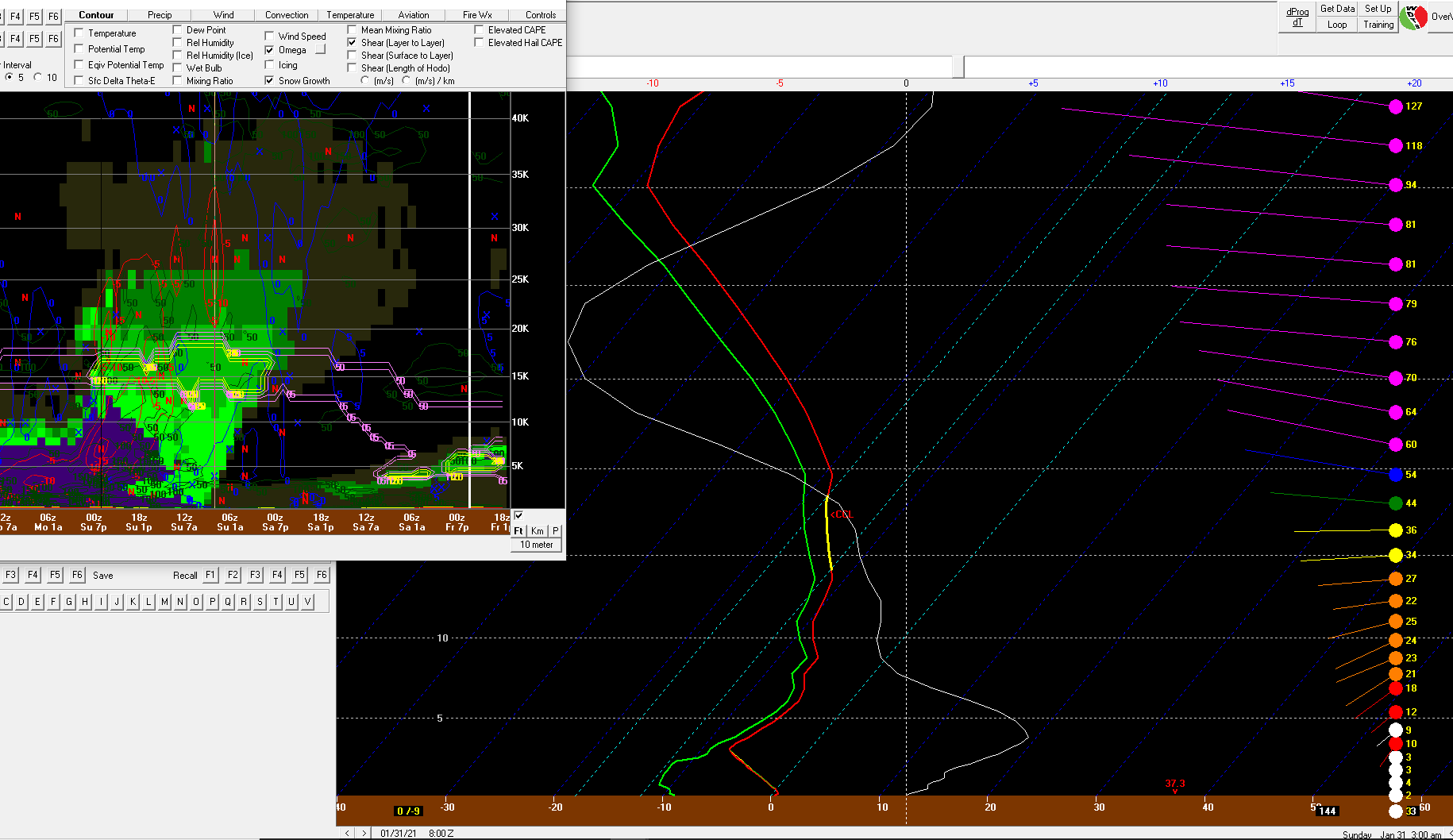
It is -- though drawing this up through BUFKIT reveals that the freezing level is down to 1700' by this point with just 25 J/kg of positive energy left. Definitely some BL issues on the front side, but not insurmountable. -
January Storm Term Threat Discussions (Day 3 - Day 7)
csnavywx replied to WxUSAF's topic in Mid Atlantic
Even the coastal areas can get in on the action with a low that pulls away as it starts to occlude rather than tracking up the coast. Allows the BL above the near-surface layer to cool off and let diabatic cooling do its work. Sun angle not an issue right now either (unlike a March setup). -
January Storm Term Threat Discussions (Day 3 - Day 7)
csnavywx replied to WxUSAF's topic in Mid Atlantic
UKMET has a storm now. Much closer to the GFS/Para/GEM camps. Still a fragile setup ofc, but marked improvement. The GEM being weaker shouldn't be surprising considering how amped and NW it was compared to its own ensembles last night. -
January Storm Term Threat Discussions (Day 3 - Day 7)
csnavywx replied to WxUSAF's topic in Mid Atlantic
No doubt there can be some intense banding with the type of explosive non-linear cyclogenesis this setup can produce, just warning in advance of the (likely sharp) cutoff. You're either in it or you're not type deal. One thing to watch in the globals is where the sloped f-gen zone intersects the DGZ or maxima higher in the column that can overwhelm dry layers. Sometimes, in the scenario you reference, a good indicator of misplaced banding can be teased out of looking at cross sections. We're a few days away from being able to talk about that realistically, but something to look for.