csnavywx
-
Posts
5,506 -
Joined
-
Last visited
Content Type
Profiles
Blogs
Forums
American Weather
Media Demo
Store
Gallery
Everything posted by csnavywx
-
It's amazing that after all this time they still exist. Propaganda works. Same tactics as the tobacco companies used to use.
-
Manufactured aggrievement syndrome. It's rampant nowadays amongst this and similar overlapping groups.
-

2021 Mid-Atlantic Severe Weather - General Discussion
csnavywx replied to Kmlwx's topic in Mid Atlantic
Not totally cooked tomorrow -- yet. There will be subsidence aloft for a good portion of the day and a remnant EML, so it will remain capped to convection for most of the day. Most likely evolution, if it happens, would be initiation over higher terrain and on the leading edge of height falls on the backside of the shortwave ridge. An old MCV from overnight convection to the west couldn't hurt either. There's ample instability and moderate low-to-mid level shear, so we're just looking for a suitable trigger. -
Ripping here now. NW 34G50KT Showers moving in from the northwest, though most of the precip is evaporating before hitting the ground.
-
It's high-based shower activity sitting on the top of an inverted-V thermal profile. Much more typical of the West, but in this case, with high gradient winds and a low tropopause. Most of the precip evaporates before hitting the surface, but strong evaporational cooling into a dry-adiabatic sub-cloud layer is able to efficiently mix down winds from aloft.
-
Observational evidence of increasing global radiative forcing
csnavywx replied to bdgwx's topic in Climate Change
That TCR value is quite high. 2.6 is on the upper end of most curves, iirc. -
And of course it does. The missing piece of the equation in that post is that flu's natural R is around 1.3. Sars-2 is around 2.5. The variants are 4+. It's much easier to bring that flu number <1 than it is to bring 2.5 or 4 down to <1. That doesn't mean mask mandates aren't working. Anything that slows transmission is effective. It just takes a more than masks for that to happen when the virus you're attempting to screen is this aggressive.
-
Because folks falsely equivocate masks, vaccines and travel restrictions with positive personal freedoms. If the virus infected them and they were the only person it harmed, it would be one thing. However, ignoring all of those things gets others infected, very possibly depriving them of their health, limb or life. These folks also usually claim to be originalists of the Constitution in some form, but forget that the Founders themselves advocated for quarantines and vaccines (see: Vaccine Act of 1813, for example). Science has advanced much since that time, but I doubt they'd be going against medical doctors, experts and medical science -- they certainly didn't at the time. We *could* have had something more akin to Australia or New Zealand or South Korea. Instead, we got madness and stupidity. Frankly, I can't hear anyone who wants to try and defend their anti-vaxx, anti-mask, anti-quarantine-measure positions over the pile of over half a million dead Americans. (It will probably be closer to 750k by the time all of the accounting is done properly in a year or two). Remember the Imperial College study early last year? Yeah, I think some people owe a big apology to them on their projections.
-
Or the Great Crash of 2029 when Dogecoin craters in value and leaves hordes in destitution as the nearly decade-long frothy speculative investing gambling spree ends.
-
2021 Mid-Atlantic Severe Weather - General Discussion
csnavywx replied to Kmlwx's topic in Mid Atlantic
Decent agreement on some sunrise surprise tomorrow morning. MUCAPE of ~1000-1500 and plenty of shear for morning TS. The big question I have is the evolution of overnight convection further west. If that decays slowly, then we may be left with a bunch of convective debris in the warm sector, and it's going to be tough for severe further north. -
It would get pretty bad any time the wind got above 25 knots there. Had some real doozies in the winter. Big ones in '03 and '04. The worst one I saw personally was actually caused by a series of haboobs over multiple days due to a stalled front in early May (a phenomenon known as the "desert front" where high-based convection would congregate over the Arabian peninsula around old elevated frontal boundaries and slopes around 850-700mb). Over 3 successive nights there were clusters of these haboobs over the deserts, generating massive cold pools and driving huge amounts of dust high into the atmosphere. It was dark for about 3 solid days in Bahrain, with the sun, if visible at all, as a faint orange-red disk. Dust got in everything that week, even indoors. I'll never forget that. It felt like living on another planet. '
-
It's curious that the WSJ article has NO figures, NO sources and none of the statements from ERCOT itself, which backed up the 26/34GW figure I provided. I want numbers, hard pass on the projection.
-
Sometimes those big aggregates can get a thin layer of meltwater percolating on the outside, which makes them very reflective on radar. Wetbulbing on the outside of the aggregate can also cause them to survive longer, thus making it through a warm layer that would melt smaller aggregates or individual crystals (which end up a sleet or fzra on the ground).
-
Expansion of echoes over the last two hours was way more aggressive than I was expecting and I even brought precip in earlier than guidance on my forecast because WAA events usually do that. Looks like a combo of strong DPVA, WAA and jet forcing are doing some serious work this morning.
-
26GW of the 34GW shortfall was from natural gas. Even Governor Abbott mentioned this on all the local stations he was brought on to interview with. Despite the frozen turbines, the wind shortfall was much less, around 1-2GW.
-
Southern MD / Lower Eastern Shore weather discussion
csnavywx replied to PrinceFrederickWx's topic in Mid Atlantic
Yeah, it was almost pure freezing rain down here and very dependent on wet-bulbing effects due to borderline temps. Tree tops and anything exposed is absolutely loaded with ice and anything close to the ground only has a glaze. Not uncommon to see near-surface objects have only a tenth of an inch but have half an inch of accretion several feet up. Shave off a degree on this storm and it would have been a disaster here. That being said, it was a very pretty drive in today with the overnight hoarfrost that grew on the ice. -
Feb Long Range Discussion (Day 3 and beyond) - MERGED
csnavywx replied to WinterWxLuvr's topic in Mid Atlantic
Please do not post this without cross-checking its sources. While short-range climate forecasts possess lower (but positive!) skill, trying to equivocate these with GCMs is a faulty argument on several levels and requires a rebutting that would derail this thread. -
Southern MD / Lower Eastern Shore weather discussion
csnavywx replied to PrinceFrederickWx's topic in Mid Atlantic
11% in St. Mary's and 8% in Calvert so far. Starting to lose small limbs regularly. Have heard a few bigger ones in the woods. -
Southern MD / Lower Eastern Shore weather discussion
csnavywx replied to PrinceFrederickWx's topic in Mid Atlantic
Got above freezing for a few hours this afternoon, but now back below with a moderate freezing drizzle. Tonight and tomorrow might get nasty with wave 2 in SoMd. -
I've been happy to be getting scraps down here after 2 shut-out years. Last year I had to scrape frost off my car a grand total of twice.
-
+TSSN at 14F in south TX definitely takes the cake.
-
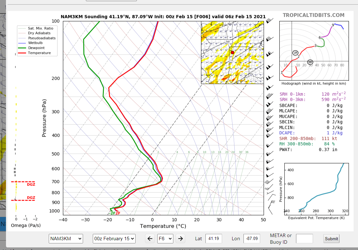
Doesn't take much with a profile like that.
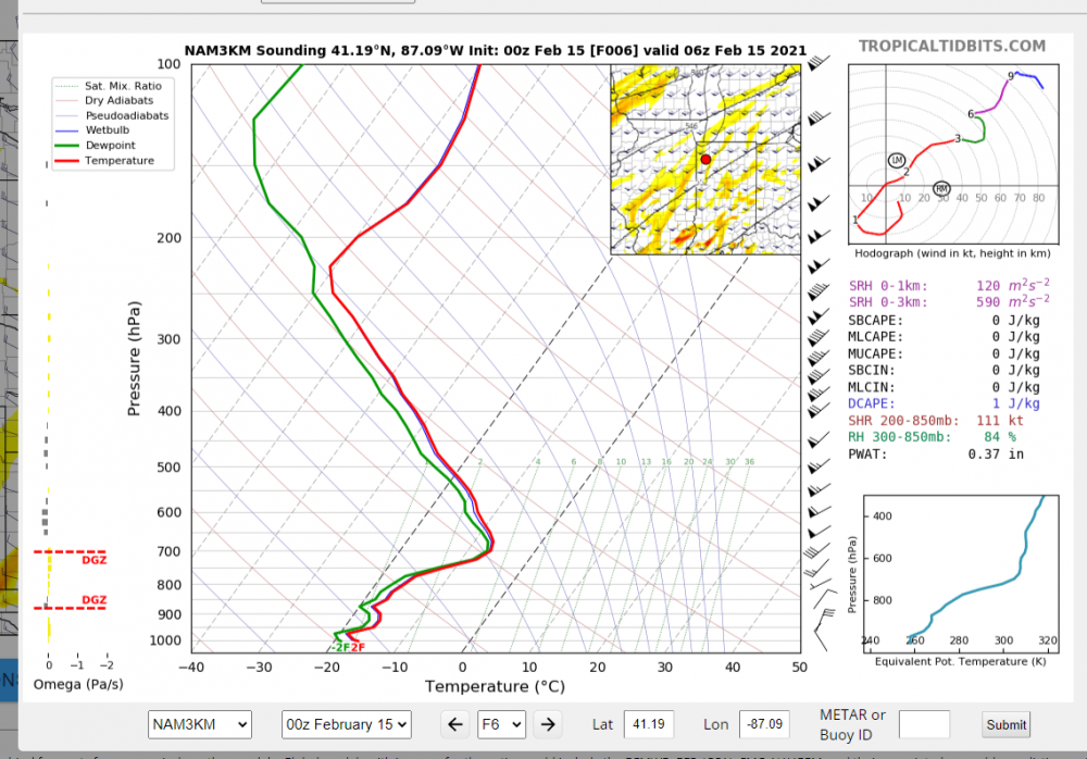
-
That's some truly extreme stuff. Skew-Ts/forecast profiles are absolutely nutty looking.
-
Good convergence and all now well NW of last night's 00Z runs.
-
It makes sense from an operational standpoint to protect your low end at this point until more guidance picks up the trend towards a more negatively tilted mid/upper trough, especially since an error of even 0.1 to 0.2 of liquid with 20-30:1 SLRs can result in a pretty sizeable bust. But I will say that the NAM has been absolutely killing it on the east coast at these ranges, beating even the Euro/UK (with the typical caveat about using high-res CAMs cautiously for some winter events). The GFS (and the new version as well) has been trending that way the past few runs as well, so keep a sharp eye out. It wouldn't really surprise me to see some convergence on that solution in the next 12-18 hours.