csnavywx
-
Posts
5,709 -
Joined
-
Last visited
Content Type
Profiles
Blogs
Forums
American Weather
Media Demo
Store
Gallery
Everything posted by csnavywx
-
The gap-up coming for July is pretty surreal, esp. considering that ENSO effects are usually still seasonally muted at this point (image courtesy of moyhu):
-
 The "price" is higher dewpoints. CO2 drawdown isn't really a thing beyond the delta you'd get by increasing planting density, which is already very high. Converting it all back to forest would work to a degree, but we aren't going to do that.
 -
Nope. Well documented increase in mixing ratios/dews to go along with that trend. It's a transient response almost by default since planting density is already very high and most of the land that can be farmed already is. Crank it a few more degrees and you set up a pretty vicious snap-back temp response once crops start having heat issues and the ET response is weakened.
-
Yep, and that's the problem. We don't know what the distribution necessarily looks like now and since the transient climate response is so rapid by the time you get enough data, it's already moved on. Needless to say, paleoclimate doesn't have many nice things to say about where we're headed. This sort of "climate flickering" happened in periods of rapid change in the past as well.
-
Yep, lived there for a while. Wouldn't wish that malaise on anyone and a few hours of exposure can kill you. 40 minutes of that nearly put me in heat exhaustion once. Most outdoor work is done at night as a result. And - essentially -- they are reliant on air conditioning at times. One of my favorite tells to see if it was safe to go out during the bad times of the year (Jul-Sep) was to look out my window and see if any locals were walking around in traditional garb. If not, I stayed put. They're adapted for it -- so the shit won't really hit the fan on this angle until we start seeing these kinds of conditions spread beyond the usual spots.
-
Weak OKWs breaking along the equatorial coast instead of more poleward certainly helping, as was the contribution from the EPac warm pool. Probably a mode that was more typical pre-satellite era, but we were used to the big WPac driven events. Perils of sample size, I suppose.
-
Good thing is that we're going to be able to test this prediction pretty soon. Agree that this year was like a coiled spring from a global temp standpoint. Key will be to see where that spring manages to jump to.
-
We're not yet to the point where we need to worry with WBTs. You need T/Tds of 100/85 or 115/80 type temps to hit dangerous levels (>31C WBTs) and 115/90 or thereabouts for true, hard habitability limits. 100/85 seems reachable in a few select areas for brief times, but Tds of near 90 don't seem possible yet.
-
Yeah, after this little batch of activity, I'd definitely be looking upstream to the outflow-reinforced front. Should be a really nice instability gradient and source of low level convergence for another MCS to come ripping east again tomorrow.
-
That rear inflow jet -- sheesh. Looks to be outrunning the reservoir of readily available instability though. Only the southern fringe is likely to survive into the evening hours. Given the strength of the RIJ, cold pool and advection aloft, might see some induced isentropic lift atop the "dome" and get some additional elevated thunderstorm activity to fire in its wake.
-
2023 Mid-Atlantic Severe Wx Thread (General Discussion)
csnavywx replied to Kmlwx's topic in Mid Atlantic
Meh, mostly a bust for our area. Cells struggled as they came off high terrain over N Va and most of MD. Needed a bit more BL moisture to avoid it being partially mixed out in the PM hours. Where that was available, they did pretty well. Ironically, we'll probably get better storm coverage today with higher quality BL moisture and direct forcing from the upper trough. Shear is light, so shorter-lived multicells only.- 2,785 replies
-
- 3
-

-
- severe
- thunderstorms
- (and 3 more)
-
2023 Mid-Atlantic Severe Wx Thread (General Discussion)
csnavywx replied to Kmlwx's topic in Mid Atlantic
Deeper mixing is indeed a failure mode here but the HRRR is probably overdoing it, esp if there is any debris in the morning from overnight activity.- 2,785 replies
-
- 1
-

-
- severe
- thunderstorms
- (and 3 more)
-
2023 Mid-Atlantic Severe Wx Thread (General Discussion)
csnavywx replied to Kmlwx's topic in Mid Atlantic
Yep. My favorite theta-e delta method (diff of average boundary layer theta-e and average minimum mid-level theta-e) is sitting around 30-35 deg. K on the 3km NAM. My typical threshold for summer severe is 25 or slightly less on global models along with 35-40kt of wind somewhere in the 700-500mb layer to provide adequate shear. In this case, we've got that and some directional shear. I'm still a bit wary convective debris from overnight activity here but if there's no big organized, long lived MCS upstream, then what cloudiness there is might actually help tamp down BL mixing a bit in the late morning hours. Leaning towards ENH being necessary here without major changes.- 2,785 replies
-
- 8
-
-
- severe
- thunderstorms
- (and 3 more)
-
2023 Mid-Atlantic Severe Wx Thread (General Discussion)
csnavywx replied to Kmlwx's topic in Mid Atlantic
Monday getting my attention. Remnant EML + DPVA from big, broad trough setups are pretty reliable producers. Still a bit far out and daytime mixing and convective debris are always concerns, though favorably cool mid-level temps make it less sensitive to boundary layer moisture issues.- 2,785 replies
-
- 9
-
-
- severe
- thunderstorms
- (and 3 more)
-
Warm pool in the NE Pac may be a contributing factor as well.
-
Finally seeing a bit of a trade surge near the dateline, albeit weaker and later than originally forecast a couple weeks ago and paired with (initally) westerly anomalies and outright westerlies north of the equator from 140W on east. That's likely the reason 3.4 has shot up quickly. Should see some flattening off of that trend once the trades pop back up in the next several days. However, this trade surge looks rather limited in duration. Perhaps 2 weeks tops. EPS is more like 7-10 days.
-
Btw, no argument that May melt ponds are a significant contributor! It's a good theory with consistent results. However, it's a tool like any other.
-
Yes, it's normally quite tough. In this case however, we've got a few "synoptically evident" drivers, two of which are STY Mawar and the location of the Pac jet (STJ). Once that recurves and interacts with the jet and baroclinic zone to the north, it is forecast to induce a large scale wave break via jet enhancement. This is a pretty common occurrence with large/strong recurving typhoons, it's just much earlier in the season than would normally be expected. A strong Bering Sea low and large scale downstream ridging resulting from that RWB is not conducive for the current +AO/annular pattern to maintain its grip. At the very least you would expect some significant disruption for a while.
-
The Canadian province fires experienced so far may just end up being a warm-up if this pattern is to persist as advertised and we may see another smoke-induced aerosol response.
-
Add in CFS weeklies (wk 2-4) and June monthly to that bin -- which have started aligning strongly with the projected pattern of the others.
-
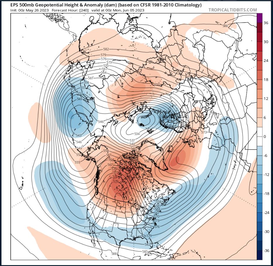
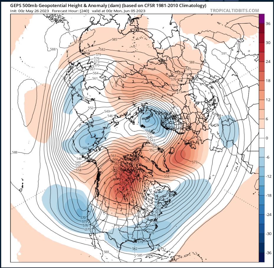
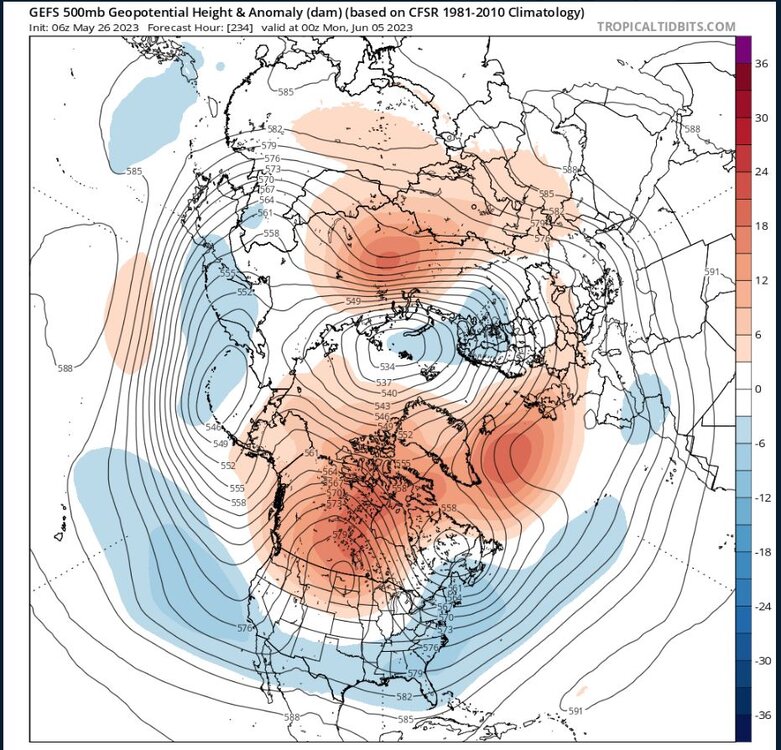
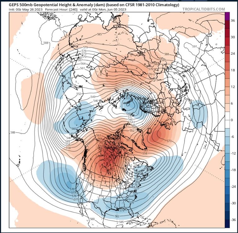
So far, so good and a cursory examination of MODIS reveals most of the ponding is in the CAA so far this year with some small early melt in the Beaufort. An annular upper level pattern (+AO) has been generally protective of the basin proper. However, possible +AD lurking dead ahead with a split stream pattern (enhanced ST jet well separated from a weakened polar jet) and that favors lower heights/cooler temps in the mid-lats/subtropics and enhanced blocking in the upper mid-lats to high latitudes:

-
Yep, read that one! Helluva interesting paper.
-
Yeah, and the strong pos IOD collapsing like that in boreal autumn is a coherent signal for Nina development the following year.
-
There were plenty of reasons to be bearish on a forecasted Nino in '18. No IOD help, lack of recharge time, lack of WWV, etc, etc.
-
The PDO signature erosion is overwhelmingly due to the insane ridging over the NW Conus and far W Canada over the past few weeks. More of that likely on the way, however that may not impact the southern half of the signature much at all. Looks relatively cool in the subtropical belt for a while yet, especially if blocking stays anchored well north (as currently forecast).