OKTWISTER
-
Posts
75 -
Joined
-
Last visited
About OKTWISTER

-
-
You do know they may be there the same time but have different mission parameters and altitude to allow different observations.
-
We have lacked one or more ingredients so far this spring in OK that have minimized potential. This looks quite promising especially six days out.
-

-
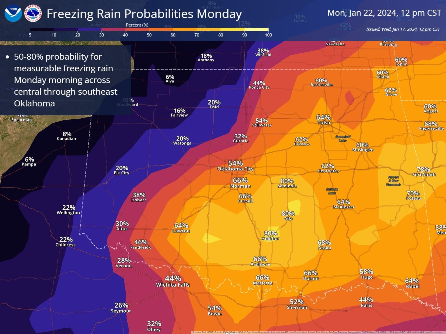
NWS Tulsa getting onboard for more snow on Sunday.
-
2023 Atlantic Hurricane season
OKTWISTER replied to Stormchaserchuck1's topic in Tropical Headquarters
Arlene has been used. -
You can not rule out a June Oklahoma event. Tomorrow marks the anniversary of the June 8, 1974 outbreak. Look at page two the graph very impressive event. https://www.weather.gov/oun/events-19740608
-
NWS Norman update on 2/26/23 event: https://www.weather.gov/oun/events-20230226
-
February 15-16 potential severe weather events
OKTWISTER replied to DanLarsen34's topic in Central/Western States
SPC Surface dewpoints will probably reach the lower-mid 60s in the Arklatex on Wednesday into Wednesday night. Model variability and greater confidence and a farther-west edge of low-level moisture/surface low placement in the southern Great Plains necessitated a shift of the severe probabilities west on Wednesday (day 5). Once model spread is reduced, a 30-percent severe area will likely be introduced. -
north trend

-
January 2nd and 3rd Severe Weather Threat
OKTWISTER replied to DanLarsen34's topic in Central/Western States
Looks like the system slowed down a bit allowing for a bit more severe weather to the west in E. OK. NWS Tulsa upped their tornado warning chart. -
https://www.wdsu.com/article/new-orleans-arabi-tornado-again/42247052
-
I agree as I do not think the fatality total will be anywhere near the high numbers on the list, I just wanted to point out the hyperbole being said without facts even being known.
-
Thoughts today from NWS TULSA Area Forecast Discussion National Weather Service Tulsa OK 542 PM CST Sun Feb 20 2022 .LONG TERM... (Monday through Sunday) Issued at 221 PM CST Sun Feb 20 2022 The forecast becomes increasingly complex as we move into Monday and especially during the Wednesday/Thursday time-frame. From the potential of severe storms Monday night into Tuesday morning to a wintry mess mid-week. Scattered showers and thunderstorms are expected to bubble up early Monday evening across southeast Oklahoma in advance of a cold front that is set to move through the area Monday night into Tuesday morning. In addition to the lift provided by the frontal boundary, a weakening disturbance in the developing southwesterly flow aloft will provide additional lift. There will be adequate instability and shear for some of the storms to become strong to severe. Large hail and damaging winds will be the main concern. However, there is a low potential for a tornado if a storm can remain surface based in the vicinity of the cold front. The greatest potential for severe storms will be across southeast Oklahoma into western Arkansas Monday night into Tuesday morning. In addition to the potential for severe weather, locally heavy rain will also be possible with precipitable water values around 1.5 inches during this time. Again, the heaviest rain will likely fall across southeast Oklahoma into western Arkansas. 1 to 2 inches of rain will be fairly common across this area with local amounts around 4 inches possible. This could lead to flooding of low lying areas. Have opted to not issue a Flash Flood Watch at this time. However, later shifts will monitor closely and issue a watch if necessary. The showers and storms are forecast to come to an end Tuesday morning as the cold front exits the region. Temperatures will be noticeably colder Tuesday and especially Tuesday night. Temperatures are expected to bottom out in the teens and twenties Tuesday night/Wednesday morning setting the stage for the potential of a wintry mess mid-week. With the cold air in place at the surface, at least two rounds of wintry weather are expected to sweep across eastern Oklahoma and western Arkansas Wednesday into Thursday. The southwesterly flow aloft will help provide the isentropic lift for the first round of wintry precipitation beginning Wednesday morning and continuing into Wednesday night. The second round will run from Thursday morning into Thursday evening as as mid-level shortwave ejects out of the Southwest US and across the area. During both of these periods all modes of winter weather will be possible. However, it is looking more likely that a good portion of eastern Oklahoma and western Arkansas will see more sleet and freezing rain than snow. Significant impacts from the sleet and ice are looking possible. Precipitation types and amounts will continue to be refined as the event draws closer. Stay tuned. After a dry yet chilly Friday, another chance of a wintry mix will come Saturday into Saturday night as a another mid-level shortwave sweeps across the area.
-
Severe Weather Outbreak 02/16-02/17
OKTWISTER replied to Tallis Rockwell's topic in Central/Western States
There is too much throwing out the word outbreak with limited data to back it up. Again today was not an outbreak by any means not even close. If the hype is all that is put out you will see people not believing it when the data really supports it. Remember part of the issue that was looked at after Joplin was the number of tornado warnings issued by NWS Springfield that were not backed up by what really was occuring. https://www.spc.noaa.gov/publications/edwards/defpaper.pdf