

Moderately Unstable
-
Posts
324 -
Joined
-
Last visited
Content Type
Profiles
Blogs
Forums
American Weather
Media Demo
Store
Gallery
Everything posted by Moderately Unstable
-
(1) Entries are allowed until the aircraft is "in storm": within the storm's circulation. Assuming this radius to be 150mi, at a speed of 240knots, they have around a half hour. (2) Should I allow guess updates (yes or no)?
-
Yes. 10-30 mins before entries close folks. They're closing in on the outer circ.
-
ESTIMATED PRESSURE/WIND CONTEST--SO FAR: Note: Entries and edits close once the aircraft enters the storm. LongBeachSurfFreak: 920mb/145kt The Ghost of Leroy: 920mb jpeters3: 895mb Moderately Unstable: 917mb/145kt sojitodd: 914-917mb Snowlover22: 890mb/155kt Newman: 910mb/150kt olafminesaw: 913mb/150kt Master of Disaster: 921mb/140kt Doc Jon: 888mb/155kt Will-Rutgers 925mb/140kt OhioWX: 923mb/145kt DDweatherman: 917mb/145kt yotaman: 915mb/145-150kt Floydbuster: 922mb/140kt BYG Jacob: 913mb/145kt That Hurricane: 904mb/160kt CatLover014: 919mb/145kt Orangeburgwx: 919mb/140-145kt tiger_deF: 890mb/160kts Normandy: 883mb/160kts Note: I will be offline the next half hour to hour, will update again when I return.
-
ESTIMATED PRESSURE/WIND CONTEST--SO FAR: Note: Entries and edits close once the aircraft enters the storm. LongBeachSurfFreak: 920mb/145kt The Ghost of Leroy: 920mb jpeters3: 895mb Moderately Unstable: 917mb/145kt sojitodd: 914-917mb Snowlover22: 890mb/155kt Newman: 910mb/150kt olafminesaw: 913mb/150kt Master of Disaster: 921mb/140kt Doc Jon: 888mb/155kt Will-Rutgers 925mb/140kt OhioWX: 923mb/145kt DDweatherman: 917mb/145kt yotaman: 915mb/145-150kt
-
I'm going with 917, 145 knots. Edit: Upped from 140 to 145 on speed based on pressure. I feel like 140 is more likely but I'm going to go ahead and swing high.
-
Place yer bets folks! Come one come all, try your luck! Guess the pressure and winds! Only 5 cents!
-
Well, while it is 2020, the year of anything is possible (tm), I think the analog years (2005), the continued warmth of much of the atlantic, favorable upper level patterns, and general trends both as a meteorologist and in looking at models all point to this not being the last storm. This will likely be a year in which we continue to see storm generation through November, into potentially December or even early January. The fact we have what is effectively a cat 5 at the start of November means that this isn't the last rodeo. In fact, most models the last few weeks have popcorned various new storms across the basin the next few weeks. The specifics change run to run. I don't want to get into the weeds here as this is more appropriate to discuss in the 2020 season thread. But, short version: this is probably not the last storm. This IS however almost definitely the most powerful storm of the season and historic for central america.
-
Well, I looked up the specs for a P-3. C-130's top out at 320 knots, so to get to 375 knots in a C-130 you need a strong tailwind. I'll go check. If they're flying a 130 I'm a little confused. Edit: USCAPEWEATHERAF is correct. Standby need to lookup the speed table for that now. I was giving the noaa plane speeds, apologies. Edit: Data says it has a 362 knot maximum speed. Clearly it's exceeding that. Regardless, faster than 320. To boil down all of this stuff--I think it's going to take em 3 hours based on the distance, and the point of my message is, they're maxing out the speed. That reduces range due to fuel eff reduction but probably not by too much and worth it at this point to get the data.
-
Indeed. I just did a bit of research, it has a top speed of 411 knots, which is actually very fast for a turboprop. Normal cruise is 328 knots. Something tells me they're trying to make up for lost time.
-
Well, lol, the plane is certainly booking it, given that it's currently moving at a brisk 375 knots.
-
(1) Definitely not a typical atlantic presentation. Absolutely off the charts impressive in every way. Yeah, could be at home in the indian. Amphan-esq. Though it morphed a bit, I think it had more wpac flavor earlier on. I am a bit at a loss for words. (2) http://wxmaps.org/pix/atlpot.png (3) EDIT: Finally got an ASCAT pass over....
-
I am racking my head trying to think about how to best communicate risk with people in Nicaragua. This is going to be a horrific disaster. There's just so much going on right now that it's probably not going to make the news and thus get the donations and aid they will need. Also it looks like everyone forgot about Felix vis a vis strongest landfalls. Governor Saavedra has just issued the following tweet: José Daniel Ortega Saavedra @DanielOrtegasa · 24m #Urgente El huracán ETA solo va a afectar a los puchitos. No vamos a declarar alerta nacional. Es solo agua y viento y el país no se puede parar, hay que activar la economía. Ya las 317 personas que iban a ser evacuadas lo fueron. Nadie corre peligro. Translating: 24m #Urgent Hurricane ETA is only going to affect a small number of people (literal translation: small people). We are not going to declare a national alert. It is only water and wind and the country cannot be stopped, the economy must remain active. The 317 people who were to be evacuated have been. No one is in danger.
-
Eh, I don't think most people based on what I've read the last few pages think it's a life-threatening situation to lack the plane. I think most folks, understandably, want one. I *do* think it's more than weenie-ness: those flights are actually quite useful to the nhc, and for our models to provide better forecasts, so they aren't just for fun, but I think all of us think this is the strongest storm of the season and as such, we want to know if it'll make cat 5, or where it is as a cat 4. Wilma had a 9 mile eye that contracted down to 2 nm at peak strength. I did see a couple comments talking about scientific research and you're right...research won't be adversely impacted. Obviously it will be if someone was going to do a case study of this particular storm but not in the grand scheme of hurricane research. To explain the sandwich thing a bit more, @Prospero, when you get into the land of crazy measurements, either with radar or satellite, you eventually run off the end of the color scale. That's what you're seeing there basically. Those are actually overshooting -90 or colder tops. You can overlay lightning on them at weathernerds.org to confirm that. Remember that lightning indicates charge separation, frozen water droplets, and strong updrafts...things you see in strong tstorm cells.
-
I wish there was a button for "concur" or "this is the correct answer". Like I feel like the trophy does that but it says thanks. There's no, "yeah that" button.
-
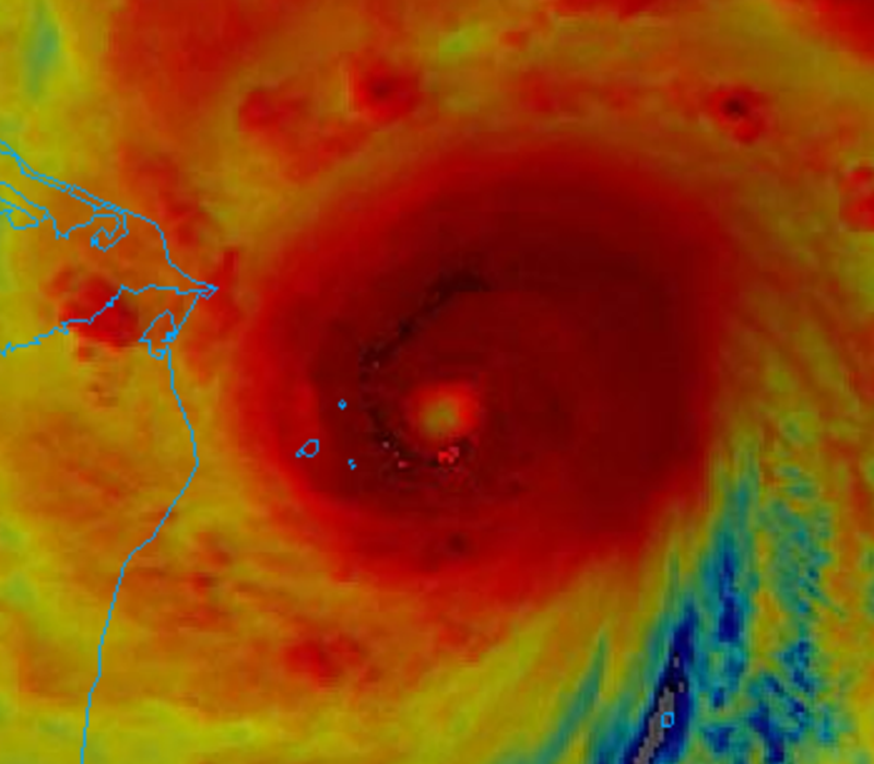
This is the best storm presentation this season, I can say that. Sandwich info: https://www.star.nesdis.noaa.gov/GOES/documents/SandwichProduct.pdf Summary: -It is a "sandwich" of both visible + IR imagery. It is useful during the daytime. -It allows you to better visualize both the top, and lower layers, of a storm rather than just one or the other. Edit: Answer to your question: As with any other temp-based IR, different colors correspond to different cloud temperatures, and thus heights and intensities of updrafts. As you know, hurricanes are collections of tstorms. So, you have a few regions which will overshoot the others. Perfectly normal.
-
Lol, we don't know what the issue is. It could be an instrument failure, it could be that someone on the crew came down with covid and the entire crew had to quarantine and they had to clean the plane. We *don't* know what the cause was. Flights are not cheap...so, no, it's a big cost, but that isn't the point. The pentagon has basically unlimited money so the problem here is not financial. They have flown a ton of missions this year into tons of storms. I used to study aviation bc I wanted to be a pilot. I can say with certainty that while aircraft are designed to handle weather, they aren't designed to fly regularly through strong hurricane eyewalls. Stuff breaks. Maybe the dropsonde mechanism failed. They did a dropsonde test shortly after getting over the water and right after they turned around. That's not normal. The mslp data stopped reporting after around 45 minutes, maybe that sensor failed. They could have had an engine failure, a pressurization failure, a warning indicator in the cockpit. Point is: a lot of stuff can happen. If the crew's safety is at risk, or the mission can't measure something it needs, they can't go. It isn't monetarily related and it isn't because they aren't trying. There are only so many crews to do these flights--they can't have everyone on duty at one time because then, no one would be available for the next flight. That said, at this point, if I were the nhc, I would call up a noaa plane if I could. I'm not them though and I'm confident they have good reasons. Remember that most places in the world don't get a flight into the eye...they just get satellite imagery and have to guess. We're spoiled in the atlantic. No one flew into Goni or Haiyan, yet somehow scientists were able to estimate the winds anyway. I know some of the experts in this field...they're good at what they do, and I trust them with or without a plane. I just *want* a plane because it would be helpful for storm structure, model guidance, track guidance, and pure weenie-ness.
-
Yeah, I am frustrated as well. I used to know Tomer. Smart kid. God I miss having potential. Anyways, I agree that the pattern of issues we've had recently with recon is disappointing. Smh. Also I did mention earlier that the moment this thing looked worse than perfect we'd have posters on here saying it's over. And wham bam they are. Could it be? Sure. Does that make ANY sense based on physics? No. Not at all. ERCs are common. Intensity fluctuations are common. The storm has a long time to go, and the *trend* given the environment is *up*. I do think we missed out on a potential historic data point by missing an in situ measurement. The lack of aircraft data is killing me. This storm isn't going to weaken any time soon. Don't worry folks, there's plenty of time to be excited by good appearances and then worried when it looks worse again for another 18 hours or so *grabs popcorn*. Edit: can someone ask the NOAA hurricane hunters to give it a go?
-
As I said a few hours ago, lots of lightning can signal an ERC. This is a small eye. Look at the cloud tops outside the eye, see the secondary eye there? The guidance yesterday suggested an erc could happen. If an erc occurs, the storm will re-strengthen again. ERCs take several hours usually to complete.
-
Well, I wouldn't call that a conservative jump. That's 20 mph, 15 knots, in 3 hours. That's aggressive. It's only conservative because the storm looks impressive. Also, *beware* that lightning indicates strengthening but also preceeds an erc. They went 110 at 10am, so 130 is a big 3 hour jump even if subjective data support 145-150. Depends on when they expect the plane. It's definitely doing what everyone said it would do lol. That microwave is in beast country. The post above proves my point about knowledge. Edit: lack of in situ data equals conservative estimate. Remember, a 3 hour increase of 10mph is a lot when you don't have objective data. That's a 24 hour increase of 60mph. It's a 3 hour drop of 5mb. It's probably strengthening faster than that but they need someone in that eye or ascat or both. We are now at 28/12/5.
-
Ok. Good on replacement mission. And as for board haters, I don't think they are haters per se. They've probably been around a long time, are knowledgeable, and get kind of annoyed hearing people fawn over every storm and obsess over its minute to minute changes. It isn't my style to tear someone apart for not knowing something or being passionate--I do understand why people could become jaded. I wonder whether or not it is tractable for the Nicaraguan government to evacuate that area. Last time a major hit them it killed a few hundred. The us does well with getting people out of the way, I wish we could export that support. Re lightning, yeah I've been following that. Does indicate continued strengthening which is not at all surprising. I agree on stability of eye, but the storm isn't landfalling yet. We may see an ERC so I hope we get objective data before then. Even if it does that though it has time yet lol. As for predicting next year based on this year, that isn't a good prediction model. Probabilities don't change year to year. If something doesn't happen in year 1 it isn't more likely in year 2. That's a classic human probability bias problem. Human brains are primed to assume if event doesn't happen now it must happen later. It's just as likely to have a cat 5 this year and next, as neither this year or next. Or, I should say, the odds are relative to the expected number of storms, mjo, enso. I agree, it looks like a cat 4 now. Without objective data it is hard to know what it is. It would be nice to have velocity data for the nearby radar. Edit: fun weenie fact, if you look at the eye motion right now you can see a nice trochoidal oscillation over the last few hours. Dope.
-
Lmao I don't think, well, I hope, people didn't think that. If I were nhc though I'd try to dispatch a noaa plane if the issue was with the air force division. Normally I'm pretty flexible but I think they should try and get someone in there. This walks talks and quacks like a historic storm. Also, going to generate some huge ace numbers if/when back over the water next week. Long lasting high intensity equals 30-40 for ace.
-
Any Twitter updates for why?
-
I agree on the sat presentation. I think that's why the professionals and amateurs alike are so enthusiastic. This is an excellently structured storm, and the closed eye prevents mixing of outside air and makes 2-3mb falls per hour reasonable to expect. I was more saying, patience. We've got 24 hours to go lol. T numbers are useful but not gospel. Earlier along I was watching the t numbers and felt they were lagging intensity. Now they may be overdoing it. The automated system is good but I prefer seeing stuff that a hurricane specialist has analyzed themselves when I look at t numbers. I use adt as a trend. If it is rocketing up the intensity, and the sat agrees, I generally expect strengthening. If the weakening flag is on and storm is in mediocre environment it can be an early clue to look for possible weakening. I try not to focus too much though on the specific number at a given time. Cimss does a great job but the system is rather complex in the way they figure out where the eye is, what constraints they use and the various rules that entails, etc.
-
You know, if you follow the senior nhc scientists and tropical system professors on Twitter, they're all foaming as much as we are over this one hahahaha.
-
Well, haha, I mean, I would be surprised if it was a 4. Hurricanes don't just flip a switch from 1 to 4. Even Wilma took 24 hours to go from 1 to 5. No matter how powerful a storm, the winds don't rocket up to space instantly. We are talking hundreds of square miles. An average hurricane has 108 BILLION pounds of water (a typical thunderstorm is around 106 million pounds). Momentum, p=mv. Mass times velocity. To translate that, you need a LOT of energy to speed up those winds. It takes time. I think it's a 3. It's got potential though. Now everyone can we agree that when the storm doesn't look perfect in 2 hours we won't freak out and think it's over?


