Moderately Unstable
-
Posts
324 -
Joined
-
Last visited
Content Type
Profiles
Blogs
Forums
American Weather
Media Demo
Store
Gallery
Everything posted by Moderately Unstable
-
December 16-17, 2020 Winter Storm
Moderately Unstable replied to Ralph Wiggum's topic in Philadelphia Region
Yeah, lol, if that happens I'll streak through the city. I'm still expecting 8-12" total where I'm at, north western part of town. 6-10 cc. Waiting for 21z sref. Attached 15z plumes for PHL. At this point short range models start being more useful and accurate on avg. Sref trended up btwn 9z and 15z. Still think sref is a bit low--dragged down by members predicting 0. Gfs is la la land high. There is low chance of Philly staying all snow, almost 0. Warm nose too big--needs surgery. I don't see 12+ in that scenario. Enough total qpf here though that I still find the range 8-12 most sensible for city. More in the burbs as usual. 3km nam snowfall map seems reasonable given the storm still in progress at hr 60. DT went surprisingly high.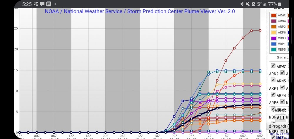
-
December 16-17, 2020 Winter Storm
Moderately Unstable replied to Ralph Wiggum's topic in Philadelphia Region
I don't buy 14 with that much mixing for the city. If that verified, it's going to significantly cut down the totals. Perhaps 14" of snow will fall...mixed with rain, mixed with sleet, etc. I would go with 6-8" for the city if that ended up happening accounting for overrunning and back end. But that puts the city in a dicey situation if the dry slot precludes some of the back end potential. Models vary run to run, still time, fingers crossed. Also note that the ratio there is 1:10. We should expect 1:7. This will be a wet snow. Note that the euro run suggests 6.7" of snow will fall in Philly in the 6 hour interval in which the precip pane shows a mix. That means (a) it is counting snow in that, (b) that seems questionable. I'm turning in, later folks. -
December 16-17, 2020 Winter Storm
Moderately Unstable replied to Ralph Wiggum's topic in Philadelphia Region
-
December 16-17, 2020 Winter Storm
Moderately Unstable replied to Ralph Wiggum's topic in Philadelphia Region
No I know they're used to indicate a pause or other sort of trail off. More in the context there where the statement was, there will not be 40" of snow (reasonable thing to say given qpfs, you'd need it to be very VERY cold), was more noticing bc that was the second time today I saw Mr. Birds using them in a post and it felt like it diminished the valid statement of fact. I'm realllly splitting hairs here and this is ot, I'm just pointing out the idea of, ya know, if you have a good thought or fact, a full stop period is good. Helpful content either way. The last post there "the euro will save the day", made sense with the ... I'm fun at parties. -
December 16-17, 2020 Winter Storm
Moderately Unstable replied to Ralph Wiggum's topic in Philadelphia Region
I agreed with your post more was asking why you used the ellipses instead of just stating it as a fact. -
December 16-17, 2020 Winter Storm
Moderately Unstable replied to Ralph Wiggum's topic in Philadelphia Region
Why ... and not . -
December 16-17, 2020 Winter Storm
Moderately Unstable replied to Ralph Wiggum's topic in Philadelphia Region
I'm genuinely confused. Why does everyone say 5-10 in the city when none of the models say that? Even the cmc yields 11, and that's the low estimate. There's lots of precip, and it's cold. What am I not understanding? Not trying to be aggressive or wishcast--I genuinely do not see 5-10 being shown on anything. Models have stayed very consistent. That means, the maps are not clown maps: they agree with each other more or less. Like if someone wants to explain why all of the guidance is wrong, I'm all ears. But if it isn't, Philly gets 8-12 as I said earlier today, and stand by now. I'm happy to lie in that grave if I'm wrong, it isn't a bold prediction. It is true that most of the time the burbs see more than the city. That doesn't mean the city gets 6" though. -
December 16-17, 2020 Winter Storm
Moderately Unstable replied to Ralph Wiggum's topic in Philadelphia Region
You're right on less vort org. Less than both the last several model runs of the gfs & the latest runs from the other models. Interesting that it lingers as well, that is significant but needs to be matched with the other models. So far that's an outlier...most runs of stuff' have been progressive. Could that be the "why" for its subsequent theory of lingering snow? -
December 16-17, 2020 Winter Storm
Moderately Unstable replied to Ralph Wiggum's topic in Philadelphia Region
Could you tell me, where does the ICON rank in terms of performance versus the gfs euro and ukmet for Philly? Not super familiar w/ICON. -
December 16-17, 2020 Winter Storm
Moderately Unstable replied to Ralph Wiggum's topic in Philadelphia Region
Lol, I believe you. It isn't a crappy model a la no gaps and co, I don't even know if they still run that. So many gaps. Just tends to be wet, over amped, and wild, vs the other contenders. Nam is the place to go if you like things wet and a bit crazy. Sometimes that's a winning combo though. . I mean, the main reason not to buy it, to my non expert eyes, is that it disagrees with everything else. Same reason you don't believe one ensemble member that says 30" when the rest say 3" or vice versa. -
December 16-17, 2020 Winter Storm
Moderately Unstable replied to Ralph Wiggum's topic in Philadelphia Region
Well, will be interesting to compare to other short range guidance. Sref etc. I just took a peek at the rpm model, can't post that, but it doesn't have the sleet pocket at the 72 hour mark (end of run). It does have a small sleet pocket over western VA similar to the NAM, but then that line doesn't extend out into PA as the NAM does. Perhaps suggests a potential for a brief period of sleet or ice in a mostly snow event. Definitely does not echo the NAMs craziness though. -
December 16-17, 2020 Winter Storm
Moderately Unstable replied to Ralph Wiggum's topic in Philadelphia Region
Why is it so strongly set on the inland solution? -
December 16-17, 2020 Winter Storm
Moderately Unstable replied to Ralph Wiggum's topic in Philadelphia Region
You know, looking at the model consensus here, 3 days out, I'm really struck by how far forecasting science has advanced in the last 30 years. The fact we can, with some reasonable degree of confidence, say right now, when it's in the high 40s in Philly, that we'll get crushed in the middle of the week by a storm that hasn't EVEN FORMED YET, is pretty dang cool. Everyone always jokes to me that meteorologists have the only job where they're allowed to be wrong. But frankly, when I see stuff like this, it makes me really appreciate all of the professors and researchers and forecasters that have advanced us to this point. Ask a 60s meteorologist to predict this using a paper map of the current weather. Another thing I like about systems like this is, they're not "easy" to forecast per se, but unlike marginal events, where you have to hunt around for tiny kinks in the height lines trying to read the tea leaves, the big systems follow some basic rules vis a vis how strong mid lat systems form and operate, and have clear boundaries, so it's less hair splitting and more actual meteorology. -
December 16-17, 2020 Winter Storm
Moderately Unstable replied to Ralph Wiggum's topic in Philadelphia Region
18z euro agrees with the gfs, high qpf, cold. Yay! Re WSA: quite true, but they seem on point. 5"+. 5 is the abs worst case I wrote down earlier. The fact is, no model, no ensemble member, says Philly et al gets advisory snow. May as well give folks more notice so they can get salt or what have you early, instead of all crowding in a store the day before the event..mid-covid surge. We know it will be a WSW, we just don't know the precise amounts yet. -
E PA/NJ/DE Winter 2020/2021 OBS Thread
Moderately Unstable replied to Rtd208's topic in Philadelphia Region
^^agreed. It is nice to look at. The bulk of the guidance is not on the GFS amounts train, though I don't think it's out to lunch per se. I think a lot of the gfs's progging relates to thinking super heavy precip rates will overcome all else. For Philly CC, my gut instinct at this point for a first call is, 5-8 if we see a snow-mix/rain-snow, 8-12 if mostly snow, 12-16 if phl stays mostly snow, and everything aligns just right. I'm a bit concerned about the dry slot timing on the backend. That's screwed the region in the past and is showing more of an issue in recent runs. Thus if I had to choose a single range, I'd go 8-12, with the (*) that more is possible. -
E PA/NJ/DE Winter 2020/2021 OBS Thread
Moderately Unstable replied to Rtd208's topic in Philadelphia Region
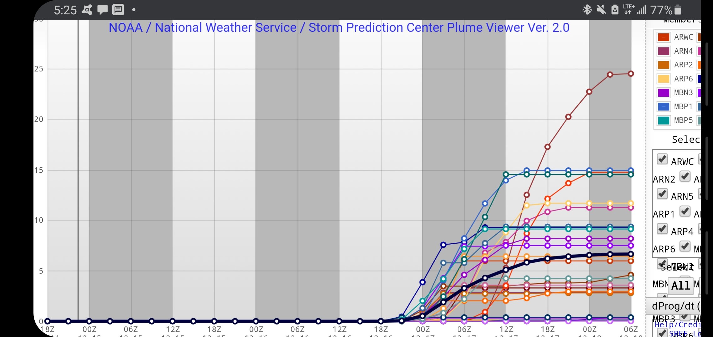
Double check to make sure it's actually accumulating (if it is, that is indeed interesting). For example, tomorrow, the NAM says 2-3" of snow could fall (snow accumulation graphic), but precisely 0 of that will accumulate (change in snow depth graphic). Also, remember that unless otherwise noted, rain:snow ratios are 1:10...since temps here are so close to freezing, ratios won't be 1:10, they'll be 1:7, 1:8...which is why Kuchara totals are lower than the non-kuch totals. Machine learning models are great, sometimes they don't pick up on big changes quick enough. -
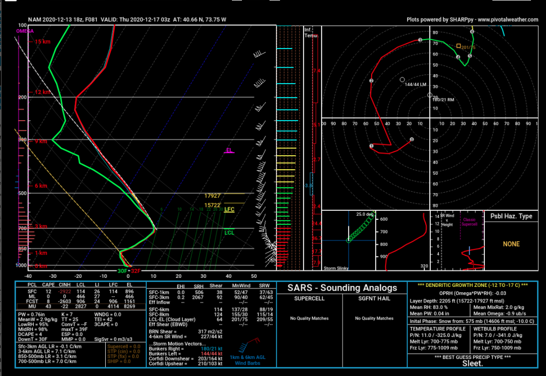
The NAM has in various thermal profiles across the NE a warm layer between anything from around 700/725mb to around 800mb. I could show more, but if you want to see why a model is progging fzra/sleet over your house, just pull up the forecast sounding for the hour in question. Sometimes the fixed pressure surface maps don't tell the entire story (whether or not it's a true story is another matter).

- 3,762 replies
-
- 2
-

-

-
- heavy snow
- heavy rain
- (and 3 more)
-
E PA/NJ/DE Winter 2020/2021 OBS Thread
Moderately Unstable replied to Rtd208's topic in Philadelphia Region
Ok, euro brings me back from the brink lol. I've been writing up an analysis (see below), but I'm taking a break now to go exercise, so this is incomplete. Also, I was mainly writing this for myself so it may be full of errors. On the off chance I say something helpful, posting below. /////////// Current Analysis (please take with giant grain of salt): Setup: Miller B type-ish cyclogenesis under a negative NAO, weak La Nina, PNA approximately neutral, may be trending slightly negative. A low currently over the eastern pacific ocean will traverse and be disrupted by the rockies, progressing into a trough over the southern and central US. Canadian high pressure builds over Quebec. Cold air damming occurs as cP air mass moves SE...Canadian high pushes and traps cold air against the apps. Trough/sw amplifies and move NE along the NE coast becoming a closed sfc low. Recent trends focus more on a developing low east of FL to phase with the low ejecting from the rockies which is more akin to miller A than B. Vertical Velocity Position and causes: S of Philadelphia primarily...NAM disagrees and thinks omega is higher further N, reasoning: 700mb low position (eh), 850 mb position, jet streak (UL divergence), LL convergence. Strength of WAA/CAA f(wind S, wind Dir, T gradient)....solenoids: ##todo Positioning of the low/rain-snow line: SE along a line between 20 miles SSE of Philadelphia to 5 NNW of Philadelphia depending on model run specifics. All runs indicate sfc temps sub freezing due to either precip rate or myriad other factors. Precip components: Overrunning Y/N--> Yes Central Y/N--->Yes Wrap-Around Y/N---> Unclear. Dry slot vs deformation banding. Model comparison: (to finish) GFS--> 12z Sun run weaker. At 06z Thurs, has the low up by 6mb vs previous run, and slower. Compared to runs over the past day, the 06z run low position appears to be an outlier, most of the runs keep the storm closer to the coast, and differ with strength and direction from there. The decrease in QPF seen in the 12z run (and thus, total potential snow) appears to be a function of less 6 hr QPF forecast at 00z Thursday vs earlier runs, which is itself due to the low being further south of the Philly metro at that timestamp. Despite these changes, the rain/snow line has been quite consistent since the 00z run. 00z, 06z, and 12z, all depict a virtually identical rain/snow line at 00z Thurs. This is not as true at 06z Thurs--earlier runs, including 00z Sun, had heavy snow reach further into NJ due to extreme dynamical cooling and FGEN effects, however, the 12z and 06z run are in fair agreement with a rain/snow line towards coastal NJ and DE. ECMWF-->Has the best positioning right now of the 700mb low in terms of maximal snow potential. 06z Euro brings storm further north than 00z, poss ptype implications. UKMET--> 00z run splits the difference in terms of southeast ridging between the 12z GFS solution and the 06z ECMWF solution with respect to possible temps during the storm's projected peak (around 21z Wed-09z Thurs). 12z run warmer, lowers snowfall totals in PHL from 13 to 8 or sig less (to finish). NAM--> Brings the low further north and closer to DE at 84 hours vs other models due to positioning the Canadian high further NE. Has the closest SFC low approach to Philly of any current or recent model run across models. As a result, projects much more of a mix than other models--the 12z run would bring a mostly freezing rain type event to the Philly metro, with up to 0.5" of freezing rain forecast to potentially fall by 00z Thurs. Pulling up a sounding, this is due to WAA between 850 and 700mb. In fact, the NAM actually suggests that the surface temps will be colder than other models suggest--but is so aggressive with the mid-level conveyor belt WAA that it makes much of the event FZRA. I agree with earlier analysis suggesting the NAM is too amplified. EPS vs GEFS--> EPS slightly closer to coast. Edit: NAM time stamp. -
Haha, well, I DID go to school for Meteo, and hold a degree, and STILL don't work in the field. You'll encounter that a lot--there are way more METs than jobs. If you don't have a masters, or experience, don't expect to get into the NWS or similar (it isn't like it was in the 80s). Many other met jobs in the private sector don't involve forecasting and/or pay very poorly--even some in television. The fact is, computer tech has gotten REALLY GOOD, and you only need so many people to make the models, run the models, and forecasters to interpret the models for a given region and specific niche. Whether you're talking airlines, trading markets, forecasting companies, television, government--it is VERY competitive. I went to PSU--they have a very large program. Every year, they graduate many dozens of METs, just at PSU, every single year. There are lots of MET schools, multiply that out, then consider that a tv station may have 3-6 mets, NWS office may have 10-20. To reiterate--many mets don't work as mets. It is a very fun field, and when it WAS more of a niche major, getting a B.S was sufficient to get a good job either at the NWS or private sector. That is no longer the case. And this is not even accounting for the importance of connections--who you know matters as much as, and often more, than what you know. That's true in most competitive skilled fields, and meteo is no exception. When I was in HS, I volunteered at the Franklin Institute. My supervisor was a met grad--he didn't like talking about meteo though (I got the sense he was a bit upset at not working in meteo). Little did I realize then that that's the norm rather than exception. I've also run into many mets since graduating, who do not work in MET. So, to get around all of that I tried to go to grad school, changed my focus from forecasting to climate change, etc etc. But, I wasn't as motivated because even though climate science is very important, I got into weather bc of severe weather forecasting/winter storms etc. So, I didn't do well there, had some issues of my own, and left. Over several years, I reoriented myself with completely unrelated work, while transitioning to pursuing a masters in comp sci. I miss meteo immensely, particularly doing research, and to this day, I wish I'd worked harder during my grad school stint--it is perhaps the single greatest regret of my life. But the fact remains that hobbies and passions have to intersect with job demand and money, to actually be worth it. I could re-apply to grad schools, retake the GRE, etc. But, I already got into another masters program in comp sci, and it makes more sense for me at this point. Therefore, when considering whether to go to school for meteo, or go back to school for meteo, your real first question should be, if you do that, what exactly do you want to do with it when you graduate? After you answer that, do some research and find out how many actual jobs entail that requirement. Perhaps you'll be in the top 20% of your class, and be part of the group that then does not want to go to grad school, but if not, you will have competition. You will also face competition from students who may attend other schools (which may hold higher reputations), from current mets that hold degrees and want to work in the field and have taken other jobs to hold them over while they look, etc. And some employers would indeed ask and scrutinize why you did not initially pursue meteo, why "now", even in holding a degree. Others would not. Also, as both a business manager, and a card carrying meteorologist, I can also tell you...in every profession, meteo included, we don't hire people solely based on their credentials. We look at your whole resume, your cover letter, we talk to you to see how you could fit in with our team, see what you actually know, how long you'd probably want to stay, and get a sense of your personality (aka, an interview). One thing you may be able to do NOW, is find a part time volunteer or paid job working with one of myriad online forecasting groups (see facebook, not a joke). Experience matters. Now, the separate question to address is, would a school even accept you. On this matter, I have a very strong, and probably relatively unique opinion. If you go through the analysis of benefits and drawbacks, as I mentioned above, and determine meteo is a good choice for you--you should NOT let fear of being rejected stop you from trying. Apply. Reach out to the department head and ask them. YES, some schools WILL look negatively on trying to return to school after trying before and will reject you. Try anyway. The fact is, you don't need everyone to be on your team--you need one person/group/school to be on your team, that's it. When I read posts where people ask "can I do xyz if abc", then see posters explaining all the reasons why the answer is "no", it makes me cringe. Don't dissuade people from trying something they're passionate about if it's even remotely reasonable for them to do well with it. Fact is, if you don't give something a shot, you won't actually KNOW what said people will do. Humans are not machines--if you have a good essay that explains your background, why you want to do what you're applying for, links up your existing experience with how this new position/education could help you...that gets factored in. So do good letters of rec. Sometimes I think people get so hung up on wanting to go to, say, MIT, that they don't realize that the actual school, while important, is not as important as people think. Be judicious in explaining your past failures. I would personally, if I were you, emphasize how your work experience has allowed you to grow intellectually, become more mature, and improved your work ethic (be specific and use examples). Lot's of college kids do dumb things--you made mistakes, you fixed them. Include a couple tidbits that highlight your existing meteorological knowledge and passions--try to specifically explain what in meteo makes you excited and get into the weeds a touch to show you know more than the first two sentences of a wikipedia article on the topic. Explain why you'd do well now--really think about this since it's important you give a good reason, and you yourself believe that reason. If you do explain your past switchover, it is reasonable to say that you were immature, didn't fully know what you wanted to do (understandable at that age), and made some mistakes, including not continuing with meteo. Some people will give you a second chance, if you show them clearly why they should do so. You may also wish to consider applying to a graduate meteo program instead of ugrad. You've done ugrad, you have a degree in a semi-related field, you may be able to go straight to that level. Depends on how much math/physics etc you've done and what you still remember now. To sum this whole paragraph up though: If you decide, based on whatever reasoning, that you want to go to school for meteo, apply, reach out, and try. Do not sit here on the internet waiting for someone to give you a green light or strike you down. I really truly wish I could go back in time and tell my younger self that. If you try, and get rejected, find out why, find out how to fix it, and if you can't, be proud of yourself for making the effort. However--I really cannot stress this enough: Meteo is very fun; I still enjoy even the mathematical parts (I'm reviewing an old lecture about diagnosing vertical velocities using horizontal convergence and divergence right now). But, if I were in your shoes, I wouldn't be worried about my ability to get into school, I'd be worried about my ability to get a job after school. Not because of your age, just because, as I said--it's a very VERY competitive field, so if you've got something going that's good (e.g a good job with good benefits), be careful about throwing that away. The entire job market now is competitive--I've had masters graduates apply for roles at my company (in roles that required a HS diploma). Consider finding something that's MORE enjoyable in the field you're in, or one in which you have connections and some experience and existing knowledge. Going to school for 3-4 years to gain knowledge is fun, but don't throw away something good because you want something better. You don't have to work at a job that leaves you unfulfilled, but try to find ways to do meteo in a more limited way first before you jump the boat. Hope this helps.
-
E PA/NJ/DE Winter 2020/2021 OBS Thread
Moderately Unstable replied to Rtd208's topic in Philadelphia Region
Lol, I'll do it later today and I'll accept the scorn I rightly deserve if it blows up in my face. Right now however I'm looking at the 700mb VV progs and trying to write down what's causing it. Also need to figure out the 700mb low track and the why there. I feel that will give me a better handle on the places the models disagree and which option makes more sense in this setup--negative NAO, trending more negative, not great PNA. To be clear, the physics here will support a decent snowstorm--and some portions of the area should see heavy snow, hence, a dedicated thread makes sense (this is an Obs thread). This will, as well put in an earlier NWS AFD, be a battle between precipitation rate (and thus dynamic cooling), and warm air advection. Right now, the models are pretty confident that precip rate wins--they suggest as much as 12"+ of snow to fall in a single 6 hour window, which correlates to an average of 2"+ an hour. That would likely be sufficient to keep temps at freezing and produce a more-snow-than-not event for Philly. Figuring out the mechanisms for that to happen will be useful in determining probabilities. Edits: grammar, error of fact in one sentence. -
E PA/NJ/DE Winter 2020/2021 OBS Thread
Moderately Unstable replied to Rtd208's topic in Philadelphia Region
I'll have more to comment on later. Want to see the full suite of guidance before going too crazy. I don't think anything has truly changed in the macroscale in the last few hours--the 00z gfs so far basically confirms the setup vs lending to any kind of refutation of the thinking (vis a vis the 18z blip). We're still too far out to look at the mesoscale models or even the NAM so we're in a limbo period--we can see approximately what's going to happen now, we don't know the precise axis of dilitation, timing of any deformation bands, and other finer-graded minutia. At this point, without being the grinch for jinxing us, I would be shocked at less than 8. I would be fairly confident with a foot, and 16" using kuchara is within range. Remember that many years ago, the models were bulliish on the 09 blizzard, then the NAM came in and blew them out of the water. Everything so far has said this is a major event. Therefore, this isn't looking good for 6, for 4...it's a honker. Concurrently, if the storm did "bust", it would be disappointing--even though *technically* we have not seen this type of accum in 2 seasons (even if 6" fell)--but where we are right now is a major event. 00z GFS run even makes a brief go at blizzard condition criteria for Philly. However I also remember several times the last few years in which a major storm was progged (12+) and it MAJORLY busted. Thus, caution is a virtue, but take what the consensus of models are all saying with some confidence. Note: edits for grammar/style. -
E PA/NJ/DE Winter 2020/2021 OBS Thread
Moderately Unstable replied to Rtd208's topic in Philadelphia Region
Yes, the 00z run is phenomenal. I'm so excited I actually can't think of what to type right now . But you're right, this is as good as it gets. -
I'm in the wrong forum but YAY!!!!!!!!!!!
-
I feel bad for everyone's washing machine. Everyone's going to need to wash their pants now.
-
E PA/NJ/DE Winter 2020/2021 OBS Thread
Moderately Unstable replied to Rtd208's topic in Philadelphia Region
Lots of good discussion right now on this whole setup in the Mid Atlantic forum. But, yeah, I mean look run-to-run is going to look different, that's the game (makes it fun)! EPS 18z looked solid, made 18z gfs look like an outlier. 18z gefs was reasonable as well. Still plenty of time--we're nearing the place where the op models and their ensembles converge enough to switch over to the op (though just to throw it out there--there's never a *bad* time to use an ensemble...averaging perturbations does well to ameliorate the woes of chaos theory at hour 100 and also at hour 10). Going to be a solid storm for the Philly region regardless, this is more a question imho of weenie solution MECS vs a more standard SECS. I want my MECS (unfortunately I don't think HECS is in the cards here using the statistical 1:10 year standard, but hey, I'll keep hoping). Suggest poss creating a dedicated topic if the 00z runs continue to indicate or trend for major storm (really seems warranted regardless now).