

Moderately Unstable
-
Posts
324 -
Joined
-
Last visited
Content Type
Profiles
Blogs
Forums
American Weather
Media Demo
Store
Gallery
Everything posted by Moderately Unstable
-
As we have already seen, with this storm directly in fact, what happens tonight has very little to do with what happens in 2 days. The nhc weakens the storm near landfall for sound meteorological reasons: the water is cold near the coast, shear increases near the coast, and perhaps dry air tries to entrain the circulation near the coast. If ALL THREE of those things hit at maximal extent, it doesn't take a PhD to recognize significant weakening would occur. Storms can rapidly intensify, AND as we saw, rapidly weaken. Ergo, don't fall into the forecasting trap of seeing something happening now and assume that it must be true later too! *If the storm is stronger at landfall, it will be due to a high rate of forward speed and having limited time for these objectively bad for the storm things to impact it*. Cold water weakens hurricanes. So does shear. So does dry air. *There is no physical mechanism near the coast that is expected to be favorable for hurricane maintenance and strength*. The degree of unfavorability and landfall intensity will come down to shear and any dry air entrainment. We know the water is marginal. If no shear or light shear is present, it will exceed the forecast intensity at landfall. If shear is moderate, or the inner circulation entrains dry air, the storm will weaken about to the degree the nhc is noting. Yesterday, we had warm ssts and modest shear and bam, cat 4 drops to cat 2 on a dime. That was in a supposedly pristine environment. Right now we are continuing to see steady strengthening. That's what we can say objectively. Not how that affects landfall. If the storm were 12 hours from landfall and strengthening, different story. MU/CD
-
Combined, the latest vdm message and current sat imagery make a compelling case that the eye is clearing out, banding has increased, and the storm is looking healthier...all point towards steady--not rapid but not nothing--intensification and with hints of a clear eye now showing on the simulated visible satellite we will probably be back at Cat 2 on the 11pm update. It should be noted that the 00z intensity guidance has been released and almost all of the models show a cat 2 peak now, even the often bullish ships. I don't totally buy that because of the underlying ocean temps and overall setup, and the frank fact that this storm doesn't need all that much to get to cat 3 strength--organizationally speaking. But the earlier post I wrote coupled with the current imagery continues to lead me to a mid grade cat 3 solution. That's not exactly GOOD news for the areas to be affected by this thing, largely the same ones still recovering from Laura. This is like having a baseball hit you when you're already opened up for surgery. Ouch. I want to quickly note that in mature steady state, strong tropical systems, we don't see a ton of lightning around the eye. That indicates one of a few things. One is and EWRC. That ain't happening here. Two is very vigorous convection--which usually correlates with a strengthening cyclone but not always. We DO have that here and that is the cause of the lightning. The same way you get lightning in your garden tstorms (side bar, hurricanes are basically a conglomeration of garden variety tstorms that basically synergistically combine to create the pressure falls and structure that become a hurricane--"garden variety" tstorms form in barotropic environments), you get in tropical systems. That is--high cloud tops, vigorous updrafts, and charge separation of the resultant cloud droplets with height. But hurricanes are wind storms. Lightning tells us about the updraft strength, not how much energy is focusing into cyclostrophic balance in the RMI. They are correlated, they are not synonymous. What has me going "ah this is probably a cat 2 again" is the symmetry I'm seeing of the eye itself now, and the fact the hunters found a closed eye. That is important in creating inertial stability and reduces the impact of short temporal scale extrinsic storm influences. On the latest T#, it is not 7.3. That is the raw number, and as the system noted, it estimates a 10 km pinwheel eye. That is incongruent with aircraft in situ measurements stating a 30 nm closed eye. The adjusted T number given is 5.0, meaning a mid range cat 2 storm, using one particular computer algorithms estimating technique. A T 7.3 corresponds to cat 5 winds. This ain't that. I buy T 5.0. MU
-
Sock puppet eh. What show do I star in? I can't wait for my reviews! Based on the last couple of days, RI may be relative. What was seen a couple of days ago was voracious and unusual. We should, based on the recent imagery coming in, expect I. The guidance says we should see more intensity, the microwave and IR imagery is improving, the above post referenced by Windspeed and JasonOH was in particular an "oh, well then", moment. I am taking the same approach as the NHC likely is about to right now, in not jumping the gun and rapidly changing their thinking. Hours back, folks were saying, it may be a 1! What a joke! etc. We can't swing 1-4-1-ts-4-5!. I still think a cat 3 peak is the most likely scenario. Big cat 3, maybe upper end cat 3, with extensive surge impact. But right now I go mid cat 3. Outflow does look a lot better, and historical context suggests good outflow is key in terms of sustaining and maintaining a clean core, which appears, again above, to be developing. To the two earlier posters who said the nice things/welcomed me--thank you :). It is nice to have a place to discuss weather without being looked at as though I have three heads. MU/CD
-
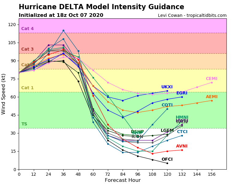
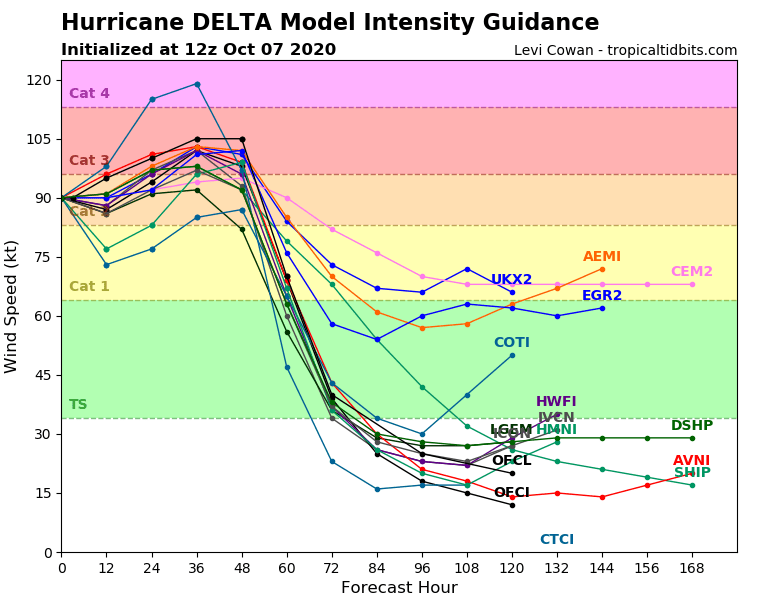
Yes, I agree. The 18z intensity guidance just came out and it has again trended down--slightly, and mostly due to lower initial intensity. Most of the models made the storm a cat 3 in the 12z runs, now more keep it high end cat 2 with slower strengthening, or low-end cat 3. You can see from the spread that we should know in about 12 hours whether to go with the bullish or conservative guidance, which makes the difference between mid-2 and mid-3 by the end of the period in which strengthening is possible. The models are capturing the potential--the energy available--but not necessarily what we are actually seeing. All the guidance says, the storm should be strengthening now. The current sat presentation is as it has been--cycles of incredibly intense convection, presently that's expanding in area again, but no clearing of the eye. I'm particularly monitoring the southeast flank of the storm which appears to be currently getting eroded a bit. That appears to be an outflow interaction of some kind from another disturbance. What I will say, independent of category, is that the storm IS growing, as expected. So, from an impacts standpoint for surge, that is tracking towards "verify", in that it will be quite substantial. It may also increase the power outage numbers--most of the area in the track cone is damaged from earlier storms, notably Laura, but also Sally and Marco, and thus that large area of even TS winds will cause a lot of misery for a lot of folks. The HMON and HWRF are a bit high, but they, and the other 12z runs of things, show more strengthening perhaps as the storm begins to curve. My guess is they are estimating a more favorable shear vector after the turn. The most recent pass through by the aircraft does have the pressure down a few mb and winds have increased by around 8 knots. CD/MU
-
Not that the euro is a bad model to use, but in the short-range, using high resolution models, particularly hurricane specific models, will yield more useful predictions. There's a plethora of fine-grained data to use right now from the statistical intensity guidance being put out to ensembles. If you aren't already using tropical tidbits or a similar resource, that is a good place to start. Any one operational run of a global model isn't helpful in this type of situation. Weather behaves in a "chaotic" manner as time goes further along. A slight error in the initial intensity estimate, the wind field, ocean temp, ocean stratification, wind patterns elsewhere that will later affect the hurricane--all produce exponentially increasing levels of error as you propagate out in time. Step one--look at the physics. Where is the storm going to encounter warm SSTs and low shear? Answer: now. Once you know that, you know where the storm should strengthen or maintain intensity. So, it should be strengthening now, if it's going to do so, as it has the right ingredients. Find model guidance that tracks with reality. Just because a model says something will happen, does not mean it will. Particularly with deep systems like hurricanes, a "small" error of 10-15 mb pressure, translates to some big differences in potential intensity! Using ensembles and clustered guidance for track and intensity accounts for this uncertainty and is statistically going to provide you with more accurate data. Step 1a, really, is at this point, look at the data from the hurricane hunters, along with sst maps, and current and 1-2 day progs for sfc, 700, 500 mb, 300 mb, 200 mb. In the shorter term, to be blunt, we have to first see if the strengthening off the coast verifies. For much of this storm's life, we've had vigorous (atypically) convection with very cold (e.g., high) cloud tops, but it has struggled to actually tap into the energy available to create a well formed eye wall translate all that heat into momentum and do so with a degree of inertial stability. The thing isn't near its MPI right now. The hurricane hunters are currently flying through the storm, and I haven't seen evidence *yet* of re-strengthening. That doesn't mean it won't happen, but, the storm is *supposed* to be in a good environment and for it to bomb back out, it needs to do so in the near future. It doesn't have a *ton* of time at the speed it is going in this optimal environment to actually gain more strength--about 36-40 hours. What I found sort of interesting looking at recent satellite imagery is that right after the storm left the coast, it tried to redevelop an eye--an actual eye. Then the insanely vigorous convection shot up again and sort of disrupted that flow state. I'm starting to wonder if perhaps the vigor of the updrafts is actually hurting the storm rather than helping it. That's not a normal conclusion you think of with hurricanes but I've seen this happen twice now with Delta and in both cases for Delta the intense convection weakened the storm and interfered with the structure of the eye. It appears now that the eye is again trying to reform next to rather than under the deep convection, which it has done a few times (that in particular is not atypical for hurricanes, the center regularly reforms adjacent to the most vigorous convection). The *outer banding structure is looking healthier now*, so if Delta keeps the convection *in* the eye down, it will likely bomb back out. But it has struggled with that so far. My conclusion at the moment is, wait to decide on what model guidance I want to go with until I get more data on the storms trends in the next few hours. I also want to see if the shear relaxes a bit more, as is forecast. Final edit thought--looking at the sat, I'm thinking mid level easterly shear which has been a factor for a lot of the storms life, could be tilting these vigorous eye wall updrafts, same as you'd see in a severe weather setup, and that tilt is then causing the tops of the clouds to perhaps overshoot and overlay the eye. CD/MU
-
Well, okay, let's not get carried away. If you look at the earlier missions into delta, not every single pass through the eye results in the same measurement of estimated minimum pressure. Dropsondes are used to measure the low level environment. Past missions on various canes show weaker winds in certain pass throughs. It is obviously weaker, pressure is up, and I think folks on here have done well identifying why (mid layer moderate shear). If you look at that shear it's a testament to the ocean temps the storm has been so explosive today and held together-ish. Also, I agree with what some have said: this storm isn't over yet. Yeah, it is weaker now. I could see a drop down to cat 3 status with this update (higher pressure, worse sat presentation, lower aircraft and sfmr winds), or if they're being aggressive, high cat 2, but they aren't going to drop it to a 1. They probably won't drop it to a 2 either. If it continues to weaken they'd go to 2 on the 2am advisory. Continuity, also something someone mentioned. Think about the optics of them going down to cat 2, people in Cancun relax, then, shear drops and it intensifies before landfall and they do a late stage upgrade to cat 4. That's not a good thing and why continuity exists. The ocean is warm, storm is strong, it isn't going away. Edit--they dropped it to 130 so still cat 4, but a big 3-hour drop. Generous. Second edit: yeah okay they also said it was generous. Lol.
-
http://www.atmos.millersville.edu/~adecaria/ESCI344/esci344_lesson10_TC_structure.pdf (1) Thank you :). 2) If you buy almost any of the current guidance, I haven't looked at a couple of "proprietary" hurricane models yet...you expect a larger hurricane with a bigger wind field, and perhaps, no, you don't get the cat 5 peak. I don't bet against cat 4's over warm ocean's though. Using a wind speed equation from the above, Vmax=A sqrt(ambient pressure-minimum central pressure), with A here as, per the above, 6.3--- Vmax= 6.3*sqrt( 1016mb- 956mb) = 48.79 m/s --> *2.23 mph / m/s--> 109.162 mph. That seems low (although to be blunt if you told me 956mb, gave me a sat image of Delta right now and said it's a 110-115mph storm I'd say I believe you). Regardless, I did something wrong in that analysis which is why my reply took so long. Either I chose a bad value for A, or I incorrectly estimated the ambient pressure outside of the storm. I considered that pa is the unit of pressure vis a vis SI units, so I tried that conversion first but that was, well, let's just say that didn't work.That however is just one empirical equation so it doesn't mean all that much. I spent the last thirty minutes reading through the above link, see btm pg 11-13 for the whole lack of currently visible eye thing (but I'm still digesting it). Specific things I wanted to pull out: -The intensity of the cyclone can [] react rapidly to fluctuations in diabatic and latent heating, as well as fluctuations in vertically integrated divergence. -At some distance near the center of the vortex, the dissipation of angular momentum can no longer keep up with [] horizontal advection. This leads to a horizontal convergence of angular momentum. --> This horizontal convergence of angular momentum leads to an increase in the winds above the value that the pressure gradient can support (i.e., they are super-gradient). --> The super-gradient winds develop a radially outward component, since the pressure gradient cannot supply the required centripetal acceleration. -->The consequences of this are (see figure): ◼ There is radial convergence at distances outside of the radius of maximum winds. ◼ There is radial divergence at distances inside the radius of maximum winds. -- As the air subsides, the resultant compressional warming actually works against subsidence (through buoyancy).********* All that is needed in order to keep the eye relatively clear is enough subsidence to balance the buoyancy.******** Thus, in the steady state, there doesn’t have to be strong subsidence in the eye in order to maintain the eye.****** The maintenance of the eyewall is a balance between the horizontal and vertical advection of angular momentum. The radius of the eye can expand or contract depending on this balance. ********* So, taken together, there is not enough subsidence to balance the buoyancy being seen, or, in english, the SSTs are very warm, and supporting vigorous convection already (which we noted above with the -80-90 C cloud tops and tons of lightning). So, that in itself isn't necessarily an indicator of a lack of strength, it indicates extremely vigorous convection and at least cursorily that compressional warming is hindering sinking motion in a piece of the eye in a manner that isn't *weakening* the storm but is precluding the eye from clearing out (if anyone who wants to correct me has a better response to this please feel free to chime in). What is more of an indicator is symmetry--which we already know--since that's basically telling us about the overall shear situation and organization of the system. There were a bunch of other things I got out of the paper/lecture I was just reviewing but that is the most salient part. One final piece I did already know but the paper noted as well, and I do actually remember with a couple intense storms in the gulf the last couple of years is that having good upper level outflow becomes important to get truly monster-level cat 5 type dynamics, usually with a "dual jet" outflow. 3) The biggest impact of Gamma's remnants is that the airmass ahead of Delta is wet. Minimal fujiwhara effect, minimal impact to shear. Several earlier season gulf storms suffered when running into dry air, including Gamma. Gamma's remnants create a moist airmass aloft out ahead of Delta so it is unlikely to entrain any dry air before landfall (that's my guess). So, the best way to interpret Gamma, I think, is that it will not HURT Delta. The best way to figure out what will happen is to look at the analogs, but, I have always been horrible at analoguing so I'm currently looking through the data trying to find a good comparison. 4) The latest hurricane hunter aircraft just entered the storm and is now making observations which you can follow in real time and I'm sure we'll start seeing the posts for that on here soon. I look forward to eating crow at being wrong on half of whatever I've just said. I will say, in the span of me writing my first post, and this one, and editing this one, the storm has regained more symmetry and I'm seeing more pockets of 85-90 c tops (which to be clear, you don't see a lot even on cat 4s or 5s...that's insanely cold). I'm sure those eyewall adjacent cells are hot towers.
-
Advance warning: this is long. If you don't like long posts, skip this, I'm not about to say anything earth shattering, and carry on with your discussion. Just to be clear, the NHC is staffed by human forecasters--not wizards that set the actual hurricane's wind speed--and forecasting when it comes to intense, high-profile, high-impact events, is an art. The NHC provides an update every 3 hours, they may get an aircraft measurement every 3-6 hours (sometimes they get the benefit of having one or two aircraft in the storm for the entire 3 hour period, other times, like now, there are none). This means, like us, the NHC have to put forth their own best estimate for intensity. Sometimes, they are marginally wrong. I strongly doubt they are ever VERY wrong, but, to be blunt, based on what I'm seeing *right now*, I would bet money that there are not sustained 145 mph winds in the eyewall. To the same degree, storms don't magically become hurricanes, or dissipate, coincidentally always at 3 hour intervals. To further this concept: hurricanes are not single points, and they aren't singular instances of time. When the NHC issues an update, it is for the next 3 hours, and reflects those data received and analyzed over the preceding 3-6 hours (depending on whether it's a completed or intermediate update, early vs late cycle model guidance etc). A couple hours ago, even an hour ago, a very clear, tight eye was seen that would make a reasonable forecaster conclude persistence to very slight strengthening from the most recent aircraft data, hence 145. Recall basic forecasting principles--your most basic forecast is persistence--things should continue to do what they did before. Tweak that slightly: the eye looks a bit better, the clouds a bit colder (etc etc), and you can as a forecaster bump up your wind guess without an objective measure. I think the NHC has the additional strengthening forecasted pre-Mexico due to the underlying dynamics--very warm SSTs, and modest shear (but it seems possibly a touch more than was expected at this time yesterday). It should be noted that models do not do a great job with compact, intense hurricanes and they wouldn't necessarily show, say, cat 5 winds, well, in this setup. Hence why the NHC is looking at the SHIPS rapid intensification progs to estimate probabilities for further intensification. There has been a trend this season, and over the last few years, for storms to outperform model guidance (given a certain amount of shear, ssts, etc), and the NHC likely factors that into their forecasts as well. Big picture: more heat, low shear, climate change (please don't shoot the messenger!), stronger storms. The NHC knows they're often better betting high than low versus the model guidance. Thus, the main message I'm conveying is--this storm is clearly messy right now. We really need another aircraft to get truly objective data and actually *know* what the current wind speed is, and what the current pressure is. Otherwise, it is a subjective to quasi-objective estimate based on IR/microwave/visible imagery, persistence from earlier aircraft data, mesoscale hurricane model data, and forecaster experience. The NHC's word is not gospel--they do not set the wind speeds/pressure, they provide their best guess. So can you or I, but the NHC is better at it. I look at 156mb and that satellite presentation and (personally) say that the onus for a claim of 145 rests with the claimant--I would need objective measurements from some source for that, otherwise, I'm not buying what you're selling. I also don't jump to cat 5 forecasting either--156 is low, it is not LOW. The storm has not been deepening much for most of the afternoon, it's come up a couple mb. That is not a sign of cat 5 at this time. You can yourself estimate winds subjectively with the right textbook and knowledge to calculate Dvorak numbers and extrapolate estimated winds based on pressure/eye size and other things. The NHC likely correctly assume however that, even if there was or is a temporary slight drop in maximum winds, 145 is likely right in the 3-hour time frame before 8pm, and we are currently seeing conflicting data vis a vis intensity (lots of lightning and good banding but loss of some symmetry and spatial extent of the coldest cloud tops). 155+ therefore remains quite possible before landfall, and the NHC forecast shows that. It should be noted that for anyone who isn't a weather weenie, being WRONG, by being LOW on your wind forecast, is an order of magnitude worse for the public and preparedness than being a touch too high. Also note that the NHC deliberately tries to make changes slowly. Their job is communicating risk to the public and public safety officials. Meteorologists know how to read models, interpret satellite imagery and understand charts--so the NHC is not necessarily writing explicitly minutia-level changes. No one, sans a weather weenie, stands outside in strong winds with an anemometer, pushes up on their glasses and exclaims: "these winds are 10mph less than the NHC said they'd be!", and after the end of the season, the NHC goes back and reviews the data from all the storms and confirms intensities and other things. The last hour has seen a notable reduction in the symmetry of the coldest -80-90 degree cloud tops, and a clear eye is NOT visible. If the storm continues to be disorganized, they may well lower the winds a touch on the next advisory or hold them steady. Conversely, shear could abate a bit, and a bit more intensity could be added. Almost all intensity guidance now says that the storm should maintain intensity or weaken slightly (sans two models which show a cat 5 peak, but are out to lunch as they keep the storm extremely strong once inland in the US...I question any other things they're projecting as a result). I'm more concerned, personally, about the fact the models lately are keeping the storm at major status to landfall, and the nhc track hints at that. If you overlay a cat 3 landfall slightly west of New Orleans, and then have that strong right side onshore flow into that area, you're gonna have some problems, though the new protection system should help that...in theory. Cheers all!
-
Severe Weather for 4/19-4/23
Moderately Unstable replied to Tallis Rockwell's topic in Central/Western States
Well, mesoanalysis shows that the cells are in an environment with STPs estimated to be between 5-6 in about 2 hours, so, theoretically, yes. Overall instability is down from earlier today. As we go along through the evening, low level stabilization should result in storms becoming elevated, which would drop the tor threat. So, as long as they stay surfaced based, sure. But, medium term, they won't stay surface based I don't think. For now, yes. Anything in the area right now is going to spin. And for full disclosure purposes, as I've been writing this and looking at the models to respond, SPC has released a new MDD answering your question, basically saying, yeah, for now. That cell down in the SW is growing pretty fast. But again, as we go through the night, we see an increase in low-level stability. For storms to be tornadic, it isn't enough for there to be decent helicity. Storms have to have a wind field and inflow that actually uses it. Today has basically blown up at anyone trying to make a half decent forecast. -
Severe Weather for 4/19-4/23
Moderately Unstable replied to Tallis Rockwell's topic in Central/Western States
I was about to say, no, but, sure enough, the overshooting top has re-emerged on the cell. This storm should have its own wikipedia entry, all by itself. Just incredible how well organized this thing has been for so long. In any case, supercells can persist for awhile in sub-optimal environments, and actually for a cell this organized it's generating its own lift environment....but they're convective weather phenomena at the end of the day. While the cell won't necessarily die off immediately, it does stand to reason, that having been in such a conducive environment for so long, as it leaves that environment, it will weaken. Maybe slowly, maybe quickly. But, this storm won't maintain itself in stable air at the low levels. The southern of the two northern cells, is still in a favorable thermodynamic environment, AND shear environment, so it bears watching the next 30 mins to an hour. It also has the advantage that the long track cell has had--clear and relatively undisturbed air to the south for inflow. -
Severe Weather for 4/19-4/23
Moderately Unstable replied to Tallis Rockwell's topic in Central/Western States
Oh. Oops. I've got nothing. I feel like this storm is just messing with mets now though. It weakens whenever there's a tor emergency issued. It shoots off some anticyclonics, satellites, and is now threading RIGHT between the warning county line polygons. Good SPC nowcasting: *sees tornado*: conditions are very appropriate for a tornado! However, that's also me, so, retracted. I wonder if moderate risk would have verified today. Starting with the earlier FOUR concurrent tornadic supercells in OK, today has felt more outbreaky than enhanced. I know we won't know until later. Just getting that sense. -
Severe Weather for 4/19-4/23
Moderately Unstable replied to Tallis Rockwell's topic in Central/Western States
This one is actually Jackson's domain. Everyone's s**ting the bed tonight! -
Severe Weather for 4/19-4/23
Moderately Unstable replied to Tallis Rockwell's topic in Central/Western States
Wow, look at that storm near Jonesboro. Echo tops still collapsing on the West Concordia (aka fort polk/jasper/etc) storm. The Jonesboro one is exploding right now, 57k feet, excellent hook. In a better environment, at this point? Edit: Nvm, fort polk is still collapsing, but that's a nasty circulation. Jonesboro circ is intense too, wonder if/when they'll issue for that. In the interim though clearly a near term threat on both. -
Severe Weather for 4/19-4/23
Moderately Unstable replied to Tallis Rockwell's topic in Central/Western States
So, I've been following on a few devices because, if I'm going to nerd out, I'm going to go full tilt. They were delayed in issuing at least one polygon box. There WAS a warning in effect; it didn't cover the area in which the tornado WAS, at least, for a time. It could be that both the NWS site and radar scope were both wrong, but I believe that was the issue. The storm outran their warnings. Yeah, it's definitely been prolific. I'm not sure it's prolific in the sense of, say, a 70 mile long EF5. It's prolific in its longevity, pure overall (not just tornadic) strength, staying discrete through that whole time, the duration of time in which is is potentially tornadic. There are many storms I can think of that are "prolific", it's all relative to your definitions. If prolific means, long lasting, yeah. To all...I've been watching the echo tops sink a bit the last half hour, from around 55-56k down to 50k. That may mean the storm is starting to outrun the area of maximal CAPE. Still a tall, strong, potentially tornadic storm, but bears watching since that will long run portend when this thing dies. Other storms will obviously be pertinent through the evening as they encounter a favorable environment....but, this storm in particular, that'll spell the end of the most serious concerns. Of course, it could do any number of things and re-cycle, it's done that a couple of times already (here, I don't mean recycling of the meso, I mean cycling of the primary updraft's inflow stream). -
Severe Weather for 4/19-4/23
Moderately Unstable replied to Tallis Rockwell's topic in Central/Western States
Wow. I hadn't read that. See, this is why I like coming to the forums. Learn stuff I didn't know. That's shocking, and also strongly proves what happens when you don't warn a tornado. -
Severe Weather for 4/19-4/23
Moderately Unstable replied to Tallis Rockwell's topic in Central/Western States
Maybe they noticed that the circ weakens every time they issue a warning hahahahaha. In all seriousness, this is concerning. Is one of their mets out sick and they are short staffed? I have to say....agree at this point on the Lake Charles office. Not sure what they're thinking. There is a clear CC dropout on massive g2g shear. This is pretty cut and dry. -
Severe Weather for 4/19-4/23
Moderately Unstable replied to Tallis Rockwell's topic in Central/Western States
I've actually done a mini-internship with the NWS, and have a friend that's a lead forecaster at an office so I'll chime in on this. Warning issuance is defined by certain criteria on velocity imagery and a few other factors. Note that, unless you're looking at something like GR2, these are post-processed products. Different WFOs have different training procedures. When you start at an office, they have you do simulator training--seriously, to prepare you for the types of events you'll see in that office, and teach you how to warn effectively. When it comes to severe weather warnings, as I've expressed before, it's about more than just, "does this storm have a hook echo". Because your warnings, are THE *official* source--not just for the public, but for other METs, your warnings are taken very strongly. Places in Dixie Alley, and Tornado alley, often have a higher threshold for warning, than, say, my area (Philly). That's not ALWAYS technically true--but in practice, I see storms in the plains all the time that would definitely be TOR warned in my area, and vice versa. The reasoning is basically limited attention. If my warning goes out to millions of folks' homes, may wake them up if they're asleep, (etc), I'd better be sure it's worth it. You may say, "well, if it's POSSIBLE, you have to warn!". That's not true, and it's bad public policy. If I get too many warnings on my phone, or smart device, or NOAA weather radio, what am I going to do? I'm going to turn it off. I'm not going to seek shelter. I'm not going to take it seriously. I'm going to stand by the window to try and see if *I* can SEE the tornado, or other weather event. Granted---*I* don't do that, but, this is how 95% of people DO think. The goal, in tornado alley, and dixie alley, is to try to warn storms that are likely to produce a tornado, and I don't mean POSSIBLY produce a tornado (that's a specially worded svr tstorm warning), I mean *likely*. You don't want joe the tumbleweed chaser ignoring a tornado emergency because he was incorrectly warned about a weak circulation. One is more deadly. Despite impressive radar returns, this storm, has not produced tornadic damage reports along a lot of its path. At present, the storm is over rural areas, and would be hard to confirm. If the storm shows organization when it approaches a town, they'll probably warn it. But there ARE storms, that LOOK PERFECT, but DO NOT produce a lot of damage, or tornadoes. There may be something to be said for why there is ONLY one supercell in an environment that seems "highly favorable" for tornadoes and severe weather. At present, the velocity imagery coming off of the KPOE radar does not indicate storm relative velocity gate-to-gate sheer, exceeds the threshold for issuing a tor warning. That's what they use, amongst other things, with much better processing than we have on radarscope. Also, look at the storm history. It's had this impressive look, then falls apart. If the ingredients are the same, the storm is the same, and the look is the same, expect similar things to happen. Oldest forecast technique ever, persistence. Bad overall technique, but has merit there. Moral of the story: don't over-warn. People think that you should always warn something if it is POSSIBLE for something to happen. If things ramp up, and there is STRONG gate to gate shear, you'll see warnings, and PDS language etc. With scans every few minutes, and warning issuance possible in about 4 minutes, there is time, when a tornadic storm is over rural areas, to assess the situation, before producing your warning (which then needs to verify for your office to statistically match what has been produced). As a final related note--the tor emergencies issued earlier may not verify, and that's not great. You don't want a high false positive rate on your PDS warnings, and tor emergencies. Hence why, contrary to our thinking, the folks at the NWS think a bit about their choices before issuing. As you can see, now that the circ is re-strengthening, they went right back on that warning. -
Severe Weather for 4/19-4/23
Moderately Unstable replied to Tallis Rockwell's topic in Central/Western States
Mkay. So, Mister, er, Normandy, that "dumbass", is a professional forecaster, who gets paid to predict the weather. And I have a met degree--and I don't work in the field so I don't even claim it on my profile, because *I* don't feel that my posts warrant that level of "respect" per se. Let's not affront the folks who lend this site anything more than weather-foamer status. Because let's be real--without actual forecasters and mets, this site is a bunch of people fascinated by severe weather parroting what the SPC, and NWS say, or someone who knows what they're discussing, AFTER they've discussed it, as though they are somehow themselves competent. As though we cannot all read SPC and NWS posts or already have them open in another tab. Let's avoid prognosticating and correlating a long tracking supercell, to the most deadly, prolific, and dangerous tornado...EVER. This is not that. Period. Trying to compare this storm to doomsday, demeans the caliber of our collective intellect on this forum and site. This is a bad storm, producing damage. It is not the tri-state tornado. Many supercells persist across several states, including cycling tornadic ones. This is a textbook supercell persisting in a good environment and creating its own microscale meteorological climate. This happens several times each year. Tomorrow, or late tonight, we will find out exactly where, and how much, damage has been done. I do NOT agree with the idea that this tornado has been down the entire time, and I will take that bet with a willingness to be wrong. There is not a continuous line of damage reports, or debris signatures, and I've noted several cyclings of the circulation including it being cut off a few times as the strong circulation continues to entrain its own cold outflow. More generally--it would improve the scientific credulity of this discussion, if we can *all* assume that we are all competent enough to watch RadarScope, SPC, and NWS postings (you know, stuff I'd expect of a HS student), and instead, discuss the more specific and esoteric things...like the environment, soundings, hodographs, downstream forecasting, damage reports etc. Not stuff that we can all get elsewhere. It doesn't show knowledge, it does not impress anyone, it wastes space, and doesn't further my, or anyone else's understanding. Rant.end(this). // end rant. -
Severe Weather for 4/19-4/23
Moderately Unstable replied to Tallis Rockwell's topic in Central/Western States
It's a cycling supercell in a good environment. I'm racking my brain thinking about what's causing the cycling instead of a sustained long tracker. The winds are backed, low level SRH is quite high, no other storms to interact with. Odd. Whatever the damage track(s) is/are tomorrow, it will be interesting. There are no spotter reports on this since the Seven Oaks area, yet there have been multiple debris balls, and other signatures, in a good environment. We have learned so much about tornadogenesis and forecasting the last decade, to the point we can use debris heights, to estimate tornadic wind speeds. But I still don't know of any literature that would explain why this supercell is cycling so much and others just "stay down". Not complaining, this would be a heck of a damage path if it was all on the ground. Wonder if the storm base here is higher and it's therefore having more trouble sustaining tornadoes on the ground, even though, say, 1k feet up, we've got a fairly continuous funnel. But earlier videos didn't show a high cloud base so that kinda puts cold water, somewhat literally, on that theory. Edit: spotter report did just come in suggesting a tornado in Jasper, from a 911 call center. 5 E of Jasper. So, that may have been the start of that particular touchdown. There is another uncorroborated report of the tornado OG in Jasper, of unknown magnitude, also 911 call center. That may have been strong RFD that gave off the appearance of a tornado. Won't know until much, much later. Can you imagine what this would have been like were it actually on the ground for the whole distance? -
Severe Weather for 4/19-4/23
Moderately Unstable replied to Tallis Rockwell's topic in Central/Western States
Debris sig. Well, it does look like it hopped up over Jasper. They really lucked out, hopefully. That would have been absolutely horrific. I'm not saying the current situation is good, but, they really dodged a giant bullet. I think what occurred before, and is likely now occurring right after, Jasper, is going to speak to what exactly it was that they avoided tonight. -
Severe Weather for 4/19-4/23
Moderately Unstable replied to Tallis Rockwell's topic in Central/Western States
Yep, good call by them. Dear lord. -
Severe Weather for 4/19-4/23
Moderately Unstable replied to Tallis Rockwell's topic in Central/Western States
Yes. Jasper is in serious trouble. That couplet is nasty, and it is getting stronger with each scan, and it's heading right for them. Once someone can confirm this visually, this is one of the times an emergency warning is warranted. People need to get to shelter, now. -
Severe Weather for 4/19-4/23
Moderately Unstable replied to Tallis Rockwell's topic in Central/Western States
Well, here's the link to snapchat, as was linked above: https://map.snapchat.com/ttp/snap/W7_EDlXWTBiXAEEniNoMPwAAYbrbdlJLTjOtAAXGkM9xgAXGkM9oXAO1OAA/@30.891044,-94.751369,9.66z. I'm looking at the damage, the atmospheric environment the tornado was going through, the height debris was lifted to (around 25k feet), a couple of the videos suggest subvorticies (which would have been the spots you'd see the EF4 damage here). SPC did note they thought the environment was supportive of EF3 intensity so I think that's relatively easy to conclude. I'm basing EF4 off of the height debris was lifted to coupled with the initial images of damage, which I strongly doubt are anything close to the WORST damage that occurred. Additional: https://map.snapchat.com/ttp/snap/W7_EDlXWTBiXAEEniNoMPwAAYCRF0KopX8ELtAXGkMO2AAXGkMOq_AO1OAA/@30.901073,-94.817562,11.18z https://map.snapchat.com/ttp/snap/W7_EDlXWTBiXAEEniNoMPwAAYTzt7Gl3gH_HsAXGkIc8qAXGkIcz4AO1OAA/@30.901073,-94.817562,11.18z https://map.snapchat.com/ttp/snap/W7_EDlXWTBiXAEEniNoMPwAAYaxvwtpDASDYYAXGkLfYFAXGkLfM2AO1OAA/@30.901073,-94.817562,11.18z https://map.snapchat.com/ttp/snap/W7_EDlXWTBiXAEEniNoMPwAAY7StDf0ncdRNdAXGkJLHtAXGkJK9sAO1OAA/@30.901073,-94.817562,11.18z https://map.snapchat.com/ttp/snap/W7_EDlXWTBiXAEEniNoMPwAAYey_3B0Y16OgxAXGkI8DXAXGkI75LAO1OAA/@30.901073,-94.817562,11.18z https://map.snapchat.com/ttp/snap/W7_EDlXWTBiXAEEniNoMPwAAYIsa_X-XJHRbsAXGkJFjrAXGkJFaiAO1OAA/@30.901073,-94.817562,11.18z https://map.snapchat.com/ttp/snap/W7_EDlXWTBiXAEEniNoMPwAAYGoiCfPtp360dAXGkJB6hAXGkJBhUAO1OAA/@30.901073,-94.817562,11.18z https://map.snapchat.com/ttp/snap/W7_EDlXWTBiXAEEniNoMPwAAYCu_x8p61xnFtAXGkIrVYAXGkIrG4AO1OAA/@30.901073,-94.817562,11.18z https://map.snapchat.com/ttp/snap/W7_EDlXWTBiXAEEniNoMPwAAYDSmO1clrGur0AXGkIpUxAXGkIpILAO1OAA/@30.901073,-94.817562,11.18z https://map.snapchat.com/ttp/snap/W7_EDlXWTBiXAEEniNoMPwAAYvyMS9C9pSTIqAXGkIta3AXGkItSTAO1OAA/@30.901073,-94.817562,11.18z -
Severe Weather for 4/19-4/23
Moderately Unstable replied to Tallis Rockwell's topic in Central/Western States
The TX storm is heading towards Jasper, completely pristine environment, high STPs. It appears that the previous tornado, which if you look at the damage pictures and videos coming in on snap and twitter, was at least high end EF3, and was likely an EF4. The population in Seven Oaks is only 111, but that appeared to have been a direct hit. Also, this thing is heading for Jasper. As for weakening...it appears that outflow from the storm was looped back around and the air was still unstable enough to promote precipitation development which cut off the tornadic inflow. Super classic tornado cycling. The cell remains isolated, so, if it cycles, it'll generate a new low-level circulation to the southwest. There is no lack of available energy or shear, and nothing is holding it back. It may well cycle right now but I don't think it's going away in the near future. Circulation remains quite strong. I'm cycling back and forth between KPOE and HCX. It'll likely produce again shortly. -
Not relevant. As I said, public forum. If you have a problem with that, there are other places you can chat with folks. Being derogatory doesn't help anyone. First, remember that folks have different specialities. I have a degree in meteorology, and have taught classes on it. Have you? In school, you can take different tracks, and the higher you go, the more you specialize. The skills for forecasting summer severe wx are different than for winter. Also, remember--there are MANY worse ways for someone interested in 'rubbernecking' to spend time than to chat about something on a forum (see YouTube for your assortment of people driving through bad weather and oggling the carnage). At the end of the day, most people who get into meteorology, don't do so because they hate severe weather. That has nothing to do with wanting people to be hurt by weather though. No one wants people to die. But, I'll just be blunt, I didn't go into this field because I was excited by calm sunny days! Definitely, absolutely, not worth all the calculus, physics, chemistry, comp sci, technical writing, misanthropic compatriates and starting pay less than a school bus driver...etc. Sorry, if that's mean. This is the wrong place to be if you're not trying to see people be impressed by bad weather. Be kind, and be grateful people that have knowledge are willing to discuss and share it at all. 80%+ of my met friends are not on this forum. There is a good reason for that. When they're done for the day, they are DONE for the day. I always try to help people when I can, and learn when I don't know. Remember that we are all human, we are not that different, and you'll be much less angry about the world if you try approaching new people with some kindness. Cultivate empathy. Else, you'll go mad. I'd rather personally, and have others, be here, than IN those storms, hopefully you agree.

