MN Transplant
-
Posts
17,027 -
Joined
-
Last visited
Content Type
Profiles
Blogs
Forums
American Weather
Media Demo
Store
Gallery
Everything posted by MN Transplant
-
1.89” since June 1st. If it doesn’t storm tonight we riot.
-
0.11”. Drought rolls on unabated.
-
Staring at a storm a couple of miles east while it is sunny here. Another kick in the nads.
-
Sun is out, and northern VA remains dry.
-
T so far, but hoping for that outflow boundary to kick something off
-
The mesos were insistent that this wasn’t a shield of rain day. There are going to be random, slow-moving cells that dump a ton of rain. The rest of us won’t do well.
-
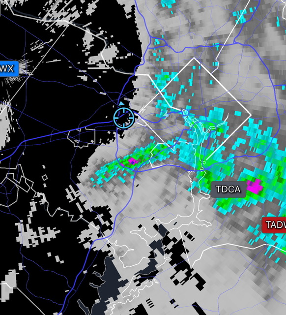
Random cell just sitting over Clinton MD
-
2024 Mid-Atlantic Garden, Lawn, and Other Green Stuff Thread
MN Transplant replied to mattie g's topic in Mid Atlantic
It was noticeably loud last night. -
1980 and 2010 were remarkably similar. Both ended up with 67 days of 90+. 1980 has 5 100s and 2010 had 4. The average high for the days that hit 90 were within a fraction of each other. In 2010 the heat started early with a couple of 90s in the first week of April, while in 1980 it stretched on with 14(!) 90+ days in September. 1980 did have the 21-day 90 streak which I believe still lives as the longest. Here's my disturbing heat stat, though. Only 4 years in the entire DCA climo record have had 4+ days where the total temperature (high + low) is 180, or a 90.0 average. 2011 2012 2016 2024
-
We have a heck of a model battle shaping up for Saturday. GFS - high in the low/mid 70s with clouds Euro - high in the upper 70s with some rain NAM - high in the upper 80s, mix of sun/clouds HRRR - high in the 90s with clouds and later day rain NWS is going low 80s with a chance of afternoon rain.
-
1.69” for the entire summer period so far. Sure could use some tropical remnants.
-
In my mind the humidity of 2011 still makes that one the king.
-
0.11”. The last time I’ve had more than a half inch of rain was in mid-May.
-
Relatively warm for the time period and wet. Average snow (20"). The prior three winters were cold and snowy.
-
DCA also went big that second week of July 1936. 104 and 105 on the 9th and 10th. That said the rest of the summer is unimpressive, including an amazing 60 degree high (!) on June 24th and 70s for highs multiple times at the end of July and early August. It really was a one hit wonder summer.
-
Both of them were at 100 on the 2:00pm 5-minute ob. BWI had also already cracked it earlier as seen in the 6 hour max. Amazing run here.
-
It’s funny that you’ve been beating me all summer, but the last two days I’ve passed you up. 99.9 here at the moment.
-
High so far are at least: DCA: 98 BWI: 97 IAD: 96 98.4 at home
-
Latest HRRR…is not a great convective model in weakly forced mid-Atlantic summer conditions
-
The 850s aren’t as supportive today, but DCA may grind out a 100 anyway.
-
Yesterday's average temp of 92.0 degrees (104/80) slots in as a tie for the 5th hottest day in the DCA climate record. NAME DATE TMAX TMIN Average T WASHINGTON REAGAN NATIONAL AIRPORT, VA US 7/7/2012 105 82 93.5 WASHINGTON REAGAN NATIONAL AIRPORT, VA US 7/23/2011 102 84 93.0 WASHINGTON REAGAN NATIONAL AIRPORT, VA US 7/6/1999 103 83 93.0 WASHINGTON REAGAN NATIONAL AIRPORT, VA US 7/22/2011 102 83 92.5 WASHINGTON REAGAN NATIONAL AIRPORT, VA US 7/29/2011 104 80 92.0 WASHINGTON DC WEATHER BUREAU CITY, MD US 8/6/1918 106 78 92.0
-
85 at 6am at DCA. Looks like the overnight low was 83.
-
95.2 at 2:19pm. From the solar measurements it looks like some clouds developed. DCA was similar.
-
Evidently it can only rain in Loudoun and MoCo now