

MN Transplant
-
Posts
17,847 -
Joined
-
Last visited
Content Type
Profiles
Blogs
Forums
American Weather
Media Demo
Store
Gallery
Everything posted by MN Transplant
-
One certainty is the we know how to treat this a lot better now. The virus is also infecting people that are healthier and able to fight it off. There is also the potential that virus as it is mutating and growing less deadly. These are all good things, and they were made possible by slowing the spread early on.
-
Just about 0.5" now. A dreary Sunday. Midnight high of 57 with a current temp of 45.
-
Maybe the last 75+ day? 77 at home.
-
Vikings are embracing the tank. Ngakoue gone, Hunter is officially out for the year, and DT Pierce had already opted-out. The remaining DL is full of backups or mid-or-late round rookies. I think Spielman has to go as GM. While he's done some good things, he's long been faulted for not being able to put together an OL or find a QB. But I think pretending like 2020 was a contending year and trying to rebuild on the fly will be his downfall. He extended Kirk's contract to buy some cap space and traded a 2nd (which sadly will be a high 2nd) for 6 games of Ngakoue. Now the Vikings are in cap hell and aren't even a good team. Thankfully Jefferson is fun to watch, otherwise this would be even more painful.
-
VA doesn’t actually have Teacher Unions like most people think of them. This is one of several “associations”, which looks like it accounts for 1/4 to 1/3 of the staff for Fairfax County. They definitely appear to be way out there on the cautious side, to an absurd extent.
-
6-9" across the Minneapolis metro region. Earliest 4"+ storm on record at MSP.
-
We're talking kids, not helicopter parents!
-
Had a great sunset/rainbow combo in Tyson’s.
-
Kids are resilient.
-
Disagree. Analytics says go for it. You need less than a yard and the game is over. The ball never touches Russ’s hands again.
-
Not that it would have mattered. Needed a better play call on 4th and 1 to win it.
-
0.67”
-
The thing is, the longer that we can delay “everyone” from getting it, the better chance that we’ll have: 1) better testing, 2) better treatment, 3) a useful vaccine. The President is already receiving treatment that wasn’t available months ago. It is also possible that the virus strain could weaken over time throughout its mutations. What we’ve been doing (distancing/masks/etc) hasn’t been a futile exercise. It is giving people a better shot going forward.
-
Bummed about that one. We were on the beach at OC and would have had a decent view.
-
BWI: 11/14 IAD: 10/25 DCA: 11/14 RIC: 11/14 TB: 84°
-
2020 Mid-Atlantic Severe Weather - General Thread
MN Transplant replied to Kmlwx's topic in Mid Atlantic
I’ve actually read the papers on this one. Effectively, they define a vector from the big raindrop region (Zdr) to the heavy precipitation region (Kdp). If the vector is closer to 90 degrees from storm motion, there is much more likely to be a tornado. The thought is that a narrower vector puts the Kdp region (negative buoyancy from the heavy rain) too close to the updraft. -
2020 Mid-Atlantic Severe Weather - General Thread
MN Transplant replied to Kmlwx's topic in Mid Atlantic
Boundary from the current storms is sitting just S of 66. -
2020 Mid-Atlantic Severe Weather - General Thread
MN Transplant replied to Kmlwx's topic in Mid Atlantic
It isn't really putting out the outflow boundaries that we see sometimes. Check out the clear air returns on radar. All our air is still coming from the S. -
2020 Mid-Atlantic Severe Weather - General Thread
MN Transplant replied to Kmlwx's topic in Mid Atlantic
We have to wait for the stuff back in WV. The 2nd round was always 7pm-ish. -
2020 Mid-Atlantic Severe Weather - General Thread
MN Transplant replied to Kmlwx's topic in Mid Atlantic
84.1 here just a bit west of you. Plenty of sun now, though it will cloud up for a period soon. Should be transient, though. -
2020 Mid-Atlantic Severe Weather - General Thread
MN Transplant replied to Kmlwx's topic in Mid Atlantic
In EJ's world, we only hit these if they are billion-dollar disasters. So, still due -
2020 Mid-Atlantic Severe Weather - General Thread
MN Transplant replied to Kmlwx's topic in Mid Atlantic
Quick hit by a bit of rain <0.10" and wind (~30mph). Some thunder. -
2020 Mid-Atlantic Severe Weather - General Thread
MN Transplant replied to Kmlwx's topic in Mid Atlantic
Storms firing along an outflow boundary from prior storms. A nice example. -
2020 Mid-Atlantic Severe Weather - General Thread
MN Transplant replied to Kmlwx's topic in Mid Atlantic
You both should have been in good shape unless va is more south than southeast. 2"+ widespread.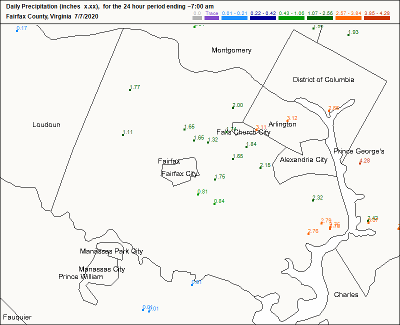
-
2020 Mid-Atlantic Severe Weather - General Thread
MN Transplant replied to Kmlwx's topic in Mid Atlantic
Booming again. Always turn the sprinkler on.


