MN Transplant
-
Posts
17,025 -
Joined
-
Last visited
Content Type
Profiles
Blogs
Forums
American Weather
Media Demo
Store
Gallery
Everything posted by MN Transplant
-
95/80/115 at home. Yeah
-
Pretty uniform 90/91 around the area at 10am.
-
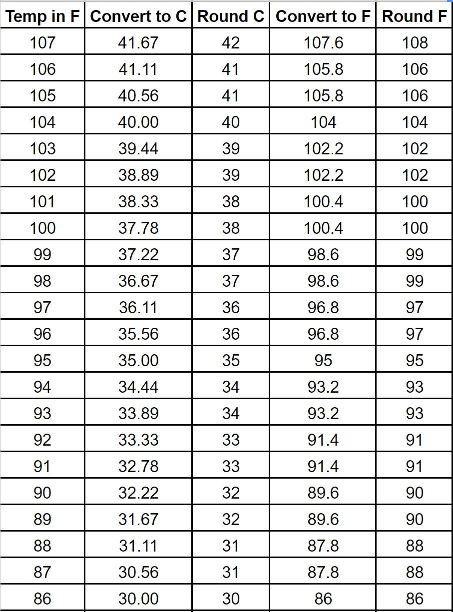
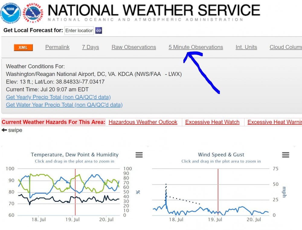
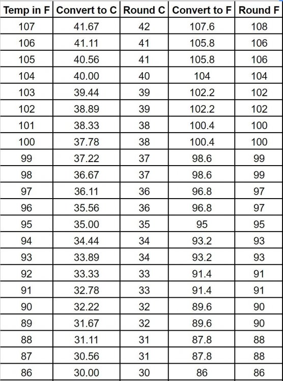
There has been a lot of confusion over the 5 minute observations from our main ASOS sites. I have absolutely no inside information on any of this, but I'm fairly certain I've figured out what is happening. Here is the link to DCA's obs: https://www.wrh.noaa.gov/mesowest/getobext.php?wfo=lwx&sid=KDCA&num=72&raw=0# That'll take you to the METARs, and below is how you get to the 5-min obs (you have to open a dropdown box on mobile). However, you have to be very careful with the 5 minute obs. What appears to happen is that the temperatures are initially communicated in rounded F degrees. They are then converted to C, but (and this is huge), the C degrees are rounded. Then they are converted back to F and rounded again! So, with the rounding, the temperature in F can be wrong by up to 1 degree. Here is a representation of the calculations and the reason why we don't see any 98s except for on the hourly obs. So, moral of the story for today is that a 99 could be a 99 or a 98. But 100 should be 100.
-
I have 99, 99, 98 for the three airports in the summer contest. I’m pretty comfortable with that.
-
Looks like 81 is the low at DCA. 79 here.
-
7-19 Severe outbreak MN into upper MI
MN Transplant replied to janetjanet998's topic in Lakes/Ohio Valley

-
7-19 Severe outbreak MN into upper MI
MN Transplant replied to janetjanet998's topic in Lakes/Ohio Valley
-
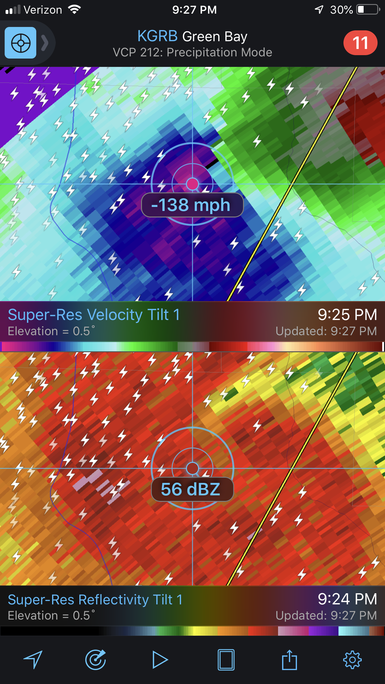
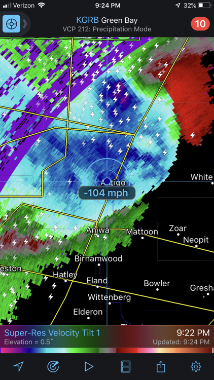
The velocities coming off the Green Bay Radar are insane. 110+
-
Think that may have been a bad ob. The big storms went north of there.
-
7-19 Severe outbreak MN into upper MI
MN Transplant replied to janetjanet998's topic in Lakes/Ohio Valley
-
DCA and IAD: 96 BWI: 97 Should add a few more tomorrow. Enough for 100? Will be close. Bonus ob: 95/81 on the 5 minute report from Minneapolis
-
It has been bouncing due to the river wind. Today has the classic markings of the first day of big heat. Warm air advection leading to temperatures staying near their peak well into the very late afternoon.
-
https://www.wrh.noaa.gov/mesowest/timeseries.php?wfo=fgz&sid=KDCA&num=72 select 5 minute observations. But beware, they are rounded from F to C to F, so they can be a degree off.
-
DCA’s point and click was 99, right? Above most guidance. They’ve been to at least 96 or 97. Not sure what math makes that 6 degrees.
-
Today wasn’t supposed to be the big heat day.
-
I realize that everyone knows relief is days away, but just to emphasize that point, in my hometown in southern MN it is 88/82 right now on the AWOS system. 94/80 here, for 113
-
DCA 95 IAD 96 BWI 98
-
I have 4 exterior thermometers (because shut up, that's why). 97.1, 96.5, 95.9, 94.6. The first three are shaded and the VP2 in the full sun is the lowest. Fan-aspirated shield working well.
-
95/78/111. Gross.
-
Hard to tell with the rounding, but DCA is something like 87/76 right now on a river wind. IAD appears to have ticked up to 91 already. My station is 92/79 for a 108 HI.
-
GFS is struggling with the urban heat island. Significant difference between DCA and IAD. The Euro- I don’t know. Edit - Saturday afternoon. Euro is 105ish, all the other globals are 98-101.
-
The dews don't look oppressive, so if we get the right downslope/mixing combo we might be able to do it. I didn't go to 100 in the summer contest precisely because of the wet conditions though, and I think LWS is right to keep the forecast in the upper 90s.
-
GFS is now 100/100/100/99 for Fri-Mon at DCA. Euro is 102/100/96/90
-
Fun 18z GFS run. Multiple 100s and then a remnant TS in fantasy land. Euro has begun the step down. Only 100 on Friday.
-
Euro 102, GFS 100 for Friday.