MN Transplant
-
Posts
17,025 -
Joined
-
Last visited
Content Type
Profiles
Blogs
Forums
American Weather
Media Demo
Store
Gallery
Everything posted by MN Transplant
-
2020 Mid-Atlantic Severe Weather - General Thread
MN Transplant replied to Kmlwx's topic in Mid Atlantic
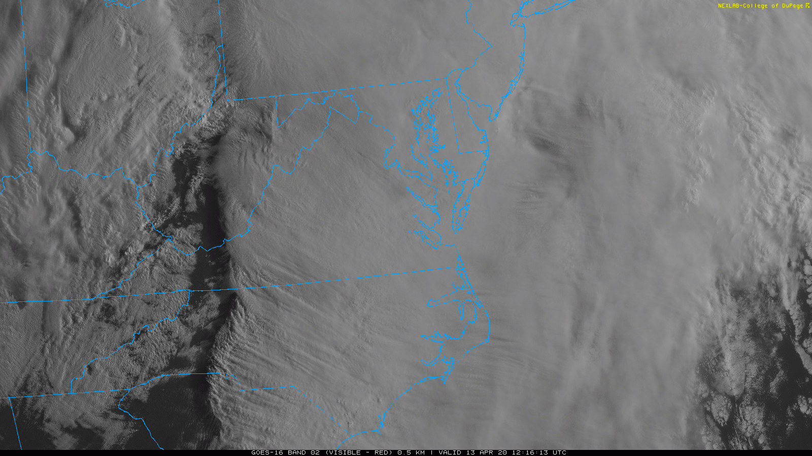
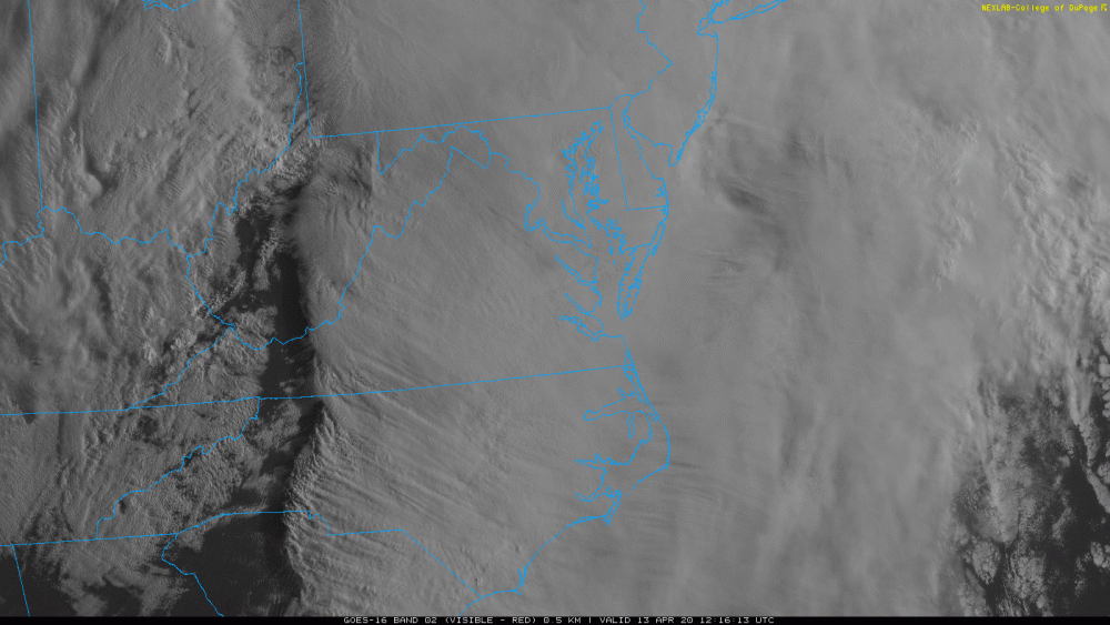
Not in the same way. The synoptic winds stayed elevated here. Any storms we get could mix down good winds, but that will be only in a scattered sense. The post-frontal wind should be breezy, but not anything special. -
2020 Mid-Atlantic Severe Weather - General Thread
MN Transplant replied to Kmlwx's topic in Mid Atlantic
That is a big watch box. edit for visual: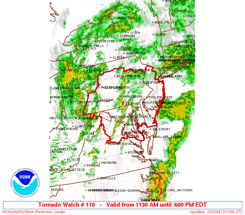
-
2020 Mid-Atlantic Severe Weather - General Thread
MN Transplant replied to Kmlwx's topic in Mid Atlantic
66.8 and steadily rising here. The NAM and Euro really busted on getting the winds to the surface this morning. I think the Icon was in better shape regarding that aspect. -
2020 Mid-Atlantic Severe Weather - General Thread
MN Transplant replied to Kmlwx's topic in Mid Atlantic
PRES HGHT TEMP DWPT RELH MIXR DRCT SKNT THTA THTE THTV hPa m C C % g/kg deg knot K K K ----------------------------------------------------------------------------- 1000.0 -12 927.0 654 17.0 -32.0 2 0.28 210 10 296.5 297.5 296.6 925.0 659 17.4 13.0 75 10.27 210 12 297.1 327.1 298.9 897.6 914 15.5 12.1 80 9.96 200 29 297.7 326.9 299.5 DP got screwed up and is affecting the calculations. -
2020 Mid-Atlantic Severe Weather - General Thread
MN Transplant replied to Kmlwx's topic in Mid Atlantic
Wallops has 68kts at 305m. Woosh. -
2020 Mid-Atlantic Severe Weather - General Thread
MN Transplant replied to Kmlwx's topic in Mid Atlantic
Not sure where LWX's is, but here is Blacksburg: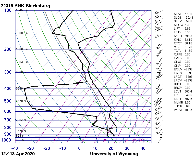
-
2020 Mid-Atlantic Severe Weather - General Thread
MN Transplant replied to Kmlwx's topic in Mid Atlantic
No kidding. I've been refreshing the Wyoming sounding site for a while now like an idiot because I forgot about the time change. Will be interesting to see IAD and Roanoke's. -
2020 Mid-Atlantic Severe Weather - General Thread
MN Transplant replied to Kmlwx's topic in Mid Atlantic
-
2020 Mid-Atlantic Severe Weather - General Thread
MN Transplant replied to Kmlwx's topic in Mid Atlantic
HRRR is handling the winds, and therefore the boundary layer, much better than the NAM to this point. Almost nothing has made it to the surface yet around DC. DCA's highest gust this morning is 23mph. Even the HRRR shows the gusts picking up by 10-11am, though, as we destabilize. ~1.6" so far here. -
2020 Mid-Atlantic Severe Weather - General Thread
MN Transplant replied to Kmlwx's topic in Mid Atlantic
Yup. Everyone should be charging their phones tonight. -
2020 Mid-Atlantic Severe Weather - General Thread
MN Transplant replied to Kmlwx's topic in Mid Atlantic
00z HRRR suggesting some isolated severe wind segments in the initial line that goes through early morning. 75+ mph -
2020 Mid-Atlantic Severe Weather - General Thread
MN Transplant replied to Kmlwx's topic in Mid Atlantic
No, this is an unusual wind setup for us. We get this serious southerly low level jet sometimes, but we generally have a boundary layer that prevents it from getting to the surface. This time there is all sorts of convection and the models think we’ll get it. Even the 18z HRRR which looks relatively unimpressive reflectivity-wise, gets gusts to ~60 mph. -
2020 Mid-Atlantic Severe Weather - General Thread
MN Transplant replied to Kmlwx's topic in Mid Atlantic
Yeah. What I’m assuming is that the euro and NAM are mixing down the big wind aloft during the line that comes through mid-to-late morning. So, not widespread and constant like March 2018. The euro then jacks up the CAPE following that line and has some semblance of storms in the early afternoon hours, but while the parameters are great, none of the models are throwing out any impressive storm signatures. Not sure why that is. -
2020 Mid-Atlantic Severe Weather - General Thread
MN Transplant replied to Kmlwx's topic in Mid Atlantic
12z euro still holds onto the widespread 60-70 mph gusts. -
2020 Mid-Atlantic Severe Weather - General Thread
MN Transplant replied to Kmlwx's topic in Mid Atlantic
The 3km NAM is so convoluted. You’ve got the warm front showers overnight, effectively ending by 8am. Then we get the leftover line of storms from MS/TN late morning. And after that the parameters peak and we got more storms firing early afternoon. That is a lot going on. -
2020 Mid-Atlantic Severe Weather - General Thread
MN Transplant replied to Kmlwx's topic in Mid Atlantic
-
2020 Mid-Atlantic Severe Weather - General Thread
MN Transplant replied to Kmlwx's topic in Mid Atlantic
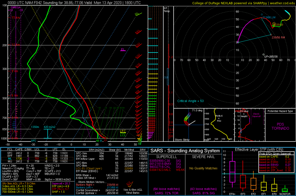
The 00z NAM sounding for 18z Monday has a PDS Tornado classification per Dupage. -
2020 Mid-Atlantic Severe Weather - General Thread
MN Transplant replied to Kmlwx's topic in Mid Atlantic
-
Going to be a nice one today. Low 60s, slight breeze. 50.5 after a low of 37.6
-
2020 Mid-Atlantic Severe Weather - General Thread
MN Transplant replied to Kmlwx's topic in Mid Atlantic
The Nest is in range now. The sim radar isn’t that interesting, probably because there are showers out front almost until initiation. However, the wind fields/sounding is wild. Wouldn’t take much to mix down (or spin up) something fun. -
2020 Mid-Atlantic Severe Weather - General Thread
MN Transplant replied to Kmlwx's topic in Mid Atlantic
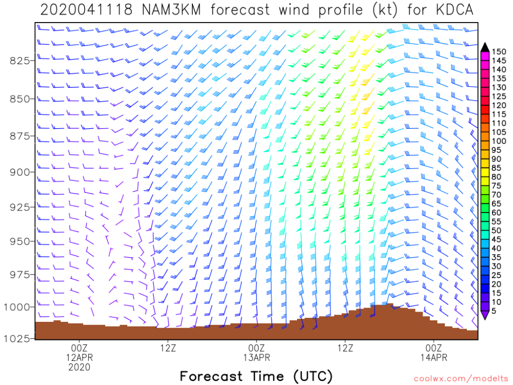
18z NAM had 70kt+ winds at 900mb on Monday morning. That is really windy, really close to the surface. -
Flurries. Top-10 winter event!
-
Might get a pre-midnight low tonight!
-
I went grocery shopping this afternoon. Between Giant and Safeway I was able to get everything on my list except yeast. Fleishmann's really has cornered that market and that is the only thing that has been absent every time. In my experience so far, Target and BJs have been re-upping the TP supply more often. I haven't seen any of that in the grocery stores.
-
2020 Mid-Atlantic Severe Weather - General Thread
MN Transplant replied to Kmlwx's topic in Mid Atlantic
Got a gust to 42 on my station, which probably means the actual was 45-50. Not bad. Very little rain with the overnight batch.