MN Transplant
-
Posts
17,026 -
Joined
-
Last visited
Content Type
Profiles
Blogs
Forums
American Weather
Media Demo
Store
Gallery
Everything posted by MN Transplant
-
Down to 70 at DCA. Lowest since June 26th.
-
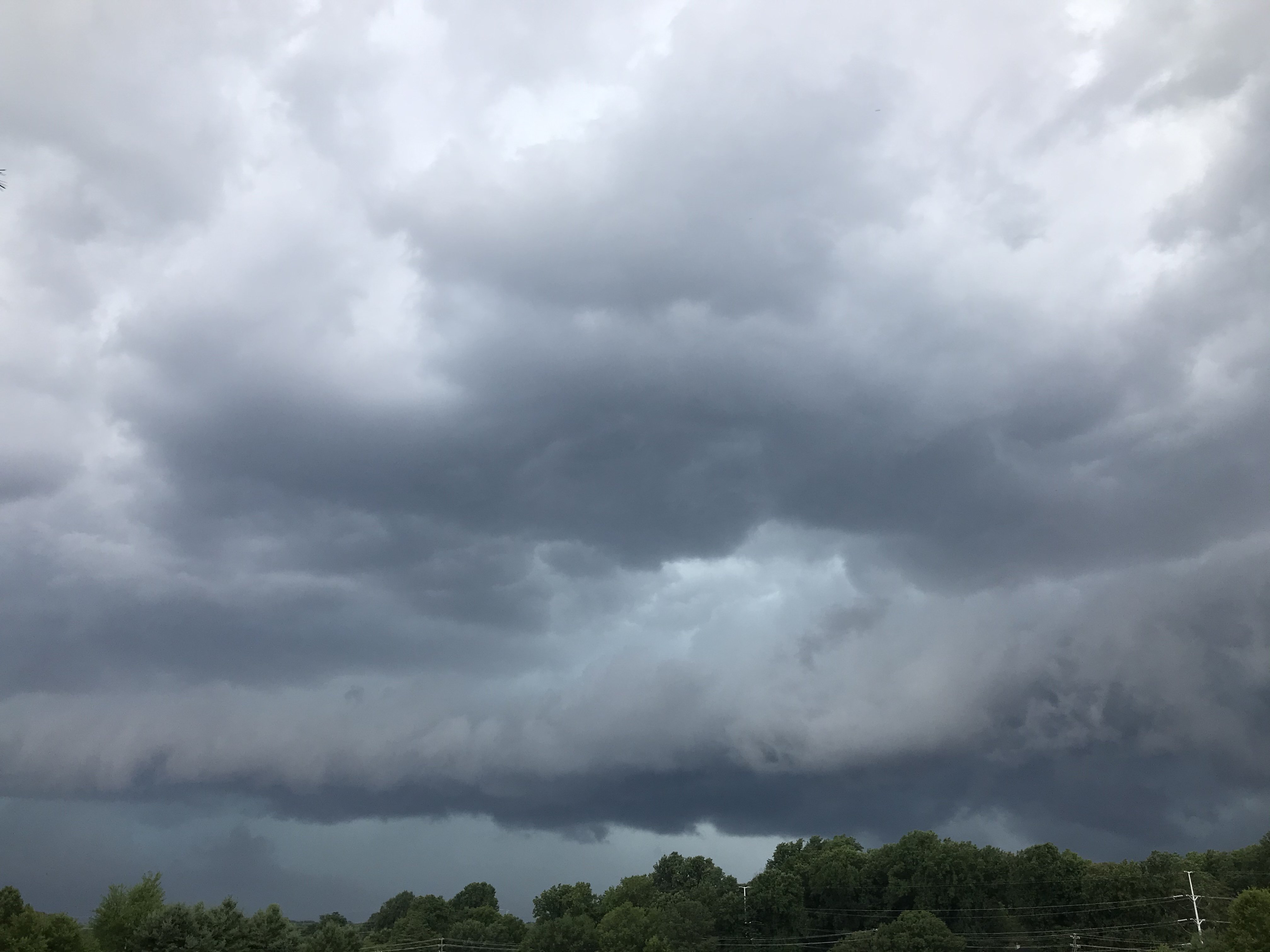
I think if I had a tall ladder I could touch that wall cloud.
-
2020 Mid-Atlantic Severe Weather - General Thread
MN Transplant replied to Kmlwx's topic in Mid Atlantic
Storms firing along an outflow boundary from prior storms. A nice example. -
Not just the HRRR. 18z NAM nest has 14" near Winchester. Certainly one of the odd situations where the models like the 81 corridor better for storms.
-
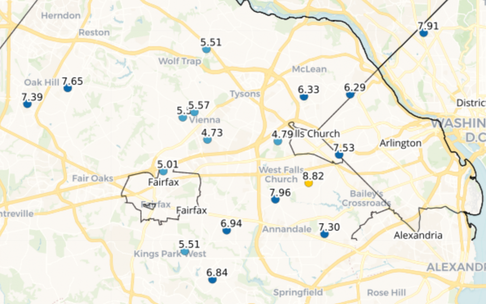
Now we can all see how much we've been screwed. That's me with the 4.79" in July.
-
Ha, you beat me by a few minutes! You can make a custom version up to 45 days. I've been waiting for something like this. https://maps.cocorahs.org/
-
Just popped in for the day over at Swallow Falls and Deep Creek State Park. Staying further East by Cumberland for a few nights. DCA post-frontal still has no problem getting to 90. This month just won’t stop.
-
90 at home. 78 here at Deep Creek. Elevation always wins!
-
I hit my breaking point today. Summer is the worst.
-
You all talking about the Os and I’m just sitting here enjoying Nelson Cruz going 4-5 with two bombas and 7 rbi. The dude is timeless.
-
90 already at DCA. That pretty much clinches the record for number of 90s in a month since the next three days look hot.
-
RadarScope is lit up like a Christmas Tree with lightning bolts. Still rumbling back here edit - stepped outside - it’s like a strobe light to my East. Jealous!
-
Mattie, Yoda, and H20 looking good again tonight
-
From Tuesday. This week is great. Raining and thunder again.
-
Still tracking for 3rd hottest all-time, even with the cool down at the end of the month. Day of Month Max Min Cumulative Average July 1-20 1860 1498 3358 84.0 Actuals Tuesday, July 21, 2020 21 97 76 3531 84.1 Actuals Wednesday, July 22, 2020 22 94 74 3699 84.1 Actuals Thursday, July 23, 2020 23 93 75 3867 84.1 NWS Forecast Friday, July 24, 2020 24 89 74 4030 84.0 NWS Forecast Saturday, July 25, 2020 25 91 73 4194 83.9 NWS Forecast Sunday, July 26, 2020 26 95 74 4363 83.9 NWS Forecast Monday, July 27, 2020 27 96 76 4535 84.0 NWS Forecast Tuesday, July 28, 2020 28 94 78 4707 84.1 NWS Forecast Wednesday, July 29, 2020 29 90 75 4872 84.0 GFS/Euro blend Thursday, July 30, 2020 30 82.5 73.5 5028 83.8 GFS/Euro blend Friday, July 31, 2020 31 81 70.5 5179.5 83.5 GFS/Euro blend 90 degree days - current 21 July 2011 84.5 90 degree days - forecast 27 July 2012 84.0 90 degree day - record 25 July 2010 83.1 July 1993 83.1 July 1999 83.0
-
In the Fairfax seven-hour School Board meeting the Superintendent kept talking about how a decent percentage of teachers were from another county, so their decisions affect the plans. It does end up being a regional-type decision.
-
1.70" for the past three days, which I'm very happy about. But ~3 miles away they are sitting at 4.5", so a little jealous.
-
93.6 to 71.4, so the same 22 degrees. I cracked my window to listen to the storm and now I've left it open.
-
Approaching an inch and ~1.6" for the past three days. Sorely needed.
-
DCA got the severe criteria. G to 58
-
Wind didn't really deliver here, but the pounding rain and nearby CGs are fun.
-
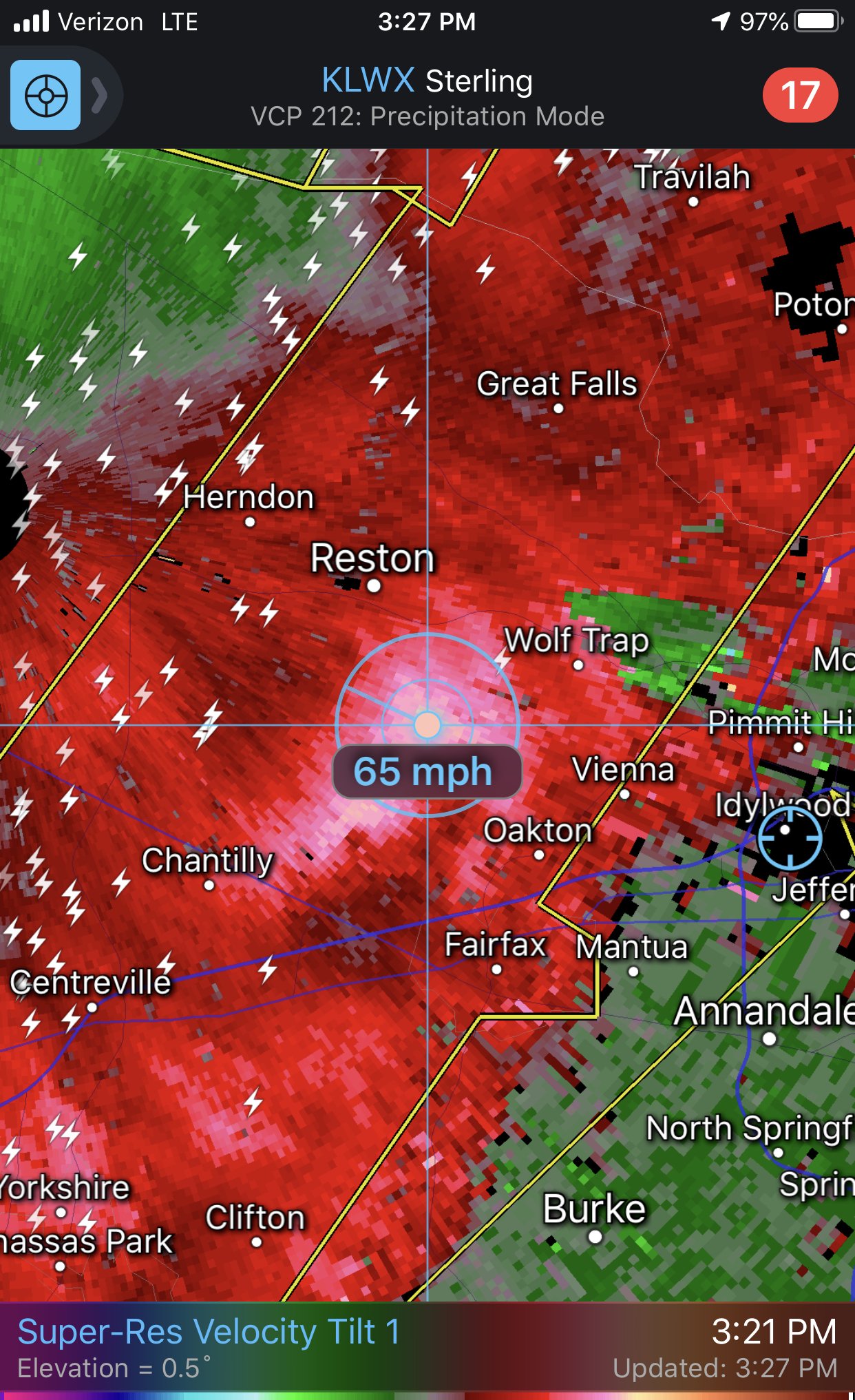
Not unhappy with the radar right now. Headed outside to take a look.
-
LWX is giving out warnings like candy