MN Transplant
-
Posts
17,071 -
Joined
-
Last visited
About MN Transplant

-
Nice I68 storm
-
Feels nice today, though
-
The HRRR is extremely aggressive with winds in any convection that develops this afternoon.
-
Spectacular, except this is the first day I've noticed bugs.
-
They got rain the day prior from the broader trough but not the low itself.
-
Mostly unimpressive except for two locations and two individual events. The early-season SE Colorado event and then the absurd Gulf Cost event.
-
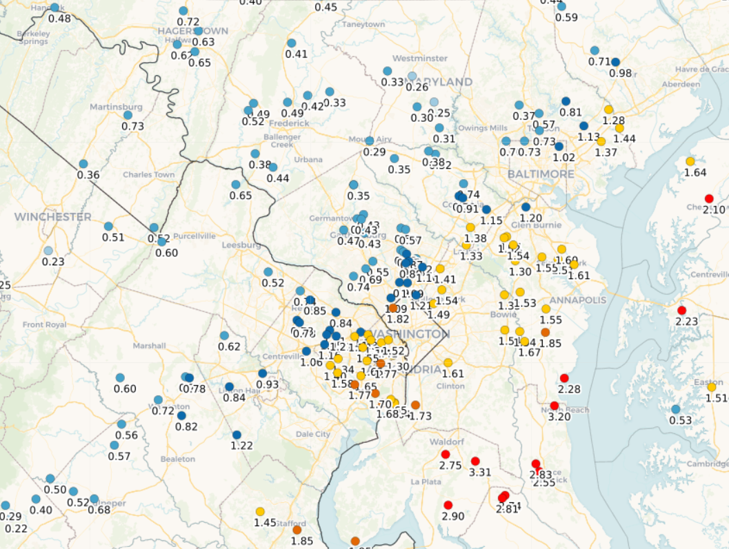
Quite the gradient (2 day totals)
-
Yeah, I’m dancing on the edge right now. 0.38”
-
12z HRRR looks great. Even throws 0.5” back to Winchester.
-
The problem is that this is a small low and the moisture availability is modest at best. PWATs don’t even get close to 1”. Part of the reason why this looked like a region-wide soaker from several days back was that the two parts (wave then low) nicely hit different areas. The wave part ended up being a dud for most of us except for up by Hagerstown. I got a trace.
-
18z NAMs and HRRR look fine. Most of us over an inch, and up to 2"+ in lucky spots. The difference is that the HRRR centers the precip in the center and east of the DC/Balt region, while the NAMs favor spots W of 95.
-
Low of 30.0, which is impressive. I didn’t think my spot had another freeze in it. Downtown DC and DCA avoided freeze, as did Annapolis.
-
34 this morning. I’m skeptical of a freeze tomorrow in the warmer spots (DCA, local elevated areas), but the regular spots should get there.
-
The 4"+ on the Euro would be kind of fun.
-
The pollen puddles were unreal this morning. About 0.4”