

Ahoff
-
Posts
2,621 -
Joined
-
Last visited
Content Type
Profiles
Blogs
Forums
American Weather
Media Demo
Store
Gallery
Everything posted by Ahoff
-
Pittsburgh, Pa Summer 2024 Thread.
Ahoff replied to meatwad's topic in Upstate New York/Pennsylvania
Also, this doesn’t look all that impressive for the east Coast either. I wasn’t seeing so many 100s in the forecast for areas that often hit that number. -
Pittsburgh, Pa Summer 2024 Thread.
Ahoff replied to meatwad's topic in Upstate New York/Pennsylvania
I did wonder if at some point during this “historic” heat wave if we would miss 90 at least once. Today could be the day. More sun out now, so could make one final push, but we don’t do well with that kind of surge. 5 minute obs do say 90 right now, but that could obviously mean 89. Still have a little heating to go possibly. But the Excessive Heat Warning probably needs to go. Heat advisory should be sufficient for rest of the week. -
Pittsburgh, Pa Summer 2024 Thread.
Ahoff replied to meatwad's topic in Upstate New York/Pennsylvania
Might actually be a struggle to 90 today. Cloud cover is pretty thick. Strong ridges don't do a whole lot for our area, lol. Yeah, really cloudy out there, fairly dark clouds too. What is the reasoning behind so many clouds with a supposedly historically strong ridge? Can’t be only humidity levels, we’ve had very humid days with plenty of sun. Feels like there’s been more clouds than sun this week. This is kind of a busted forecast from the NWS from just a few days ago. -
Pittsburgh, Pa Summer 2024 Thread.
Ahoff replied to meatwad's topic in Upstate New York/Pennsylvania
Ok, that makes sense. I always wondered why there was a discrepancy, thanks. -
Pittsburgh, Pa Summer 2024 Thread.
Ahoff replied to meatwad's topic in Upstate New York/Pennsylvania
Yeah, the excessive heat warning is a head scratcher, unless they believe we’ll get there later in the week. -
Pittsburgh, Pa Summer 2024 Thread.
Ahoff replied to meatwad's topic in Upstate New York/Pennsylvania
Another question I had that I’ve noticed. The official observations (like at 7:51, 8:51, etc) seem weird from all the obs around that time. An example is today at each official observation had overcast as the sky cover, but the 5 minute obs never recorded overcast all morning. Why throw it in if they aren’t observing it. They do it with temp too. It will read a certain temp at the times before the official and they’ll drop it, then a few minutes later it goes right back up. what’s the reason for that? -
Pittsburgh, Pa Summer 2024 Thread.
Ahoff replied to meatwad's topic in Upstate New York/Pennsylvania
Stand to reason we’ll easily get to 90. We’ll see how high we get again. -
Pittsburgh, Pa Summer 2024 Thread.
Ahoff replied to meatwad's topic in Upstate New York/Pennsylvania
Wow KPIT, on the 5 min obs jumped to 81 at 8:30am. -
Pittsburgh, Pa Summer 2024 Thread.
Ahoff replied to meatwad's topic in Upstate New York/Pennsylvania
Must have dissipated, got sunny and was showering at the same time. That was the extent here. Thank goodness. -
Pittsburgh, Pa Summer 2024 Thread.
Ahoff replied to meatwad's topic in Upstate New York/Pennsylvania
Lol, our totally dry week from last week's forecast, now has a chance of rain every day through the weekend now. Also, CPC has slight risk of excessive heat for 6/29-7/2. Reload. -
Pittsburgh, Pa Summer 2024 Thread.
Ahoff replied to meatwad's topic in Upstate New York/Pennsylvania
Getting a bit windy here, and dark. Hopefully, no power loss. -
Pittsburgh, Pa Summer 2024 Thread.
Ahoff replied to meatwad's topic in Upstate New York/Pennsylvania
Sure, they were hyping all time June records. It’s be neat to get that, but realistically I knew that was unlikely. So, there isn’t any complaint here, lol. Might still be able to sneak a 95 or 96 later in the week. Though, if we had that higher heat we likely wouldn’t be having the storms. Seems they are coming from the other direction today. -
Pittsburgh, Pa Summer 2024 Thread.
Ahoff replied to meatwad's topic in Upstate New York/Pennsylvania
Honestly, I won’t respond to a certain very sensitive poster, but was there a complaint in my post? I stated a fact and then made an observation. I’m not bothered by it at all. Humidity is definitely the culprit from the rain yesterday. This certainly isn’t going to ruin my day like snow does for someone, but it’s just interesting. 90 looks locked today, just a question of how high it goes. Also, I wonder if that hazy layer will actually help keep storms down today? Maybe without the most direct sun it keeps it a bit more stable. -
Pittsburgh, Pa Summer 2024 Thread.
Ahoff replied to meatwad's topic in Upstate New York/Pennsylvania
Lagging behind yesterday’s temps by 2 degrees. Clear most locations except KPIT, lol. They have a knack. -
Pittsburgh, Pa Summer 2024 Thread.
Ahoff replied to meatwad's topic in Upstate New York/Pennsylvania
I don’t know, we seem to be one of the few places where a stronger ridge does not mean less rain, lol. Ron Smiley just said storms should be firing by 2pm. If they do hit then no way it’s as warm as expected. -
Pittsburgh, Pa Summer 2024 Thread.
Ahoff replied to meatwad's topic in Upstate New York/Pennsylvania
Lol. Well, if it was hyped as historic I'd like to see historic. They always get out ahead of their skis, and look foolish afterward. There is still a possibility toward the end of the week for very high temps, but once the adjustments down start, they rarely stop. Kind of like snowstorms, lol. -
Pittsburgh, Pa Summer 2024 Thread.
Ahoff replied to meatwad's topic in Upstate New York/Pennsylvania
Forecast is slipping down. Not looking historic now. They’re introducing rain into the forecasts. That’s the killer, lol. Maybe we’ll get a few low 90s and one or two days at 95 at most. -
Pittsburgh, Pa Summer 2024 Thread.
Ahoff replied to meatwad's topic in Upstate New York/Pennsylvania
NWS is starting to come back down to more reasonable temps. Look a couple degrees off each day. -
Pittsburgh, Pa Summer 2024 Thread.
Ahoff replied to meatwad's topic in Upstate New York/Pennsylvania
Interesting they’d use downtown as the temperature not the official at the airport. -
Pittsburgh, Pa Summer 2024 Thread.
Ahoff replied to meatwad's topic in Upstate New York/Pennsylvania
Here's the forecast for KPIT.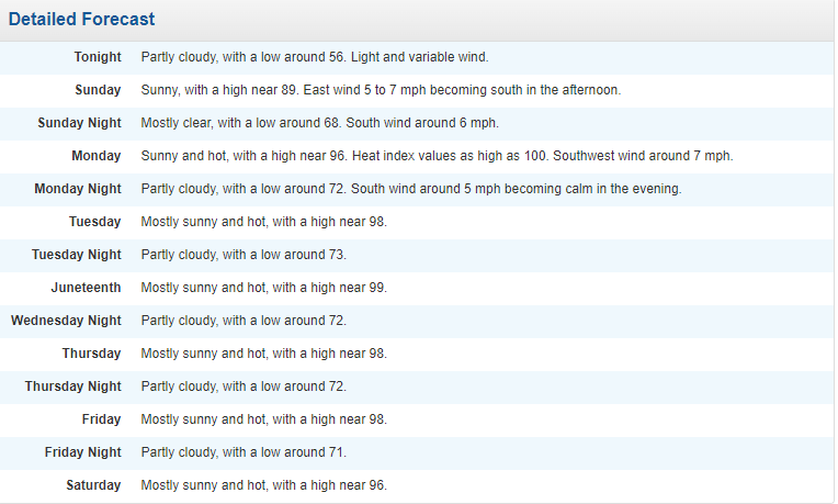
-
Pittsburgh, Pa Summer 2024 Thread.
Ahoff replied to meatwad's topic in Upstate New York/Pennsylvania
Just seems the high may be setting up perfectly (or imperfectly depending on how you look at it) for us to maximize on the potential. We’ll see if this was overhyped or not by this time next week. -
Pittsburgh, Pa Summer 2024 Thread.
Ahoff replied to meatwad's topic in Upstate New York/Pennsylvania
I’d be surprised if we’re totally clouded with the high being pretty nearly over us. Maybe a few clouds, but couldn’t imagine total cover. Or maybe they’d be those high thin clouds that still let the sun through, but a little more filtered. NWS not too interested in widespread cloudiness, though they do mentione how it could happen, but say that possibility remains pretty low for now. -
Pittsburgh, Pa Summer 2024 Thread.
Ahoff replied to meatwad's topic in Upstate New York/Pennsylvania
Oh, certainly don’t remember that one. Probably downgraded to Heat Advisory. Edit: Oh, I do remember this. This was the last day of my parish's festival, the dew point touched 80 that day. Never felt humidity like that here. High was only 90, but with a dew point that high, it was brutal. -
Pittsburgh, Pa Summer 2024 Thread.
Ahoff replied to meatwad's topic in Upstate New York/Pennsylvania
Wonder when the last time we had and excessive heat watch or warning was? 2012? -
Pittsburgh, Pa Summer 2024 Thread.
Ahoff replied to meatwad's topic in Upstate New York/Pennsylvania
NWS still hanging on. They now have that very elusive 100 degree temperature forecast for Wednesday. If we do get that close, might as well hit it. End that drought.


