

Modfan2
-
Posts
2,833 -
Joined
-
Last visited
Content Type
Profiles
Blogs
Forums
American Weather
Media Demo
Store
Gallery
Everything posted by Modfan2
-
I think this will end up between Venice and Sarasota
-
Where?
-
Tropical Storm warnings expanded here in SE FL
-
Under a Tropical Storm warning now in SE FL.
-
Nice plot Ray; while at this moment I am too far east (pretty much on the I 95 sign above Palm Beach) for any major impacts other than rain and some breezy weather at this point.
-
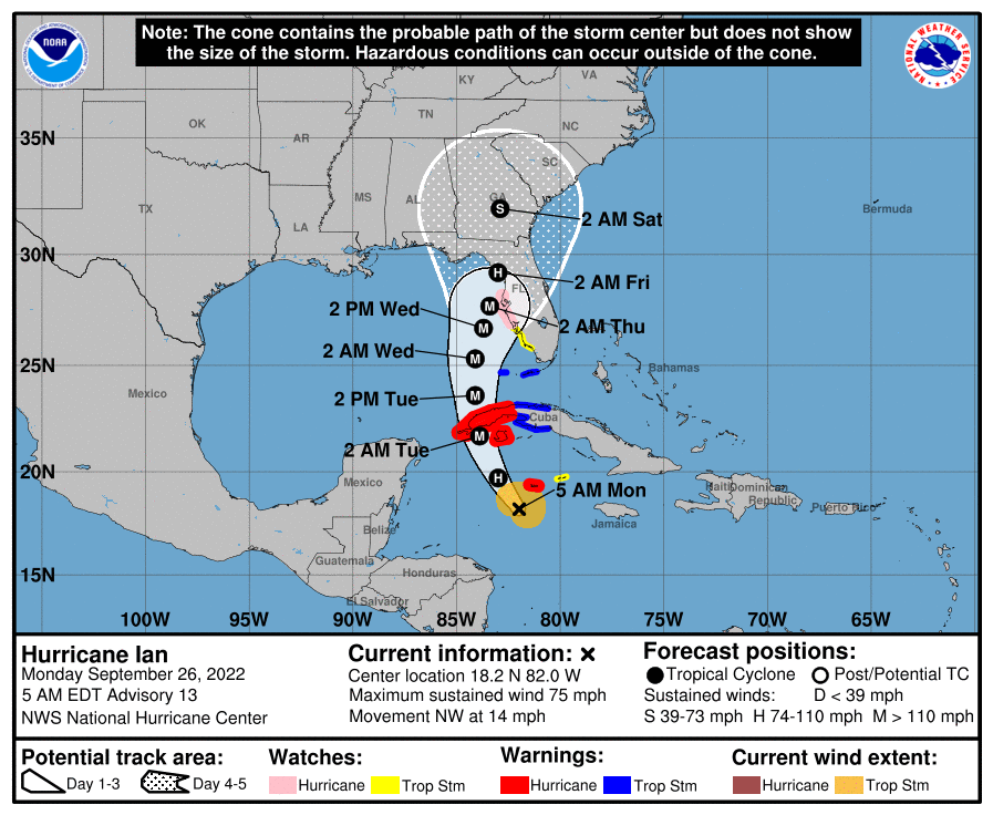
5am cone from NHC
-
During Irma parts of St Lucie County and neighboring Indian River counties received 21” and there was quite a bit of flooding.
-
Plenty of members show a Tampa area hit, not sure I would call that “wishcasting”. Nothing is off the table at this point.
-
Most all models except GFS are around Tampa area
-
5am cone from NHC, S FL currently out of the cone; this can change.
-
Would a slower development mean a more westerly track into the Gulf?
-
Hope so, don’t want any part of it; a Tampa north LF is fine by me!!
-
I would think, at this point that is the outlier?
-
5am track
-
I mean why wouldn’t it, I close down here in 2 weeks and the few days later in CT….FML!
-
Seems the quicker the right turn the weaker it is…
-
If it does I assume a further west track?
-
Is this due to the 2 centers of circulation, picking the further Sw as the main center?
-
Is the thinking still Sw to Ne on track where ever it makes landfall?
-
Wasn’t the Ukie the one that nailed the Irma track?
-
I would think we would need to see some model consistency over the next few runs to see the if this is a trend.
-
Thinking your second scenario is more likely.
-
 Nice line in E Ct
 -
I’m good with that, I close down here on the 7th and that the last thing I need!
-
There were quite a few members taking this into the Yucatán
