Duca892
-
Posts
274 -
Joined
-
Last visited
Content Type
Profiles
Blogs
Forums
American Weather
Media Demo
Store
Gallery
Everything posted by Duca892
-
Sunday 1/19 Eagles Game Snow and Stuff
Duca892 replied to Ralph Wiggum's topic in Philadelphia Region
Feel like this is a lock for a nice 5-8in snow for places like the Lehigh Valley. Will be a nice little snowstorm -
Sunday 1/19 Eagles Game Snow and Stuff
Duca892 replied to Ralph Wiggum's topic in Philadelphia Region
RGEM continues 10-11in paste job for some places lol -
Sunday 1/19 Eagles Game Snow and Stuff
Duca892 replied to Ralph Wiggum's topic in Philadelphia Region
Winter Storm Watch issued for 5-8in in the Lehigh Valley -
Sunday 1/19 Eagles Game Snow and Stuff
Duca892 replied to Ralph Wiggum's topic in Philadelphia Region
I have lived in whitehall/bethlehem/allentown my 32yrs on Earth, and I just had to look at a map to tell if I lived North or South of I-78 -
Sunday 1/19 Eagles Game Snow and Stuff
Duca892 replied to Ralph Wiggum's topic in Philadelphia Region
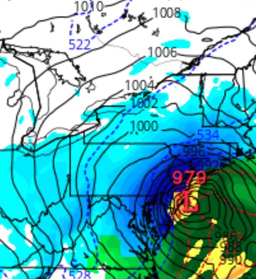
That is an absolute beaut -
Sunday 1/19 Eagles Game Snow and Stuff
Duca892 replied to Ralph Wiggum's topic in Philadelphia Region
Yea the RGEM can tick S/E, goes from about 8in in Allentown to like 1in in Quakertown in a difference of like 30mi lol -
Sunday 1/19 Eagles Game Snow and Stuff
Duca892 replied to Ralph Wiggum's topic in Philadelphia Region
NAM getting something together is making me breathe a sigh of relief, would of been so pissed if it scored a coup lmfao -
Sunday 1/19 Eagles Game Snow and Stuff
Duca892 replied to Ralph Wiggum's topic in Philadelphia Region
My expectation or at least the way it appears to go is that a model like the 6z GFS likely “capped” out its snow amounts and will “correct” back down a bit. Where if it’s 40% of where it was at 6z we end up with like 5-6in for many lol -
Sunday 1/19 Eagles Game Snow and Stuff
Duca892 replied to Ralph Wiggum's topic in Philadelphia Region
I’m a big lover of the “Winter Storm Warning” vs “Advisory” and if this can hold the Lehigh Valley area might get its first Warning of the year. To be seen -
Sunday 1/19 Eagles Game Snow and Stuff
Duca892 replied to Ralph Wiggum's topic in Philadelphia Region
6z GFS just casually dropping 8-10in of snow for most -
Sunday 1/19 Eagles Game Snow and Stuff
Duca892 replied to Ralph Wiggum's topic in Philadelphia Region
Almost like universally 2-5in for many across the board. Well… aside from NAM -
GFS with a nice 4-6in swath for many
-
Hope the EURO doesn’t start a trend for Sunday. I was pleasantly surprised to see the GFS jump on board for a solid 4-6in snowfall for many
-
Hell back to another 190+ hours out crush job by the GFS this morning for next week.
-
Feels like this is the winter for suppression depression
-
Bone dry and numbingly cold. My favorite combo!
-
-
We aren’t going to get Jack shit other than nickel and dime events are we…
-
I’m riding the bus to 2.6in
-
Allentown from 1.7 to 2.1 to 2.2in. on the 6z>12z>18z GFS. Moving on up baby!!!
-
Up to 2.1 in Allentown from 1.7 at 6z. Let’s go!!!!
-
Idk anything other than forum browsing, but I feel 4-5 days out that it might be in an amazing spot IF it trends N/W on the 6z GFS?
-
Any progress steps at least? Lol.
-
Still there on GFS. Please kick out East more thanks lmfao
-
This needs to be framed for when it disappears