

Baltimorewx
-
Posts
2,227 -
Joined
-
Last visited
Content Type
Profiles
Blogs
Forums
American Weather
Media Demo
Store
Gallery
Everything posted by Baltimorewx
-
Late January and February Medium/Long Range Discussion
Baltimorewx replied to WinterWxLuvr's topic in Mid Atlantic
ICON took a step back if anyone cares about it. Cold press a little slower, track a little more inland -
Late January and February Medium/Long Range Discussion
Baltimorewx replied to WinterWxLuvr's topic in Mid Atlantic
Seems slightly faster with the cold push but not significantly so.- 4,130 replies
-
- 1
-

-
- prime climo
- cold canada
- (and 1 more)
-
Late January and February Medium/Long Range Discussion
Baltimorewx replied to WinterWxLuvr's topic in Mid Atlantic
18z euro I guess was slightly faster with the cold press but not by a lot and it’s still pretty much rain for all at hour 90 except for far western MD and right along the PA line near Hagerstown -
Late January and February Medium/Long Range Discussion
Baltimorewx replied to WinterWxLuvr's topic in Mid Atlantic
I don’t see many major differences in the 18z euro compared to 12z thru 60 -
Late January and February Medium/Long Range Discussion
Baltimorewx replied to WinterWxLuvr's topic in Mid Atlantic
I mean I dont care about the ICON much but it is colder if you look at temps compared to 12z- 4,130 replies
-
- 1
-

-
- prime climo
- cold canada
- (and 1 more)
-
January 28-29 2022 Miller abcdefu Storm Obs/Discussion
Baltimorewx replied to mappy's topic in Mid Atlantic
Castle in the snow!…here is the wintry scene in Ocean City Maryland this morning at the Castle in the Sand hotel and beach bar. Go here at least a dozen times a summer. Kind of regretting not chasing and staying at my family’s house this weekend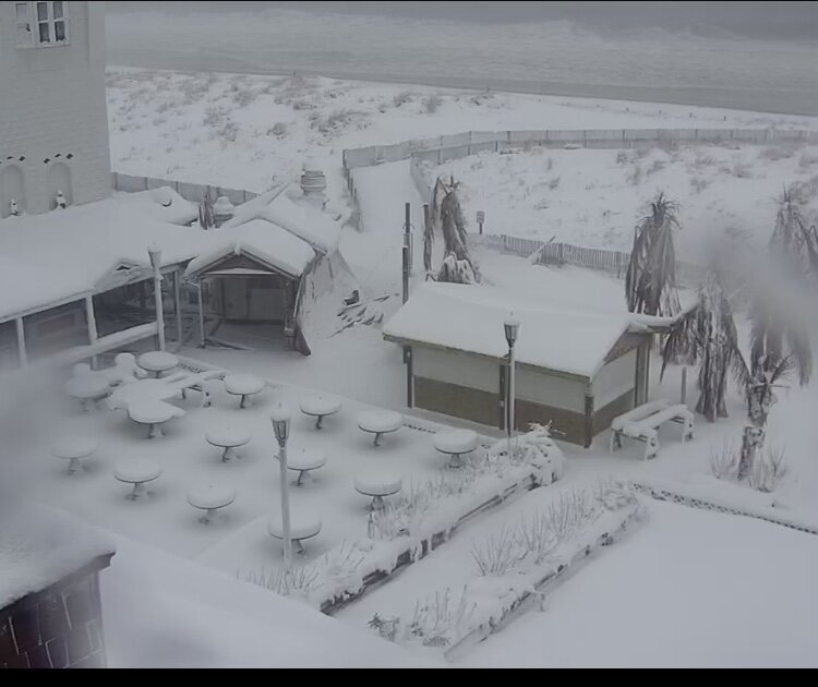
-
January 28-29 2022 Miller abcdefu Storm Obs/Discussion
Baltimorewx replied to mappy's topic in Mid Atlantic
I thought he chased by maybe I’m wrong -
January 28-29 2022 Miller abcdefu Storm Obs/Discussion
Baltimorewx replied to mappy's topic in Mid Atlantic
Looks like it’s wrapping up here in Dundalk. I’d say 2-2.5”. Street is clear but it was probably salted. Sidewalk somewhat completely covered but can see pavement in spots. While it it snowed lightly for a long time, it was just a bit disappointing that never really saw that one good band. OC looks like it’s getting ripped on right now though -
January 28-29 2022 Miller abcdefu Storm Obs/Discussion
Baltimorewx replied to mappy's topic in Mid Atlantic
Nice. My parents live in west OC off route 611 -
January 28-29 2022 Miller abcdefu Storm Obs/Discussion
Baltimorewx replied to mappy's topic in Mid Atlantic
Where in OC are ya? -
January 28-29 2022 Miller abcdefu Storm Obs/Discussion
Baltimorewx replied to mappy's topic in Mid Atlantic
Finally getting a little bit better snow now here in Dundalk under those light green bands. Pavement finally beginning to cave in spots. Probably close to 1” on the grass -
January 28-29 2022 Miller abcdefu Storm Obs/Discussion
Baltimorewx replied to mappy's topic in Mid Atlantic
Unfortunately I don’t see any results from it yet…still just very light pixie dust -
January 28-29 2022 Miller abcdefu Storm Obs/Discussion
Baltimorewx replied to mappy's topic in Mid Atlantic
Too bad we don’t have any folks here in Cambridge…should be absolutely ripping there right now -
January 28-29 2022 Miller abcdefu Storm Obs/Discussion
Baltimorewx replied to mappy's topic in Mid Atlantic
Yes, it’s started as rain in OC but as the coastal cranks, it’ll quickly turn to snow. So it’s not a big deal -
January 28-29 2022 Miller abcdefu Storm Obs/Discussion
Baltimorewx replied to mappy's topic in Mid Atlantic
It’s not a heck of an event there it’s just that fact that it’s elevated and it’s colder so those wet roads turned icy over the light slick snow covering. Sometimes a dusting of light icy snow is worse than a few inches on the road -
January 28-29 2022 Miller abcdefu Storm Obs/Discussion
Baltimorewx replied to mappy's topic in Mid Atlantic
Trying to trust the modeling but radar doesn’t look great up here in Baltimore..things just don’t seem to be expanding in. -
January 28-29 2022 Miller abcdefu Storm Obs/Discussion
Baltimorewx replied to mappy's topic in Mid Atlantic
I'm not Millville but it sounds about right to me.... -
January 28-29 2022 Miller abcdefu Storm Obs/Discussion
Baltimorewx replied to mappy's topic in Mid Atlantic
Its early...I mean its not going to be a full blown snowstorm but radar will look a little better in a couple hours. Not really supposed to get accumulation until 7ish anyway -
January 28-29 2022 Miller abcdefu Storm Obs/Discussion
Baltimorewx replied to mappy's topic in Mid Atlantic
Yeah even the 12K is backing down. I mean it makes sense with the set up. That back edge is just gonna be painful to watch -
January 28-29 2022 Miller abcdefu Storm Obs/Discussion
Baltimorewx replied to mappy's topic in Mid Atlantic
Short range models seem to be ticking east a bit with the coastal precip shield. Not a whole lot west of the bay on most of them right now. Ah well, its gametime. We'll see how it rides. -
January 28-29 2022 Miller abcdefu Storm Obs/Discussion
Baltimorewx replied to mappy's topic in Mid Atlantic
Should I mean everything points to at least 1"...Id say 1" this evening then maybe another 1-2" overnight into mid morning with the coastal back edge -
January 28-29 2022 Miller abcdefu Storm Obs/Discussion
Baltimorewx replied to mappy's topic in Mid Atlantic
Yeah I really think that back edge is really gonna mainly set up right along the bay. Itll be so close yet so far! -
January 28-29 2022 Miller abcdefu Storm Obs/Discussion
Baltimorewx replied to mappy's topic in Mid Atlantic
Slight shift west in the 6z Euro. Not super sizeable but gets me just over 2” lol -
January 28-29, 2022 Miller abcdefu Storm Threat
Baltimorewx replied to WxUSAF's topic in Mid Atlantic
Weird they didnt issue it for southern Baltimore county. I guess the snow goes from Glen Burnie skips Dundalk and goes to Aberdeen -
January 28-29, 2022 Miller abcdefu Storm Threat
Baltimorewx replied to WxUSAF's topic in Mid Atlantic
GFS aint awful...little better with the Fri Eve stuff...1-2" maybe 3" in spots
