

Baltimorewx
-
Posts
2,227 -
Joined
-
Last visited
About Baltimorewx

Recent Profile Visitors
2,786 profile views


-
Ah yeah. Damn. I forgot
-
Does it do anything a little later in the run? The EURO AI didn’t really develop a surface low until 150-156. Just curious
-
Well for what it’s worth the 18z Euro AI was a step towards a storm…just a lot slower in developing and still too far south though
-
Seems like the GFS wants to over-phase things this winter…Canadian and Euro aren’t even close to this kind of solution. I have to root against it this time. Have a cruise out of Cape Liberty Sunday. If the GFS is near close to right, the drive up would be challenging and sailing down the coast Sunday night would be rocky as hell.
-
A lot of modeling had the accumulated precip west of the metros though. But let’s be real, they issued it as a cover your ass advisory because it was potentially close to rush hour. If it was something that was overnight, it likely would not have been issued. Having said that, in my opinion, one of those special weather statements saying “a potential hazardous weather situation has a 30-50% chance of materializing” things would have been more appropriate for this case. Nothing was really showing up to 1” potential.
-
Why they even have wording for up to 1” is kind of mind boggling. Maybe we will be surprised but my bar is seeing a few flurries and my top expectation is a dusting at best.
-
Too bad nobody is getting 1”. It’s a cover your ass advisory
-
I’m being more facetious than anything. But with these schools these days you never know
-
Closed. Even though there will probably be more flakes coming out of my hair than the sky!
-
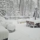
Not really sure what radar you’re looking at. It’s basically a mess with intermittent returns. No real solid shield or steady consistent snow on the north end north of the main area of heavy precip near the low down in FL/GA. It’s clear the cold press and dry air is just tearing apart what could have been a solid precipitation shield on the north end. Radar sucks. The only thing that’s saving it for parts of Central VA is that it is this cold so instant stickage. Once the coastal gets going there will finally be a consolidated area of darker greens and a deform area but that’s going to be a pretty small area in SE VA and NE NC
-
Seems legit but a little weary of super huge numbers. Pattern has been progressive, not sure it’s a slow enough mover for 18+. But seems like we all could score a 12-18” incher, the no worries about temps definitely helps
-
Nah I’m like the groundhog. After last night, saw my shadow. 6 more weeks of hibernation
-
We are like 70. Had reservations for 5pm. Home and done dinner before 7
-
Don’t any of yall have girlfriends or wives to take to dinner? Bunch of weenies in here tonight. The NAVGEM isn’t on board so I’m out
-
You can pretty much tell based on radar orientation that the line between steadier heavier snow and lighter intermittent snows is gonna set up somewhere right along the fall line. Which is generally what models peg too. I just hope I get into that steadier heavier line. My bar is 3”. I think I could get to 4 or 5 though


