

WidreMann
-
Posts
7,874 -
Joined
-
Last visited
Content Type
Profiles
Blogs
Forums
American Weather
Media Demo
Store
Gallery
Everything posted by WidreMann
-
I know that the RAP isn't actually the most accurate model, but with it showing the continued trend of warming at the surface and precip further west, it's starting to indicate to me that this is going to be another western piedmont special. It is curious, though, that we can have falling snow, a decent northerly wind and still have BL temps warm. But hey, I've seen weirder things. Moral of the story: don't bank on snow in the Triangle unless the models show you in the sweet spot ON THE DAY OF THE EVENT. Even 24 hours before is not enough.
-
Surface temps rear their ugly head and now we have a last minute NW trend. My cynical call is 1.5" tops for S Durham and most of Wake. If it trends anymore, cold rain isn't out of the question.
-
I'm wary of snows with frontal systems. Just in watching rain events with fronts, we've so frequently underperformed. Usually we don't care, so it goes unnoticed. My suspicion is that we'll have spotty snow showers that will be more solid towards VA. Some places around here will get a dusting or maybe some real accumulation, but unlikely.
-
The snow hole is honestly amazing. I don't think I've ever seen it be that bad before.
-
We are just in a climatologically unfavorable area in the new climate. Coastal areas can still get storms that are suppressed. Mountains and foothills always do well being further to the NW. We are stuck in the middle.
-
I'm throwing in the towel now. If I look out the window Wednesday night and see snow, great. If not, I'll go to bed like usual. See y'all in a week when we can track our next "threat".
-
Then again, this is the same trend we've seen the past few days. 06z and 12z move west. Everyone rejoices. 18z backs off and 00z holds. People freak out.
-
It's just following the 18z NAM.
-
Sampling shmampling.
-
When have we had a well-organized storm not trend NW? How many times have we watched a snow band that was supposed be over or even east of the Triangle end up well to the NW? Too many times. The times we end up with way SE are when we have a weak, strung-out storm.
-
Maybe all the cold we've had will keep water temps (and soil temps) down enough to help y'all out.
-
And the Canadian. And the GFS, as annoying as it is, is still further west than 00z.
-
00z last night backed off, then runs today moved west. 00z tonight backs off. Maybe tomorrow will trend the same. All the shortwaves should be onshore now.
-
Because this storm is going N-S and there is a lot of cold air, even if it were further west such that the beaches get some rain, they'd still likely get some frontside and backside snow.
-
Like a highstorm.
-
No -NAO and La Nina mean no storms. Period.
-
MFW we are talking about the German model.
-
How many weirdly placed shortwaves does it take to remove all chances of snow for central NC? We're about to find out!
-
Garbage storm in Durham. At the height of the storm, we had some slush. No accumulation at all today.
-

The December to Remember 7th-8th blue turd winter threat thread.
WidreMann replied to lilj4425's topic in Southeastern States
This was always a long shot. But I expect things to trend a bit NW by the time we get to Friday. Whether it'll be cold enough is quite another question. -
The December to Remember 7th-8th blue turd winter threat thread.
WidreMann replied to lilj4425's topic in Southeastern States
It's much better than 12z, which is what I usually look for. -
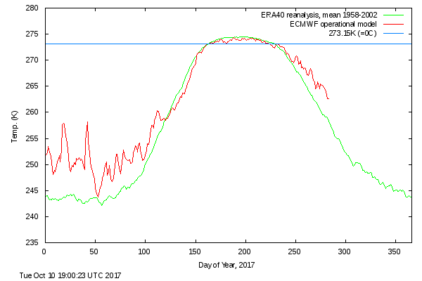
In this case, the concern is ice freezing and snowpack. The warmer temps could also be correlated with warmer SSTs, though which drives which (if not both) is a question I am not qualified to answer. In any case, we did see last year how extreme warmth slowed down and at times reversed the sea ice extent trajectory, so I am hesitant to say that the temperatures don't matter.
-
Arctic ocean temps remain fairly well above normal, though not quite as bad as last year. I suspect we'll see a slowdown in the refreeze. Not calling for catastrophe, but certainly unlikely to be a big rebound. vs
-
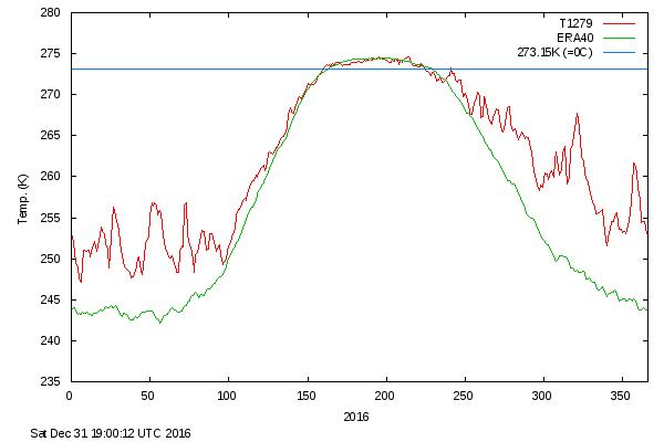
Yeah, what the hell is going on? We're having a more summerlike pattern now in mid-late September than we did in mid-late August, and temperatures are almost as warm for it. I've never seen such a large area of anomalously high heights across the midlatitudes and polar regions. It looks like the 2015-2017 pattern is continuing, and at this rate, we might get another warmest year out of 2017, which I was not expecting a few months ago.
-
To be fair, the median ice extent (15% concentration) this time of year is quite a ways away from Barrow. You have to go back to the early parts of the 20th century before you'd generally see ice in Barrow at this time of year.

