PaulyFromPlattsburgh
-
Posts
532 -
Joined
-
Last visited
Content Type
Profiles
Blogs
Forums
American Weather
Media Demo
Store
Gallery
Everything posted by PaulyFromPlattsburgh
-
at 168 no phase. energy way offshore. onto the next run. this run took it into bermuda
-
no closed 500mb southern stream low. at 164 it already scoots offshore with no NS phase. looks like a miss
-
unlike 12z yesterday. that southern stream just scoots east and does not energize and slow down for NS but instead drags the baroclinic zone east with it
-
strong southern and northern stream vorticities just lack of coupling at least through 156 on pivotal. southern stream way ahead of NS
-
looks like euro is coming in a close miss. again
-
Yeh blizzard into Louisiana. Nuts
-
ICON was classic benchmark. CMC coastal hugger, GFS just SE benchmark. You are right tho, all pretty similar. pretty good agreement at the development of a potent coastal storm this far out. Encouraging!
-
Upstate/Eastern New York
PaulyFromPlattsburgh replied to BuffaloWeather's topic in Upstate New York/Pennsylvania
good thing is lakes are open for buisness for you guys still. lets hope something can trigger them to lightup. wish P burgh benefited from the lakes haha. very rare -
Yes a surface high would be great. yeh verbatim surface temps are between 33-35 but with such a dynamic strong storm im sure thats isothermal snow for many even down to the coast that run!
-
Upstate/Eastern New York
PaulyFromPlattsburgh replied to BuffaloWeather's topic in Upstate New York/Pennsylvania
I wouldn’t worry about the long range ICON. GEFS and EPS still look pretty good. We will see. Small window of opportunity for this to phase perfectly with indicies transiently favorable -
Upstate/Eastern New York
PaulyFromPlattsburgh replied to BuffaloWeather's topic in Upstate New York/Pennsylvania
still coming down nice. radar filled in well with temps crashing just in time to cash in just a bit. in this putrid leftover stale airmass. -
Upstate/Eastern New York
PaulyFromPlattsburgh replied to BuffaloWeather's topic in Upstate New York/Pennsylvania
radar filling in nice. mhm. no models had me getting any accum. snow. but all day it looked like many areas were colder than forecasted. hopefully it wont switch back to rain. NWS had champlain valley as all rain also with no snow indications. -
Upstate/Eastern New York
PaulyFromPlattsburgh replied to BuffaloWeather's topic in Upstate New York/Pennsylvania
it is absolutely ripping outside. heavy snow. biggest flakes i ever seen. so wet. sticking to everything. highlight of my day . might get a quick inch with some moisture leftover -
Upstate/Eastern New York
PaulyFromPlattsburgh replied to BuffaloWeather's topic in Upstate New York/Pennsylvania
switched to all snow. 32 big flakes. im in the valley also low elevation. nice surprise -
Upstate/Eastern New York
PaulyFromPlattsburgh replied to BuffaloWeather's topic in Upstate New York/Pennsylvania
33 degrees with a mix of rain and snow. -
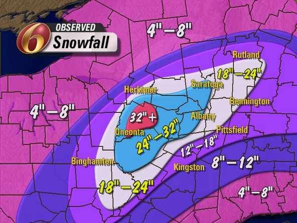
boxing day 2010 http://cstar.cestm.albany.edu/PostMortems/CSTARPostMortems/2010/dec26_27blizzard/dec2010blizzard.htm
-
why are we even looking at precip type verbatim atm? the signal is there for a significant storm. something we have not had to even track in a long time
-
you are 100% right . looking at 168 it looks like it is just about to become a cutoff but by 196 that NS dives in quickly and perfectly to phase with it. I doubt we will replicate this solution verbatim again next run
-
you forgot the ketchup!!
-
198 we have a 971mb south of long island. big bomb. could tell from the early stages. happy tracking !! EVERYONE except extreme COASTAL areas absolutely hammered this run. It was so amped. so dynamic. many cash in as temps will crash
-
yes classic on this run
-
yes this looks very wound up. maybe even to much so this run. great sign at this point out as mentioned
-
987 into deleware at 192! wow. coastal hugger? we shall see
-
996mb low on cape hatt at 186
-
by the looks of H5. THIS is gonna be a bomb
