PaulyFromPlattsburgh
-
Posts
532 -
Joined
-
Last visited
Content Type
Profiles
Blogs
Forums
American Weather
Media Demo
Store
Gallery
Everything posted by PaulyFromPlattsburgh
-
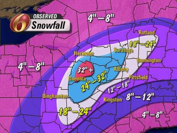
I am highly concerned that many local weather stations are undermining icing threat. mesoscales really starting to point to a confined but solid area of significant icing
-
Upstate/Eastern New York
PaulyFromPlattsburgh replied to BuffaloWeather's topic in Upstate New York/Pennsylvania
looks like they are expecting at least a moderate chance of some good lake effect in scattered spots. not a widespread event but something nonetheless -
Upstate/Eastern New York
PaulyFromPlattsburgh replied to BuffaloWeather's topic in Upstate New York/Pennsylvania
comparing hour 39 of 0z at 700mv temps vs hour 45 on 18z you can see the freezing line is easily now 20 miles south and west of 18z same time frame. poor poor snow growth but wet snow at that eventually changing to sleet. -
Upstate/Eastern New York
PaulyFromPlattsburgh replied to BuffaloWeather's topic in Upstate New York/Pennsylvania
undeniably md/hvy snow hours 27/28 so far on the nam. better initial waa so far. cant post image but evident on 12k nam and below freezing all layers at those frames. edit: tad colder than 18z and nice burst of snow from the initial stuff. 700mb 0c line is pushed 10 miles southwest of 18z. precip is also shunted a bit more prob cause of the high pressing down more this run. Edit #2 Still snowing at hour 39. This 10-15 mile south push by the freezing line has kept me all snow so far this run. 10-20 miles to my south and west its sleeting and raining. Sharper precip cutoff gradient to the north and east this run also. 700mg stays between -1 to -2 consistently though 39. EDIT #3. at hr 45 we finally switch to some moderate sleet after some good initial snow, about 4-6 inches of heavy wet snow initially on the NAM taken into account 8:1 ratios. -
Upstate/Eastern New York
PaulyFromPlattsburgh replied to BuffaloWeather's topic in Upstate New York/Pennsylvania
Watch for my area. they seem to be hinting at more ice than i see.(WINTER STORM WATCH IN EFFECT FROM SUNDAY EVENING THROUGH TUESDAY EVENING... * WHAT...HEAVY MIXED PRECIPITATION POSSIBLE. TOTAL SNOW AND SLEET ACCUMULATIONS OF UP TO 6 INCHES, ESPECIALLY FOR CENTRAL AND EASTERN VERMONT. MEANWHILE, ICE ACCUMULATIONS OF 0.25 TO 0.50 INCH IS POSSIBLE FOR THE SAINT LAWRENCE VALLEY, PARTS OF THE ADIRONDACKS AND SOUTHERN SECTIONS OF THE CHAMPLAIN VALLEY. * WHERE...NORTHERN NEW YORK AND MOST OF CENTRAL, EASTERN, AND SOUTHERN VERMONT, INCLUDING PORTIONS OF THE CHAMPLAIN VALLEY. * WHEN...FROM SUNDAY EVENING THROUGH TUESDAY EVENING. * IMPACTS...ISOLATED TO SCATTERED POWER OUTAGES AND TREE DAMAGE IS POSSIBLE, ESPECIALLY WHERE ICE ACCUMULATION APPROACHES 0.50 INCH. THE HAZARDOUS CONDITIONS WILL IMPACT THE MORNING AND EVENING COMMUTES ON MONDAY AND TUESDAY. * ADDITIONAL DETAILS....PLEASE NOTE PORTIONS OF THIS WATCH WILL LIKELY BE CONVERTED TO A WINTER WEATHER ADVISORY, WHILE HIGHEST POTENTIAL FOR WARNING CRITERIA BEING REACH IS ACROSS THE NORTHERN ADIRONDACKS INTO CENTRAL AND SOUTHERN VERMONT. PRECAUTIONARY/PREPAREDNESS ACTIONS... MONITOR THE LATEST FORECASTS FOR UPDATES ON THIS SITUATION. &&) -
Upstate/Eastern New York
PaulyFromPlattsburgh replied to BuffaloWeather's topic in Upstate New York/Pennsylvania
Thank you. I appreciate the feedback -
Upstate/Eastern New York
PaulyFromPlattsburgh replied to BuffaloWeather's topic in Upstate New York/Pennsylvania
I will do ObS and let everyone know what I end up getting. Thank you all for being honest. Hoping for a few ticks colder in the next few runs and in the mesos -
Upstate/Eastern New York
PaulyFromPlattsburgh replied to BuffaloWeather's topic in Upstate New York/Pennsylvania
I understand. I definitely won’t get rain which is a good thing. It’s either snow or ice and sleet at this point with exact details still to be pinpointed. Thanks for the brutal honesty. I probably shouldn’t get my hopes up to much -
Upstate/Eastern New York
PaulyFromPlattsburgh replied to BuffaloWeather's topic in Upstate New York/Pennsylvania
Verbatim even on pivotal I get 8 inches. Just glad we have the chance for frozen regardless of snow ice or sleet. Deff not rain, that’s 100% certain with the surface never going above 30! -
Upstate/Eastern New York
PaulyFromPlattsburgh replied to BuffaloWeather's topic in Upstate New York/Pennsylvania
Lol u are wrong man. The intial surge is where I money on this run. Only hour I sleet is around 45, the one u posted. Read my posts above. I am expecting 4-7 inches of snow/sleet with a with a possibility of around .10-.25 inches of ice. -
Upstate/Eastern New York
PaulyFromPlattsburgh replied to BuffaloWeather's topic in Upstate New York/Pennsylvania
I don’t think you know where I am located. I don’t sleet except for a few hours on the backend of the first surge. I checked the sounding and everything and can tell you that the 18z NAM is 90% snow for my area. In Plattsburgh northern adirondacks. Btw u posted the warmest frame there is hr45. That is the only few hours I sleet. I am below freezing entirely at all levels afterwards. Quick crash in temps from back door cold front. -
Upstate/Eastern New York
PaulyFromPlattsburgh replied to BuffaloWeather's topic in Upstate New York/Pennsylvania
NAMMED! -
Upstate/Eastern New York
PaulyFromPlattsburgh replied to BuffaloWeather's topic in Upstate New York/Pennsylvania
18z too vs 12z bottom. -
Upstate/Eastern New York
PaulyFromPlattsburgh replied to BuffaloWeather's topic in Upstate New York/Pennsylvania
NAM is a big hit for my area. Drastically reduced sleet potential and increased snow. Starting to track this hard. WSW issued for the area up to .5 inches ice accumalation with up to 6 inches of snow! -
Upstate/Eastern New York
PaulyFromPlattsburgh replied to BuffaloWeather's topic in Upstate New York/Pennsylvania
Euro is really cold. I’m currently expecting 4-7 inches of snow with some freezing rain. Initial call -
NAM verbatim is a lot of frozen snow/ice/sleet for a lot of the area. Obviously the map is not all snow but clearly shows the potential for precip other than rain
-
Upstate/Eastern New York
PaulyFromPlattsburgh replied to BuffaloWeather's topic in Upstate New York/Pennsylvania
NAM is a huge hit for my area. Cold too we stay as snow. Lot of that other crap further south is sleet -
NAM is hella warm . Mix all the way to Canadian border
-
Upstate/Eastern New York
PaulyFromPlattsburgh replied to BuffaloWeather's topic in Upstate New York/Pennsylvania
once again pivotal doesnt include sleet in its formula. the 10:1 i agree is a bit high maybe 8:1. -
Upstate/Eastern New York
PaulyFromPlattsburgh replied to BuffaloWeather's topic in Upstate New York/Pennsylvania
I am in extreme north/ northeastern NY by Montreal Canada border right across from Burlington on a ferry. In fact for my area both models I mentioned show some long duration snows -
Upstate/Eastern New York
PaulyFromPlattsburgh replied to BuffaloWeather's topic in Upstate New York/Pennsylvania
Euro is a monster hit for my area between both rounds!!! Similar to CMC. -
CMC is a big hit for many. Inland especially. Delivers the goods to a majority of Vermont New Hampshire some of Maine and even extreme northeaster NY where I am located, by Montreal border
-
Upstate/Eastern New York
PaulyFromPlattsburgh replied to BuffaloWeather's topic in Upstate New York/Pennsylvania
It is also colder for the synoptic delivering the goods. 16 inches plus of heavy wet snow verbatim on the CMC from both synoptic storms combined... seems like extreme north north east New York and Vermont New Hampshire and Maine have a chance at some big snows with this one. -
Upstate/Eastern New York
PaulyFromPlattsburgh replied to BuffaloWeather's topic in Upstate New York/Pennsylvania
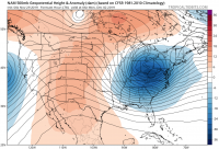
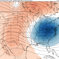
+5 wow. Big storms happen around sudden and drastic (+5-8 variation in 10 day period)pattern shifts like this notorious for something to pop -
Upstate/Eastern New York
PaulyFromPlattsburgh replied to BuffaloWeather's topic in Upstate New York/Pennsylvania
I will take this run. Maybe being so far north and east will help me this time. We will see. In the purple for now.


