
Imneversatisfied
-
Posts
69 -
Joined
-
Last visited
Content Type
Profiles
Blogs
Forums
American Weather
Media Demo
Store
Gallery
Everything posted by Imneversatisfied
-
Pre-Christmas (Dec 21-23rd) Winter Storm Part 2
Imneversatisfied replied to Chicago Storm's topic in Lakes/Ohio Valley
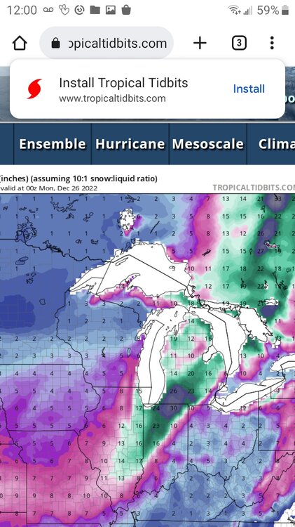
Well I was giddy as a school girl at 11pm when the rain changed to snow here in Alpena. I was thinking it was going to rain all night. Woke up to about 2-4in of concrete snow. It's still lightly snowing and the wind is really ramping up. Hoping to atleast get a few more inches thru Sunday and some drifting. Atleast I'll have a white Christmas even if it's not a historic blizzard. -
Pre-Christmas (Dec 21-23rd) Winter Storm Part 2
Imneversatisfied replied to Chicago Storm's topic in Lakes/Ohio Valley
Man I was only 3 yrs old. I do remember snowier winters in the late 80s to 90s as a kid here tho. Btw it's now finally puking flakes and it's time for bed. Hoping to wake up to atleast a few inches ( that's what she said) -
Pre-Christmas (Dec 21-23rd) Winter Storm Part 2
Imneversatisfied replied to Chicago Storm's topic in Lakes/Ohio Valley
Forecast via APX now saying Alpena,Michigan remains rain until 9am Fri. Looks like heaviest precipitation will be thru by time it changes over to snow and then 4" total. I sure hope they are wrong. But they tend to know their stuff. I'm pretty disappointed as many others now. -
Pre-Christmas (Dec 21-23rd) Winter Storm Part 2
Imneversatisfied replied to Chicago Storm's topic in Lakes/Ohio Valley
Rain here for the past hour in Alpena. 15 miles away inland theres already 2". -
Pre-Christmas (Dec 21-23rd) Winter Storm Part 2
Imneversatisfied replied to Chicago Storm's topic in Lakes/Ohio Valley
Lucky lol Its rain in alpena right now. I'm in the city about a mile or two inland from Lake Huron.Hopefully it changes over quick here. I love snow! Lol Regardless I'll be happy to have a white Christmas after how the past ones have been... -
Pre-Christmas (Dec 21-23rd) Winter Storm Part 2
Imneversatisfied replied to Chicago Storm's topic in Lakes/Ohio Valley
Thanks again. I was thinking the low center would be further east initially watching the ecmwf,cmc,gfs the past few days. Now NAM and a few others show the low centered as u mentioned.Being that close to the low and Lake Huron will bring warmer air in for a period of time cutting into snow total right? Or could it make it produce more eventually being that close to the deepening low? Definitely an interesting setup taking shape. Just hope it's not a bust here after an initial 8-12" forecasted up until 3 hrs ago by NWS. -
Pre-Christmas (Dec 21-23rd) Winter Storm Part 2
Imneversatisfied replied to Chicago Storm's topic in Lakes/Ohio Valley
Wow thanks so much for the breakdown on what might happen. Btw which models are you looking at? I'm definitely hoping all snow lol I'll have updates as things unfold. Unfortunately the main show might be just northwest of me. -
Pre-Christmas (Dec 21-23rd) Winter Storm Part 2
Imneversatisfied replied to Chicago Storm's topic in Lakes/Ohio Valley
APX are the only place predicting Alpena stays too warm overnight and gets rain. It would cut into some of the best precip rates too. I only see two models showing that too. Hopefully they get that part wrong. Atleast for my sake lol -
Pre-Christmas (Dec 21-23rd) Winter Storm Part 2
Imneversatisfied replied to Chicago Storm's topic in Lakes/Ohio Valley
Here it is! I cant remember the last time we were under one...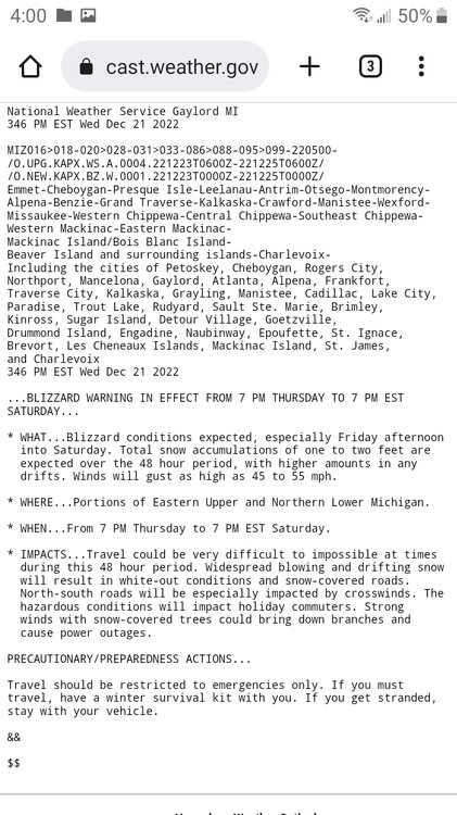
-
Pre-Christmas (Dec 21-23rd) Winter Storm Part 2
Imneversatisfied replied to Chicago Storm's topic in Lakes/Ohio Valley
Bring it on! Ready to buried! -
Pre-Christmas (Dec 21-23rd) Winter Storm Part 2
Imneversatisfied replied to Chicago Storm's topic in Lakes/Ohio Valley
Awesome post! I appreciate the info. My parents have a picture of them on a drift level with a two story window for 78'. I definitely dont expect that but should be a fun storm here in Alpena. -
Pre-Christmas (Dec 21-23rd) Winter Storm
Imneversatisfied replied to Chicago Storm's topic in Lakes/Ohio Valley
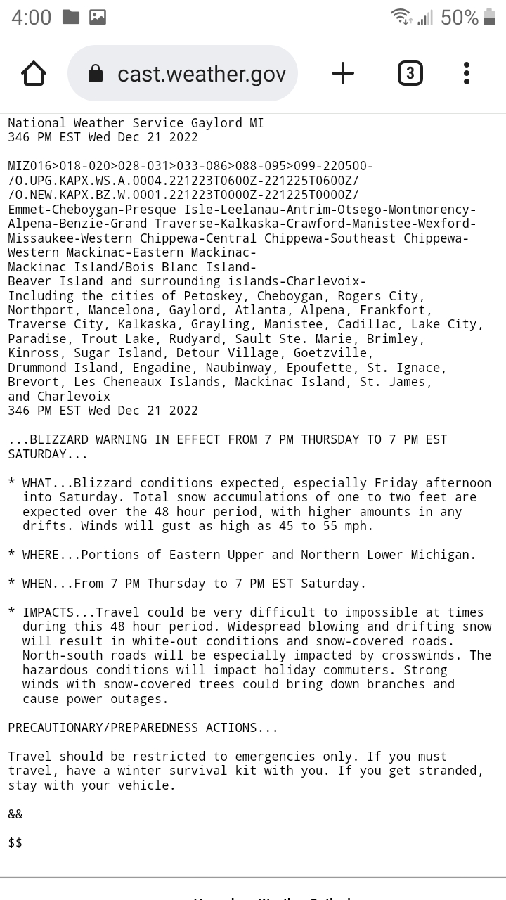
NWS just issued a Winter Storm Watch for my area. Bring it on! ...WINTER STORM WATCH IN EFFECT FROM EARLY FRIDAY MORNING THROUGH LATE SATURDAY NIGHT... * WHAT...Blizzard conditions possible. Total snow accumulations of a foot or more may be possible by Sunday morning. Winds could gust as high as 45 to 55 mph. * WHERE...Portions of Eastern Upper and Northern Lower Michigan. * WHEN...From late Thursday night through late Saturday night. * IMPACTS...Significant blowing and drifting snow will create dangerous travel...with snow covered roads and drastically reduced visibility to white-out conditions. North-south roads will be especially impacted by crosswinds. The hazardous conditions could impact all holiday commuters. Strong winds with snow-covered trees could bring down tree branches and cause power outages. -
Pre-Christmas (Dec 21-23rd) Winter Storm
Imneversatisfied replied to Chicago Storm's topic in Lakes/Ohio Valley
Cool too see someone from my area on here! My actual name is Travis too! Lol -
Pre-Christmas (Dec 21-23rd) Winter Storm
Imneversatisfied replied to Chicago Storm's topic in Lakes/Ohio Valley
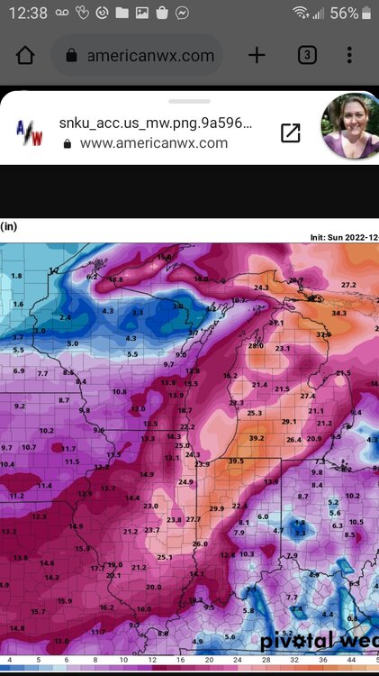
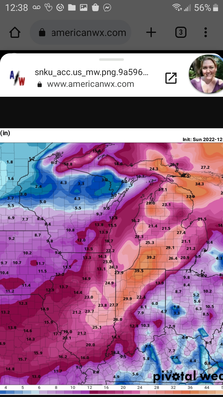
With the way this storm has moved around over the past 7 days and gave hopes and dreams of a blizzard from the east coast people to now Chicago,should name it winter storm Grinch or Soulcrusher. Lol I still believe there will be blizzard conditions for most of the great lakes area just due to the intense winds and any amount of snow that does fall. As for my location in Alpena,Michigan it still looks like atleast 8in and 40+mph winds. I'll take it. -
Pre-Christmas (Dec 21-23rd) Winter Storm
Imneversatisfied replied to Chicago Storm's topic in Lakes/Ohio Valley
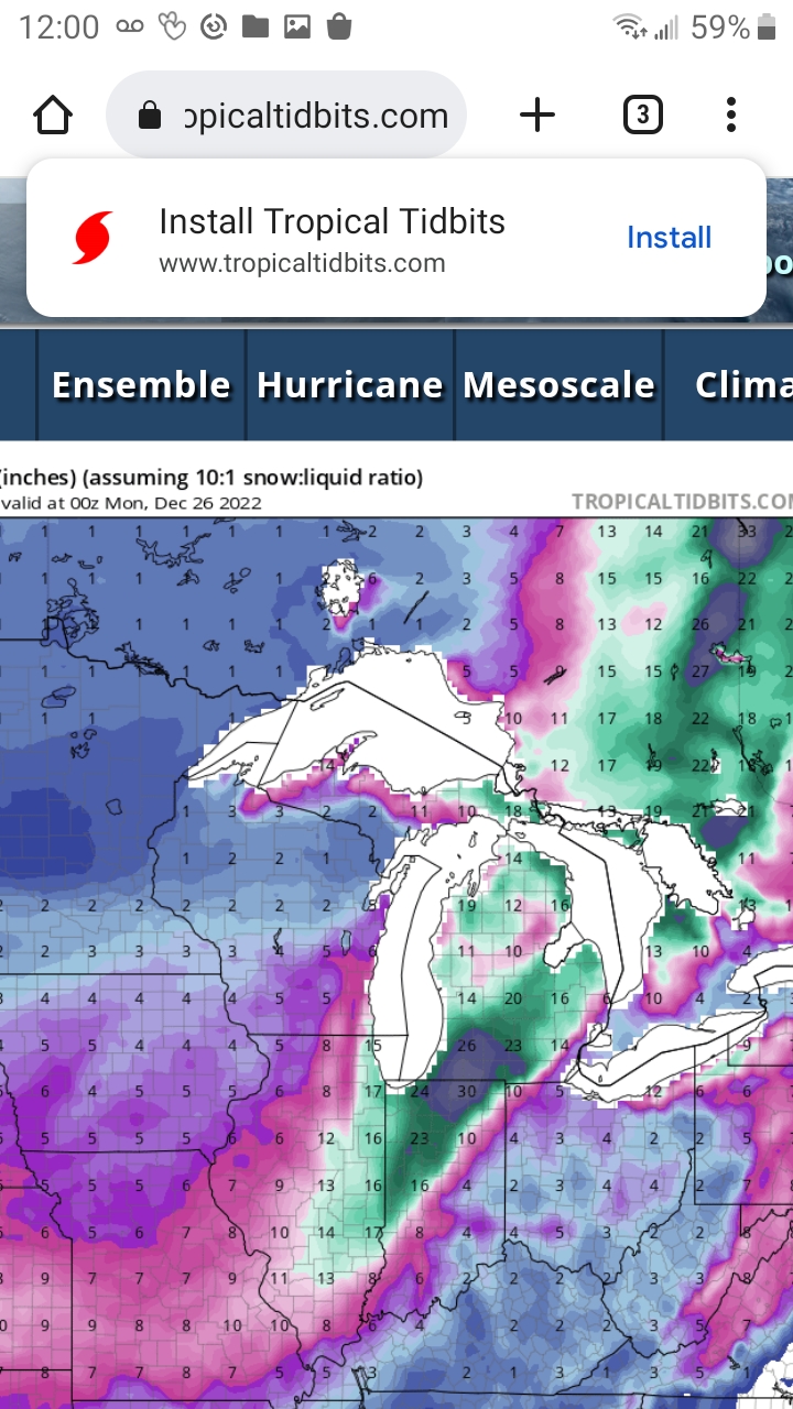
Thanks for the maps Omega. Def helps visualize the possibilities. Going to start prepping to hunker down for a few days just in case. Just happy to have a white Christmas really. -
Pre-Christmas (Dec 21-23rd) Winter Storm
Imneversatisfied replied to Chicago Storm's topic in Lakes/Ohio Valley
What are the odds the slp locations move east due to such a strong arctic front push? -
Pre-Christmas (Dec 21-23rd) Winter Storm
Imneversatisfied replied to Chicago Storm's topic in Lakes/Ohio Valley
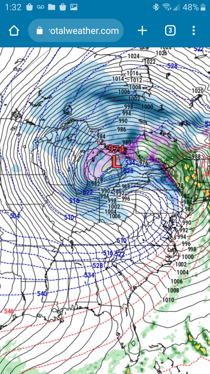
12z Euro is almost a 974 low party off Alpena,MI. Really hope it wraps in the cold fast enough for all snow and maybe nudge SE in SLP location,then I'd be buried! I'll take my 6"and be happy (that's what she said!)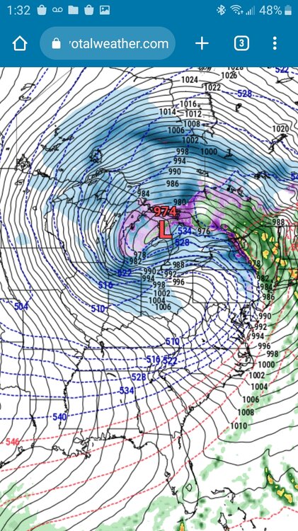
-
Pre-Christmas (Dec 21-23rd) Winter Storm
Imneversatisfied replied to Chicago Storm's topic in Lakes/Ohio Valley
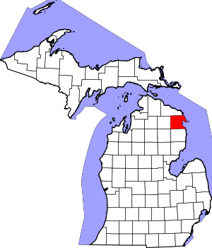
Well this potential storm has finally made me come out of hiding. I've been lurking for over 10 years including the old forums! Every winter I come to read the analysis from everyone,to see the maps and better my weather knowledge.The banter is great entertainment as well! I live in Alpena,MI which is near the mitten's index finger right on Lake Huron. In the future I will try to post often with reports in my area. Over the past 15 years of weather watching for my area, I dont recall a sub 975mb low taking this projected path and potentially burying me in an epic Christmas blizzard that I have always dreamed of.I'm expecting 12"+ and 40+mph winds. Some "clown maps" even show 37.9in??? Lol Either way I'm a 36 year old feeling like a kid again. Just wish I had a snowmobile...