
Imneversatisfied
-
Posts
69 -
Joined
-
Last visited
Content Type
Profiles
Blogs
Forums
American Weather
Media Demo
Store
Gallery
Everything posted by Imneversatisfied
-
1/8-1/10 Potential Winter Storm
Imneversatisfied replied to Thundersnow12's topic in Lakes/Ohio Valley
Woke up very surprised to about 6" of snow with 1' drifts! Just finished snowblowing 3 driveways. Looks like a legit blizzard here Friday and Saturday then the Arctic blast comes. Perfect! I feel like a kid again at 37. Lol -
1/8-1/10 Potential Winter Storm
Imneversatisfied replied to Thundersnow12's topic in Lakes/Ohio Valley
Getting the ole dry slot right now with mix. Ground is finally covered. Atlanta,MI is about 30 miles away inland and has 4" otg. Hopefully once it passes and heaviest returns move over,can stack some flakes thru the night. -
1/8-1/10 Potential Winter Storm
Imneversatisfied replied to Thundersnow12's topic in Lakes/Ohio Valley
Bright returns on radar have begun to move into the Alpena area. All snow so far. Just beginning to accumulate on grass. 18z GFS has the low even farther SE. Me likey! Hope it's the last time I see grass for a few months. -
1/8-1/10 Potential Winter Storm
Imneversatisfied replied to Thundersnow12's topic in Lakes/Ohio Valley
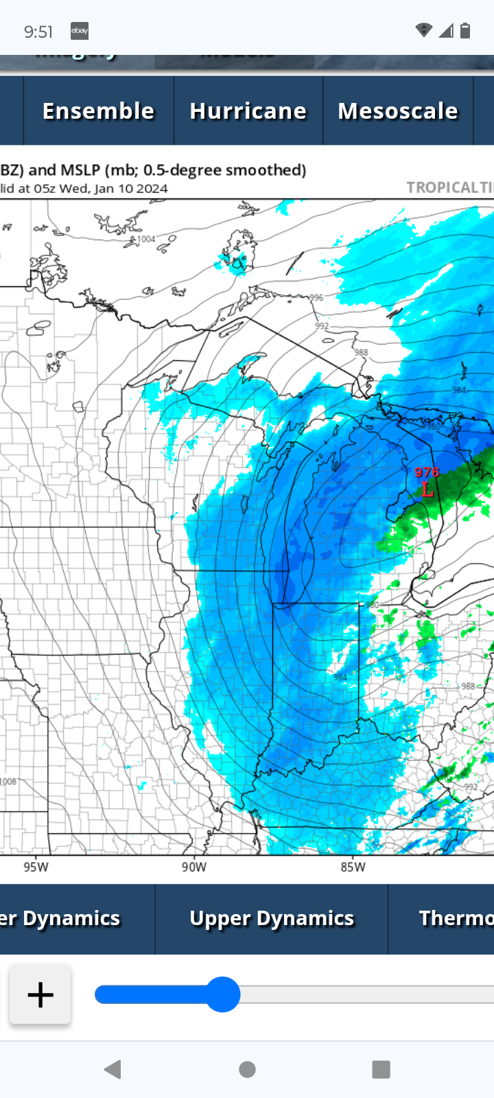
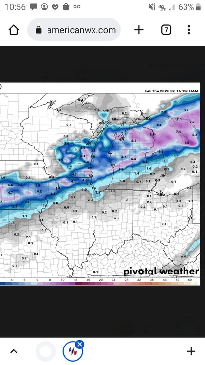
12z NAM has a nice defo band and 976mb low just SE. Hoping to nowcast blizzard conditions this tonight lol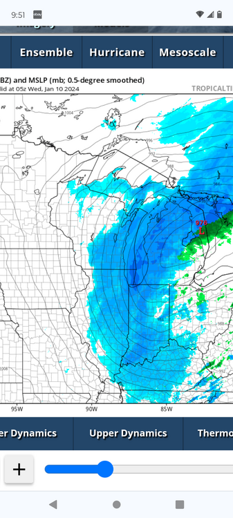
-
1/8-1/10 Potential Winter Storm
Imneversatisfied replied to Thundersnow12's topic in Lakes/Ohio Valley
I might be wish casting but looks to me 12z runs are trending slp SE. Anyone confirm? -
1/8-1/10 Potential Winter Storm
Imneversatisfied replied to Thundersnow12's topic in Lakes/Ohio Valley
Snow shower just started in Alpena! Was expecting rain. Hopefully it stays flakes. -
1/8-1/10 Potential Winter Storm
Imneversatisfied replied to Thundersnow12's topic in Lakes/Ohio Valley
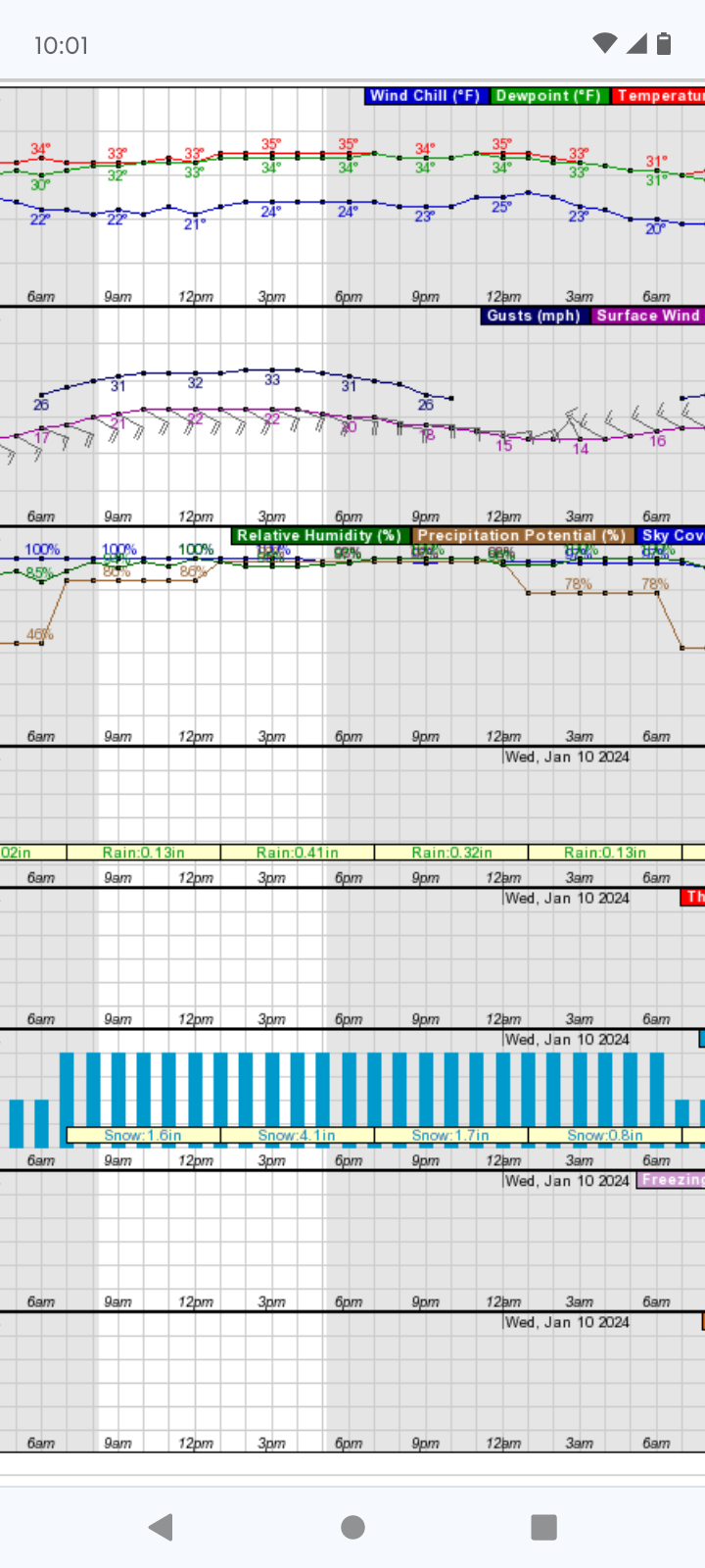
Temp is at 35 with 20 mph E wind in Alpena this morning. Even with the SE trend still not feeling good about rain/mix forecast of only 1-2" by APX. I don't know what to think really. Back to nowcasting. Lol My final call is 3" by Wed afternoon. Starts this morning around noon. Most models are showing all snow until the low is just offshore tonight then a chance of mixing. Fingers crossed the warm tongue stays short.
-
1/8-1/10 Potential Winter Storm
Imneversatisfied replied to Thundersnow12's topic in Lakes/Ohio Valley
We are at roughly 12" average is 28". Looks like the next storm might tundra me. Lost faith in this one. Lol -
1/8-1/10 Potential Winter Storm
Imneversatisfied replied to Thundersnow12's topic in Lakes/Ohio Valley
Pretty disappointing for me in Alpena too. Really need a SE shift. Starting to focus my attention on the weekend storm. -
1/8-1/10 Potential Winter Storm
Imneversatisfied replied to Thundersnow12's topic in Lakes/Ohio Valley
I need like a 50 mile SE shift. Damn warm lake is going to screw me if not. -
1/8-1/10 Potential Winter Storm
Imneversatisfied replied to Thundersnow12's topic in Lakes/Ohio Valley
APX went from forecasting 6" at noon now less than an inch in Alpena. Sounds like they plan on the warm air aloft will create mixing. Only model I see having rain reach here is FV3 all others are snow. Hmmm Sure hope they are wrong... Let the disappointment begin. -
1/8-1/10 Potential Winter Storm
Imneversatisfied replied to Thundersnow12's topic in Lakes/Ohio Valley
Im contemplating firing mine up altho it last ran two months ago not years lol so I'm not too worried. Plus I work on small engines and love snow so my blowers (yes I have 2) are àll tuned up and ready. Just don't wanna jinx anything now! Btw if you couldn't get it started,try taking the spark plug out,clean the end with wire brush and spray starting fluid,carb,cleaner,or a put a few drops of gas in the plug hole,put plug back in and it should fire and prime the fuel system. Good luck. Shoveling sucks. -
1/8-1/10 Potential Winter Storm
Imneversatisfied replied to Thundersnow12's topic in Lakes/Ohio Valley
Music to my ears -
1/8-1/10 Potential Winter Storm
Imneversatisfied replied to Thundersnow12's topic in Lakes/Ohio Valley
Looks like I'm in for around 6" of snowman making snow and some good winds! Temps still have me a lil scared
-
1/8-1/10 Potential Winter Storm
Imneversatisfied replied to Thundersnow12's topic in Lakes/Ohio Valley
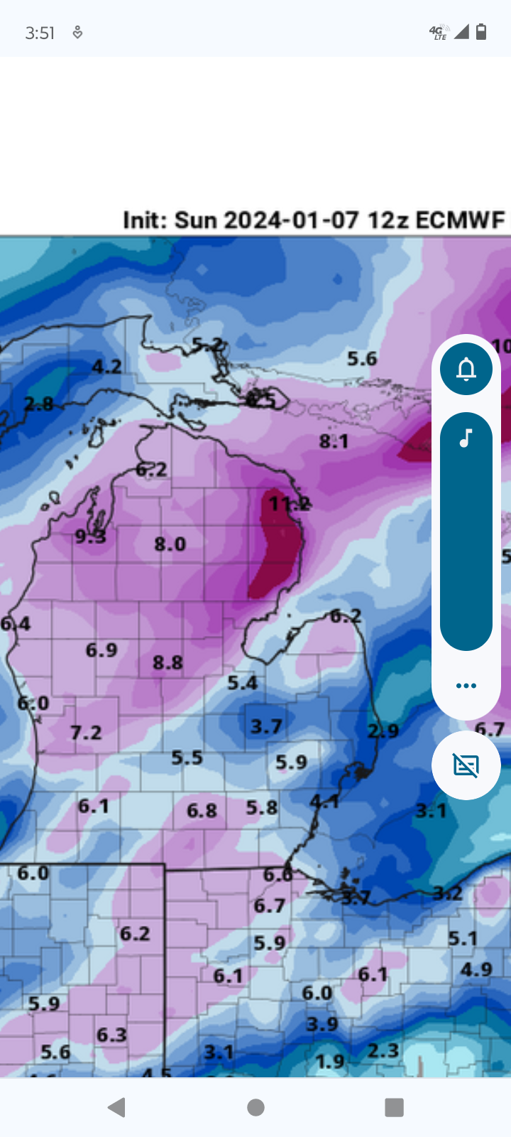
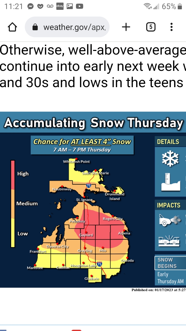
Woke up to the pleasant surprise of a Winter Storm Watch being issued and NWS Gaylord making this man child very happy. Lol Just hope it verifies with no NW shift! After a few days of waffling back and forth, model consensus has mostly coalesced on a track across north central lower. This would likely bring the surface low across the Thumb region which is usually very favorable for heavy snowfall across much of northern lower and eastern upper Michigan given the expected ample moisture being transported up from the south as well as sufficiently cold air. A few outlying solutions do track the surface low farther northwest across northern lower which would cut into snowfall amounts and introduce precipitation type issues but have discounted these solutions for now. So snow is expected to develop early Tuesday morning and become heavy at times Tuesday afternoon and evening before diminishing early Wednesday. Looking at thermal profiles the consistency of the snow is expected to be heavy/wet which will likely exasperate travel difficulties as well as possibly lead to isolated power outages (especially given gusty northeast winds). Wrap around/lake effect snow behind the system is then expected Wednesday. Inland total snow accumulations are expected to be in the 6 to 10 inch range with some spots possibly seeing close to a foot. Lakeshore areas near Saginaw Bay will likely see lesser amounts in the 4 to 8 inch range due to a possible mix with rain and lower qpf amounts. Winter storm watches will be issued. -
1/8-1/10 Potential Winter Storm
Imneversatisfied replied to Thundersnow12's topic in Lakes/Ohio Valley
That would help a lot as the easterly wind might enhance snowfall vs making it rain if it was warm aloft. Being right next to the Lake Huron shore can have huge impacts on weather, sometimes like a micro climate mechanism. -
1/8-1/10 Potential Winter Storm
Imneversatisfied replied to Thundersnow12's topic in Lakes/Ohio Valley
Thanks for posting the NBM. Didn't know about it before and wish I hadn't now lol I have noticed the shift SE again tho on 18z runs. Sure is nice to track something either way! -
1/8-1/10 Potential Winter Storm
Imneversatisfied replied to Thundersnow12's topic in Lakes/Ohio Valley
NWS is only giving Alpena a 20% chance of 4" + and interior northern mi 80%. Stating closer to Lake Huron the greater chance of rain mix. Not sure if they are using NAM as usual to base forecast as ECMWF and GFS both moved the slp more south today. Time to thread the needle! -
1/8-1/10 Potential Winter Storm
Imneversatisfied replied to Thundersnow12's topic in Lakes/Ohio Valley
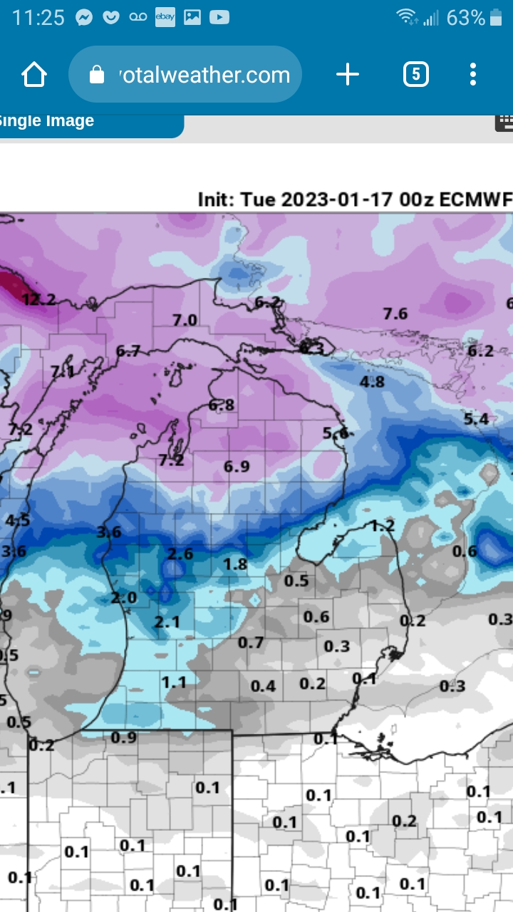
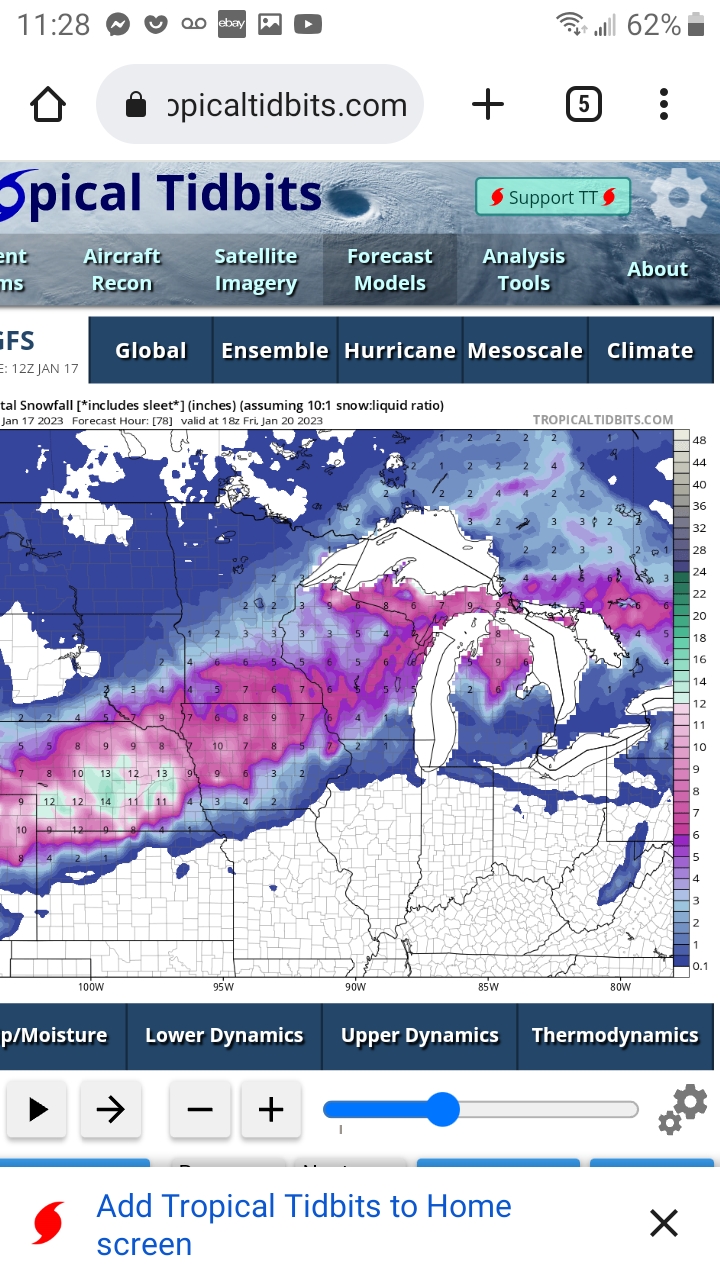
Lastest ECMWF SE shift puts me back into the best snows. Still worried about wind off the lake creating p type issues. Let's see if the next GFS run follows suit. As for slp, pretty remarkable how consistent models have been for a sub 980mb low in the great lakes region for over a week. Now the show really begins.
-
1/8-1/10 Potential Winter Storm
Imneversatisfied replied to Thundersnow12's topic in Lakes/Ohio Valley
After lurking around and watching models for a week thinking I was in a good location here in Alpena, it looks like the rug is being pulled NW. Interesting to see how almost every model has shifted NW in the last day. What happened? Is the NAM reeling this into it's realm or will the models shift back SE? Just a few hundred mile shift has me go from 4" to 16". The low is now forecast to be right offshore of Alpena as a 975ish mb low which leads to precipitation type issues with the E wind over warm Lake Huron. Seen it too many times over the years,unless air temp is under 30 which then develops lake enhanced snow. This one's going to be a nail biter! After December I will take whatever I can get! Just happy to track some storms and read the posts on here taking note of everyone's analysis. Hoping to reel this back SE though! -
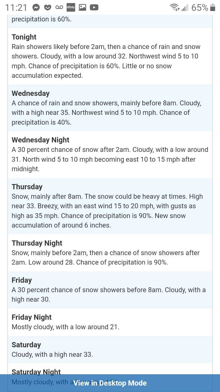
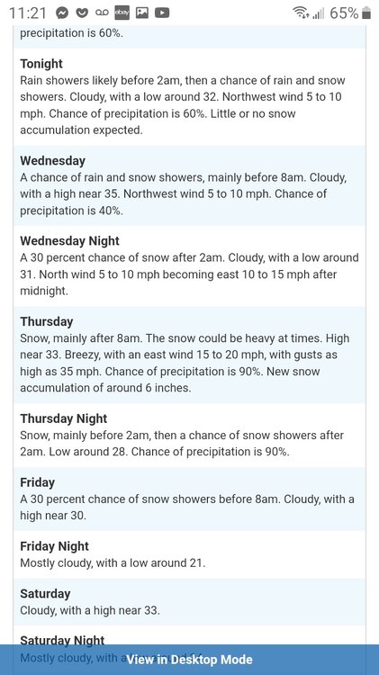
NWS issued a winter storm warning for me this evening here in Alpena, starting at 1pm Wednesday thru 7pm Thursday. Forecasted to get 7" to 12" with 30mph winds off Lake Huron which should enhance snowfall. I'm ready to be buried!!!
-
Woke up pleasantly surprised with 7" of fluff. Spent the morning snowblowing then played around on the atv. Looks like I'm going to do it all over again this time next week. Cant wait!
-
Latest NAM is jackpot here in Alpena,mi. I'll believe it when I see it lol
-
Jan 19-20: Hoosier is not allowed to start this thread
Imneversatisfied replied to mimillman's topic in Lakes/Ohio Valley
I've been reluctant to post in this thread hoping not to jinx this storm away from me. Lol Looking like a solid 6" storm with 30 mph winds off Lake Huron which could create some rare lake enhancement here in Alpena. It will also be a rare daytime,heavy accumulation snow event. Hopefully it doesnt get too warm and we get rain or the storm shifts NW and get nothin...

-
Pre-Christmas (Dec 21-23rd) Winter Storm Part 2
Imneversatisfied replied to Chicago Storm's topic in Lakes/Ohio Valley
The sun is peaking thru the clouds here in alpena,mi during peak angle and wind is really starting to ramp up with gusts to 30 mph. Very light flurries falling. I'm only expecting up to an inch for the rest of the storm with lots of blowing and drifting.