
Imneversatisfied
-
Posts
69 -
Joined
-
Last visited
Content Type
Profiles
Blogs
Forums
American Weather
Media Demo
Store
Gallery
Everything posted by Imneversatisfied
-
Thanks! Not looking good...
-
It's looking like a high impact freezing rain event for northern Michigan this weekend. Both GFS and CMC have freezing rain falling for over 24 hrs! Does anyone have freezing rain accumulation maps? I can't seem to find any.
-
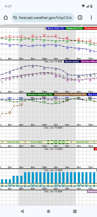
Under a warning for 6-8" in Alpena. Supposed to start around 1 pm and snow till 7 am Thursday. I can't wait to wake up tomorrow morning if I can sleep at all lol

-
I'm surprised to still be in the game after all the model changes. My call of 6" still looks good for Alpena. Knock on wood.
-
I'm still looking good in Alpena. Hoping for some rare lake enhancement off Huron to help accumulation. Going with a 6" total by noon Thursday. Only 48 hrs to go! Now I'm jinxed lol
-
2/14-2/15 Potential Major Winter Storm
Imneversatisfied replied to A-L-E-K's topic in Lakes/Ohio Valley
I've been addicted to model porn since I was 12 lol -
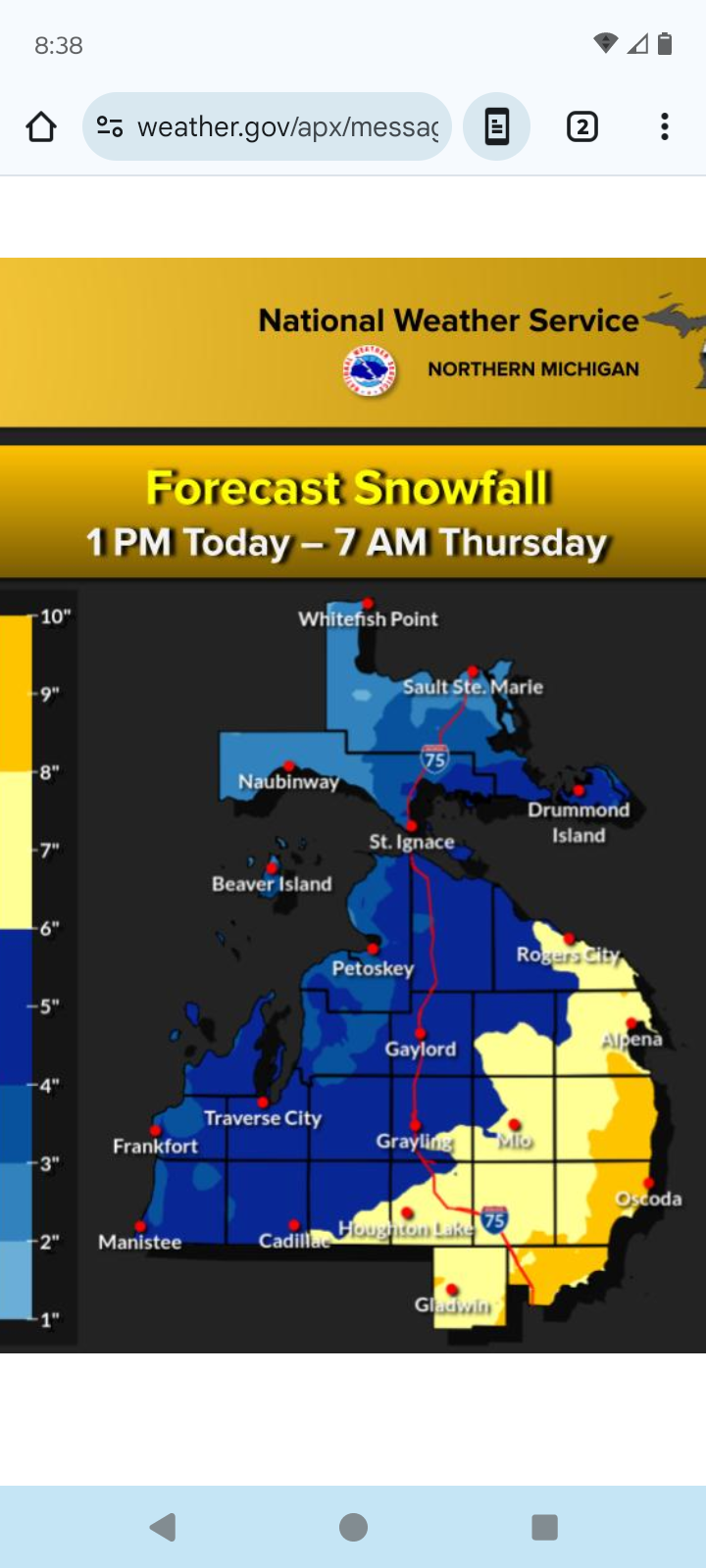
The NW trend might bring me the first 6"+ storm I've had this winter like most. Hoping for some easterly lake enhancement too off Lake Huron.I've been lucky to nickel and dime my way to about a foot on the ground so far. Gaylord,MI has had over 150" and Alpena 40" and is only 60 miles west out of the lake effect zone.Been riding my sled each day for about 3 weeks now so can't complain too much. Will be nice tho to not dig down into grass and gravel.
-
Winter 2024-25 Medium/Long Range Discussion
Imneversatisfied replied to michsnowfreak's topic in Lakes/Ohio Valley
Suicide weather here in Alpena,MI with bare ground probably for the next week or two I would have traded my white Christmas to still have the 4" of snow we had then now.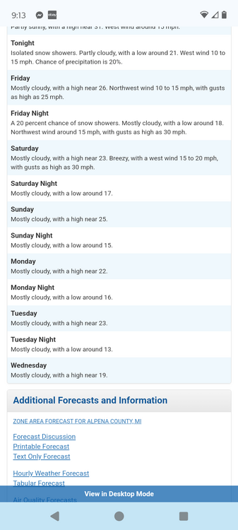
-
4/2-4/3 Significant Late-Season Snowstorm (WI/MI)
Imneversatisfied replied to Geoboy645's topic in Lakes/Ohio Valley
Everything but the kitchen sink coming down here in Alpena. Seems to have more snow mixed in during heavier banding. Winds E at 30mph. Already 1k without power. -
4/2-4/3 Significant Late-Season Snowstorm (WI/MI)
Imneversatisfied replied to Geoboy645's topic in Lakes/Ohio Valley
Cold,rainy,windy night for me. Could have have been a hell of snow storm... This one's going to leave me burned for awhile... Tonight Rain. Patchy fog between 11pm and 2am. Low around 36. Windy, with an east wind 30 to 35 mph, with gusts as high as 55 mph. Chance of precipitation is 90%. New precipitation amounts between 1 and 2 inches possible. -
4/2-4/3 Significant Late-Season Snowstorm (WI/MI)
Imneversatisfied replied to Geoboy645's topic in Lakes/Ohio Valley
Enjoy! Looking like a lil fun here in Alpena around midnight per mesoscale models. Fingers crossed for snow! Models are also showing a possible nice wrap around snow band Wed night here.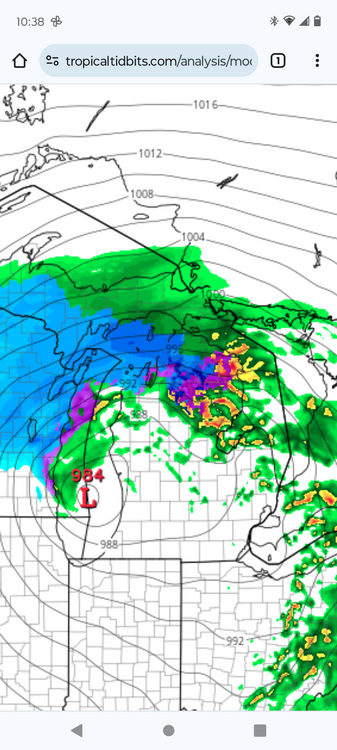
-
4/2-4/3 Significant Late-Season Snowstorm (WI/MI)
Imneversatisfied replied to Geoboy645's topic in Lakes/Ohio Valley
Everyone have fun that got surprised by the last minute west shift on this one,was really hoping for a big dog here in Alpena. Green Bay might steal it. Looking like 1-3" thru Thursday. Maybe the NAM will still reel this one in (shows 6")? Lol The heaviest precip comes thru in the middle of the night so that's a positive I guess. Still grasping at straws for colder than forecasted temps,dynamic cooling effect,an east,south shift, or some lake enhancement with the strong NE winds. I really wanna ride my sled one last time lol -
4/2-4/3 Significant Late-Season Snowstorm (WI/MI)
Imneversatisfied replied to Geoboy645's topic in Lakes/Ohio Valley
The 18z runs all seem to be holding their ground. Really sucks for me in Alpena as that bullseye was over my area in MI for 5 days on global models,then they shifted west last night big time. Mesoscale models continue east tho. Dare I hug the NAM ect??? Lol The rug might have been pulled one last time on me this snow season. Should be an interesting storm to nowcast!
-
12z Global runs maintain earlier west shift, mesoscale holds their ground east. Which ones will cave?
-
The models are not strong with this one lol
-
A whole state shift west? lol Hard to tell what's going to happen.
-
Seems like over night the long range models shifted Wednesdays storm west,vs short term models that hold onto the path shown by long range the past 5 days. Looking like anywhere between 2-18" lol Really hoping for one last 6"+ storm here in Alpena, Michigan.
-
Does anyone have access to the NWS blend model snowfall forecast for Michigan area thru Thurs? I'd appreciate it greatly if posted.
-
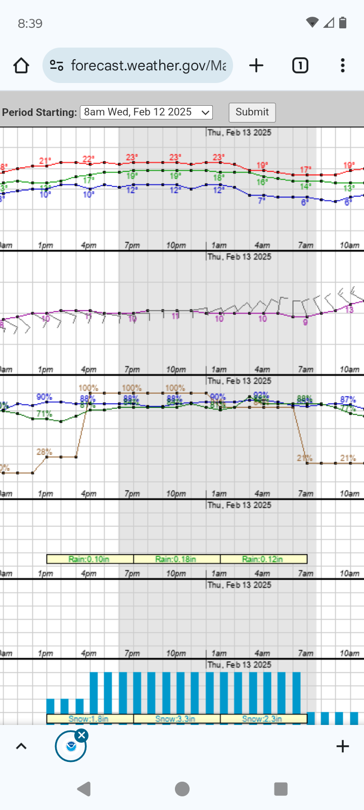
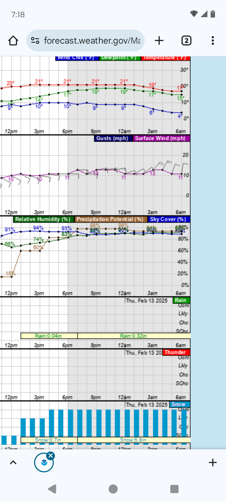
I'm still closely watching the Wednesday storm. Looking more and more likely that I will receive atleast 6" of cement snow to finish off the winter. NOAA APX is beginning to focus in on the potential. "Latest 00Z runs of deterministic guidance (GFS, ECMWF, GDPS) all depict a QPF bullseye of around 1.5 to 2.5 over NE lower. This reflects the enhanced lift from the upper level shortwave deepening the closed low as they meet and the wave rotates around the low. With this scenario, heavy wet snow is seen in model sounding profiles and combined with gusty surface winds." I'm looking forward to one last rip on my sled,then it's time to put it away and bring out my summer truck and car.
-
I've been doing the same for 3-5 days now. Past runs of GFS,CMC and ECMWF have estimated 6-18" accumulations for Alpena. Looking like one last potential for a nice concrete snowstorm and a rip on the old Yamaha snowmobile!
-
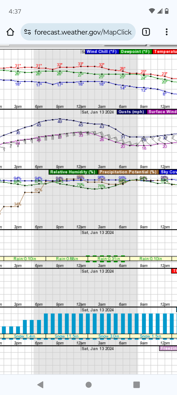
Well the storm definitely under performed in Alpena,altho it was pretty nasty last night for a couple hours. I'd say we got about 10" and 2-3' drifts. Could get a couple more inches thru Monday.
-
Storm is just getting going here in Alpena. Wind around 30mph and heavy snow on radar knocking on my door. Hoping for some thunder snow and crazy hourly rates. Forecast still calling for 12-18" and 55mph gusts.The fun begins!
-
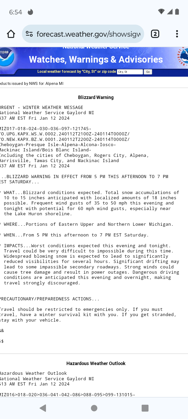
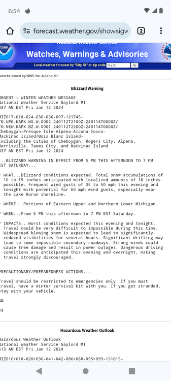
NWS APX upgraded Alpena to a blizzard warning. This could be epic! Too bad I hurt my back yesterday fixing my truck so I won't be able to enjoy it as much as I could. Hopefully I'll b able to snowblow myself out. I got nowhere to go tho thankfully.
-
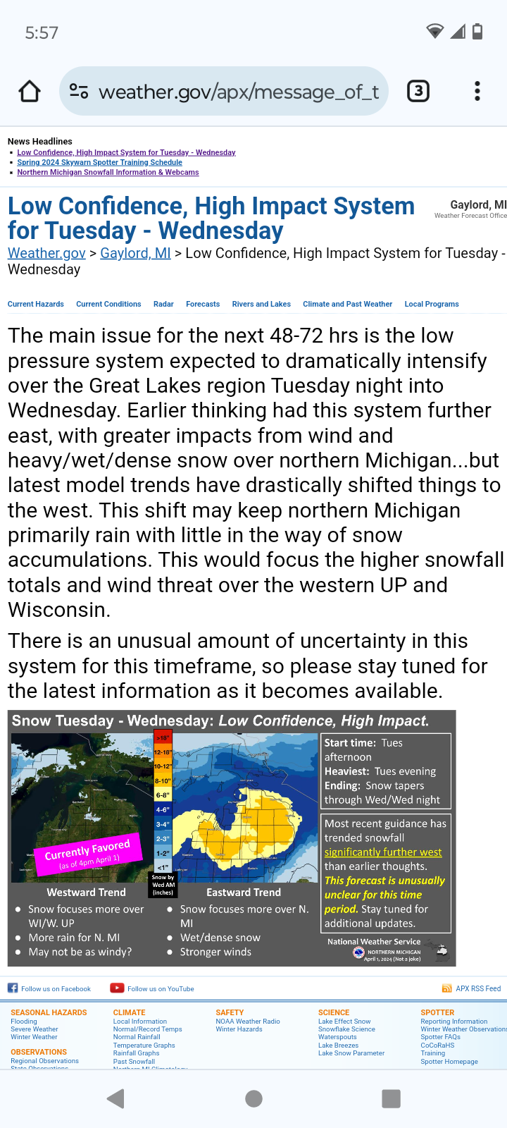
I can't recall a snow fall map with such high accumulations and 50 mph winds in my 37 years. I'll be posting pics and have a cam at my place and two at my parents about 10 min north of Alpena. Ready to be buried!
-
Looking like I could be in for a historic blizzard here in Alpena. Atleast a foot and 50mph winds. A storm of my dreams! Going to prepare tomorrow. Idk what to even expect for drifts!