Gino27
-
Posts
550 -
Joined
-
Last visited
Content Type
Profiles
Blogs
Forums
American Weather
Media Demo
Store
Gallery
Everything posted by Gino27
-
I'm afraid we got the ol 150 hour headfake
-
Most of us are in a good spot between the spread of Euro/EPS and GFS/GEFS given their typical biases. Modeling has still be terrible outside of 84 hours so I expect big changes still
-
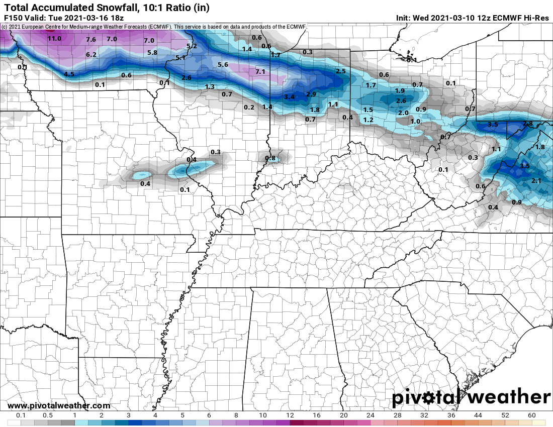
Euro comes way NW and puts the mix line on the wrong side of I-71 for a lot of us. Not sure if it's an amped bias or if we're in for another rainer.
-
Looks like the 2/15 sleet storm from last February. Still a long way to go.
-
It brought it back but with very different timing. Hard to believe what it's doing given the big system ahead of it. It is nice to see euro support from 12z however.
-
Models have a few things to be looking forward to in the medium range time: breaking down of the SE ridge, multiple waves of energy coming across to the east, and cold air in place. Thing is we're still gonna have to thread the needs to get snow imo.
-
Heh...
-
What is a snow?
-
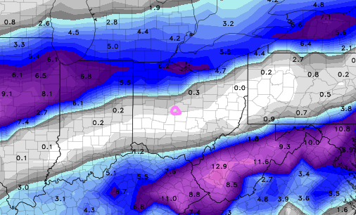
Sure looks like we could see a widespread dusting or maybe an inch. Ratios will be on our side but dry air will be hard to overcome.
-
Snowed fairly hard here at OSU. Had a coating on the grass but melted quickly. Loved the mood flakes!
-
Somehow managed 2.88" out of this thing. Thought for sure the majority of it would be north of me, 4.36" monthly total now.
-
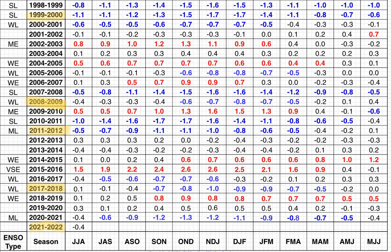
There's definitely a mixed bag of factors to deliberate about this winter for our area. Given this will be a 2nd year nina, there aren't very consistent analogs to compare from this standpoint. Obviously 2011-2012 was godawful, and that type of winter is certainly a possibility. Most of the other 2nd year nina's were close to, or just below average snow. In terms of what we can see developing now, there appears to be a SSW either ongoing or staring soon. This should lead to a weaker than normal PV overall, but it's clearly too early to how this will impact us. Another factor I'm not as familiar with is the cooling in the NPAC region. I've seen some mets point this out as a red flag for the east coast, but I'm not sure how it could affect us. Overall I think this winter will be warmer than normal with probably less than average snow, but not a complete torch/snoozer. Maybe Columbus will finally break out of it's "big storm" slump.

-
We had several inches of snow in late April last year
-
Seems like both euro and gfs want to bring the freezer back at some point.
-
Winter is trying to make it's annual comeback in April. Hopefully it doesn't stick around through May like last year.
-
ILN seems to think it's possible. Their watch is for gusts to 65 after the front and the AFD states, " The wind fields -- both in magnitude and expanse -- are concerning. The LL directional and speed shear is notable, yielding hodographs are long and somewhat curved. The main limiting factor for severe potential will be the lack of instability rooted near the surface, which may be rather limited except /just/ along/immediately ahead of and east of the actual sfc low track itself. This would support an environment where the greatest severe threat would exist immediately near/east of the sfc low track, which current model consensus would place mainly near/west of the I-75 corridor. This, of course, is entirely dependent on the track of that sfc low and the degree to which we can attain SB destabilization in the wake of afternoon activity. The profile will be very saturated, but very energetic. If even a little bit of SB-instby is realized, it would not take much at all for stronger cores to translate down some /very/ strong wind to the sfc."
-
Good times in here. Would y'all want an Ohio severe thread, or is there no interest?
-
This is part of what gets me. I started following the weather around 2008 and the 2008-2015 period had some pretty epic winters. In that sense I think we're all a bit spoiled.
-
8:30am, 40 degrees, sun is out... gonna lose a lot of snow and really feel like spring today.
-
I can't think of a better winter than this year realistically. Early start, Christmas storm, some awesome squalls, 2-3 big storms to track, 12" depth, and no extreme cold. Now add an early-ish warmup (not torch) with a slower snow melt to avoid flooding concerns, we're in a good spot. Big busts will happen, especially with our location/climate. Learn from them and move on. Edit: we also never had an all out mid-winter torch
-
My last HS baseball season gets underway tomorrow. 40s are greatly appreciated compared to some of the crap we've had in previous years.
-
You're not wrong about the storm track. It's VERY rare for SE michigan to be the jackpot, much like Central OH. We just haven't had ours in 6-7 years now, while you guys have had a few in recent years.
-
Idk about that. I don't know how one system could depress the SE ridge (that will inevitably show up) for the whole month of march. By mid month we should be looking at close to 50 for highs. That would be an epic cold outbreak to keep us that cold for the whole month.
-
The next few days look like end of winter's death grip that we've been seeing the last few weeks. Next week will feel really warm as we could tap into the upper 40s. With that taste of early spring we'll prob have snow in April and freezing temps in to mid-May like last year lol.