Gino27
-
Posts
550 -
Joined
-
Last visited
Content Type
Profiles
Blogs
Forums
American Weather
Media Demo
Store
Gallery
Everything posted by Gino27
-
I'm really worried about the icing potential in Columbus, at least from the gfs perspective. CMC and euro at least keep me mostly snow.
-
I had heard it's a model blend that mostly favors the euro. That would be the only model showing big totals this far south anyways. Still gonna take a lot for that to happen imo. Today's runs will definitely tell a lot of the story. Hopefully we keep seeing things move in our direction. Like we said above, it's been so long since a big storm for Columbus.
-
Not all that far off from what the euro just did. This thing is gonna change a lot in the next 3 days. I'm not sure I buy the anafront solutions to be honest.
-
2 pieces with a more eastern track with the second would be our best bet imo. Obviously hard to trust models with the big dog crushing the NE this weekend.
-
00z euro was as far SE as I see this thing going. Eastern ridge is just too strong despite the pressing from the north.
-
I think it was 2/21/2015. 6.8" at CMH.
-
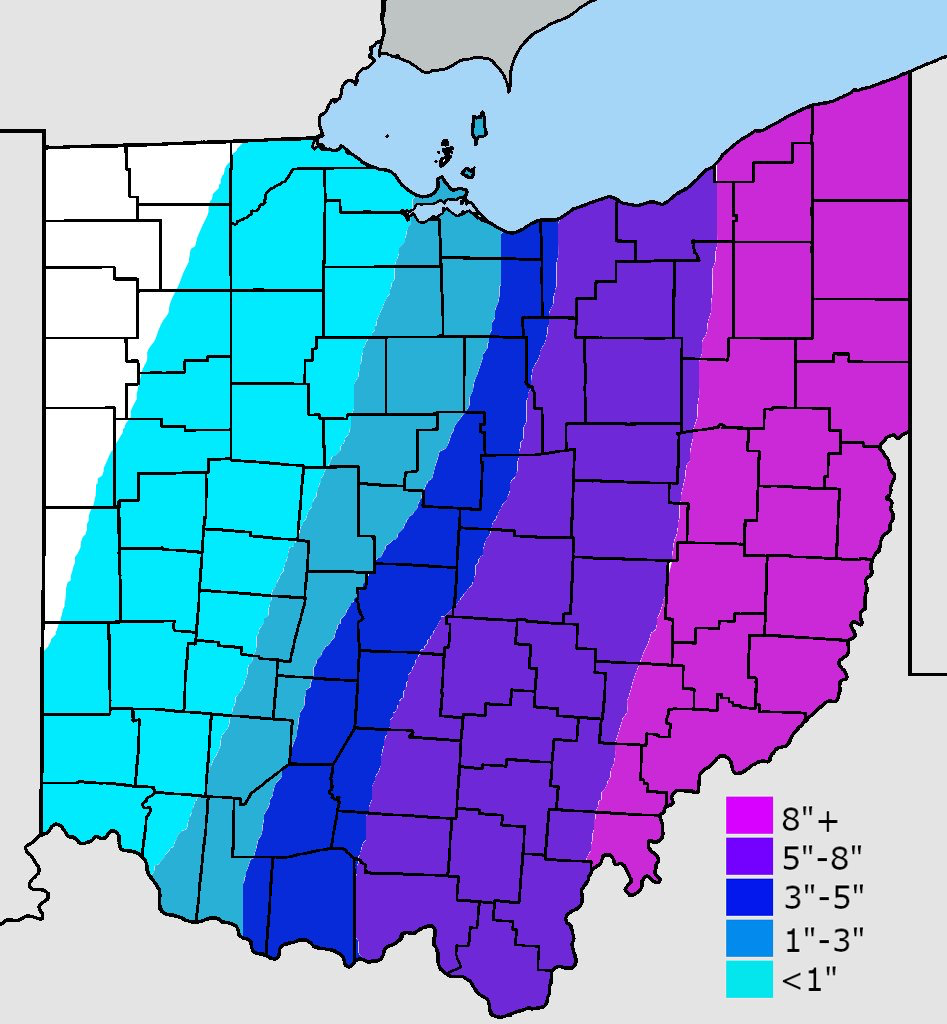
Looks like a very sharp cutoff on more significant snow totals. Franklin county could be the divide of a dusting and 3+ inches.
-
3” in Plain City. About the same on OSU campus. Definitely a nice storm given it looked like a miss just a few days ago.
-
here’s what I went with. Should do alright but could still see the western fringe being tighter

-
NAM coming in very nicely. I wonder how ILN and CLE will respond to this suite of models.
-
Yeah it's a possibility and it's what we're rooting for to happen. Need main wave to be just a tad slower and west as the second energy has been trending faster. Phasing looked best yet on this euro run, but it didn't translate down to the surface much like the NAM.
-
Boom potential is definitely there with the right band placement. We still convincing ourselves ULL's hold on longer before transferring compared to models?
-
Seems as if a tiny difference in the stream interaction (1-3 hours) is the difference between central Ohio getting heavy totals and almost nothing. Virtually no model is accurate enough to nail that down imo.
-
Sleet could be risk along and SE of I-71 IF things hold where they are
-
If we keep this momentum of ticking west, and phasing more with the shortwave (which the 18z euro did beautifully) I really like our chances
-
Nam is a disappointment
-
Euro doing the same thing as GFS. ULL sightly east, but more phasing and more precip to the west. If we could get that ULL to come a bit west I think a lot of us are in business.
-
Something to ponder. Compared to 6z GFS, which I think is what 12z nam initialized on, has the first energy faster and stronger than what is actually occurring. Is this what allowed the 12z Nam to phase more?
-
Only reassuring thing for Columbus area is that we only need about a 30 mile shift west to see some decent snow. That can happen all the way down to 24 hours before even starts.
-
Euro did some weird crap. Came west with precip but ULL was east. Tomorrow will be very interesting
-
There has been a subtle trend on all models to make the trough negative sooner which could help bring everything west. Time is on our side if that evolution wants to take place with new data.
-
Lol at the NAM. If only…
-
I’m definitely not a fan of recent trends. The ridge out west is much stronger and models are just starting to pick it up, which is forcing things east.
-
Euro crushes US-23 corridor
-
Even though there's really no blocking to keep this thing from going more west, I think a near miss to the east is most likely. I expected the GFS to start heading SE eventually.