

Gino27
-
Posts
550 -
Joined
-
Last visited
Content Type
Profiles
Blogs
Forums
American Weather
Media Demo
Store
Gallery
Everything posted by Gino27
-
Let’s talk winter!! Ohio and surrounding states!!
Gino27 replied to Steve's topic in Lakes/Ohio Valley
Sure enough later runs are going poof -
Let’s talk winter!! Ohio and surrounding states!!
Gino27 replied to Steve's topic in Lakes/Ohio Valley
Seems like a nice high ratio hybrid clipper is possible Thursday-Friday. Personally these are some of my favorite events, but with everything this winter I could see it going poof soon. -
Let’s talk winter!! Ohio and surrounding states!!
Gino27 replied to Steve's topic in Lakes/Ohio Valley
It just seems like each winter gets more futile than the last, but it also seems to all be bad luck. One storm goes east, the next to NW, and potentially one to the south feels like crappy luck instead of genuinely bad patterns. -
Seems the same in Central Ohio too. We haven't had a good I-70 track in too long.
-
Let’s talk winter!! Ohio and surrounding states!!
Gino27 replied to Steve's topic in Lakes/Ohio Valley
Even a sub 980 storm positioned just north of us will not have dynamics or moisture to support good snow around our area -
Let’s talk winter!! Ohio and surrounding states!!
Gino27 replied to Steve's topic in Lakes/Ohio Valley
It seems likely this one misses just NW and isn't strong enough to give us any backend snow. Then the follow up wave early next week gets suppressed... -
Let’s talk winter!! Ohio and surrounding states!!
Gino27 replied to Steve's topic in Lakes/Ohio Valley
Right now the shifts have been more to the NW of a lot of us. With two waves still being modeled beforehand, I imagine we will see a lot of shifting. With that being said we have all the ingredients for a big Ohio Valley storm -
Let’s talk winter!! Ohio and surrounding states!!
Gino27 replied to Steve's topic in Lakes/Ohio Valley
Potential is surely there with PV love and active pattern. Hopefully we can all cash in -
Let’s talk winter!! Ohio and surrounding states!!
Gino27 replied to Steve's topic in Lakes/Ohio Valley
The previously unmodeled shortwave that’s coming onshore around 6z Friday is spoiling the show. Doesn’t let the low amplify leaving us in the dry -
Let’s talk winter!! Ohio and surrounding states!!
Gino27 replied to Steve's topic in Lakes/Ohio Valley
Already scared it away -
Let’s talk winter!! Ohio and surrounding states!!
Gino27 replied to Steve's topic in Lakes/Ohio Valley
NAM pretty much on it's own with a little clipper Tuesday morning. RGEM gives Ohio a little bit of snow to start -
It has also been a lot razor thin cutoffs, especially in the last decade. Places just 20 miles N and NW of Columbus consistently get 6"+ while Columbus proper will be all rain or sleet. There might be microclimate reasons relating to the Scioto Valley.
-
The Appetizer: Light Snow general 1-2 " event 1/22-1/23
Gino27 replied to Baum's topic in Lakes/Ohio Valley
Been ripping here on OSU campus. Lovely overachiever -
Midwest/Ohio Valley/Great Lakes Snow January 24-26
Gino27 replied to Baum's topic in Lakes/Ohio Valley
Gfs run in a way reminds me of the 2/20/19 system. I got a nice front end thump out of that. -
I got down to -9.6° with 4-5”. Definitely an over performance.
-
-1 degrees and complete whiteout at my location. Doesn't look much better near campus.
-
Pre-Christmas (Dec 21-23rd) Winter Storm Part 2
Gino27 replied to Chicago Storm's topic in Lakes/Ohio Valley
20 degrees, winds gusting to 30, and ripping snow -
Absolutely ripping right now. Hope it keeps up
-
Changed over around 10:45. Been coming down good since
-
wow okay... even 3"+ with these winds will be impossible to travel in
-
Pre-Christmas (Dec 21-23rd) Winter Storm Part 2
Gino27 replied to Chicago Storm's topic in Lakes/Ohio Valley
We still have the triple threat of unforecasted warm tongue, sleet with surface temps of 12 degrees, and a fat 50 mile wide dry slot that are inevitable and Columbus gets them with every storm. This is why CMH hasn't measured >/= 6" from a single event since 2015. -
GFS is on it's own with that solution. I've seen a few meteorologists say that they think it's possible for a gfs solutions where the ULL closes off early and south, but we will have to wait and see. I'm still intrigued with every model really hammering down lower snow totals in the Scioto Valley. I know how valleys can funnel warm air and create a precip shadow, but it seems a bit overdone.
-
Watch area expanded and warnings for east central OH. Gonna be nasty...
-
Pre-Christmas (Dec 21-23rd) Winter Storm Part 2
Gino27 replied to Chicago Storm's topic in Lakes/Ohio Valley
Gfs gives me a nice reacharound band, but this has to be the most beautiful snow-hole I've ever seen modeled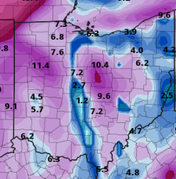
-
Way overdone, but of course I have to live right in the middle of the euro and gfs snow holes.

