Gino27
-
Posts
556 -
Joined
-
Last visited
Content Type
Profiles
Blogs
Forums
American Weather
Media Demo
Store
Gallery
Everything posted by Gino27
-
GFS ensembles continue to slowly tick west with the big NE storm next week. I might be able to sneak in a few inches.
-
Mine too. Would love to see it slow down a bit before becoming a coastal.
-
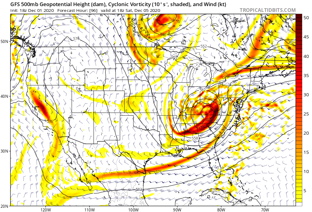
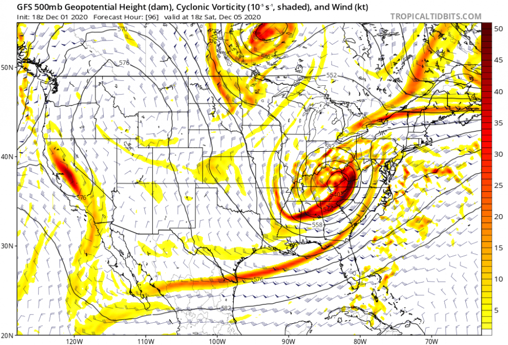
I mentioned earlier that big changes in the strat like SSW's that seem to always be pushed back by models aren't valid. GFS actually bumped this up a day. Will have to see what the euro and ensembles do. Certainly something to watch out for.
-
Big thing to watch is if the models keep moving the goal posts with them. If a SSW keeps showing up at the end of the run, it's not valid. If it gets closer as time goes on, it might be legit.
-
Far from over. Seems like most guidance is garbage outside of 5 days. Each signal has a chance.
-
Hmmm.
-
November 30-December 2 *Potential* Winter Storm
Gino27 replied to Hoosier's topic in Lakes/Ohio Valley
Rain/snow mix here in plain city. My station is reading 33.6 degrees when I was supposed to be around 38. Probably from the dousing of cold rain overnight. -
November 30-December 2 *Potential* Winter Storm
Gino27 replied to Hoosier's topic in Lakes/Ohio Valley
I still don’t get why ILN is only wanting to make maps for part of the storm, and going a bit low while doing so.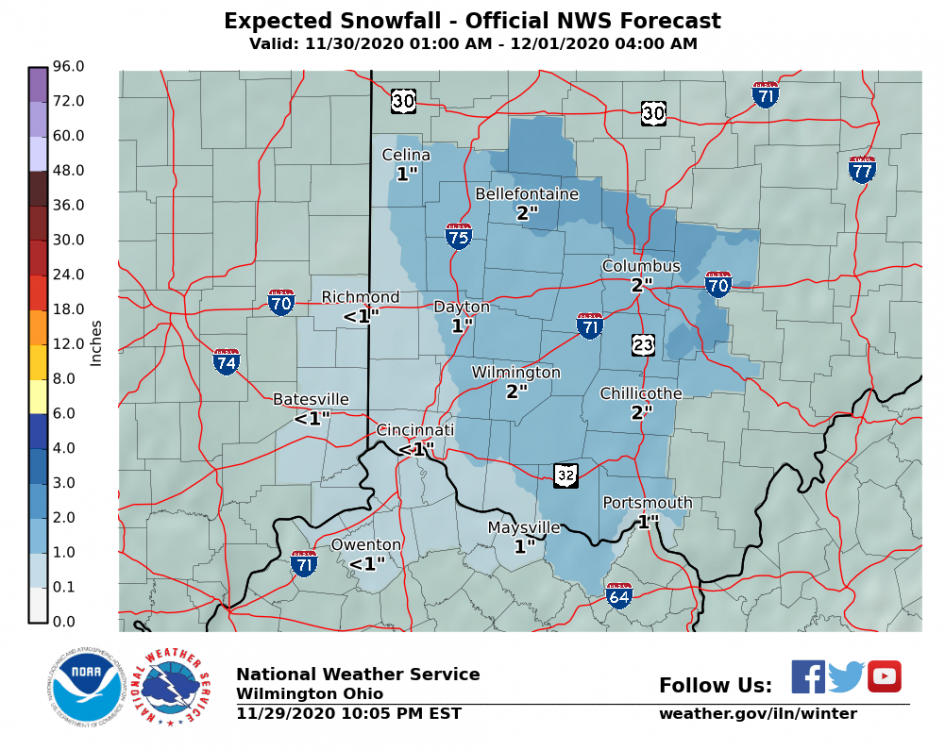
-
November 30-December 2 *Potential* Winter Storm
Gino27 replied to Hoosier's topic in Lakes/Ohio Valley
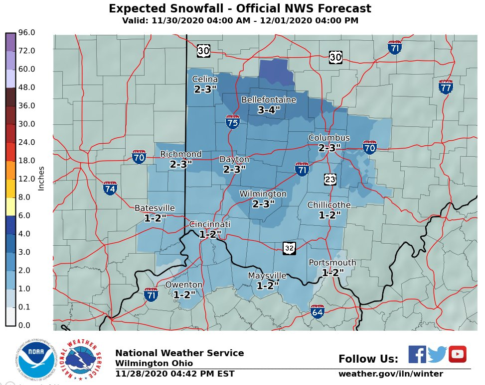
ILN still going very conservative. WWA for 2-4 inches even north of Bellefontaine, which they have a forecast of 3-7 for. -
November 30-December 2 *Potential* Winter Storm
Gino27 replied to Hoosier's topic in Lakes/Ohio Valley
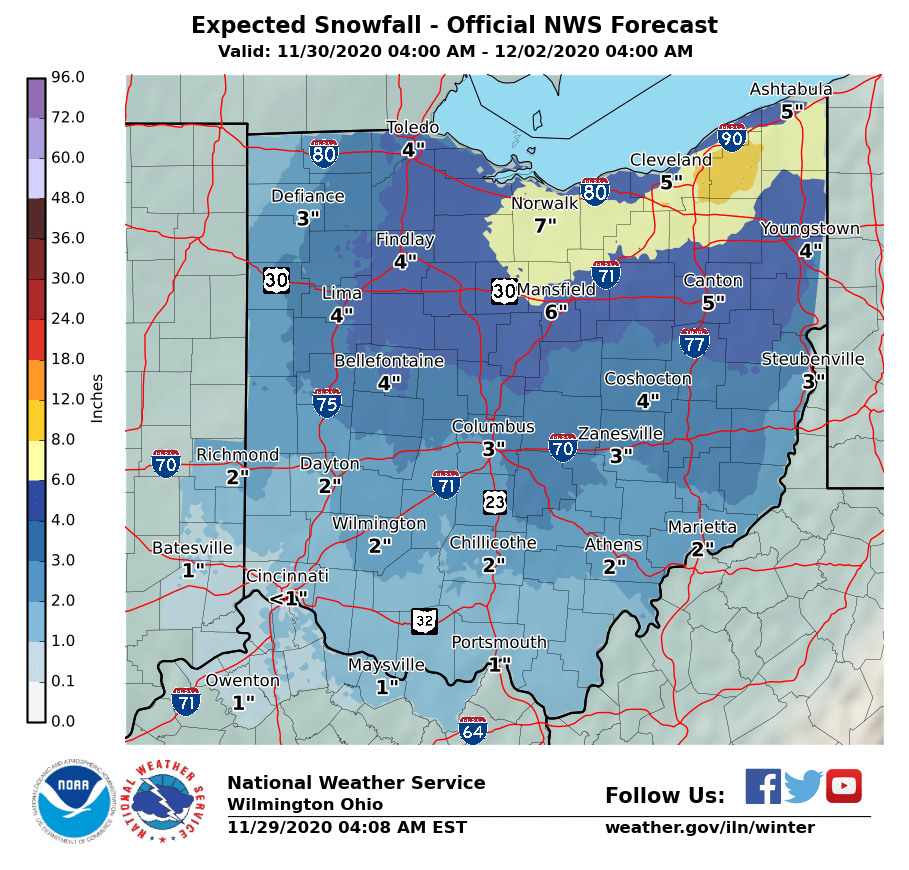
The difference between the offices is pretty astonishing. ILN put this "all of ohio" map out this morning, which is usually a mashup of ILN, IWX, RLX, PBZ and CLE. However, it's really obvious that IWX and CLE have much higher amounts for areas like Findlay and Toledo, along with slightly higher down towards Columbus. I'm sure they will iron these out today, but it's odd to see one office suggesting winter storm watches for an area while one county over an office think 3" max.
-
November 30-December 2 *Potential* Winter Storm
Gino27 replied to Hoosier's topic in Lakes/Ohio Valley
Definitely going conservative for now. I'm assuming they have the same low confidence as I do lol.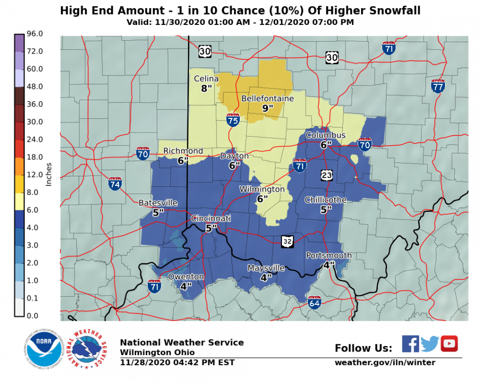
-
November 30-December 2 *Potential* Winter Storm
Gino27 replied to Hoosier's topic in Lakes/Ohio Valley
They just updated it to include the rest of Tuesday. This is either conservative, or genius. Time will tell.
-
November 30-December 2 *Potential* Winter Storm
Gino27 replied to Hoosier's topic in Lakes/Ohio Valley
ILN is also forecasting this as a two round system. There would still be a few more inches across the board after 4am. -
November 30-December 2 *Potential* Winter Storm
Gino27 replied to Hoosier's topic in Lakes/Ohio Valley
They love to bump up totals about 12 before onset. I’m really interested to see how much weight they give the gfs given that the other models are near warning levels for northern counties. -
November 30-December 2 *Potential* Winter Storm
Gino27 replied to Hoosier's topic in Lakes/Ohio Valley
I second this. Bellefontaine also has about 500ft of higher elevation so they may have less issues with accum. -
November 30-December 2 *Potential* Winter Storm
Gino27 replied to Hoosier's topic in Lakes/Ohio Valley
Our offices around here tend to be extremely conservative in regards to blizzard warnings. Big storm in January 2019 had conditions like what is expected for over 6 hours and ILN just did a WSW and mentioned blizzard conditions. -
November 30-December 2 *Potential* Winter Storm
Gino27 replied to Hoosier's topic in Lakes/Ohio Valley
Man I hope so. I've been screwed by just about every system since 2015. A slight jog to the east from what the Euro has been showing and I should do fine. -
November 30-December 2 *Potential* Winter Storm
Gino27 replied to Hoosier's topic in Lakes/Ohio Valley
Good Lord euro... -
November 30-December 2 *Potential* Winter Storm
Gino27 replied to Hoosier's topic in Lakes/Ohio Valley
Noticing 10:1 is coming in with lower amounts than kuchera. Not sure which is the best bet. -
November 30-December 2 *Potential* Winter Storm
Gino27 replied to Hoosier's topic in Lakes/Ohio Valley
ILN calling for "moderate accumulation" for everyone NW of I-71, but not ruling out a slower system with significantly higher amounts. -
November 30-December 2 *Potential* Winter Storm
Gino27 replied to Hoosier's topic in Lakes/Ohio Valley
Euro progressive and west. Not good for me at all. -
November 30-December 2 *Potential* Winter Storm
Gino27 replied to Hoosier's topic in Lakes/Ohio Valley
There’s always been some that look like that. I wouldn’t be liking these looks if I were in IN or western OH. -
November 30-December 2 *Potential* Winter Storm
Gino27 replied to Hoosier's topic in Lakes/Ohio Valley
Euro is much more progressive and doesn't occlude. -
November 30-December 2 *Potential* Winter Storm
Gino27 replied to Hoosier's topic in Lakes/Ohio Valley
Note on the AFD from Wilmington above. They are admittedly conservative on snowfall events. It's pretty significant to see them mentioning the potential for substantial this far out. -
November 30-December 2 *Potential* Winter Storm
Gino27 replied to Hoosier's topic in Lakes/Ohio Valley
Yeah I think that's the model trying to factor in the Scioto valley which tends to be warmer. It's a lot more SE of what the model shows. Canadian does the same thing.