binbisso
-
Posts
766 -
Joined
-
Last visited
Content Type
Profiles
Blogs
Forums
American Weather
Media Demo
Store
Gallery
Everything posted by binbisso
-
Definitely heaviest snowfall rates of the Winter here visibility has to be less than a 1/2 a mile Looking at radar and what has already fallen this easily would have been a warning level snow here if it happened that night or was a few degrees colder
-
Heavy snow Easily 1 to 2" an hour rates right now starting to stick on Paved surfaces closing in on an inch on Coldest surfaces
-
Special Weather Statement National Weather Service New York NY 1000 AM EST Wed Mar 9 2022 CTZ005>012-NYZ068>071-091700- Northern Fairfield-Northern New Haven-Northern Middlesex- Northern New London-Southern Fairfield-Southern New Haven- Southern Middlesex-Southern New London-Putnam-Rockland- Northern Westchester-Southern Westchester- 1000 AM EST Wed Mar 9 2022 ...SNOWFALL RATES PICK UP THROUGH THE MORNING... Snowfall rates will pick up over the next few hours and may become moderate at times reducing visibility to less than a mile. Little to no accumulation is expected on roadways. 1 to 2 inches of snowfall is expected on any untreated surfaces.
-
Yup coating on colder surfaces in Mt Vernon mod snow 32*
-
Most of Western and northern New England are well Below Seasonal snowfall so this is not your typical LA Nina which favors those places. Coastal New England and Eastern mid Atlantic were the jackpot zones this year.
-
Pivotal maps do not count sleet as snow. Take a look at the R GEM and the CMC. Mostly sleet for the sub forum and shows very little accumulation
-
Models trended colder On the overnight runs. Picking up on the low level cold air and high pressure now Is closer to northern New England. not sure how much snow falls but it looks mainly frozen from the city North and West the 6Z RGEM Has 1" LE falling as all sleet from the city North
-
2/13 Light/Moderate Snowfall Nowcasting & Observations
binbisso replied to Northof78's topic in New York City Metro
Add about 1" on pave surfaces and 3" on non pave surfaces around East Lincoln Avenue in Mount Vernon. Pave surfaces have all melted now snowing lightly still -
2/13 Light/Moderate Snowfall Nowcasting & Observations
binbisso replied to Northof78's topic in New York City Metro
About 3" in Mt Vernon. Looks beautiful outside. Snow sticking to everything. -
Snowing with a little sleet mixing and nice coating on the ground so far in Mt Vernon
-
Light snow falling here in The Bronx 30゚
-
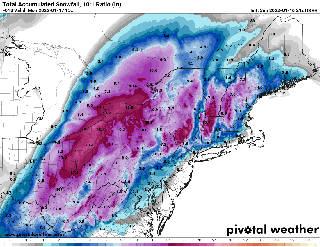
January 28/29 Blizzard Observations/Discussion/Nowcasting
binbisso replied to Northof78's topic in New York City Metro
Steady snow in Southern Westchester a nice coating so far -
UK just trended towards the nam
-
It did have its starting as snow for the 1st hour less than .1LE So it didn't show on the clown maps. However the 23Z shows .15LE falling as snow. I started snowing here at 6:30 still snowing moderately now a little over a 1/2 inch so far probably gonna end up with 1 to 2". Most models had me with nada including the uk GFS RGEM, gem and regular nam.
-
The 21z hrrr had 0 snow for me in so westchester. Newest run 1.5". It's starting to get a hint
-
Light snow has started in Southern Westchester County
-
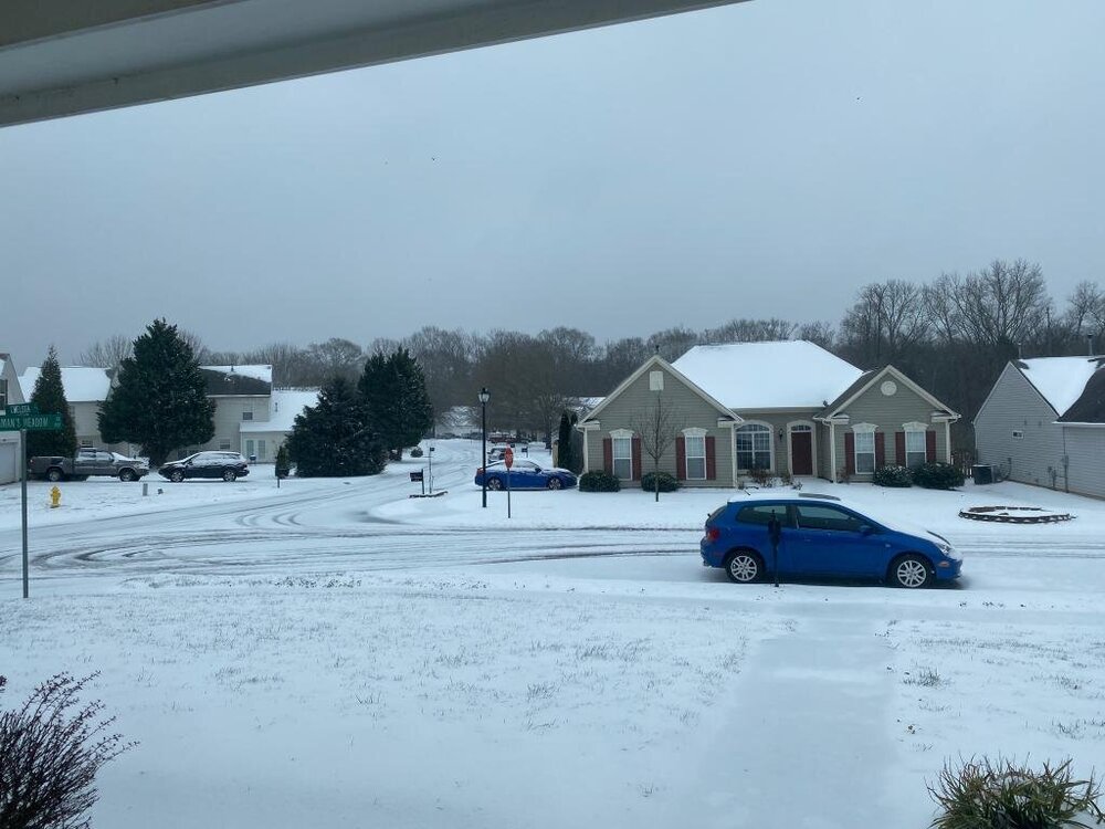
My sister in laws house Charlotte nc today
-
I love to see this. It could end up being an epic Winter for 75% of the US with northern New England being the worst in a moderate LA Nina

-
moderate la nina With above normal snowfall from DC through the Southeast, northern Gulf coast Tennessee, Kentucky. well below average snowfall for northern New England england I guess Snowman 19 would have predicted that
-
I wonder if those weak lows well out in the Atlantic missed the phase with the northern stream. There's about 10 members that look like it would have minimal to no impact to our area. I think that's the piece going forward we have to look for when where and if the northern stream phases in
-
Yup you now have about 1/3 of the Members over the Atlantic compared to 12Z when there was 2
-
Is it possible that the shortwave phasing on the back side of the low causing it to go due North from the carolinas Slows down and the phase never occurs? Will this cause a possible colder and snowier solution?
-
@snowman19 my deepest condolences for your loss. I lost my wife to breast cancer 10 years ago. It's a devastating illness. Hopefully they find a cure.
-
In wake of polar trough, northern stream upper flow will dominate mid to late week with E US trough amplifying in response to a series of shortwaves moving through the flow. The shortwave energy of note appears to be NE PAC origin, diving towards the SE US coast for midweek. General agreement with this energy being the catalyst for northern and southern stream phasing Thu/Fri with development of closed low upper low and strong low pressure off the SE US coast. At this time, model consensus is that that this phasing will take place too far east in a progressive flow, keeping developing low pressure well east of the region. Since this is still 5-6 days out, with these interactions inherently tough for models to resolve, something that bears watching through the week for development and track closer to the coast. Otherwise, locally just a weak and dry frontal passage on Thursday in response to digging and eastward translating northern stream trough.