

Rhino16
-
Posts
1,705 -
Joined
-
Last visited
Content Type
Profiles
Blogs
Forums
American Weather
Media Demo
Store
Gallery
Everything posted by Rhino16
-
Already 32.6 at Canaan NWR. Fast! It was 37.3 this time yesterday.
-
It’s already 40.6 at Canaan NWR. 50ish at surrounding mountaintops it seems.
-
If you haven’t decided yet, today looks okay for a clear night sky, at least according to the HRDPS which is apparently a decent model for cloud cover which I’ve heard in space weather groups. Satellite also seems good at the moment. Good luck stargazing.
-
Happy birthday!
-
Unidata has a series on their youtube channel where they show how to retrieve data, manipulate it, plot it, etc. It’s all in python though, but maybe it would help.
-
I just graduated from the VT Program, and am considering returning for masters in an adjacent topic. Your ideas seem to be the profs current thinking at the moment with respect to AI. I’ve heard from numerous people that the field is shifting towards a model where meteorologists will be interacting with the public much more, instead of sitting at the forecast desk all day, at least in the public sector.
-
Thanks! Ha, Thanks! I’ll be back tomorrow…
-
I’ve gotten older again. This time, I’ll get to go around the sun as a meteorologist. Let’s see what I’m doing this time next year…
-
A quick rain shower over the northern neck. Maybe it will add half to 3/4 of an inch or so. It was coming down. Wonder if they’re using some CAPE from the bay to sustain themselves.
-
Radar might be covered in outflow boundaries to the south later. Maybe there will be some cool collisions to see.
-
 Mine is probably impossible to achieve.
 -
Managed to mostly split the gap earlier, but did get maybe a 0.1” from the south half of the line. Got to see 2 small shelf clouds though, and lots of lightning. Getting random showers now with some rumbles. Waiting for the random beginning of august impressive unexpected thunderstorm.
-
Are there any good resources to learn little things like this, or is it all just time, experience, and networking? It feels like there’s still so much to learn. I should practice forecasting while I’m not doing anything.
-
Not a drop today, kind of disappointing when the air is a liquid.
-
DCA: 99 IAD: 99 BWI: 99 RIC: 101
-
We’ll probably have to wait for a substorm tonight for best chances.
-
Tomorrow night seems to be the one to watch. Won’t complain if it continues into monday night.
-
We haven’t had much interesting that hasn’t been timed alongside clouds and rain so I’m hopeful this time will be good.
-
Did get some good storm photos yesterday! I was quite surprised. Sunday and Monday may be chances to see Aurora if the air can stay clear.
-
Not many changes at 20z, just some adjustments north and “trimming”. rest of outlook is same as previous. ...20Z Update... The primary change to the Day 1 Convective Outlook was to slightly expand severe probabilities farther north in NJ to account for placement of stronger storms likely preceding the surface low track. The western bounds of severe probabilities were also trimmed to account for the passage of the surface low and surface cold front. Otherwise, the previous forecast (see below) remains on track. ..Squitieri.. 05/30/2025
-
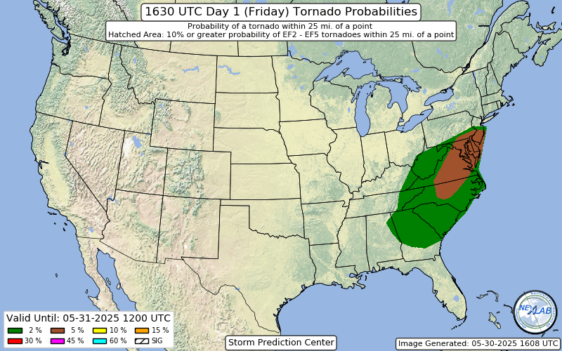
Very big expansion of the 5% Tor in the latest outlook…
- 1,378 replies
-
- 5
-

-
- severe
- thunderstorms
- (and 2 more)
-
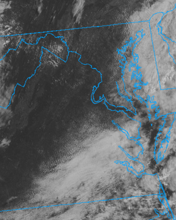
Reviving this thread, maybe it’s better to make a new one soon, or we can see how long this one can persists. I’m a little more interested in today. I think I can see some hints of instability on the northern edge of the cloud cover, and mesoanalysis indicates we have about 500 j/kg of CAPE over the area. I’m still waiting for the clouds to leave, it’s 69/67.
-
A lot of guidance has the classic gap that opens up just west of Richmond and continues to the coast. Not sure if that’s because of the rain the models want to send through early morning, or some other phenomenon, but it’s annoying to see instead of something to break up the cloudy days.


