Prospero
-
Posts
1,162 -
Joined
-
Last visited
Content Type
Profiles
Blogs
Forums
American Weather
Media Demo
Store
Gallery
Everything posted by Prospero
-
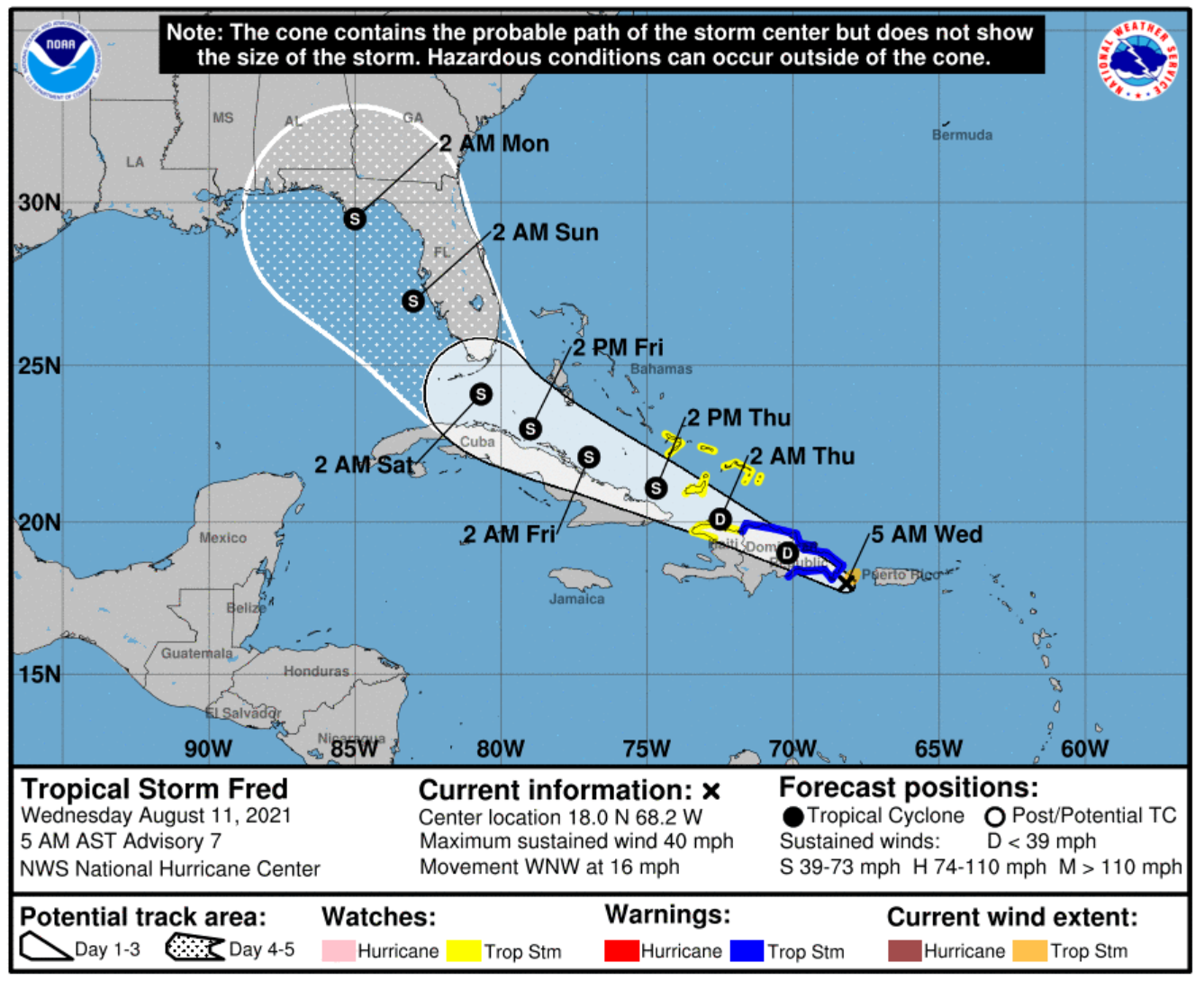
Sorry, but for whatever reason this thread is slow for mets right now. Waiting for Fred to do something I guess... Normally it is not like this when a storm is coming. Be patient.
-
The Hwy 60 Causeway is always a local news video shot during a storm; waves crashing over the road, etc. I was on Clearwater Beach when the strongest Hurricane Hermine outer band hit from many miles out to sea. My wife here in Gulfport called and told me a tree fell on our house and I was trying to get home. That was likely my most intense "Hurricane drive" ever for me. Getting out of Clearwater Beach in flooded streets and the drive across Hwy 60 with the surf splashing onto the road to the mainland was scary, and even the drive down Alt 19 inland was a wind and rain adventure I'll never forget with many lights out and debris on the road. But by the time I made it home the band passed and the rest of the night was not quite as intense, but still kept my eyes open. BTW, there is a Mellow Mushroom pizza on 60 a few blocks from where you will be working. Love that place.
-
May I ask? Have you ever experienced a tropical cyclone (Tropical Storm or Hurricane)? If not, even a moderate Tropical Storm will be something you'll never forget. The sustained winds, pounding sideways rain, the surf breaking and blowing over seawalls, palm fronds flying in the air, power going out, etc. For we who live down here in Florida who have homes and businesses that we cannot pack up and run away during a storm, we ride them out. For chasers who are mobile, even the worst hurricanes you can "get out of the way" in a reasonably short notice, even in traffic on bridges. So you should aim to be in the heart and core of whatever Fred might do, and if two or three hours out it looks really bad (cat 3 or 4), head inland or a few miles north or south. You likely won't be in danger unless you are foolish and ignore the obvious. But you won't need to worry about that with Fred, I am confident. Try to be where it will be the worst, get your money's worth on your trip to Florida. No matter what, chances are you will not be in the exact right place. That said, even being anywhere in a tropical cyclone is very impressive. You will "feel" it, these storms have a feel that is unique. The awesome power is not like anything else in the world. Watching clouds overhead move quickly, the wind on your face, the palms bending (which they evolved to do), everything is amazing. Enjoy! Side note on my previous whiny email about not getting rain in Gulfport. We are getting it this time, sideways. Third night of crackling lightning and thunder, a 60 mph gust recorded and mentioned on the local news. (My dad in assisted living a couple miles away just called panicking thinking Fred was here! LOL) Uh oh, power blinking again. Been a few years since we've lost power, and the past three nights our areas has been out. Debris in the yard which is good as it helps to prepare the trees for a storm IF we get one.
-
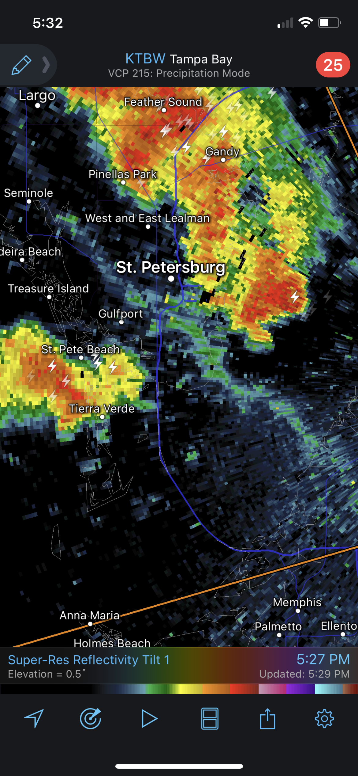
You know I always whine about storms "parting" when they come by us in Gulfport. I've lived here for 18 years, there is some kind of natural reason why these storms part over us. Not always, but most of the time. See radar image below, yet another line of storms parting over Gulfport. We may still get hit, sometimes we do. But usually we see rain a few blocks to the south and a few blocks to the north. We do get the lightning and wind which is exciting, but wish we got all that rain too!

-
As a "storm chaser", I doubt you have anything to worry about. In fact, you will be scrambling to find the very best and most intense affects you can find. You've watched the Weather Channel, right? If this keeps tracking west, you might want to head to LA... Personally, I wish I was chasing tornadoes in the Midwest myself.
-
And you could have a two day adventure. South Florida Saturday morning, then after it passes head north to Pinellas County for a Sunday morning chase. Our beaches start on the south at Pass-a-Grille which is a cool place to watch a storm. It is low elevation so gets some flooding, lots of beautiful palm trees that sway in the wind, and plenty of good beach access. Then north there is St Pete Beach, Treasure Island, Indian Rocks Beach and Indian Shores, Redington Beach, and of course Clearwater Beach. If it is a Tropical Storm right here in Gulfport is a great place. We are not on the Gulf of Mexico, we are on Boca Ciega Bay. Our cool little downtown gets flooded with every storm and it is a popular place for local news to visit during storms just because it always looks worse here than anywhere else. If you think you might come up here for the Sunday morning chase, you might check out rooms and there are plenty with beautiful beachfront views. You'll find great food all up and down the beaches, even during Tropical Storms. Sometimes my wife and I stay at Island Inn on Treasure Island. It is inexpensive, has great Gulf views, comfortable, clean, and would be a perfect basecamp to travel up and down the beach looking for best storm shots. And its a 15 minute hop to Gulfport to see flooding at high tide. Island Inn - Treasure Island Good luck!
-
Stay up on warnings and evacuation orders: "If an evacuation is ordered, there will be a steady stream of traffic leaving the Keys. If you travel to the Keys, you will be required to leave. Furthermore, most, if not all visitor facilities will not be open, as their owners make hurricane preparations. Buildings will be shuttered. Boats will be secured in protective moorings. State and county parks will close. So even though in the early stages of an evacuation, visitors may be able to reach the Keys, they will not enjoy the traditional benefits of a Keys vacation. It’s best to reschedule travel plans to visit after the potential danger has passed." Have a backup plan on where you might want to go. Of course, if there is no storm or evacuation, enjoy the Keys!!
-
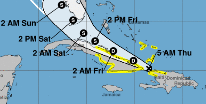
They slowed down the timeline a little. If anything comes of Fred we'll likely be experiencing in daylight hours which is a treat for a change. Seems like the last few storms around here have been in the middle of the night. If Fred becomes a substantial storm, it might be hard to get to the keys if they close traffic to visitors. You could always drive up here to Pinellas County and give Fred another day to strengthen. We have lots of beach areas.
-
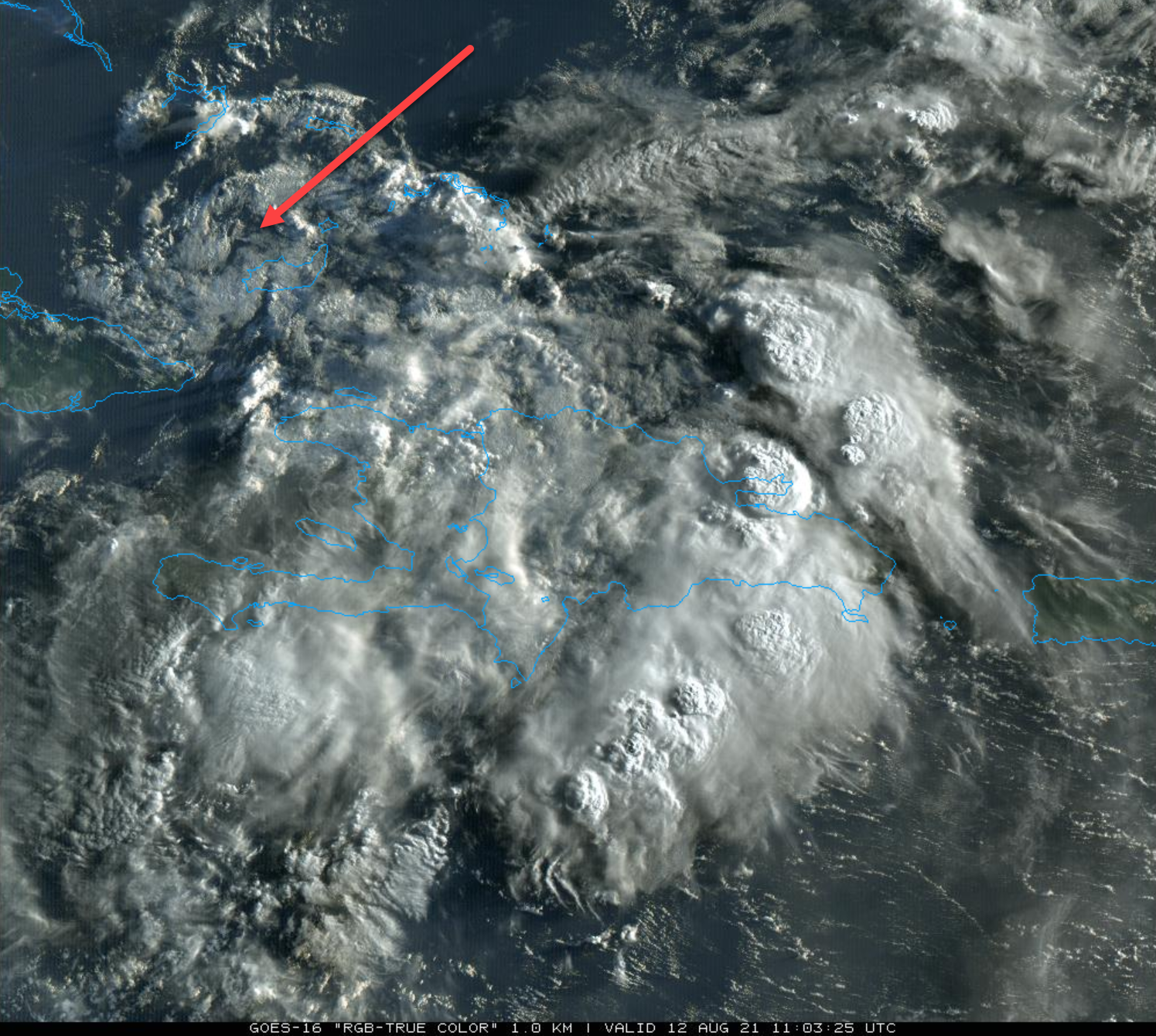
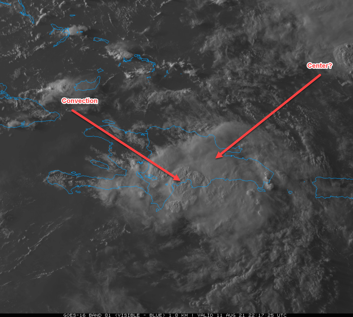
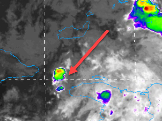
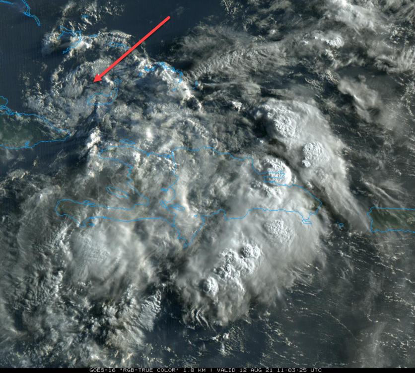
However, where the latest NOAA track shows it is a ways west of what I am looking at (red arrow) where there is small blob of convection firing up on sats.
-
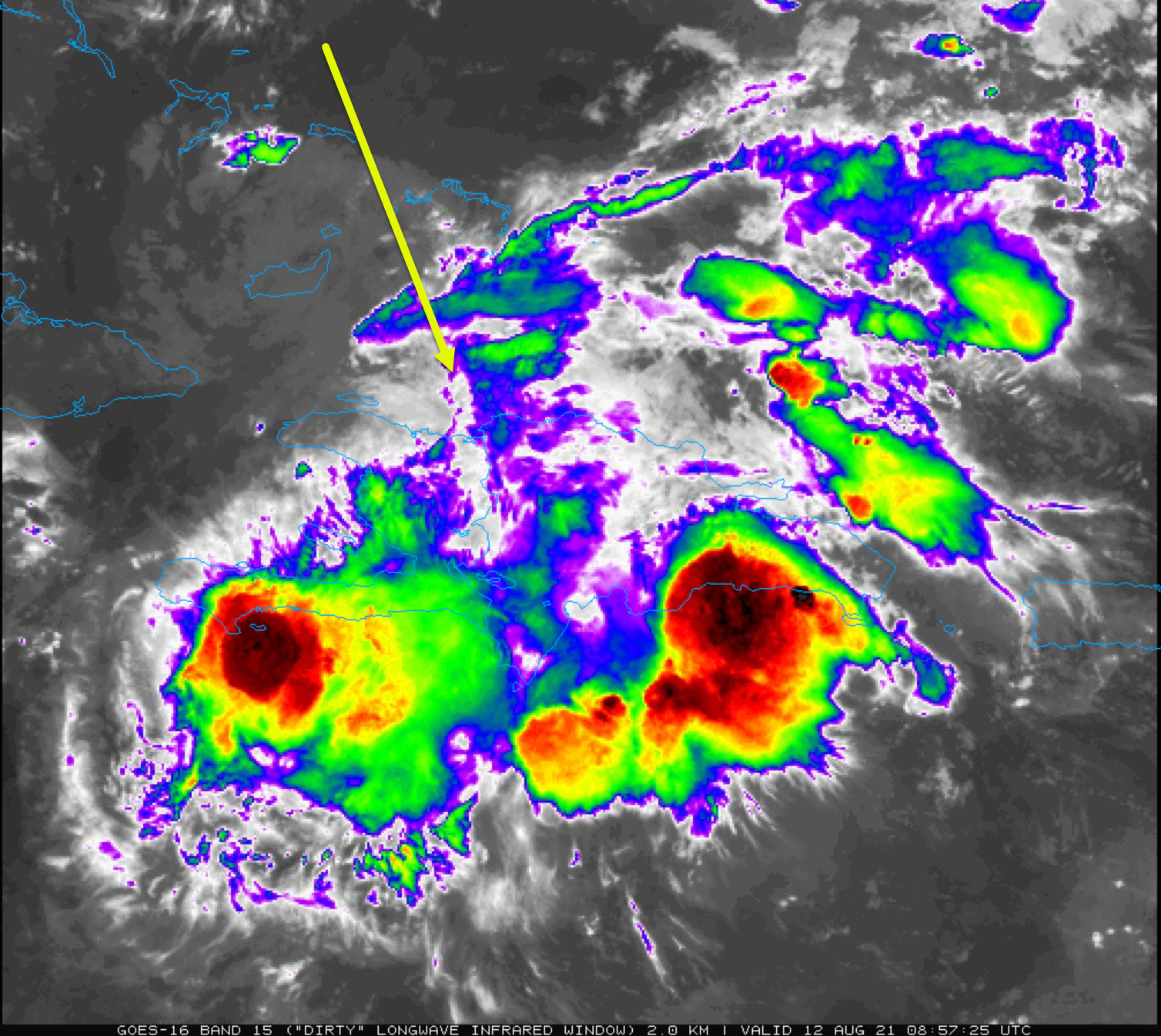
I'm going back to the idea that the large beautiful swirl we are looking at is NOT Fred's LLC and that it is where the NOAA says it is south of Inagua. I can see it, very small, not impressive but will be watching it. The large swirl may just blow away doing nothing.
-
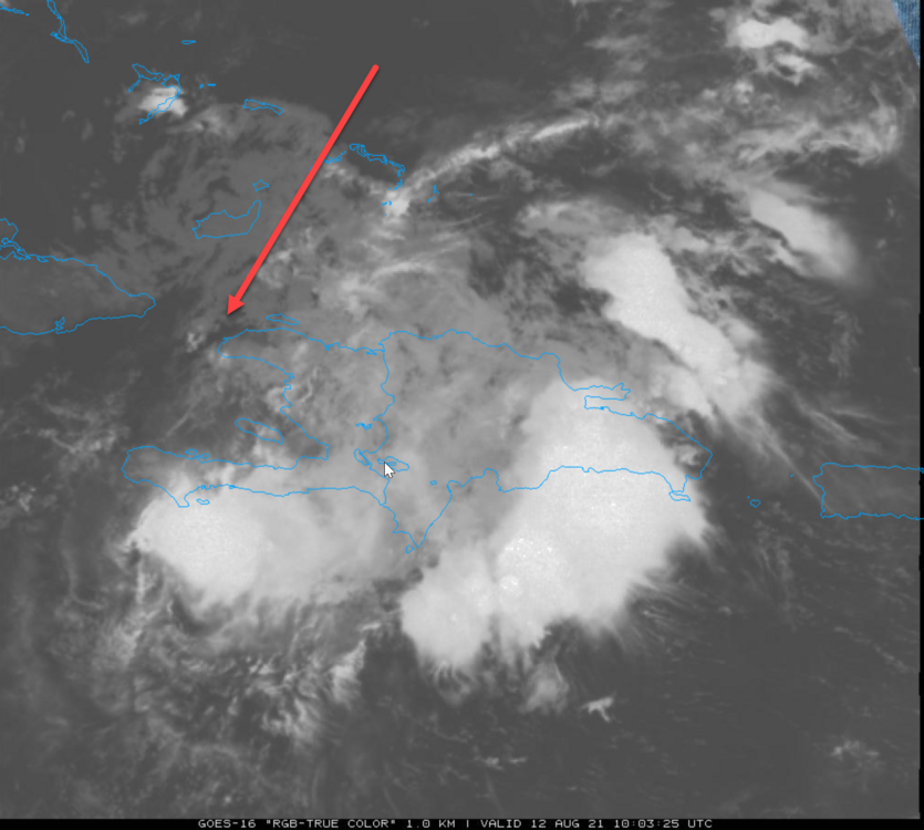
Sure looks like it. If it is, it looks fairly well defined as well.
-
With the visible starting to show it is easier to locate. Doesn't look like much.
-
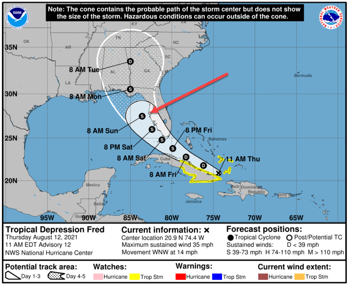
Yea, I figure I am too far to east, but can see a spin there. NOAA has it just off the tip of Haiti south of the Inagua Islands:
-
Fred's not dead. Maybe beat up a little. One can make out a little circulation on the IR animation. It may not be directly over the LLC though.

-
Perfect for now. Bedtime, getting up at 4 am. My wife is a teacher and I get up with her. I'll wake up around midnight and grab my phone to see the latest NOAA advisory and see what happens here. I'm not expecting anything much until tomorrow afternoon...if even then. But hey, you never know what Fred might do. "Yabba-Dabba-Doo!"

-

2021 Atlantic Hurricane season
Prospero replied to StormchaserChuck!'s topic in Tropical Headquarters
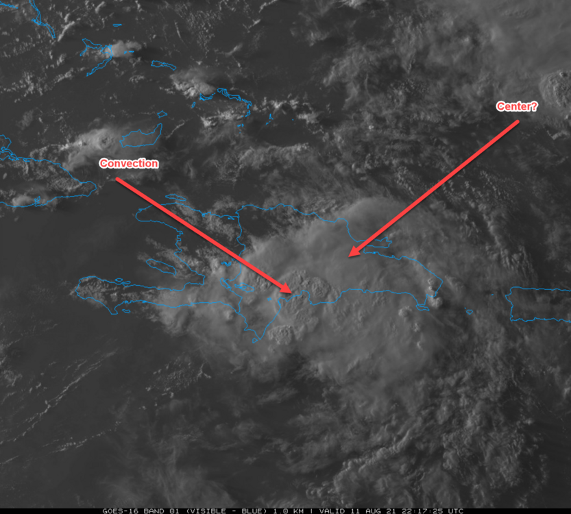
OK, a rerun due to popular demand... What will this one do over the mountains??
-
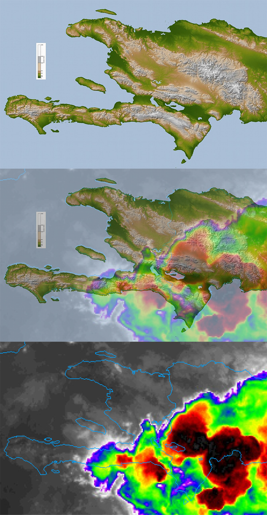
Especially if the center is more on the north side of Hispaniola which it might be. Part of my frame of reference is when a low fed by monsoon or Gulf moisture hits southwest Colorado and snow piles up very deep on the front range fairly far away from the center of the low. So the convection on the southern side of this island's mountains to me could be just the pile up of moisture and energy being squeezed out by the elevation while the center is on the other side of the mountains. I AM NOT A MET (disclaimer)
-
Yes, we get storms. But sometimes they have qualities that are a little different. I guess you have to be obsessed like me to notice, and I can say in my backyard the last two nights I've watched more intense lightning than the past two years at least, maybe conbined. Last year was a lightning dud at our house. The "thunderstorm" season came and went very disappointing to me. At risk of being kicked off for off-topic, when/if Fred fires up I am ready to post my dribble on a Fred Banter thread. As always...
-
Here's a graphic I just made for myself, not being totally educated on the mountains of the island. The convection is in the valley. But one lesson over and over, and over again the past couple years I have been here is that convection is not always where the center of the storm is. Deceptive way too often. At this moment I am catching up for the day, yet trying not to fall into the "convection burst" excitement I have typically enjoyed too much. Even seeing an "eye" that seems to want to appear. But the graphic shows the terrain and where the current IR overlays.

-
OK, can anyone tell us which arrow is closer the whatever is the center?
-
We are in our second evening of the same. At least this time we are getting rain here in Gulfport. Last night, which is typical for whatever reason, the storms part and it rains north and south of us. So last night with the most intense lighting storm in a couple years or so, very intense, the strikes were hitting dry targets so instead of the electricity running on the wet outside of whatever they hit they went right through the center blowing up whatever it is they hit. Thus our area was without power for several hours (near 20K homes very quickly). I was standing outside watching. Scary! Saw the fat bolt that kicked off our power. It hit a block or two away and the thunder was simultaneous. Made me jump, could smell ozone. The neighborhood went silent, so no more humming, buzzing, nothing. Thunder and sirens were the only sounds for an hour. It did finally rain lightly after the storms drifted off the coast, 0.15 an inch. Yes, there is energy built up, and the Gulf of Mexico needs to release some tension as well. Will Fred be the one? Who knows. Will it even be this year? Who knows. But the energy is there and needs a release.
-
Well, not sure I am in the "rest of you", but being a newbie on the internet at times since 1995 or so on countless forums, and on this storm forum for over two years, I believe (paying some $$$ dues as well), I might be. If not, at least I am a very passionate outside the rest of you who might be a dumbass at times, but having as much or more fun than anyone. I was on the road all day which is fine. I knew Fred was inching its way over the island so didn't worry about missing too much. It would have been a tedious day to wait for every new sat image to appear, and even though checking here on my phone, not much has changed since early this morning. In fact, likely a long night ahead too without any startling new developments. I will wake up in the middle of the night and check though, of course. That said, it is exciting in its own way to see if Fred survives the hike over these mountains. Are many of us NOT sitting on the edges of our seats waiting? Can't wait for morning to see what happens!! I don't recall any storm being destroyed on this trek over Hispaniola since I joined AmericaWX in the 2019 season. Anyone remember differently?
-
Don't jinx us!
-
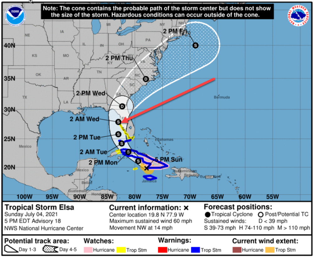
Starting to figure some preparations into my schedule. Maybe even a little shopping today. Reminds me a bit of Elsa, at least in relation to Tampa Bay (July 4 at 5PM): Elsa was a "Hurricane" when it passed very near us on July 6 yet it was not much of a storm here. Seriously, a substantial Tropical Storm in the same place would be much more of a concern, and Fred might be setting up for that if it survives the mountains. (Just scanned the Elsa forum and it is funny how similar all these storms forums become! LOL)

-
Power is out here due to lightning, best lightning storm all season. So we have a taste of what can happen during tropical systems. Half hour and already stuffy and warm inside! Good thing for tablets and smart phones can still follow discussions. Lol Duke Energy says back on by 12:30 am.