Prospero
-
Posts
1,162 -
Joined
-
Last visited
Content Type
Profiles
Blogs
Forums
American Weather
Media Demo
Store
Gallery
Everything posted by Prospero
-
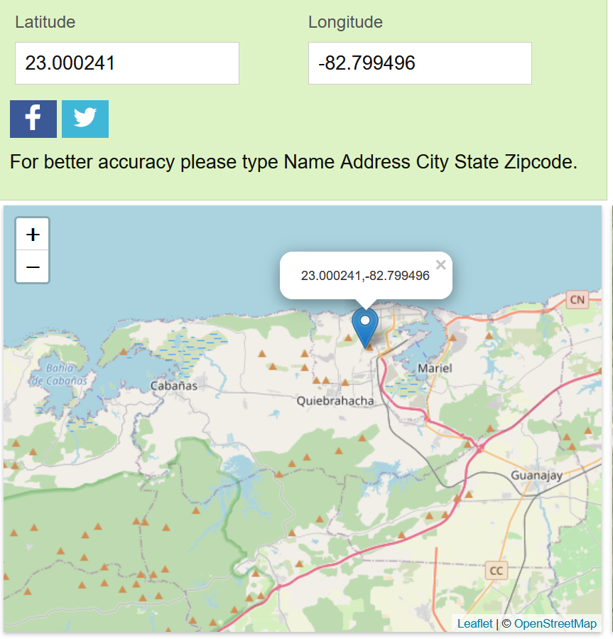
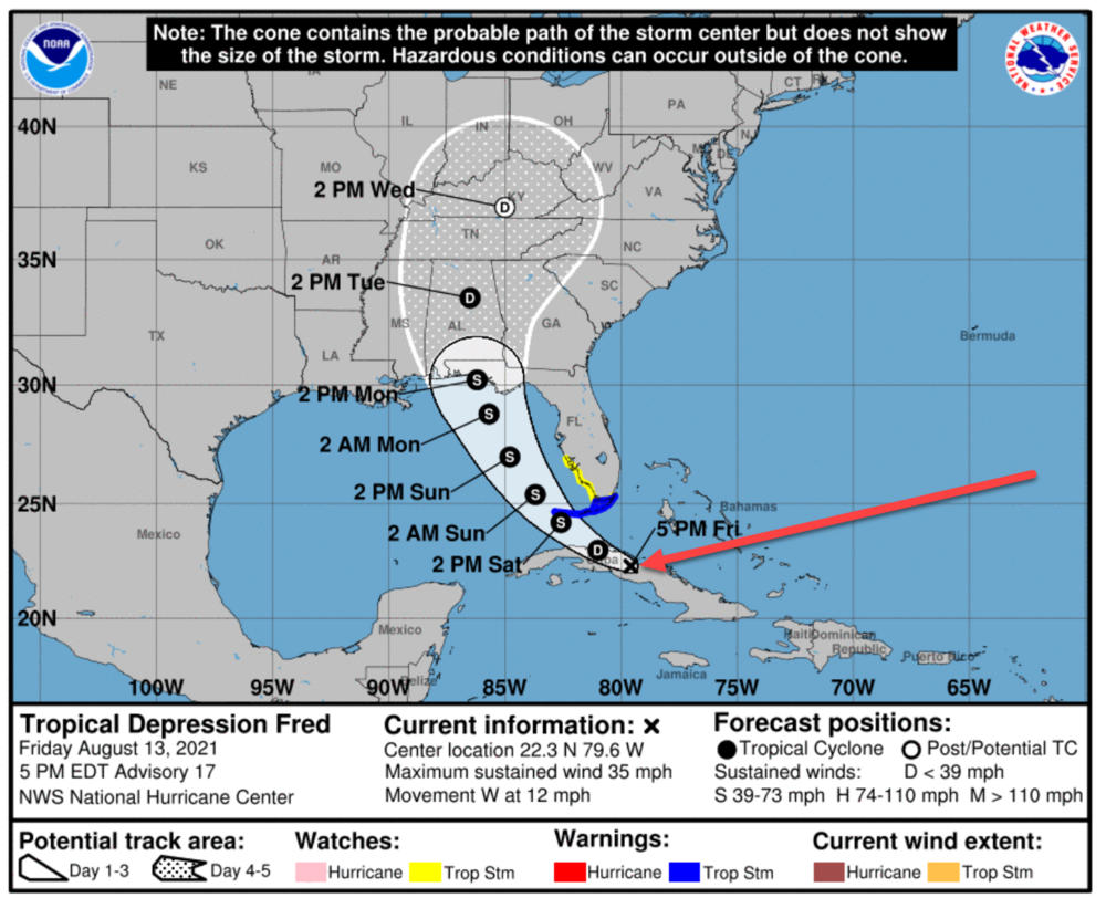
Or according to the NOAA at 8 am it is right about here:

-
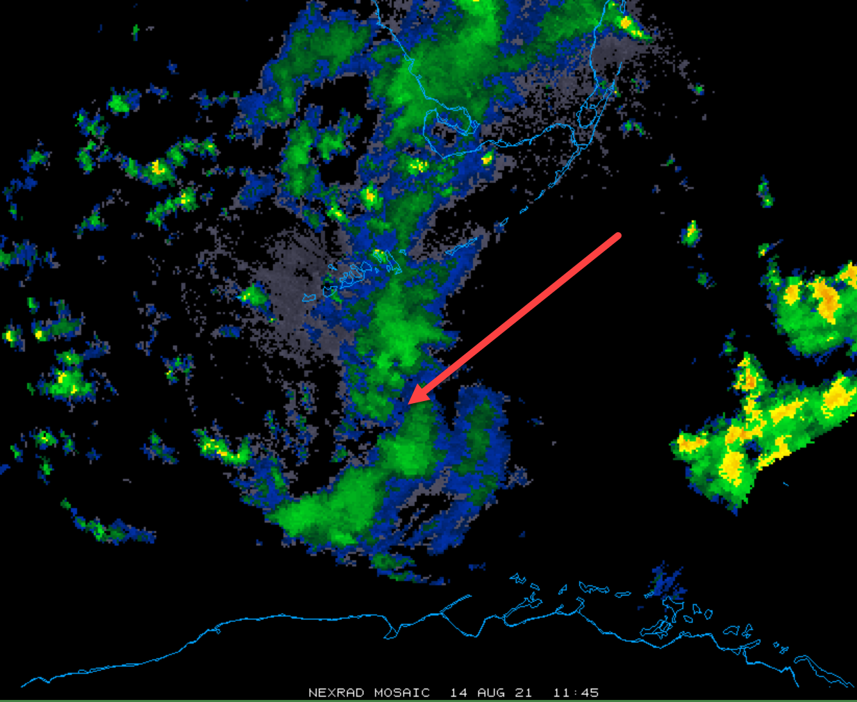
If there is one we might see it on radar. Probably not, but there could be a slightest hint at some circulation. https://weather.cod.edu/satrad/?parms=local-S_Florida-comp_radar-24-1-100-1&checked=map&colorbar=data

-
11:00 pm: WATCHES AND WARNINGS -------------------- CHANGES WITH THIS ADVISORY: The Tropical Storm Warning for the Middle and Upper Florida Keys from the Seven Mile Bridge to Ocean Reef has been discontinued, including Florida Bay. The Tropical Storm Watch along the west coast of Florida has been discontinued. Discussion excerpt: Tropical Depression Fred Discussion Number 18 NWS National Hurricane Center Miami FL AL062021 1100 PM EDT Fri Aug 13 2021 Interaction with land and southwesterly shear has continued to take a toll on Fred this evening. It is very difficult to determine in infrared satellite imagery and recent surface observations from Cuba if a closed circulation still exists, however the system is maintained as a tropical depression for now. Scatterometer data, which should arrive very soon, and reconnaissance aircraft observations on Saturday morning should provide additional information on the system's intensity and structure. The system still appears to be moving moving westward or 280/11 kt. There has been no change to the track forecast reasoning from the previous advisory. The cyclone is approaching the western periphery of a subtropical ridge extending over the western Atlantic, and Fred should turn west-northwestward overnight, and then northwestward on Saturday. The track guidance has again shifted westward, but the shift is not as large as was noted on the previous cycle. The NHC track forecast has been adjusted to the left, closer to the consensus aids, but it still remains to the east of those models. Some additional westward adjustments in subsequent forecasts may be required. As mentioned above, land interaction and southwesterly vertical will limit any attempt of re-organization overnight, however the system is expected to move off the northern coast of Cuba Saturday morning and the global model guidance suggests that a center re-formation could occur over the western portion of the Straits of Florida. The center re-formation shown by the guidance appears to be aided by an area of upper-level diffluent flow to the southeast of an upper-level trough currently located over the eastern Gulf of Mexico. Although only a little strengthening is indicated in the official forecast through 36 hours, the environment could become a little more conducive on Sunday, and the NHC wind speed forecast again calls for gradual strengthening while Fred moves northwestward over the eastern Gulf. The updated intensity forecast is unchanged from the previous advisory and is a blend of the statistical guidance and the HCCA model. The intensity forecast continues to be of lower-than-normal confidence given the current disorganized structure of the system.
-
Every night this week my wife asks me, the resident house met, "Well, what's it going to do?" Tuesday night: "We'll know in the morning. Some say a hurricane, others say it is dead." Wednesday night: "We'll know in the morning. Some say a hurricane, others say it is dead." Last night: "We'll know in the morning. Some say a hurricane, others say it is dead." Tonight: "We'll know in the morning. Some say a hurricane, others say it is dead."
-
I never liked the idea of a "Fred" anyway. A "Freida", sure. But Fred?? "I survived Hurricane Fred." I don't like it. Yabba dabba do? Sorry, it is my age and what I grew up watching.
-
I don't think that is in question, at least for me. No outer bands of Fred here. Maybe it is about the heat, humidity, and other factors over Florida being enhanced by the remains of Fred as it moves more towards Florida. Given what is happening with formula number one (thunderstorms already packing a respectable punch), and formula number two (Fred's whatever will be left and it's tail following along), Florida is in for a few likely scenarios including a TON of hard pounding rain with possible inches at a time and some significant winds where we are already seeing near hurricane strength gusts on a daily basis. A Cat (?) hurricane from Fred, we'll leave that to the turtle maybe, but will we who live here in Florida experience a "Fred"? I do think so. Just timing maybe. If it does become a Tropical Storm which the NOAA still suggests, Fred might have quite an impact. Not only here but in other states as well.
-
The winds and rain we've had here over a few days combined would be what we'd expect from a Tropical Storm. In fact, I've done more cleanup in my yard today than with Hurricane Elsa which passed by just a few miles off the coast of here. Plus several hours of losing power which we only had a few minutes during Elsa, and zero outage with Eta.
-
All that giant convection we've seen trail behind and follow Fred to the east and south for days may possibly follow what's left of Fred into Florida and GA, SC, NC, etc. Maybe it is a day or two behind, or three days even, yet we can see what we see. It has been more exciting and interesting to a lot of us deceiving and tricking us into thinking a new Fred was forming. Even if Fred dies, all that is behind it could be memorable for we who live in Florida. Or everything might fizzle and be a bust...
-
In all seriousness, I haven't seen lightning like the past few days here in a couple years or more. Maybe several years. I love lightning and stay up all night waiting to watch any and have been doing so my entire life. This week there is a "charge" in the ground and it is releasing intensely. Impressive. Does it have anything to with what Fred might do, or might not do. Beats me. But I will say there is something going on meteorologically on this little peninsula, maybe easily explained by mets who know more than me.
-
8 PM NOAA Public Advisory: "Maximum sustained winds are near 35 mph (55 km/h) with higher gusts. Little change in strength is expected <******>. After that, slow strengthening is forecast, and Fred could become a tropical storm again on <*********>." "The estimated minimum central pressure is 1013 mb (29.92 inches)" Have we not seen this repeated for about 72 hours?
-
I'll try to do my part.
-
Take notes.
-
I'd also recommend a live streaming IP cam on battery backup that we can watch live. I set them up as a side gig and can walk you through the process. Here is one I do for a client that during storms has tens of thousands of visitors every passing storm: https://beachresortcondos.com/clearwater-beach-live-webcam.html My front yard cam which is mostly for security (local police visit me regularly asking for clips for whatever reason): http://007computer.com/camera-1.html Few hundred bucks to set up an HD IP cam for the web, and streaming is less than you'd think with as many visitors you would imagine. My weather station cam: http://007computer.com/camera-4.html I have a few in my backyard recording weather and critters, etc. 24/7/365, that are not public, well because we don't always have clothes on. Fortunate to have a very private backyard jungle.
-
This IS banter until it gets serious. Party!! Friday night, not interested in anything else, "Fred is Dead", but Fred is NOT dead yet! Weenies, wish-casters, kooks, nutcases, jump in while you can. It's likely soon the real mets will finish dinner and jump in. Unless they all gave up on Fred. LOL If it does get serious, some moderator create a Banter Thread for we who are obsessing on a weekend of "something" in our yards, whatever it may be.
-
One of my amateur met tools is how our backyard wildlife behavior changes when something is happening. Obviously not a scientific gauge, but for thousands of years humans have watched the critters and follow their lead. Even with earthquakes horses and cattle get restless when we humans are oblivious of what is about to happen. I filled my bird feeders two days ago, ten pounds of seeds. Baby bird season is mostly over, so that lasts a week or so normally. This time of year sometimes with the rain I end up dumping 20% or so as it gets wet and spoils. As of this morning the feeders were 85 to 90% full, as normal. Right now dozens of sparrows, all of our 8 or so bluejays, doves galore, our yard cardinals, and even a flock of local Nandy parrots have wiped out the remaining food in a few hours. Plus cleaning up all the spilled seeds on the ground like they are starving. Hmmm, what do they know? What do they "feel"? If I were the Shaman for a small tribe of family and friends, I'd be telling everyone to stock up on fresh water and food, and secure the tepees or structures.
-
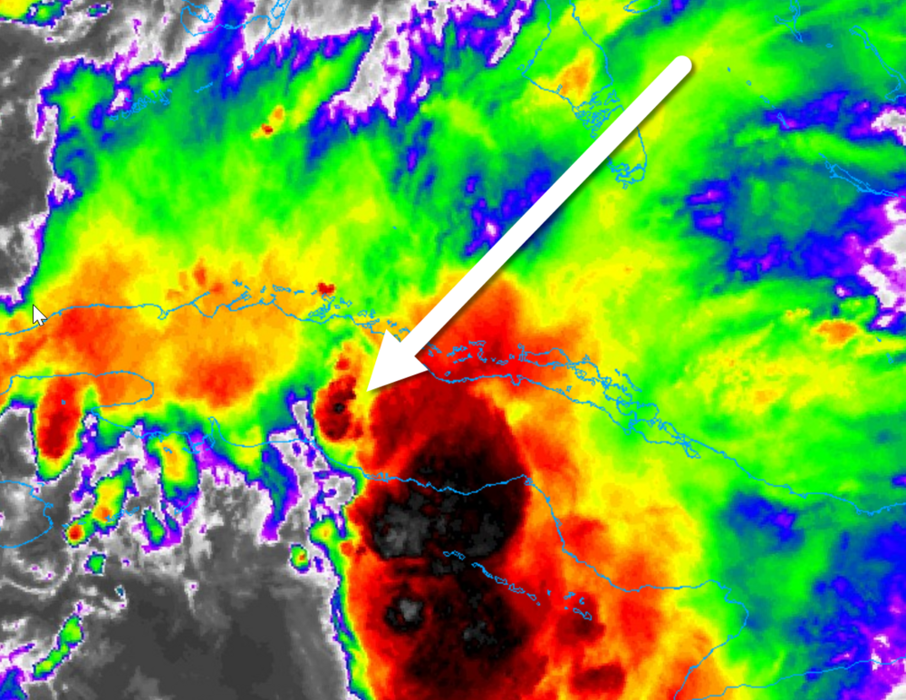
Based on where the NOAA says the LLC is located over Cuba, I'd say it looks better than when over the water. Less shear over land? The heat and energy over Cuba (like Florida right now) pumping it up? I don't know. But if this stays tough and moves back over warm waters it has potential. Right?
-
Even if it is not a full-blown Tropical Storm and is a ways off-shore, its influence will add a big steroid dose to what is already been happening on the west coast of the Florida peninsula. Our "typical" August thunderstorms have blown the last couple years away already. At least what we are seeing where I live; crazy lightning and thunder, wind gusts near hurricane strength, power outages which have been far and few between since Duke Energy rebuild our power grid after Irma, and the raw "feel" of something different. Exciting actually. A weak Fred depression or passing wave might out-perform even a respected Cat 1 that passes by in the Gulf this weekend. I'm not putting up plywood on my windows, but will be securing our projectile rich backyard tomorrow watching the radar to hopefully not be scrambling in the rain to batten down the hatches.
-
It is easy to lose where the center is. This forum has a lot of opinions and of course watching sats we get our own ideas. But when all else fails I refer back to the NOAA. And I look at the cone image where there is an "X" where they say the center is. Sometimes it goes against everything you read here, like last night, or what we think we see, but it is a good solid "back to reality" more often than not. See below, the 5 pm updates: Side note: In my teens we didn't even have the Weather Channel. I can't say we even had radar on the TV news. But next to "Bugs Bunny / Road Runner Hour", the local weather news was my favorite TV event since I was about 5 or 6 years old. "How much snow would we get?" "How much rain?" "Is there a Hurricane coming?" Every day, twice a day; morning and evening, I wanted to be THE weather guy. How exciting! That was my dream. I graduated HS and become a computer techie in 1978. I'm not unhappy with that, but always miss not becoming a met. That was my calling. You are lucky to have so much information and resources at your hands and you already know you could be the next "Jim Cantori" being in the middle of every best storm. (Yea, Jim may not even hold that title anymore...) Good luck, become the best!!
-
The weather in Florida is volatile as all get out. If a seagull flaps a wing it starts a thunderstorm right now. Whatever is left of Fred will create a powerful ripple of weather across the state.
-
Was just looking at the 11:00 discussion. I bolded what I found interesting especially as it has been looking so bad. 326 WTNT41 KNHC 131451 TCDAT1 Tropical Depression Fred Discussion Number 16 NWS National Hurricane Center Miami FL AL062021 1100 AM EDT Fri Aug 13 2021 Fred remains disorganized this morning... Fred is continuing to experience about 20 kt of westerly or southwesterly vertical wind shear, and these conditions should continue for at least another 24 hours. Between that and land interaction, the intensity forecast calls for only modest strengthening during this time. After that, there is still relatively poor agreement on how much shear Fred will experience as it crosses the eastern Gulf of Mexico, with the ECMWF and the UKMET forecasting less shear than the GFS and CMC global models. Due to the uncertainty, the intensity forecast will keep the previous peak intensity of 45 kt. However, the intensity guidance during this period has trended a little higher, and the 45 kt peak is now a little below the upper edge of the guidance. It should be noted that much of the Florida peninsula is expected to be on the east side of Fred, which is where the heaviest rains, strongest winds, and a chance of tornadoes will be.
-
So at 5 am Fred looks a lot better than this time yesterday, but not as good as when I went to bed last night. Still looks like a Tropical Storm, at least, will be in my backyard in two days so starting to prepare. If it stays on track tomorrow is going to be crazy at every store around Tampa Bay.

-
Tropical Storm Warning up for the Keys and Florida Bay at 5 am. 000 WTNT31 KNHC 130843 TCPAT1 BULLETIN Tropical Depression Fred Advisory Number 15 NWS National Hurricane Center Miami FL AL062021 500 AM EDT Fri Aug 13 2021 ...FRED CONTINUES TO PRODUCE HEAVY RAINS ACROSS EASTERN CUBA... ...TROPICAL STORM WARNING ISSUED FOR THE FLORIDA KEYS... SUMMARY OF 500 AM EDT...0900 UTC...INFORMATION ---------------------------------------------- LOCATION...22.0N 76.7W ABOUT 125 MI...200 KM SSW OF GREAT EXUMA ISLAND ABOUT 370 MI...595 KM ESE OF KEY WEST FLORIDA MAXIMUM SUSTAINED WINDS...35 MPH...55 KM/H PRESENT MOVEMENT...WNW OR 300 DEGREES AT 10 MPH...17 KM/H MINIMUM CENTRAL PRESSURE...1013 MB...29.92 INCHES WATCHES AND WARNINGS -------------------- CHANGES WITH THIS ADVISORY: The Tropical Storm Watch for the Florida Keys and Florida Bay has been upgraded to a Tropical Storm Warning. The Tropical Storm Watch has been extended northward from Bonita Beach to Englewood, Florida. SUMMARY OF WATCHES AND WARNINGS IN EFFECT: A Tropical Storm Warning is in effect for... * The Florida Keys west of Ocean Reef to the Dry Tortugas * Florida Bay A Tropical Storm Watch is in effect for... * The Cuban provinces of Ciego de Avila, Camaguey, Las Tunas, Holguin, and Granma * The southwest coast of Florida from Englewood south and east to Ocean Reef A Tropical Storm Warning means that tropical storm conditions are expected somewhere within the warning area within 36 hours. A Tropical Storm Watch means that tropical storm conditions are possible within the watch area. Interests in the Bahamas and elsewhere in Cuba and the Florida Peninsula should monitor the progress of Fred. Additional watches and warnings will likely be required for portions of these areas later today. For storm information specific to your area in the United States, including possible inland watches and warnings, please monitor products issued by your local National Weather Service forecast office. For storm information specific to your area outside of the United States, please monitor products issued by your national meteorological service. DISCUSSION AND OUTLOOK ---------------------- At 500 AM EDT (0900 UTC), the center of Tropical Depression Fred was located near latitude 22.0 North, longitude 76.7 West. The depression is moving toward the west-northwest near 10 mph (17 km/h) and this general motion is expected to continue today. A turn toward the northwest is expected tonight or Saturday. On the forecast track, Fred is expected to move along or just north of eastern and central Cuba through tonight, be near the Florida Keys on Saturday, and near the west coast of Florida on Sunday. Maximum sustained winds are near 35 mph (55 km/h) with higher gusts. Slow strengthening is expected during the next couple of days, and Fred could become a tropical storm again later today. The estimated minimum central pressure is 1013 mb (29.92 inches).
-
Storm Banter threads are a good place for many of us who come here for entertainment, but from what I've seen they only come up when something gets serious. We all come for what the mets say, of course. With this site having almost 17,000 members, like it or not, these threads are fun for we who are weather nerds looking for a place to hang out. I know I post too much, but try to add graphics or occasional attempts at serious opinions, etc. But personally enjoy other people's thoughts who are on the same level as myself. Maybe Banter should come up before a storm is a dangerous threat so we who just have fun sharing "banter" are free to entertain ourselves. It is a balance hard for people like me who sometimes (always) get excited about any little weather thing. But then we must ask, what is "normal" anyway. I'm a web developer, wonder if the world needs a Weather Forum for non-mets...
-
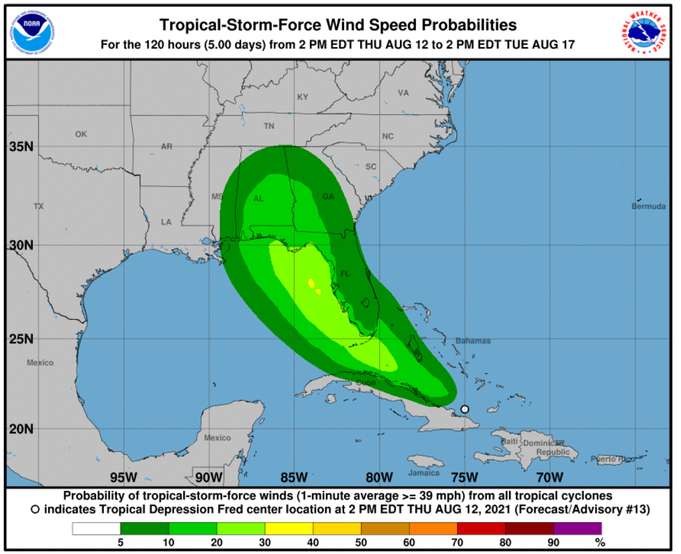
If nothing else, the "cones" over the past couple years have been very good. Below does say a lot:

-
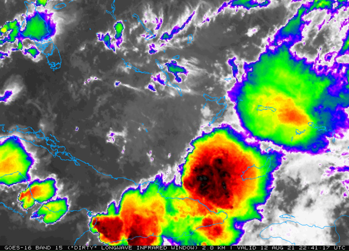
Helluva spinning convection east of the LLC. So it appears there is energy, just not aligned right now. Tonight will be interesting.