Prospero
-
Posts
1,162 -
Joined
-
Last visited
Content Type
Profiles
Blogs
Forums
American Weather
Media Demo
Store
Gallery
Everything posted by Prospero
-
 I was there, little green bottles going around. Great Sugaree! (I have a CD from a .flac download.) Saw them in Philly the night after the earthquake and we didn't know if they'd make, but they did. Opened with Shakedown Street.
 -
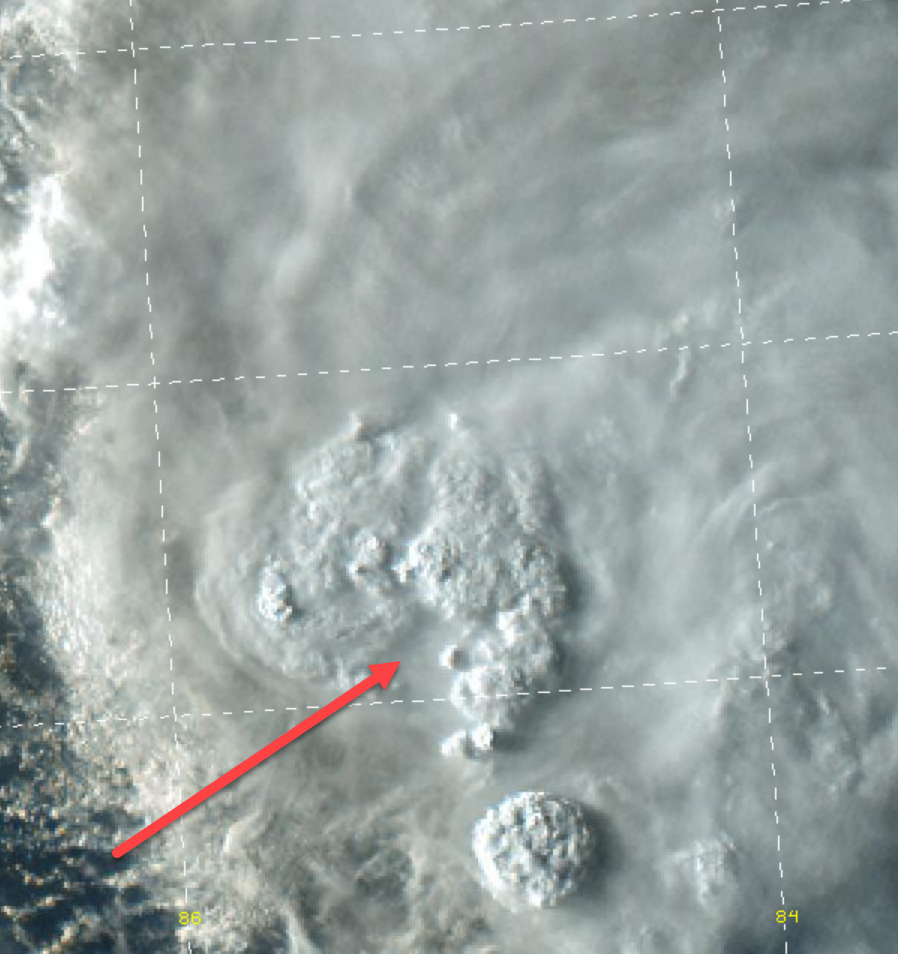
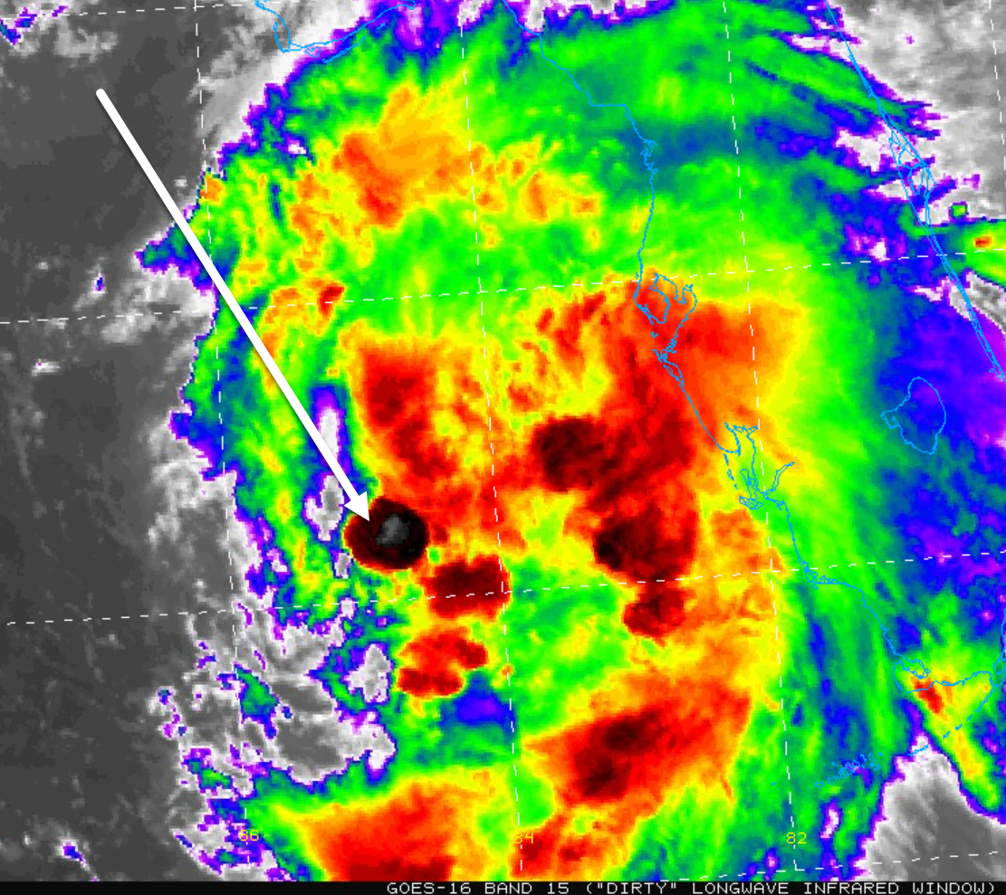
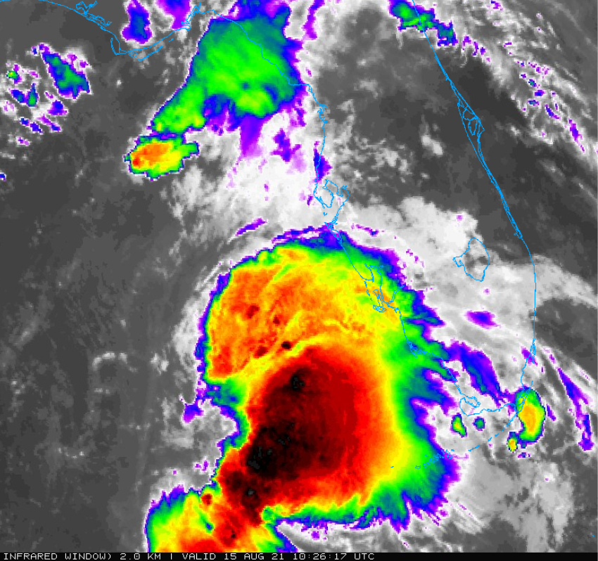
Coordinates: 27.1N 85.7W Interesting, that is kind of in the middle of the convection:

-
Yea, not the wildest storm I've been near. But all I have for a Sunday afternoon that I have been planning on for a week or so. All in all, I'm satisfied for what we have seen around Tampa Bay. Fun enough for me. We might get more tonight, but it will not be costly or painful. There is a band coming in that I'll stay up for. Plus it is very hard to complain about any day in August around here when the temperatures stay in the low 80's and upper 70's with a breeze.
-
I was about to claim I saw an eye to see if anybody was awake. LOL
-
A topic that has come up this season has been the storm activity in EPAC and how it affects the Atlantic storms. I'm sure it was not that long ago in meteorological history when that concept would be laughed out of the room. Good grief, it was like yesterday that people thought the sun went around the Earth which was flat. I remember a legend where the Grateful Dead were playing "Fire on the Mountain" when Mt. St. Helen's blew up. And everybody who knows the Grateful Dead knows that Phil's bass beat will shake up the Earth.
-
Another burst of convection over the LLC. Funny, Fred has lost interest of almost everybody around here. The forum will pick up later I guess. The band we had earlier may be the worst we get here in Tampa Bay. At least it was in the daytime and I was up to watch it!
-
On a scientific level that is a very complicated question. How close was the trigger that set off the earthquake? Was some extra weight and imbalance on the surface enough to do it? How deep does the Earth feel air pressure changes? Does the ground breath and expand with the air? If so, how deep does it go? Does the moon and tide have an impact on the Earth's crust as well? Did the moon's gravity tug at some molten mantle? Did me dropping a paver block in my backyard the other day create a ripple that vibrated to Haiti? I tend to believe that everything is connected to everything else on some level. Anything that happens anywhere is related to everything that happens everywhere else. Just the way I think...
-
59 mph gust at Albert Whitted Airport here in St Pete just now.
-
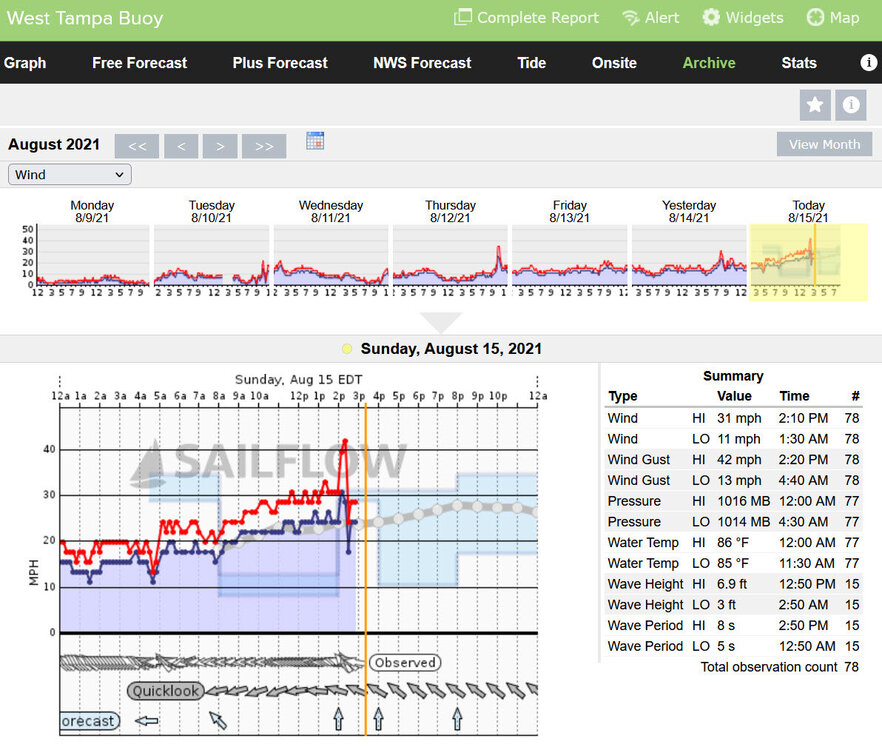
42 mph gust at the Pensacola Buoy and the West Tampa Buoy within the last few minutes. 34 mph at the Skyway Fishing Pier on Tampa Bay. Having out first driving rain from some storms that came from inland. Looks like we are on the edge of a TS! Convection hanging onto the LLC so far. Time to switch from coffee to beer!
-
The convection is blowing up likely due to the temperature of the Gulf and the LLC underneath is towards the southwestern part of the burst. But if it stacks up and doesn't blow off we'll have something more interesting to watch for a while. Still seems to be tracking north, at least the past couple hours.
-
First time I remember seeing a convection burst directly over the LLC of Fred.

-
Looks to me like the LLC is moving almost due north on sats.
-
Under a warning now. A Storm Surge Warning has been issued for the coast of the Florida Panhandle from Indian Pass to Steinhatchee River. A Tropical Storm Warning is now in effect for the coast of the Florida Panhandle from Navarre to the Wakulla/Jefferson County line.
-
That's a landfall at about Panama City Beach, or right on Mexico Beach. UGH
-
May I ask, what is a "non-linear" increase"? Conditions in Gulfport, FL: Light rain here with a steady 15-20 mph breeze. Looks like we'll have that for now on and both will increase some as the day goes on. There was a 32 mpg gust at Surfside Condos on Clearwater Beach a few minutes ago.
-
@SandySurvivor Did you get chasing in? How did it go? Any pix or video clips? I guess Key West would have been the best location.
-
11:00 am discussion: The center re-formed northward during the redevelopment process, and the initial position is re-located to the north of the previous advisory position. While the forecast guidance is basically unchanged in calling for a north-northwest motion followed by a turn toward the north near landfall on the northern Gulf coast, the new initial position requires the forecast track to be shifted about 40 n mi to the east of the previous track through the landfall time. Fred is now expected to make landfall in the western Florida Panhandle sometime Monday afternoon or evening.
-
Elsa and Fred, sitting in a tree...
-
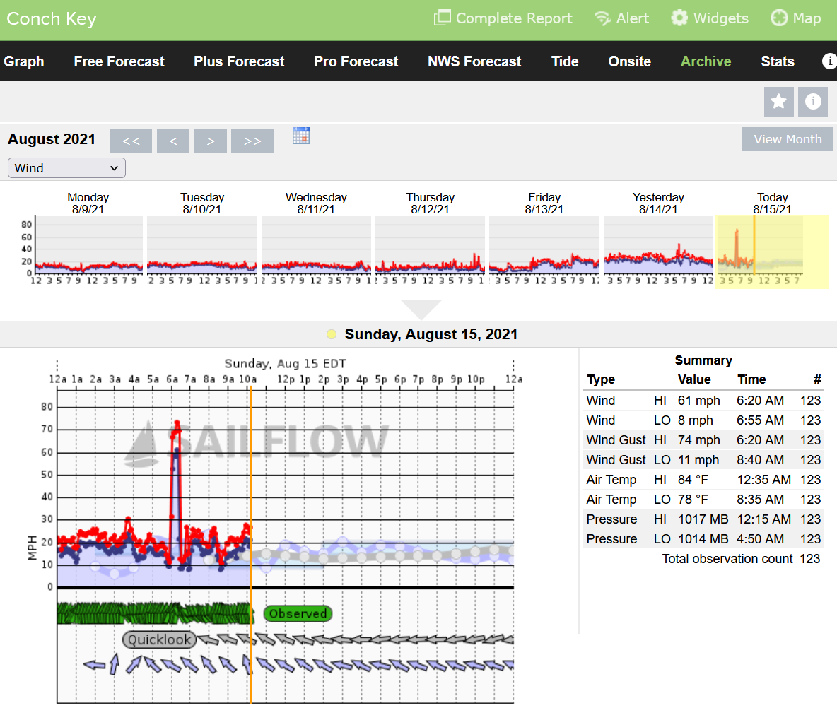
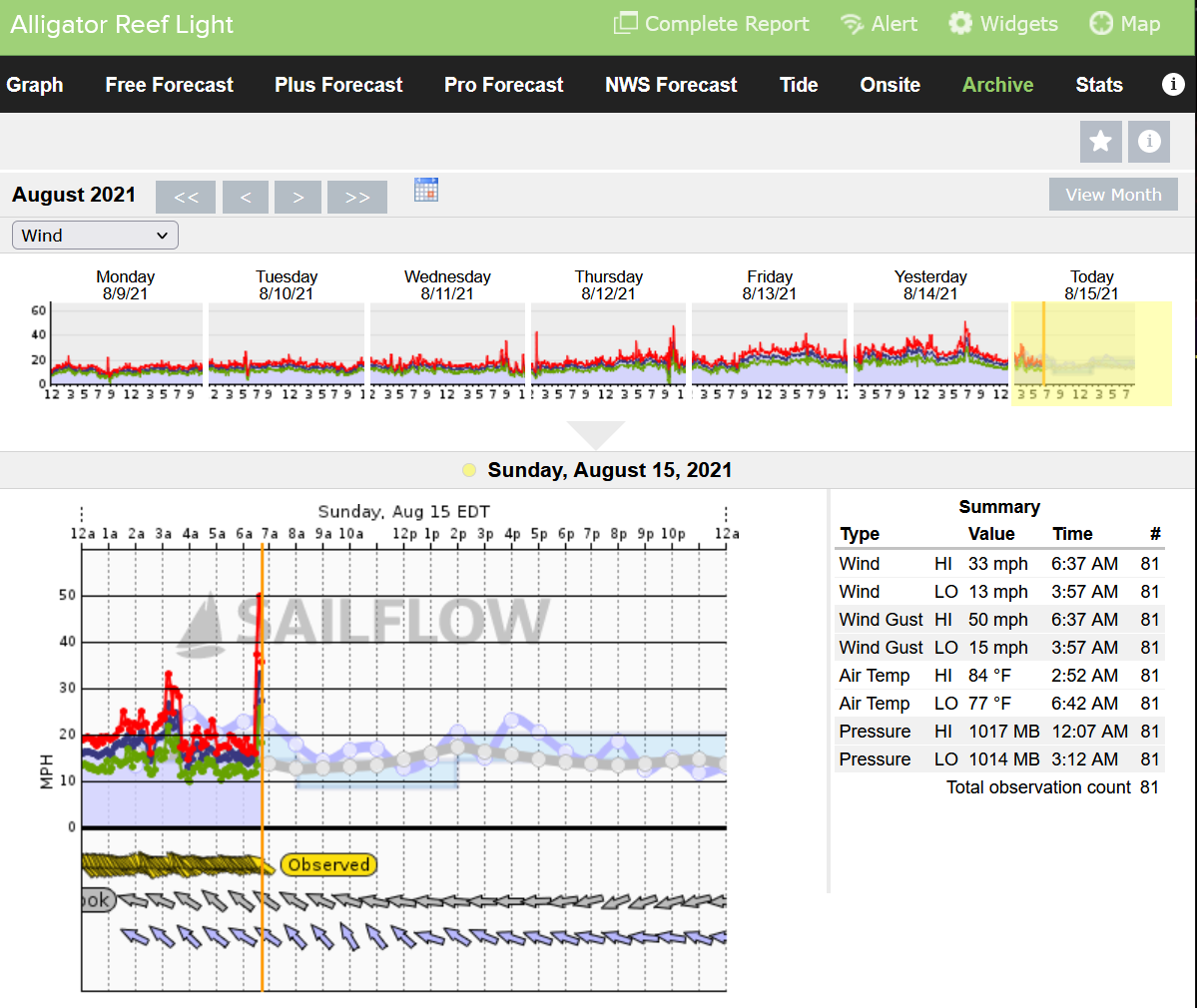
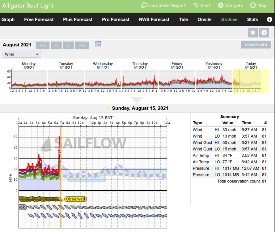
SailFlow is where I look. There was a 50 mph gust at Alligator Reef Lighthouse a few miles from there around 15 minutes later that I posted earlier. I'm sure it was a line of thunderstorms that passed over the eastern keys in an outer band. I would suspect a waterspout made this spike, but it appears the 60 mph winds lasted about 15 minutes or so which is more in line with a severe thunderstorm.
-
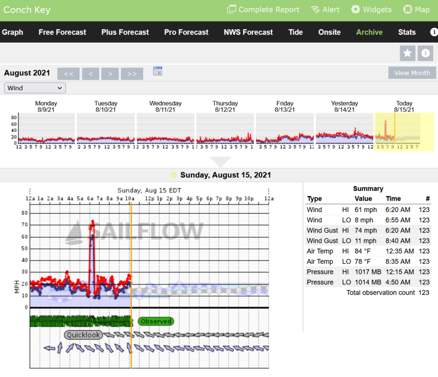
I just noticed this wind gust of 74 mph at 6:20 this morning at Conch Key. As far as I know this is the highest recorded wind so far in the US from Fred. But I have not looked much yet. If we get only one gust like that in Gulfport, FL we'll still have some issues...
-
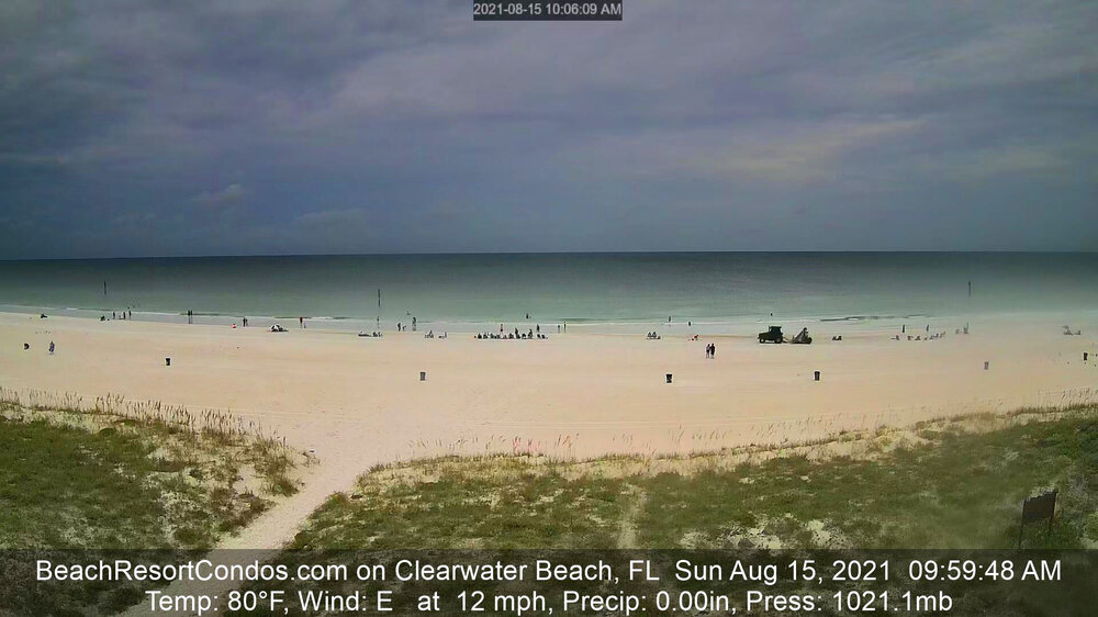
We just ran out to St Pete Beach to get an omelette at the best breakfast place in Pinellas County, "The Frog Pond," just in case Fred does some kind of wild RI and makes a hard unexpected right turn towards the coast like Charlie did at the last moment and destroys all our favorite beach places as a Cat 3. You know, "just in case." The weather is very nice right now, cool and cloudy with a nice steady off-shore breeze. The sky is very dark over the Gulf. Image below from Clearwater Beach.
-
50 mph gust at Alligator Reef Lighthouse which is pretty far east of Fred right now. So as it regains its TS status we'll see more of these pop up.
-
Fred looks better this morning. Yesterday was a relatively cool quiet cloudy day around weather wise. This morning we can feel a decent breeze from Fred and there is that "feel" of a Tropical system. If I were a little kid I would say we feel the "big air" moving. I don't have any plans to secure anything except move a few potted plants to the ground and put away anything that can fly around with bigger breezes. It does look like we could be scraped by the edge of some bands later with rain and some wind, although probably not TS strength. That is still fun enough for me. Looks like the cone inched back east a little bit overnight.

-
040 WTNT41 KNHC 142039 TCDAT1 Remnants Of Fred Discussion Number 21 NWS National Hurricane Center Miami FL AL062021 500 PM EDT Sat Aug 14 2021 Satellite imagery this afternoon shows that a broad and elongated circulation has formed in association with the remnants of Fred, and that the convection has become more concentrated at the east end of the elongated center. However, neither the circulation nor the convection are organized enough to justify calling the system a tropical cyclone at this time. An Air Force Reserve Hurricane Hunter aircraft is scheduled to survey the remnants of Fred this evening to see how far the re-development has progressed. The initial motion is a still very uncertain 300/11. The system is expected to move northwestward around the western periphery of the subtropical ridge, with a turn toward the north expected as the system nears and moves inland along the northern Gulf coast in 48-60 h. The forecast guidance remains in good agreement on this general scenario and the new NHC forecast track is close the the consensus models. However, some adjustments to the track forecast could occur depending on where the center of Fred re-forms. Therefore, users should not concentrate on the details of the forecast track, which could change quite a bit during the next day or so. The global models are now in better agreement that the upper-level trough over the eastern Gulf of Mexico that has been hindering the development of Fred will move northward and weaken during the next 24 h. They also indicate that Fred is likely to re-form a well-defined closed circulation over the eastern Gulf of Mexico Sunday morning. Thus, the intensity forecast now calls for Fred to regain tropical cyclone status in about 12 h, followed by gradual strengthening until landfall in a less than ideal upper-level wind environment. After landfall, the system should weaken and dissipate between 96-120 h. The new NHC intensity forecast follows the overall trend of the intensity guidance. Although no coastal watches or warnings are currently in effect, the National Hurricane Center will continue 6-hourly advisories on the remnants of Fred in anticipation of re-development. Watches could be required for portions of the northern Gulf coast tonight, and warnings may be required on Sunday. KEY MESSAGES: 1. Today through Monday, heavy rainfall could lead to areal, urban, and small stream flooding impacts, and cause new and renewed river flooding across southern Florida, the Big Bend, and Panhandle. From Monday onward, heavy rain and flood impacts could extend into other portions of the Southeast and into the southern and central Appalachians and Piedmont as Fred interacts with a front in the area. 2. Fred is forecast to regenerate as a tropical cyclone over the Gulf of Mexico tonight or on Sunday, and bring a risk of tropical storm conditions to portions of the northern Gulf coast, especially from coastal Mississippi to the Florida Panhandle beginning on Monday. Watches may be required for a portion of this area tonight, and warnings may be required on Sunday. FORECAST POSITIONS AND MAX WINDS INIT 14/2100Z 24.0N 84.6W 30 KT 35 MPH...DISTURBANCE 12H 15/0600Z 25.0N 85.7W 30 KT 35 MPH...TROPICAL CYCLONE 24H 15/1800Z 26.6N 87.1W 35 KT 40 MPH 36H 16/0600Z 28.0N 87.9W 40 KT 45 MPH 48H 16/1800Z 29.4N 88.2W 45 KT 50 MPH 60H 17/0600Z 30.9N 88.3W 35 KT 40 MPH...INLAND 72H 17/1800Z 32.4N 88.2W 25 KT 30 MPH...INLAND 96H 18/1800Z 36.0N 87.5W 20 KT 25 MPH...POST-TROP/INLAND 120H 19/1800Z...DISSIPATED $$ Forecaster Beven
-
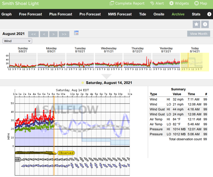
Smith Shoal Lighthouse is approaching TS conditions. The pressure is slightly lower than what NOAA has for Fred at 1012MB.