mdhokie
-
Posts
1,627 -
Joined
-
Last visited
Content Type
Profiles
Blogs
Forums
American Weather
Media Demo
Store
Gallery
Everything posted by mdhokie
-
Its been nuts the last couple weeks out in western MD.. I've gotten a lot of outdoor work done, don't even need a coat!
-
Wheres the cold air??
-
2024 Valentines Day Who the Hell Knows - Comeback Thread
mdhokie replied to DDweatherman's topic in Mid Atlantic
NWS more concerned with flooding around the metro areas... 30-50% chance of an inch up by the PA line! Text Products for AFD Issued by LWX (weather.gov) Synoptically, we continue to monitor a strong 500 mb upper level low pressure system that will eject out of the southern Plains early Monday and into the Ohio/Tennessee River Valleys Monday afternoon into Monday evening. Meanwhile, at the surface will watch the progression of a cold front dropping south from Canada and New England into the Mid-Atlantic Monday afternoon into Monday night.The progression of this front south combined with the placement of high pressure over central and eastern Canada will dictate how much cold air makes it into the region especially as the upper level low slides up the Mid-Atlantic coast late Monday night into Tuesday afternoon. Current deterministic and ensemble guidance continues to show subtle differences in regards to the timing and intensity of the upper level low as well as the progression of the front. The 12z NAM remains the coldest solution while the GFS, GEM, GEFS, ICON, and ECMWF have trended warmer over a large chunk of the forecast region. This is particularly true in regards to the H85 0 degree isotherm ballparked up around the PA Turnpike and I-80 region amongst most of the guidance. Even with that said, several model solutions still have the 0 degree C isotherm line in the vicinity of the PA/MD border during the early Tuesday morning into Tuesday afternoon timeframe as the upper level low/trough axis strengthens and swings overhead. This will allow for a period of dynamical cooling for precipitation to change from rain to snow. Once again this will be determined by the surface low pressure system track and transfer of upper level energy from the central Appalachians toward the Mid-Atlantic coast. Plenty of uncertainty remains here and still has yet to be ironed out amongst the models. As of now, the highest confidence for impactful winter weather remains in climo areas along and west of the Allegheny Front Monday night into Tuesday. Areas further east of the mountains (especially the Catoctin Mountains and areas along the immediate PA/MD border) may see a brief period of rain changing to snow due to dynamical cooling from the trough axis swinging overhead Tuesday morning into Tuesday afternoon. Ensemble/NBM probabilities continue to show probabilities of 2 to 4 inches of snow hovering between 30-50 percent for areas along and west of the Allegheny Front with 30-50 percent probabilities of 1 inch of snow along the PA/MD border including the Catoctin Mountains. Higher snow amounts greater than 4 inches can be found across central PA and northern NJ where deterministic/ensemble guidance continues to illustrate the best frontogenetic forcing setting up. Any changes in the track of the system (further south), strength, and timing of the H85 cold front could play big dividends in where the best forcing/highest impact from wintry weather sets up. For now, the current forecast favors snow over the mountains of the Allegheny Front/Catoctins and rain elsewhere across the region. More on snow totals at weather.gov/lwx/winter. Outside of the wintry threat the bigger concern may be flooding given saturated soils, elevated streamflows, and heavy rainfall within a short period of time (6-9 hour window). Rainfall amounts will remain between a 0.5 to 1.50 inches with this system with locally heavier amounts along and east of I-95. High temperatures for most Monday will push into the mid to upper 40s with increasing easterly flow. Lows Monday night will fall into the 20s over the mountains with low to mid 30s across the rest of region. Low pressure quickly intensifies and pulls away from the region Tuesday afternoon and evening. This will lead to falling temperatures as gusty northwest flow ushers in cold Canadian air. Highs will will push into the upper 30s and low to mid 40s outside of the mountains. Conditions will dry out east of the mountains with low level moisture allowing upslope snow showers to continue along and west of the Allegheny Front. These snow showers will diminish Tuesday night into Wednesday as brief Canadian high pressure settles in. Another shortwave and clipper-type low pressure system will quickly follow within northwest flow Thursday into Friday. This system will produce another shot of accumulating snow over the mountains with the potential for a rain and snow mix further east. It will also deliver another shot of cold Canadian air to the region. Temperatures will remain 5 to 10 degrees below average by the middle and latter half of next week. -
57 in Deep Creek, two weeks ago it was 60. I guess its good if you want to go hiking. We got some skiing in last night and this morning before it turned to slush. Wisp is barely hanging on in some spots, hopefully we get some cooler weather next week.
-
Current drought conditions - agriculture.canada.ca Western and Central Canada still look dry. At least Eastern looks good. I forget where most of the fires happened last year.
-
Hey it was a great weekend of spring skiing out at Wisp! 50 degrees, blue skies and no lines!
-
My "negativity" is based in reality. The past two weeks have been above normal, and the upcoming week continues that stretch. I'm not rooting for warmth. I love snow. I love skiing. Can't do one without the other. Like I said, go back and re-read the previous LR thread. I'm not knocking on the posters. They provide great insight from the data available. That said, I think we need to step back and look at all of the data available and review what actually happened vs what guidance was showing. I'm hoping we turn around and get a good back loaded winter, otherwise I'll be driving farther to do my skiing!
-
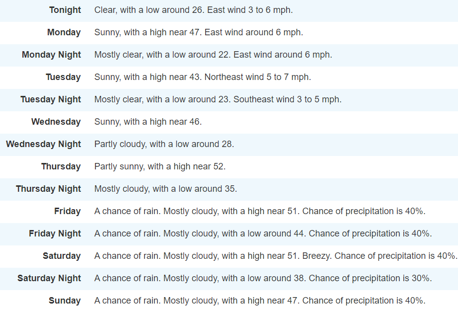
Uh, go back and read the previous long range thread. It gets harder the farther you go back because people delete old images, but there was hype around the Feb 5/6 period, then there was hype around the Feb 14 period. Now its hype around the Feb 20 period. All I know is the warm up period has been longer than anticipated. Local ski resorts have had one or two short night time snowmaking opportunities in the last two weeks. Its supposedly middle of winter! Look at the 7 day forecast for Western MD! Depressing. Those lows are deceiving too, it takes forever to cool down and theres a short amount of time early in the AM where its actually cold enough to make snow before the sun comes. I don't need wall to wall winter but 3 weeks of spring in the middle of our best climo sucks.
-
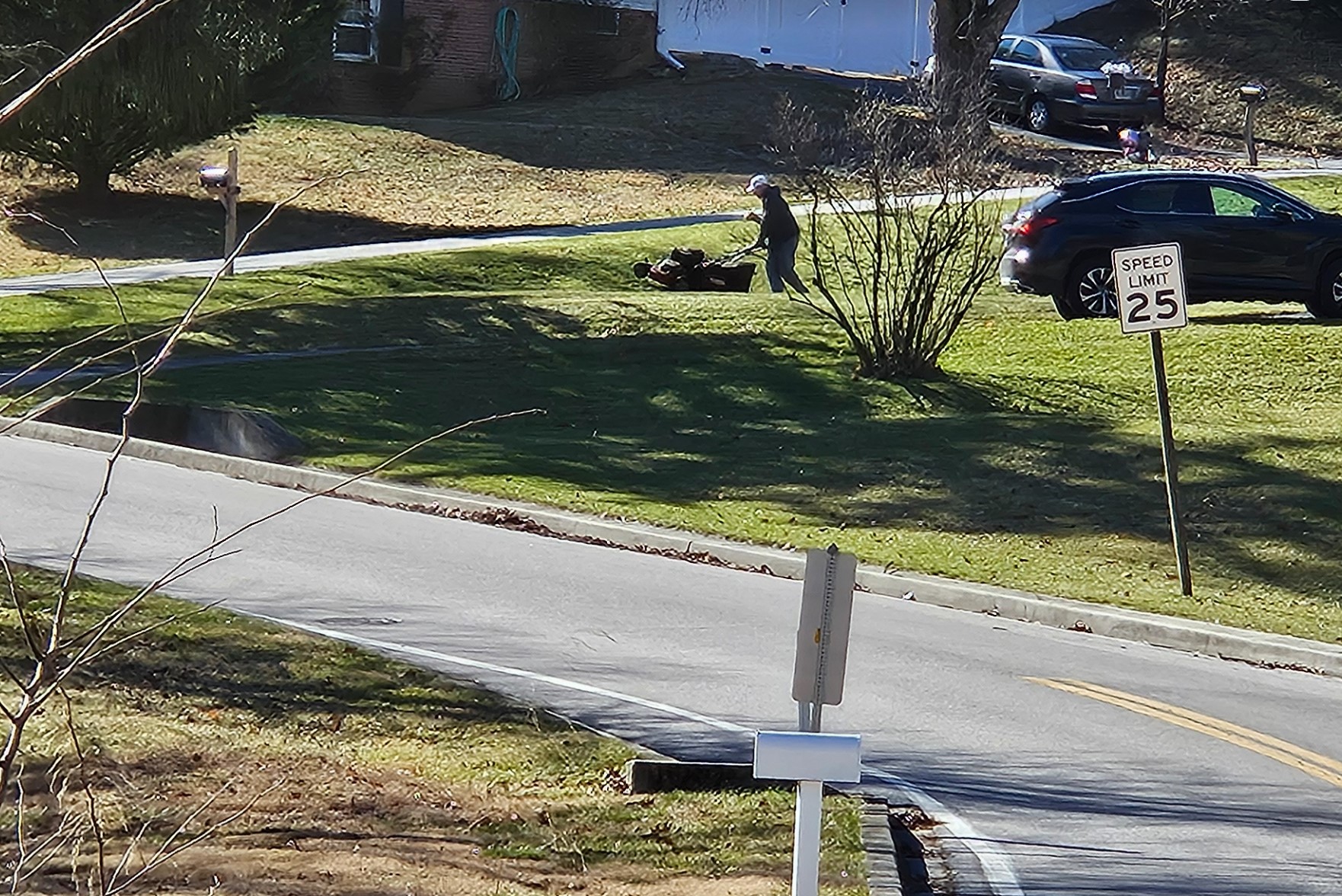
Ok which one of you weenies lives in my hood? Saw this dude prepping his grass for our upcoming BECS period.

- 550 replies
-
- 10
-

-
People initially talked about a "quick" warm up before pattern changing back to ideal. So far we are in week two of warm and looking at least part of next week as well. Sure its not torchy, but its above normal, which sucks for people like me who like to ski. Even out at Wisp, 3000', 66" of natural snow this season, we are looking at muddy bare ground. Thank goodness they were able to make a ton of snow during the 10ish days that felt like winter, but they haven't been able to make snow for two weeks. Mashed potato snow is a good leg workout, but I'm used to seeing it at the end of March, not end of January.
-
If you watch the youtube video i posted earlier, it shows that on almost every play there was a shallow option, and when there wasn't, there was room for Lamar to run for at least 4-5yds. Either by design or by Lamar pressing for the big play, it seems his primary read was always a deep pass. On many plays he didn't have time to progress through to find the short dump off. I would have thought after half time they would have adjusted and focused on the short stuff until KC adjusted, but nope, it was more of the same. Another thing that video shows is dumb use of OBJ. They sent him on go routes multiple times, but he just doesn't have the sustained speed anymore. Completely covered. When used correctly (precise routes, comebacks, crossing etc), he was open and made a couple catches.
-
Not sure if you have the stomach for it but this dude breaks down all of the Ravens offensive plays. Shows that we should have scored a lot more points than we did. KC was giving us stuff underneath all day. Thats not to say #15 wouldn't have found a way to score more points.
-
What was this thread about??
-
Where is the cold air??
-
Not gonna blame this one on the refs but NFL officiating is terrible for a sport that rakes in billions. Ravens got called for a defensive holding early in the game, which was a correct call but very minor hold. Later in the game there were multiple times ravens receivers were held and no call. I understand that they are told to "let them play" in the playoffs, but the uneven-ness of the calls is irritating.
-
Someone has to answer for that... We had no momentum in the first half. Playing from behind in the second. Chiefs basically took our game plan of long punishing drives and used it against us. Monken never got Lamar in a rhythm. Nothing short, no slants, no screens. Honestly flashbacks to cam cameron airing it out on every play. No idea if this was by design or if Lamar was trying too much for the big splash play. Lamar held the ball WAY too long. Either throw it away, check down, or run with it. Trying to hard to prove his passing skills. Monken/Lamar own this loss. I hope Flowers can shake this off. Made a couple rookie mistakes at the wrong time. Penalties / bad decisions cost us at least 6 points. Chiefs are a beatable team but you can't play dumb. Too many turnovers and penalties mixed with a suspect offensive game plan lost the game. Defense played as good as you can against #15. They were on the field for most of the first half and held the chiefs scoreless in the 2nd.
-
I guess it wasn't a torch, but this past week destroyed the snowpack even in western MD. I went from playing in 18" of snow last weekend to bare wet muddy ground this weekend. Wisp really took a beating, looks like snowmaking opportunities later this week. They made snow for a week straight and are back to ~50% open.
-
I thought the piles stood a chance, boy was I wrong! Even the pig plow piles are fading fast in the sun and heat.
-
Where you at?? I'm down by 103/100 and it was pretty heavy 8-12pm. Probably have 5" total. Last hour or so its been very light, fine snow.
-
deer probably fertilized right there.
-
Thats part of the Christmas decorations, smarta$$. Actually it was a covid purchase... Really classes up the neighborhood.
-
They issued a HRW (heavy rain warning) for g-town.
-
Glad I kept the lights up!
-
Me too! Turned them back on tonight. All the neighbors probably think i'm crazy.
-
Jan 15-16 Storm Threat Thread: The Return of Hope??
mdhokie replied to stormtracker's topic in Mid Atlantic
Ahem.. Your snow forecast map kinda had an Atari vibe to it