NorthHillsWx
-
Posts
5,367 -
Joined
-
Last visited
Content Type
Profiles
Blogs
Forums
American Weather
Media Demo
Store
Gallery
Everything posted by NorthHillsWx
-
Currently 65 degrees with Light Rain. Actually have over-performed here as we're sitting at .50" already with rain continuing. Heavy mist has actually been fairly efficient in accumulating. Saw the airport has less than half as much. Had some moderate rain for about 2 hours with a patch that developed right over here. I'll take it. Maybe we can crack an inch between today and tomorrow. Good soaking rain, again
-
These days a "cold" front just means a day or 2 of temps near normal, followed by another surge of +10-15 degree heat
-

Mid to Long Term Discussion 2019
NorthHillsWx replied to Upstate Tiger's topic in Southeastern States
Looks "spooky" dry from Triangle east through the end of all model runs. Quite the difference from the western half of the Carolinas to the eastern side in terms of modeled precip -
Picked up a whopping 0.10 yesterday. Also saw a high of 86 which was absolutely brutal since it occurred AFTER the rain and turned what little had fallen into brutal humidity. Sheesh I thought that was done with! Looking drier and drier for this upcoming system as best dynamics/lift look to stay west of here. Hoping the relief we had on the developing drought was not temporary,,,
-
Mid to Long Term Discussion 2019
NorthHillsWx replied to Upstate Tiger's topic in Southeastern States
I think we may have a chance at our first freeze Monday morning. Given a favorable HP placement, light winds, and low DP this is a VERY favorable setup for maximum radiational cooling. Most models over-do nighttime temps at this range in these setups as well. This wouldn't be much behind our long terms average first freeze, either. Would be interesting to get a freeze before a frost if that came to fruition!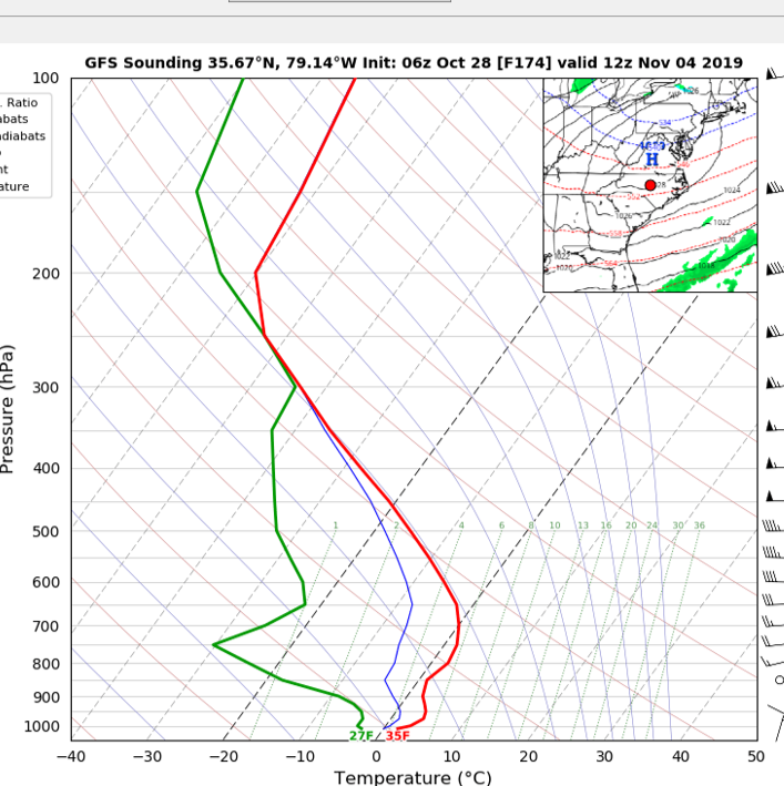
-
2019 Atlantic Hurricane Season
NorthHillsWx replied to AfewUniversesBelowNormal's topic in Tropical Headquarters
Same time haha -
2019 Atlantic Hurricane Season
NorthHillsWx replied to AfewUniversesBelowNormal's topic in Tropical Headquarters
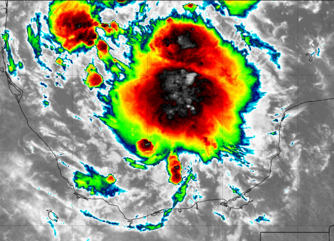
Invest 97L looking healthy this morning. Would not be surprised to see this thing be a quick-developing TS today given the organization this morning. Hostile environment ahead but definitely showing some spin on IR and first visible shots this morning
-
Mid to Long Term Discussion 2019
NorthHillsWx replied to Upstate Tiger's topic in Southeastern States
Wow, the storm this weekend has really trended west, towards the Euro solution, on the GFS from earlier runs this week. What looked like a washout may end up no rain at all in central NC. It does however stall out the boundary and re-form precipitation over the area early next week. Definitely trending towards an amped low in the MS valley for the system this weekend though -
Picked up a quick 0.20" of rain yesterday afternoon. That makes over 3" for the past 2 weeks, or considerably better than it has been
-
Looks like a very brief window for any rain today. Still mostly cloudy and 73 degrees. Gusty wind has developed in the last hour as well
-
Remarkably hot. Glad to get this out of the way before the potential snow months
-
Saw this exact scenario on the 3k Nam for tomorrow, discrete cells then an organized line. First potential severe threat in a while.
-
1.80" at my house in Raleigh. I was at a hunting camp near Havelock for the weekend and we definitely had near-TS conditions. Wind much stronger than I thought it'd be inland, I'm guessing 40-45 mph range when that heavy stuff was coming through. Heavy rain too but short duration. No way to measure but probably a quick 1.5-2." Incredible how I went to bed and the temp was in the upper 50's and woke up to lower to mid 70's with the strong southeast wind.
-
Amazingly hit a low of 38 last night. Coldest night of the fall so far (previous low was 42). No frost yet but that wasn't far from it
-
0.50" yesterday, more than I was expecting for sure. Low of 44 this morning. Currently just south of 60 and absolutely gorgeous outside! Wind has kicked up some last hour
-
Despite the less than impressive appearance on radar reflectivity, this round of showers is producing very heavy rain rates in the Garner area. Just drove to lunch and it was borderline downpour status with heavy ponding of water on the roads and some cars slowing down with flashers on. Definitely more rain than I thought leaving the house this morning. Looks like a good soaking rain too as the light rain this morning saturated the ground. Looks like planting grass Sunday morning in the yard was the right call!
-
Mid to Long Term Discussion 2019
NorthHillsWx replied to Upstate Tiger's topic in Southeastern States
Looking at overnight and morning modeling, the potential system in the gulf, regardless of development, looks like it could bring a widespread beneficial rain to the area. Outside of a few areas east of the Triangle, this has been an underwhelming tropical rainfall season, obviously, and these systems are the ones we rely on during the dry summer months so if we can get this thing in the region I suspect some areas can make a good dent in recent rainfall deficits -
2019 Atlantic Hurricane Season
NorthHillsWx replied to AfewUniversesBelowNormal's topic in Tropical Headquarters
Certainly a lot of shear but a lot of models are latching onto a weak system developing. This would seem to max out as one of the classic gulf half-cyclones maybe attaining low end TS winds. Good news with this system is it has its moisture aimed at the SE, a region that has dealt with significant drought issues over the summer. Recent rains along with the potential for some tropical rain would do a lot of favors for these areas. -
0.08" at my house before I left for work this morning. I think 0.25" may be the max for my area looking downstream we appear to stay in the dry slot today, unfortunately. Still beneficial given the recent dryness.
-
0.48" IMBY. Good, steady soaking rain. Saw some lightning as well. Looks like the Wednesday system has a dry slot modeled for Central NC so this may be our largest rainfall for awhile. Greatly needed
-
Mid to Long Term Discussion 2019
NorthHillsWx replied to Upstate Tiger's topic in Southeastern States
Haha if this was a winter storm this map would be right where you'd want it the triad! -
Mid to Long Term Discussion 2019
NorthHillsWx replied to Upstate Tiger's topic in Southeastern States
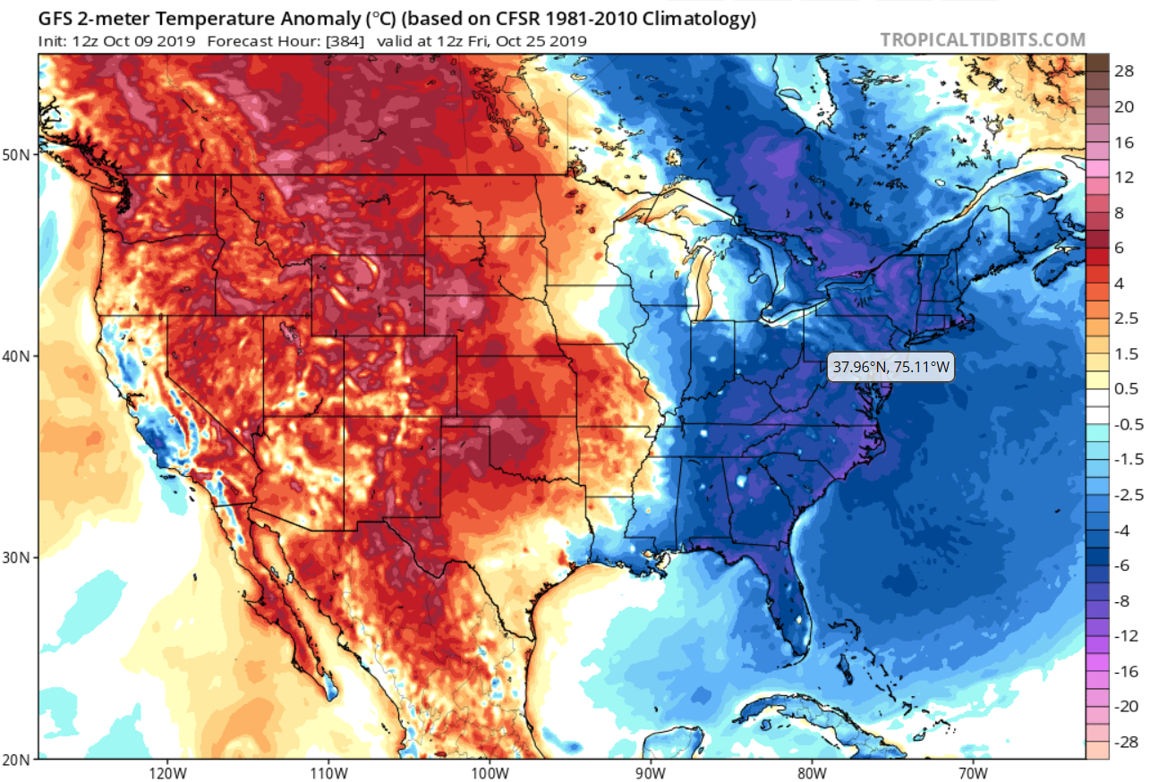
Still no drought relief on the 12z GFS but man is that a stout trough digging in at the end of the run! Would be our first chance at frost in some areas if taken verbatim...
-
Mid to Long Term Discussion 2019
NorthHillsWx replied to Upstate Tiger's topic in Southeastern States
Like a broken record, SE ridging keeps the storm track above us with coastal development too far offshore to get significant rain into the lee of the Apps. This has the markings of a significant drought for much of the Southeast. The areas of severe drought have continued to expand. With no significant change in sight, I would look for that to continue.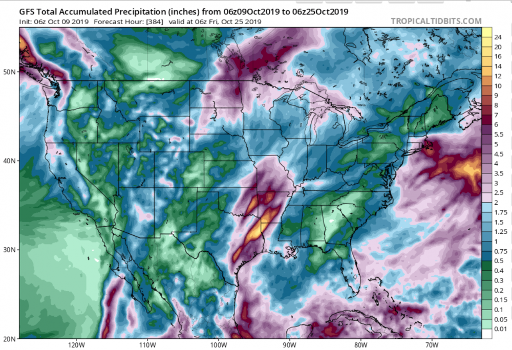
-
Picked up the first measurable rain since Dorian overnight and yesterday afternoon from the heavy mist that occurred all afternoon. A drought-busting 0.01" lol. In all seriousness it was nice to have some of the dust knocked off the truck, but wow it has been dry.
-
Only records we can break these days