

NorthHillsWx
-
Posts
5,367 -
Joined
-
Last visited
Content Type
Profiles
Blogs
Forums
American Weather
Media Demo
Store
Gallery
Everything posted by NorthHillsWx
-
Nice blowup of convection over the COC. Let’s see what happens with it. Still some E, NE shear present. Rapid motion isn’t helping either but system still looks well positioned for strengthening
-
3 US hurricane landfalls (all strengthening on approach), one of the strongest storms to ever hit the US, and being on the “N” storm by September 1st sure doesn’t feel like a season bust!!!
-
The fact they found 60kt FL winds is amazing. Can’t think of a season where the global shave faired worse than this year
-
Small core of this system + improving shear conditions until landfall could lead to a quick intensification. These smaller systems can give us some surprises! I like that NHC went above the guidance with the intensity forecast. After seeing what recon found (tight core, high FL wind) this seems like one with the potential to ramp up quickly. I think we’ll be looking at a strong C1 by landfall
-
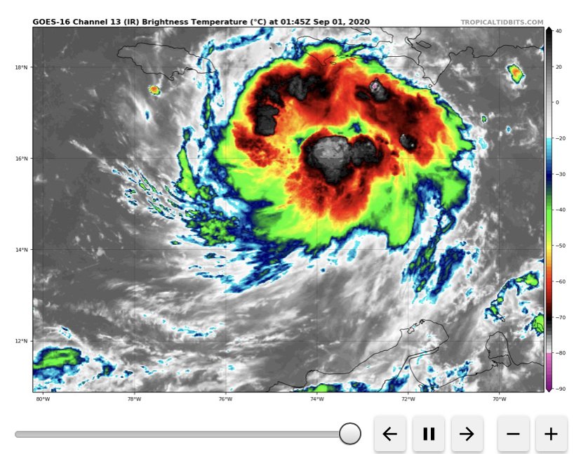
I’m anxiously watching to see what they find. This is a beautiful satellite appearance to not have a closed center. Has expanding outflow and persistent deep convection where you’d think the center should be
-
3.19” for the day and still coming down. Over 2.50” last 2 hours
-
99L looks healthy tonight.
-
Could see 2 more named storms in the next 12-24 hours. 99L has some potential to make a run at becoming a hurricane. 90 will be a wave producer on the east coast. Both look robust at the moment for invests. Hopefully 99L continues its rapid pace of movement to decrease strengthening and also flooding issues where it makes landfall in Central America
-
Hot towers going up over the center. First time this system has looked like a TD. Let’s see if it can continue the organizational trend.
-

The "Double Trouble" Banter Thread
NorthHillsWx replied to Windspeed's topic in Tropical Headquarters
I think the potential for both of these systems to be much ado about nothing has increased markedly in last 24 hours 1) Laura- IF the system had organized and developed stacked vortices, it would have gone north of the islands. It did not and got whipped westward with the trade winds. It, still resembling garbage, has been named but it has guaranteed itself significant land interaction with possibly every major landmass in the Caribbean. This system had potential entirely based on it staying north of the islands and interacting with an upper level snticyclone with potential for optimal outflow and light shear an a few days in the vicinity of the southern Bahamas. Given that did not happen, this system is doa until *possibly* entering the gulf if it can keep somewhat of a circulation it can build off of once it leaves interaction with Cuba. 2) TD 14- this system is a prime example that it takes prior organization to exploit favorable environmental conditions. If this had been an organized TC in its current location, it would be strengthening on approach to the Yucatán, possibly significantly. It, however, is using its time over water just to organize into TC. Unfortunately for the system, it’s time over water will be cut short so the bar for strengthening is lower. After LF in the Yucatán, it will once again depend on the storms structure for how quickly and how much strengthening can occur. Though I believe the models to be overdone on the amount of shear, there will still be considerable SW shear, continental dry air, and possible negative interaction with whatever remains of Laura. This system will not look like a classic cyclone on approach to the gulf coast and interaction with the trough and shear will probably make this a comma system. We’ve seen these Max out as low category hurricanes but that’s it. Simply put, the bar is not high for this one either. Im not ruling out the possibility one or both of these systems reach hurricane status (I think TD 14 has best chance) and a lot can change, but I do not think either storm has a high ceiling given the above factors. Laura’s Achilles heel being lack of organization at present and then land battles and TD 14’s being Yucatán and then a hostile gulf on approach to the US. I don’t see anyway either makes a run at a significant hurricane now and I think most guidance has performed fairly well with keeping these systems in check for a reason. -
Props to NHC for forecasting and not Just model watching. This system had very little model support when NHC gave it the cherry
-
CMC solution of multiple TC’s in GOM at same time is quite interesting. No reason to focus on model to model runs though. Signal is there for tropical cyclone genesis and very little to no chance of recurvature with that massive blocking ridge in place. As said above, could get interesting this week.
-
Based on satellite and radar, I believe we have another storm off the east coast... Here in Nags Head for the week and you wouldn’t know it. Very little swell, few rain bands moving through.
-
Love people declaring the season a bust when we’ve already had over $5 billion in US damages alone, record breaking 10th named storm by August 13, more than a week ahead of 2005, and seen storms popping in even unfavorable conditions. Wait till the Atlantic gets right here in a couple weeks...
-
Small low pressure formed just off the N.C. coast south of cape lookout this morning. If this had more time I’d bet we’d have a quick TS spinup again. Accompanied by 30-35 mph wind reports.
-
They’ve been atrocious with storms this year. But, they do not get into the meat of the favorable period as advertised by the above posts even in their longest range.
-
I thought y'all would see hurricane force gusts the way this was intensifying coming ashore. Glad it wasn't as bad as it could have been!
-
Picked up 3.20" imby. No sign of any wind coming through and central NC gusts I've seen were less than impressive, highest I've seen was 47mph in Goldsboro. Higher Wind gusts from this storm seem to have been extremely spotty and mostly relegated to the coast. Some scary pictures of tornado damage coming in. Just saw the Bertie county tornado damage on WRAL
-
Pouring rain. We’re around 1.25” so far. No wind yet. Going to bed, stay safe everyone
-
Track has shifted ever so slightly East again. Also now explicitly forecasting a hurricane at landfall. The East shift may spare the immediate triangle area the worst of the damaging gusts. I think 50-60 mph would be high end with this track but likely 45-50 mph. Places further east say Goldsboro/Wilson could see gusts to 70. This could be a very disruptive system for central N.C.
-
The threat for a fairly significant inland impact with this system is increasing in central North Carolina. The entry region of the jet streak combined with the track of the system is set up well to expand impacts on the western side of the storm. This may also lead to a period of intensification on approach to landfall. HWRF and ukie cannot be completely ignored. Tropical storm watch was just issued for wake county and this setup really reminds me in a lot of ways of the Matthew setup but the storm track is inland this time. I would expect some areas in central N.C. see gusty winds up to 50 mph which, combined with 2-4 in of rain may be enough for power outages. At a minimum this will saturate the eastern half of the state which has missed out on most of the recent rain and could set the table for more impactful rain events as we move into the meat of an active hurricane season. Long story short, I am anticipating an enhanced impact in central NC than we would usually expect for a system of this intensity
-
Our wet period advertised all week has fizzled to 20-40% chances on NWS as most of the energy impulses look to stay in Virginia. Funny how all these advertised big rain events have quite literally dried up and we get our most widespread rain event of the summer with a modest 30% rain chance the other day... A humid 81 at the moment praying for some clouds this afternoon otherwise we will be roasting in this humidity
-
Yep going to get the boat off the lift in Morehead. Don’t expect anything crazy though
-
Wonderful: It`s looking increasingly likely central NC will remain under the stronger influence of subtropical ridging, which will keep the majority of upper impulses north and west of the area. So what look like a fairly wet and active a few days ago, is now looking more like a typical summer day, with the Piedmont trough and strong daytime heating providing the focus for isolated to scattered convection. Cannot rule an isolated severe storm, mainly near the VA border where models show a band of enhanced shear of 25 kts. One negative aspect of the lower rain chances, is that it will be hotter, with afternoon highs back in the lower to mid 90s and heat indices back in the 102 to 105 across the central Piedmont, Sandhills and coastal plain counties. Lows in the lower to mid 70s.
-
NAM doing NAM things this run, lol
