NorthHillsWx
-
Posts
5,367 -
Joined
-
Last visited
Content Type
Profiles
Blogs
Forums
American Weather
Media Demo
Store
Gallery
Everything posted by NorthHillsWx
-
ACE is a useful tool but it certainly doesn’t tell the whole story. We’ve had extremely high ACE years with barely any impacts and low ace years that we’re high impact. It also doesn’t do late blooming storms justice, like Laura. Also, you can have 1 or 2 storms produce basically an entire seasons worth of ace and then have a slow rest of the season.
-
Well I don’t think anyone can complain about this hurricane season, 2020 has literally had something for everyone. If you’re a numbers person, we’re going on the “w” storm halfway through September. You like high end hurricane landfalls? Laura. You like disorganized spinny thingies with names? You’ll be set for 3 years. East coast metro hit? Isaias produced hurricane force gusts from N.C. to MA. Long track MDR storms? Paulette and Teddy. High end fish storm, watch teddy this week. Hurricane landfalls? Every single hurricane has hit land. Teddy may too. Rapid Intensification? Check. Survivalist storms? We’ve had two hit the tallest peaks in the Caribbean and STRENGTHEN after doing so. You a person who loves strengthening systems on approach? Check check check check check check. Preseason named storm? Yep. Needle in a haystack storm? Paulette making landfall on Bermuda. Slow moving epic rain producer? Sally. Ridiculous storm surge, thank you Laura. I mean, we’ve had everything for everyone!
-
From a hurricane warning to a sunny day
-
Yep, GFS actually brings it near to where sally made landfall, stalls it out, then loops back SW. I think a wide range of track possibilities are on the table. Models definitely sniffing this one out though, unlike sally
-
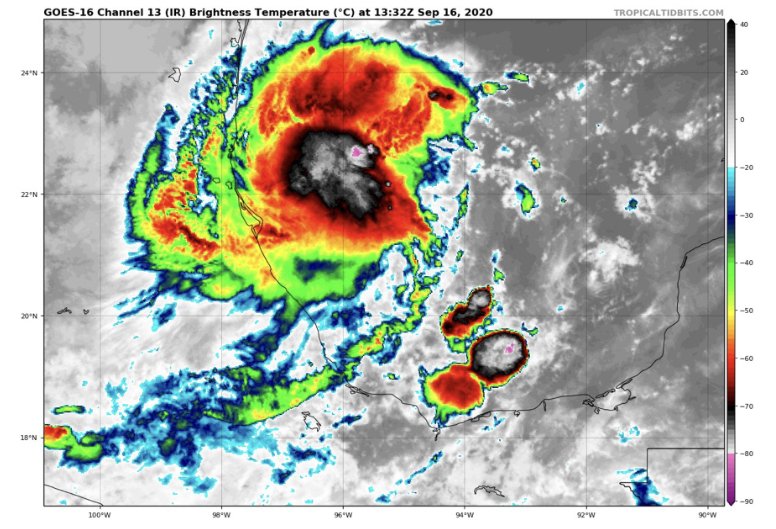
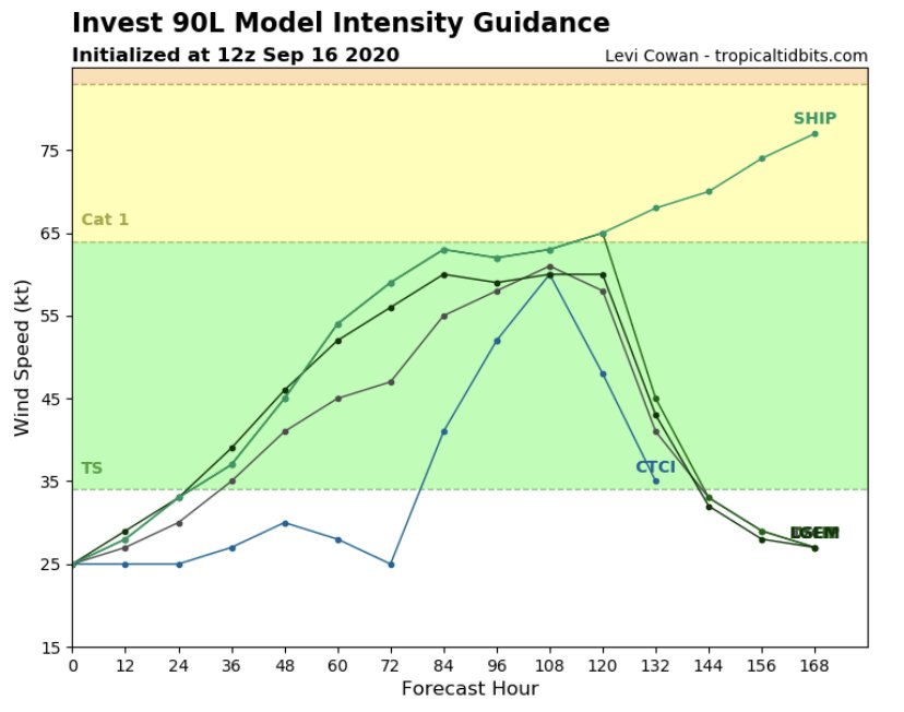
I’m going all in on 90L. Bathtub water, decreasing shear, unstable air mass, and location location location. SW gulf is a hotspot for quick spin ups (orientation of geography?). Given the well organized look seen this morning would not surprise me that any additional increase would lead to formation of a TD by tonight. I think 90L wins the race for “W” and I think it could also become our next hurricane. Going to be a painfully slow mover and since no vortex exists yet models have taken up almost every inch of the western gulf for possible tracks. I personally think a long northward trek into Texas is most likely, but will need a defined coc before we know anything on that front
-
Impressive satellite appearance on IR
-
Already some model support for development. Intensity models generally show strengthening until landfall
-
Yes, it’s a good thing we cancelled this season halfway through August because the globals weren’t picking up on development. I can’t imagine if this had actually turned out to be an active season!
-
Teddy should get us there alone
-
Honestly we may need a thread for 90L. Looks robust this morning. Models have slowly been picking up on it, albeit weak, but as we just learned: never trust a gulf system. Another slow mover that may eventually work towards the Texas coast
-
Pretty sure that weather radio is older than you. It still works too, listened to it at the beach a few weeks ago
-
I still have my NOAA weather radio with extendable antenna. One of my favorite parts of the summer was waiting for the new tropical updates, while going through the entire area forecasts and marine forecasts, to get coordinates to track storms. Didn’t have tacks but did have a dry erase map of the Atlantic basin and paper maps I drew on. Would love to find my maps from the 1996 season
-
Yes, Michael and Laura were total works of crap. I only respect dorians rolling straight into New Orleans with 35 foot surges and *recorded* gusts exceeding 200 mph with ground scarring as evidence and automobiles wrapped around trees with the tailgate touching the bumper, because anything less is more indicative of a cat 1
-
This storm’s banter thread makes it a category or 3 higher in terms of human impact
-
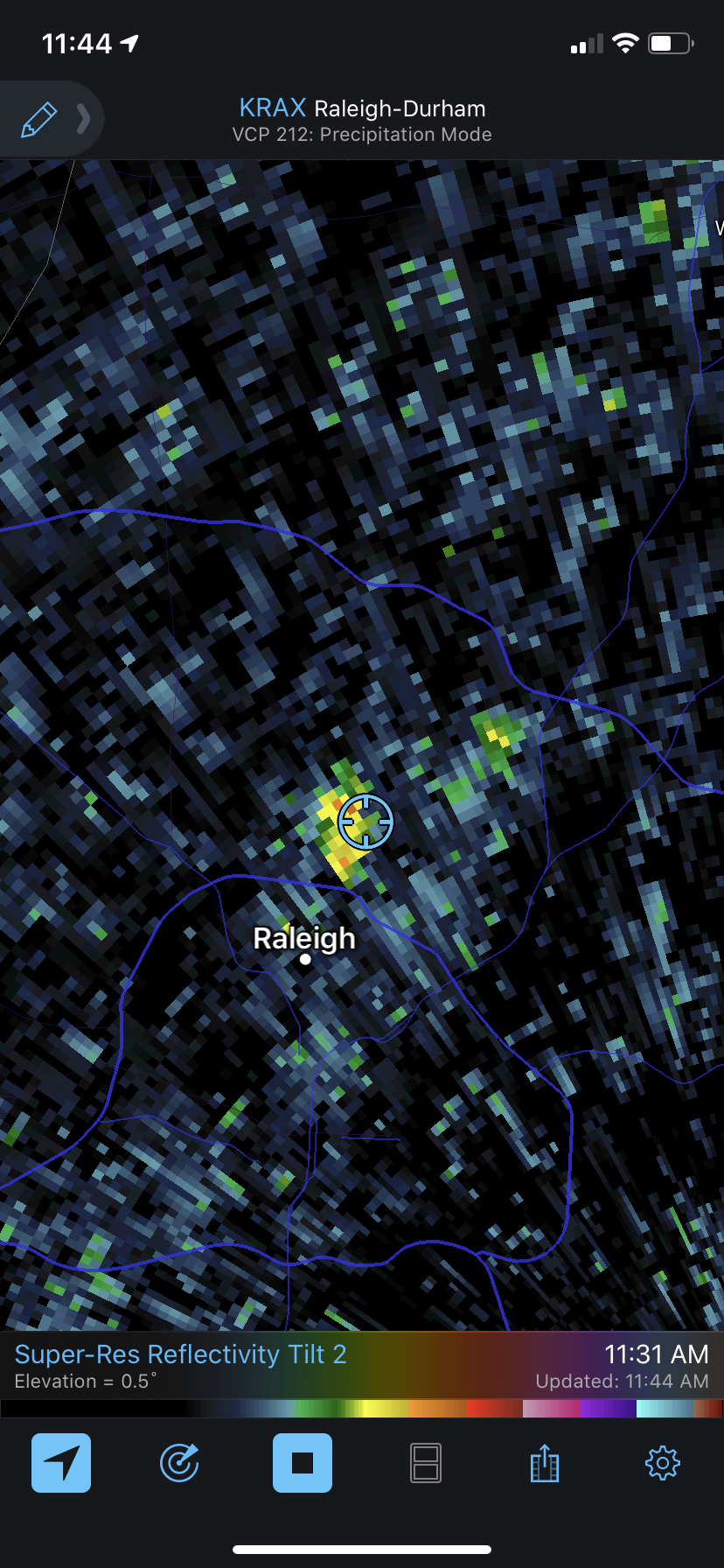
Finished with 0.45” for the day
-
Had a shower about the width of my yard sitting over the house for last 20 minutes dumping rain. Not raining down the street but I bet we get a quarter of an inch

-
0.09” 24 hour total. Muggy as can be
-
Hits a brick wall
-
The crazy thing about that run, well besides 3 hurricanes lined up in a row, is it doesn’t landfall any of them haha
-
Idk it looked pretty robust coming ashore... Saw a 61 mph sustained wind report noted in the advisory. Being the system was tiny the chance of that being in the strongest winds seems very remote
-
NHC earning their pay this season. Every one of their forecasts defied the models up until the very end for Nana. They’ve been incredible this season
-
Hurricane Nana
-
Yep, shear is going to win on this one. Levi’s discussion last night about the northerly shear imparted on the system by the ULL was spot on. Center has become exposed.
-
In the discussion it says the system is expected to become a hurricane though the time interval this will happen is not shown
-
Picked up right at 4.00” yesterday. Though humid, was nice today with low stratus cloud cover hanging on past noon. Currently 81 with a pretty sunset on the way