

NorthHillsWx
-
Posts
5,367 -
Joined
-
Last visited
Content Type
Profiles
Blogs
Forums
American Weather
Media Demo
Store
Gallery
Everything posted by NorthHillsWx
-
Give this thing 24 more hours over water and we may very well have a cat 5. Most explosive strengthening of the year ongoing on November 2nd. Bet the next flight finds a major
-
Pretty impressive October snowfall going on in southern New England. From a hurricane to an east coast snowstorm. Hopefully that’s a sign we can get some coastal storms despite La Niña this year. One can only hope...
-
I think Zeta, Sally, and Paulette all stand a chance to be upgraded to majors. Zeta and Sally have the highest chance because the amount of wind damage to assess and sample size will be much greater. It’s semantics but looking at 6 majors instead of 4 would make quite a difference on the perception of an already epic season
-
Pretty awesome hurricane footage
-
430k outages in NC right now
-
428,000 outages in NC on the Duke system
-
Probably 40-45 mph wind gusts. What the advisory had called for. Calmed down now. Still wondering why the upgrade to the high wind warning
-
I know, the western part of the state was always supposed to get that. It’s kicked up last 30 min. Nothing bad but gusts 25-30 for sure. Leaves blowing around good
-
High Wind warning now up for the Triangle with gusts to 60 mph possible. What changed? More efficient mixing of winds to surface with daytime heating? Not seeing any wind reports near that downstream of us in Raleigh
-
Nowhere near the same. This is an average sized storm booking it with winds picking up at very end. Katrina was a mid gulf monster and had days to buildup that massive surge. Not fair to even include this in the discussion with the K word down there
-
Would be the shortest thread of a major US landfall in AmericanWx.com history
-
No chance at cat 3. I’m only saying I do not think this is going to weaken. It’s still (slowly) deepening and sat presentation has improved since this morning. It only has maybe 6 hours until the eyewall is onshore
-
The problem with this graphic is that the first forecast point, 12 hours, the storm is already inland
-
This is not the same look delta had coming in. This is a well formed strengthening storm. Conditions won’t permit it to go crazy but this is still strengthening and has just about run out of time for any weakening to take place
-
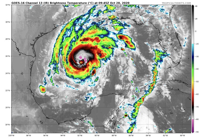
On another note, the eye is now becoming visible on the long range LIX radar.
-
I think it, presentation wise, looks the best as it has yet. The deep convection is more consistent, it had that popcorn look when the eye feature was more pronounced, and it is popping an eye on visible as we speak. Recent trends and forward motion, I don’t see this weakening. I think cat 2, 85 kt landfall
-
-
NHC now going with 100mph near landfall
-
Me thinks intensity guidance is gonna bust low low after what I’m looking at tonight on satellite
-
Agreed. If this convective flare up persists, it seems it will, those pressures will come down quick. That’s a large amount of heat being expelled into the atmosphere
-
Pretty amazing we’re looking at our 6th US hurricane landfall this season. I know they haven’t all been blockbusters but Laura, delta, Isaias, sally, and now probably zeta would be bonafide headliners by themselves in any season on this forum. We’re spoiled
-
New, stronger convection is beginning to fire near and around the center. The next 8-10 hours should give us a good idea where the intensity bar is set, though I still think there are enough positive factors going for this to be a stronger system than what these show. I like 70-80kts
-
Zeta has developed an extremely impressive outflow pattern since last night. However, convection is struggling mightily near the core and a large moat has developed between the central convection and a cyclonically curved outer band. I believe we’ll see the outer band structure decay over the next 12 hours and an increase in convection over the center as that occurs. SST are sufficient and with the outflow pattern, I do expect strengthening to occur. However, the system took more of a hit over land than it seemed while over land. This spread out structure will take much longer to coalesce and see a quick uptick in intensity. I predict a slowly organizing system to peak and then stay at similar intensity through landfall. Probably on the order of 70-80kts. If this had a better structure I would be concerned of a stronger system but it will take considerable time to reorganize in its current state
-
Getting in the eyes of both delta and zeta in Mexico with no radar, no well defined eye on satellite, and both being small eyes, is extremely impressive. This storm was ramping up it just ran out of water. GFS is interesting, it deepens the system through landfall. I’m wondering if the increased forward speed will mitigate the time zeta spends in the cooler water/higher shear environment thus negating those weakening factors. The shear vector also is in line with forward motion which could mitigate that impact as well. This to me looks like a “solid” cat 1 landfall in Louisiana
-
Epsilon looks pretty healthy this morning. In a season where hurricanes have struggled to maintain an eye for long stretches, thus storm is the exception


