NorthHillsWx
-
Posts
3,964 -
Joined
-
Last visited
Content Type
Profiles
Blogs
Forums
American Weather
Media Demo
Store
Gallery
Everything posted by NorthHillsWx
-
 Any chance the center of Karen re-forms under that persistent area of deep convection where the MLC appears to be located, from the sat loop? Shear appears to be lessening and this has been the most vigorous and persistent convection of the system so far.
-
We've had some dry periods but this is definitely going to be the first chance at a full-blown aerial drought in quite some time here, unfortunately. Last few years being so wet made us spoiled in regards to being above average for precipitation. Thankfully it is in the autumn after the growing season for farmers but it is DRY. Warm again today but not as bad as yesterday. Currently 83. Bring on a real cold front please! Pretty easy to see the ridge placement on the GFS total precip map through the end of the run. Sheesh!
-
Well, was hoping for 40's this morning. Didn't get close. 55 low here (I think RDU got a few ticks lower). Very pleasant regardless! DRYYYYYYYYYYYYY
-
Mid to Long Term Discussion 2019
NorthHillsWx replied to Upstate Tiger's topic in Southeastern States
Hopefully a wet pattern starts soon. Not seeing much hope on the models. Keep checking back hoping for a change. Only good news is timing for duck season. Going into duck season it's going to be very little water (opposite of last year). Birds are going to have fewer places to go so hopefully my farm which has great beaver swamps that always hold water will have more birds as they will be less spread out and more prone to use continual sources of water, Looking at the positive of this! -
2019 Atlantic Hurricane Season
NorthHillsWx replied to AfewUniversesBelowNormal's topic in Tropical Headquarters
Whew, today certainly became a fun day on the tropical front! Rapidly forming TS, New TD on it's way to becoming a hurricane, and Humberto growing and making it's push to a major while threatening Bermuda! Also plenty of development in the Eastern Pacific... It's like it's mid-September or something! -
2019 Atlantic Hurricane Season
NorthHillsWx replied to AfewUniversesBelowNormal's topic in Tropical Headquarters
Just like that, NHC has designated a TD. Expected to become a storm shortly. Pretty interesting to watch the rapid organization over the last 12 hours. Big rain-maker for Texas -
Ready for the ccoldown! A warmer than expected 91 imby! Per ususal
-
2019 Atlantic Hurricane Season
NorthHillsWx replied to AfewUniversesBelowNormal's topic in Tropical Headquarters
Looks like we have a TD on the Texas coast, per Houston radar. Not much time till it moves ashore which is pretty lucky as it is organizing rather quickly. If it was slightly further offshore I'd say a 2007 Humberto-like system could be in the cards, very similar organization and location -
Mid to Long Term Discussion 2019
NorthHillsWx replied to Upstate Tiger's topic in Southeastern States
I'm surprised we're even that close to average in central NC. We did receive 1.5" from the hurricane but that feels like a century ago. Coupled with the high heat, we're in mid-summer form in terms of the yard browning out -
Mid to Long Term Discussion 2019
NorthHillsWx replied to Upstate Tiger's topic in Southeastern States
One word sums up the upcoming and recent weather pattern quite nicely: Dry -
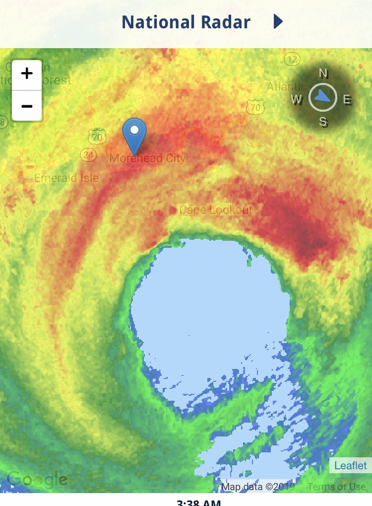
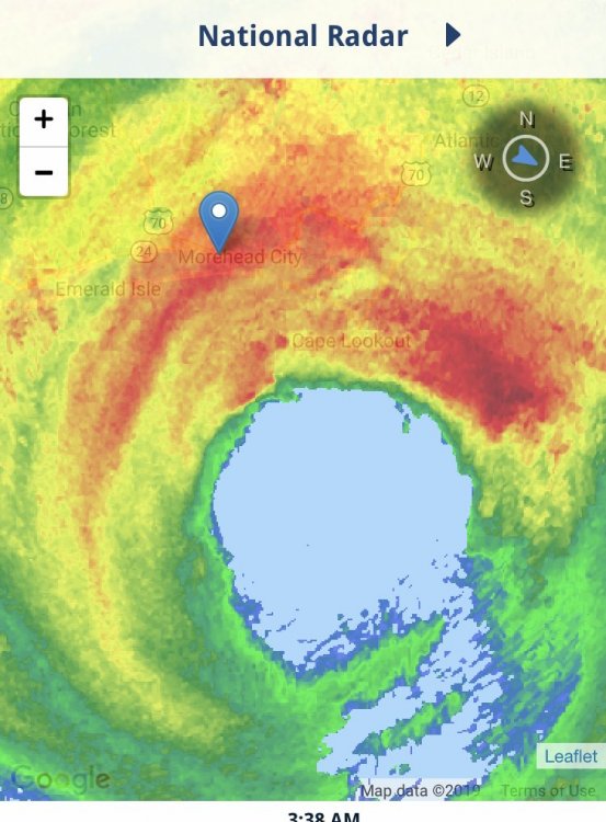
Rode the storm out in Morehead City. Gusts peaked between 4:30-6:00 this morning. Guessing gusts in the 80-90 mph range. Lots of branches and leaves down. Lots of transformers exploding and arcing. Got that jet noise you only get over hurricane force. Genuinely doubted we’d see hurricane force winds as the lead up was so tame but we definitely had a period when sustained had to have reached that level. No clue on rain but I’d guess it’s have to be around 5 in. North eyewall was surprisingly weak. Western side brought the goods, well what was left of them anyway. Most areas do not have power. Damage very minimal and no water rise. Very thankful this thing lost the fury it had down south. We didn’t need another big hit. Oh yea, my neighborhood kept power!
-
We don't have AC so power isn't really an issue. Got several YETI's I can fill with ice. I'm pretty much directly across from the bridge to Manteo so getting off the island shouldn't be an issue. Wasn't planning to leave until Sunday anyway. Even with Isabel this spot was not hit hardm outside the main beach road. We own the lot behind us and can park cars there assuming any overwash makes it under this house, which would require a 6-8 foot surge and I don't see that from a storm coming from the SW instead of the east. I think southern beaches and Hatteras have much more impact.
-
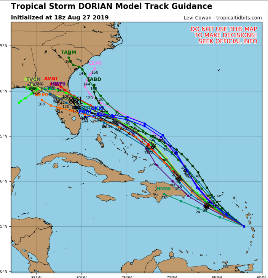
A common subject on the main thread has been model performance but I do not think they have performed as poorly as some on the rhetoric emanating from there. Storms rounding a ridge are notoriously difficult to predict where the northward turn begins. The new GFS, in particular, was one of the first to identify a slowdown and turn before the mainland. I commented on the thread Friday that this was noticeable, despite most of the operational means still showing a track well into Florida. Once most of the models on Friday showed a stall and a turn North, details are everything but well within what I would consider the 3-day margin for error. it just mattered more because of the implications of where the turn happened. If this was in the middle of the Atlantic, no one would notice. But being the difference in 80-100 miles meant a monster storm sitting over Florida or sitting in the Bahamas this was extremely seen as poor model performance. I disagree. From Thursday night through now (Tuesday) I do not think they missed by much at all. However the margin of error was so thin and consequences at the coast so dire that it amplifies any model errors. Just my .02!
-
I've been disconnected for a few days here in Nags Head (got engaged!) really trying not to think about this storm messing up the second half of our vacation but we were placed under a mandatory evacuation for non-residents yesterday. Being my family owns a home, it does not pertain to us. To me this looks like the prototypical NC cutter storm. A sloppy hurricane feeling continental dry air and westerly shear being pushed ots. You can see the models all make this an extremely lopsided "half-a-cane" by the time it gets here Interacting with the trough it has a heavy rain band on it's NW side and very little activity on the south and east side. This is what I expect the storm to evolve into once it gets ejected into that NE trajectory. Key Questions Though: 1) How much wind energy will be retained? If I was a betting man I would say this would be an 80-90 mph storm by the time it gets here. It's former state has zero bearing up this far as it will be in an entirely different set of atmospheric conditions (and it is already rapidly weakening) 2) How much rain will be generated inland? If that NW band develops I'd expect some 10 inch amounts. Flash flooding becomes a main issue 3) Will it make LF and does it matter? A lopsided system spreading out wind energy with the north and west sides being strongest will not need a proper LF to see the main impacts. 4) How long will impacts last? Storm really looks to be honking by the time it gets here. This may be a quick 12 hour event with a 2 hour heavy blow. 5) The money question: Should we leave? Saturday and Sunday after the storm look wonderful. My house is on the water but has weathered far worse impacts (Isabel being the worst) and this does not appear to have the same bite. I am having a tough time leaving tomorrow thinking about getting so see some nice winds and having a beautiful weekend with the beach to ourselves after the blow. Thoughts?
-
Purely speculation but this storm feels like a Matthew track to me. I've been saying that since the first member started advertising the northward bend yesterday morning. If it slows down, it is going north. That's just what these things do. And I'm supposed to be in Nags Head all week so I KNOW its coming north haha
-
I said this earlier. If it slows down, it gives more time for it to find a weakness in the ridge. That is exactly what changed overnight. It slowed down a good 18+ hours. Where the western periphery of the ridge sets up is absolutely critical. Also, a slow system + frictional effects with land can end up delaying LF further north as well. We certainly saw this with Matthew. It's only 75-100 miles inland at most on these runs now whereas yesterday many had it going into the gulf. The only good thing about this track is storms that slow and linger on approach to the east coast tend to ingest dry continental air and weaken before LF. It this thing slows to a crawl I would doubt it will come in at peak intensity, especially if it comes north. Obviously that's a sidenote as we saw what Florence (and Matthew) did as a modest 1.
-
Right in Michael's impact zone. Thankfully this is a week out and will likely change. A strong ridge north of the storm would certainly push him into the gulf.
-
Very impressive ridging.
-
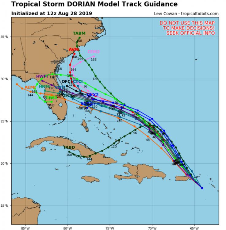
This is really ramping up into a scary situation for the Southeast, again. Dorian was able to avoid all major landmasses, go north of the most hostile shear, develop a core, and now appears to be entering an area of very favorable upper level outflow aided by good divergence from the ULL to the west. Rather than a small system completely re-building its core (track a few days ago) Dorian now has jet fuel to work with and a blocking high that seems intent on sending him into the Southeast somewhere. I think this is the moral of the story today. We are staring at a significant hurricane impact for the southeast. Models seem to be zeroing in on Central/North Florida but I would say anyone up to Hatteras is still in play. Upper air data input into models will start to tell the full tail on that front.
-
Blustery in St. Thomas! https://www.earthcam.com/world/virginislands/stthomas/?cam=stthomas
-
Yep. Slower = LF further north. Faster = freight train running into FL scenario. Still looks like steering collapses after LF and this thing sits somewhere for a good while and dumps rain. That threat certainly might need to be emphasized in the coming days if these trends continue
-
Frances and Jeanne say Hi!
-
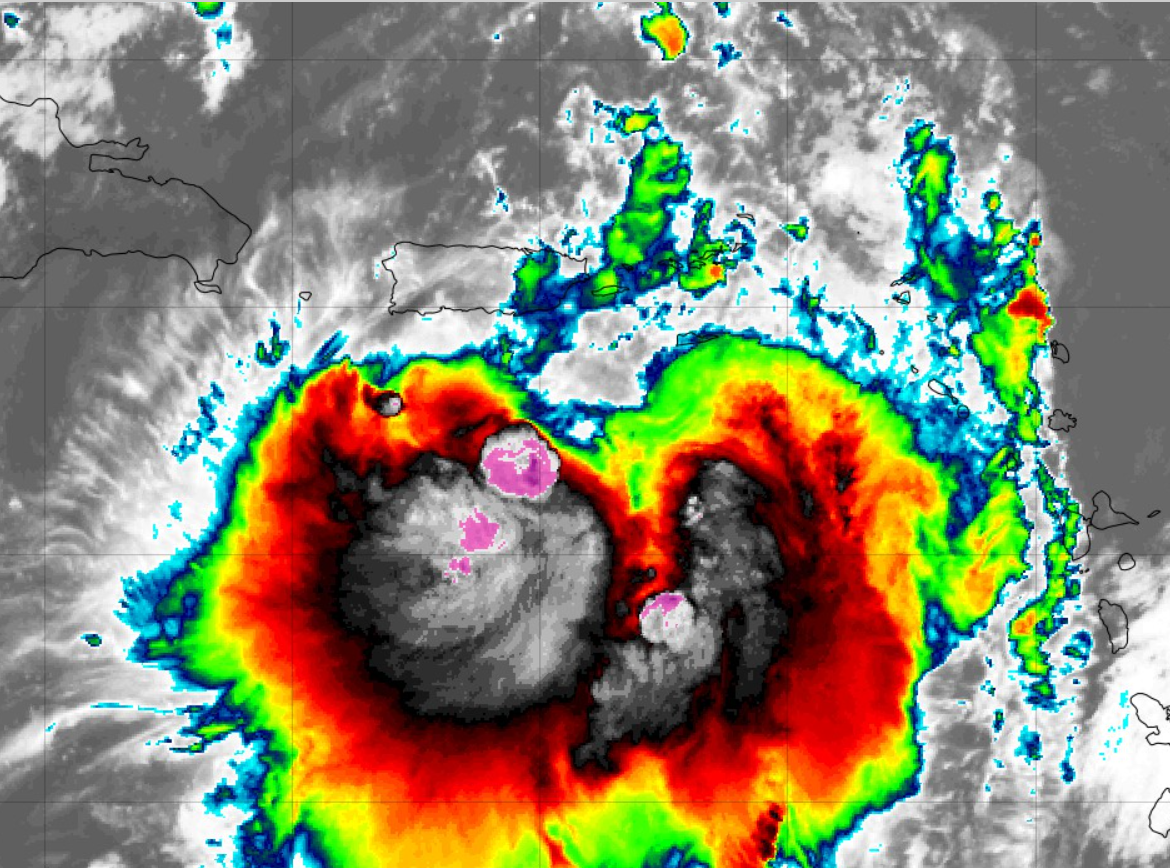
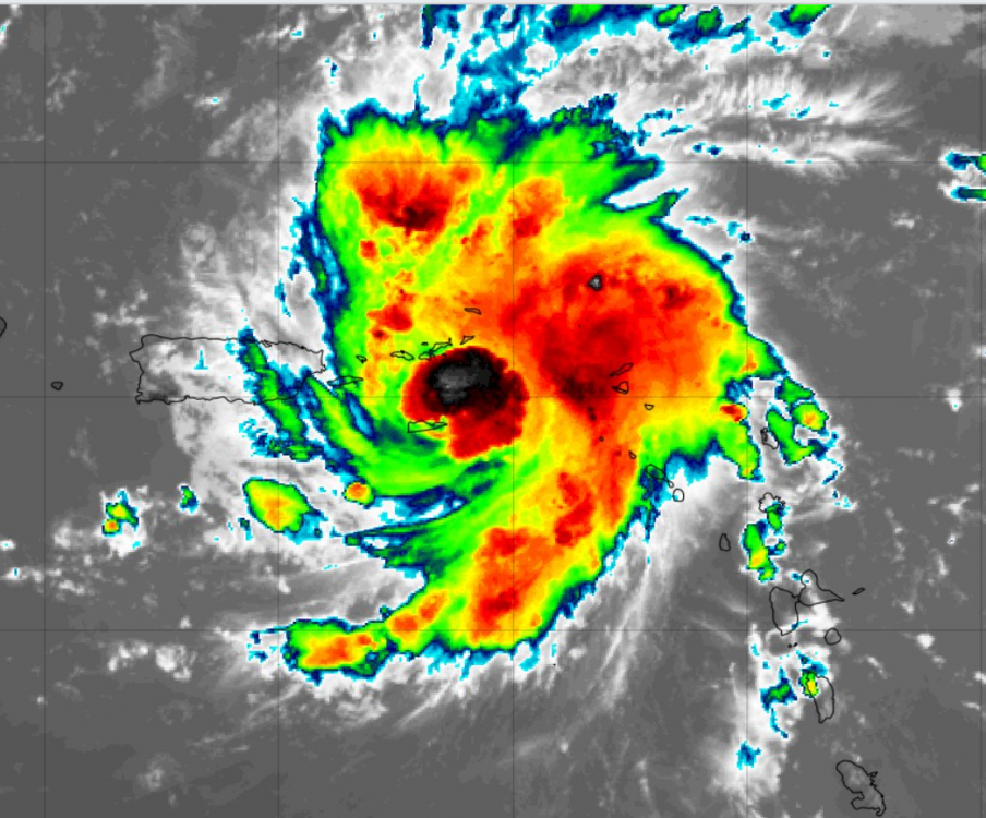
Last Satellite shot is foreboding for strengthening. He finally has that "look" and with the recent blowup right on the center, I wouldn't be surprised to see a period of at least steady strengthening. This is the first real "core" we've seen with Dorian.
-
Not liking the models this morning. Usually a "hint" of a northward move turns into a trend. Someone said it great earlier and I think using Matthew as an analogue is fairly accurate. It all depends on the western extent of the Bermuda High. Forecasting where a storm will round that is one of the most difficult things in tropical forecasting. If this storm slows down it may allow time for the ridge to weaken, then the Matthew-like scenario plays out. I strong ridge sending a hurricane hurdling straight into the Florida coast, like seems to be the consensus on the main board, is certainly a possibility, but the modeling this morning has opened another pathway. A HP with some of the height rises the Euro is showing is certainly impressive and does bring back a setup similar to that of Hugo. Look at the globals for this morning compared to 18z last night and you will see 2 camps setting up... Also, I am on vacation in Nags Head next week so I'm sure it will come to NC... Also, at Duke, we are on storm activation as we have territory pretty much in every place this storm is taking aim at, so I may not have vacation regardless of track!

-
Got up to 82 before clouds moved in. Currently 78, cloudy with a steady NE breeze. Unreal stretch of weather!