NorthHillsWx
-
Posts
3,964 -
Joined
-
Last visited
Content Type
Profiles
Blogs
Forums
American Weather
Media Demo
Store
Gallery
Everything posted by NorthHillsWx
-

Mid to Long Term Discussion 2019
NorthHillsWx replied to Upstate Tiger's topic in Southeastern States
Haha if this was a winter storm this map would be right where you'd want it the triad! -
Mid to Long Term Discussion 2019
NorthHillsWx replied to Upstate Tiger's topic in Southeastern States
Still no drought relief on the 12z GFS but man is that a stout trough digging in at the end of the run! Would be our first chance at frost in some areas if taken verbatim...
-
Mid to Long Term Discussion 2019
NorthHillsWx replied to Upstate Tiger's topic in Southeastern States
Like a broken record, SE ridging keeps the storm track above us with coastal development too far offshore to get significant rain into the lee of the Apps. This has the markings of a significant drought for much of the Southeast. The areas of severe drought have continued to expand. With no significant change in sight, I would look for that to continue.
-
Picked up the first measurable rain since Dorian overnight and yesterday afternoon from the heavy mist that occurred all afternoon. A drought-busting 0.01" lol. In all seriousness it was nice to have some of the dust knocked off the truck, but wow it has been dry.
-
Only records we can break these days
-
Frontal Passage is going to be slower than initially thought, allowing much more warming than forecast a couple days ago. I feel like we've heard this before...
-
2019 Atlantic Hurricane Season
NorthHillsWx replied to AfewUniversesBelowNormal's topic in Tropical Headquarters
Still some hints of possible development in the Caribbean Sea towards the end of some model runs. The African wave train has slowed and we are getting out of the MDR season. I would focus on the Caribbean, Gulf, and Atlantic Coasts in the coming weeks, especially if some of these first fronts of the season making it through hang up over the warm waters of this area. I think we will still see a few more systems before all is said and done -
I don't know if it's 100% accurate but it's by FAR the hottest temp I've ever recorded on my at-home thermometer in the shade behind my house but I hit 104 at 3:30 today... At least 100 at RDU it may not be crazy. Down to 98 now.
-
This would be a hot period in July, for October it's truly exceptional. Hoping and praying the cooldown comes with some rain chances. It is bone dry. On a side note, the farm got a surprise storm and what looked like .5" of rain (I don't have a guage out there, basing entirely on puddles). Also, my prediction on ducks came true today. As everything around has dried up and my farm's beaver swamps are some of the only holding good water, we almost had a 3 man limit this morning before work.
-
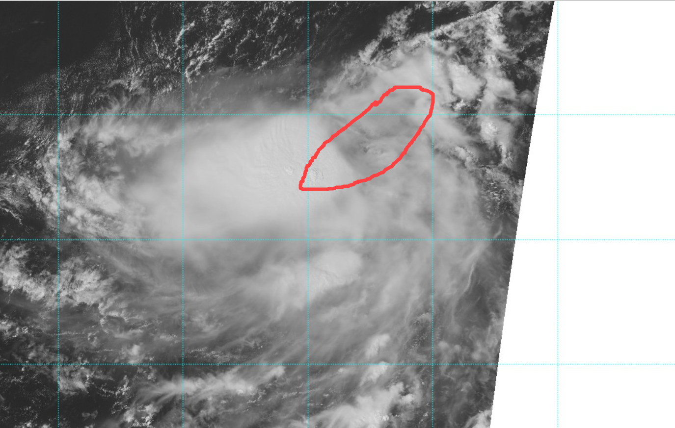
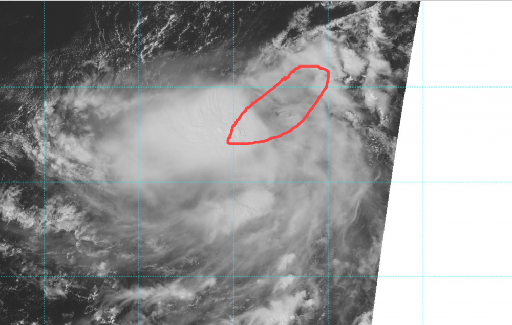
Lorenzo looking healthy atm. Clouds have actually cooled near the center and the eye is fully surrounded by deep convection, and seems to be clearing out somewhat on visible loop. What a powerhouse ACE storm! Been a heck of a storm to track.
-
Well, managed to make it through September with a grand total of 2 days with measurable rainfall. Both of them same event (hurricane Dorian). Only got a T of rain from the storms Friday night as they moved just east of my location, though some areas did OK with that. Still, this is the driest month in quite some time with 1.24" total and being that came from one event and had extremely dry antecedent conditions beforehand, I can say we are in full blown drought. An interesting observation, I took my grandfather to the farm yesterday (They actually only received round 1/2" total this month) and while driving in the dirt road, noticed all the leaves are grey. It was an eerie image coming in with the off-color leaves. Took me a minute to realize that the coloring was from the huge amounts of dust being kicked up by passing vehicles and landing and accumulating on the roadside leaves. Haven't seen that out there. Might need to take a picture next time, it is wild how much dust and how high up it is making it on the roadside foliage!
-
Too bad Lorenzo is weakening before being sampled. That would have been an excellent specimen at peak intensity.
-
Karen is dead. Disorganized swirls this morning. I'm struggling to find a tropical system at the moment. She had a nice run as Long-Lived TS, lol
-
Mid to Long Term Discussion 2019
NorthHillsWx replied to Upstate Tiger's topic in Southeastern States
Bring on the drought of 2019... Hopefully the change to cooler includes an active coastal pattern for a soaking rain. Rain associated with frontal passages is not going to cut it. Need soaking-type rains now.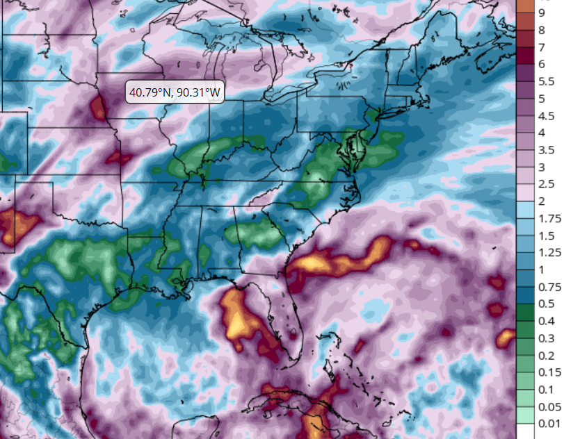
-
Given the high rain rate and lack of flight level wind data to support this, I'm surprised that's not flagged
-
Since NCEP stopped automated posting of GOES products (Himawari products are still being posted at current time) to the SSD server, weathernerds.org began to use that color scheme as an option for measuring cloudtop temperatures. And yes, I agree, AVN a valuable tool if not a more scathing one for historical comparison. Anyway, my eyes and empirical obs in general are better suited for 40 years of AVN because that is what I am used too. Yep. I think it got brought up during Michael the appearance of storms today is more severe in some people's eyes due to the new IR images available. The AVN images are hard to beat though from a historical perspective, as you said.
-
Where do you find these classic IR images? That's more impressive to me than the new ones. Nostalgic but shows how powerful this storm is!
-
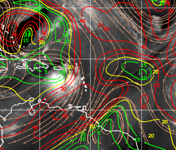
Looks very broad and weak. I'd imagine they haven't sampled the strongest winds yet though. Definitely elongated NE to SW. On another note, this has been an exceptionally long-lived 35-40 kt storm!
-
I disagree. I do not see a center under that convection. Looks like maybe the MLC. I think the LLC is broadening out and looking trough-like. Watch the visible for the real story
-
Holy Moly! Lorenzo has become the beast from the East! Though he won't attain the high-end winds of Dorian this is a sight to behold! A monster cane with very little threat to land, a tracking dream! Been explosive development though he's probably about maxed out. Can't take my eyes off that core. Man I would love to see a radar of that large core!
-
"Some Shear" is an understatement! The circulation is already stretched and being impinged on the NW from that firehose of shear at present. The sliver of slightly favorable conditions is so small it would take near perfect of the LLC to find it that it would have any benefit to maintain strength. Said it yesterday and reinforced today, despite the increase in convection: Karen is toast
-
If you look at the visible loop, you can see the cirrus clouds streaming from north to south over the mostly exposed circulation. That indicates the already weak system is experiencing significant shear. I do not see, from the analysis and current trends, a way out for the system. I may be wrong but also without any model support strengthening the system, my money would be this is an open wave at this time tomorrow.
-
That is about as unfavorable look as you will see for significant development, minus Lorenzo's little window. Karen has no chance.
-
I can remember, vaguely, the sound of raindrops falling in my backyard. Now, think I see a higher likelihood of this board reporting dust devils or tumble weeds then a raindrop over the next 10 days
-
Certainly appears to be through the worst of the shear, as noted earlier.