

NorthHillsWx
-
Posts
5,508 -
Joined
-
Last visited
Content Type
Profiles
Blogs
Forums
American Weather
Media Demo
Store
Gallery
Posts posted by NorthHillsWx
-
-
Tell me, what does the sanitarium trending “hot” after the 12z model runs mean?
-
Let me be clear- these are not imby posts. This has shifted from Blacksburg Virginia to oriental NC in 24 hours. You’re talking hundreds of miles and also even in the heaviest areas just a fraction of the QPF outputs from yesterday. This is not saying trends aren’t good for some on the board. Down east folks looking good for sure
-
 2
2
-
-
3 minutes ago, PackGrad05 said:
WRAL 12PM Update:
Wednesday 12 p.m. update: Good news for Triangle snow lovers
WRAL meteorologist Aimee Wilmoth said conditions this weekend are looking good for snow lovers but bad for road conditions.
"I am leaning toward more snow for the Triangle," Wilmoth said, adding that she has adjusted the winter weather map showing in blue (snow), pink (sleet) and green (freezing rain) what type of precipitation will fall where on Friday.
I guess everyone is banking on more expansive precip shield. Interesting
-
4 minutes ago, PantherJustin said:
And The model GOAT …. HRRR …. It was on an island of its own when Burrel started pumping it last Sat eve And it scored may as well give it a shot in our what have you done lately era
Burrel literally pumped it into reality
-
1
-
-
Just remember guys, fabulous February will save us

-
 1
1
-
-
It really may never snow appreciably in Raleigh again. I just don’t know what it will take. Striking out last weekend hurt but was tolerable bc we had the rug pulled out on like day 4-5 but to have the rug pulled out at 36 hours is stupid bad.
Going back your really have to go back a long time to find a good snow here. December 2018 was a hefty event but it almost all fell late at night and has changed to plain rain by mid morning which took a lot of luster from it
-
1
-
-
This is one of the worst modeled events in a long time. To see such drastic shifts inside 48 hours is for sure not the norm.
-
4
-
-
8 minutes ago, wx n of atl said:
GA recap from last winter storm.
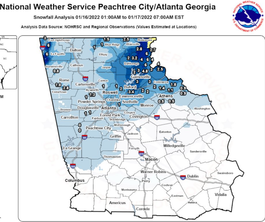
So ATL ended their snowless streak?
-
3 minutes ago, NCsandhills said:
It can be really disappointing more often than not. I'm still hopeful that we get at least 2" in Raleigh, and I'll be satisfied-ish with that. Of course, those 6"ers were beautiful to look at but...experience living here tells me it's too good to be true. When is the last time Raleigh got a 6"+ storm?
December 2018. Then had 6” of puddles in my backyard that evening after all the rain
-
 1
1
-
-
Just now, Brick Tamland said:
This was the GFS last night.
(5).thumb.png.769731612a343149c411bb27bffa00e0.png)
This was the Euro this morning.

Can't even have confidence in these outside 48 hours. That's terrible.
Pathetic
-
1
-
2
-
-
Just now, snowinnc said:
So how is it for the Raleigh/North Hills members?
Not good. 1-3” and we’re on the line
-
2
-
-
Given the 12z modeling and assuming these trends don’t correct this evening I could see RAH dropping watches west of Wake
-
12z Euro is a dumpster fire for everyone outside the costal plain. Look away now if you had anything invested in this Triangle west…
-
1
-
-
I claimed a spot at the first sign of trouble last storm but I’m staying out of the sanitarium this storm, going to stay positive. Oh wait, crap
-
4
-
-
1 minute ago, StantonParkHoya said:
Anyone have the UKIE snow map?
Almost identical to Canadian
-
1 minute ago, olafminesaw said:
Sounding that does not inspire confidence (although much improved a few hours later). We'll see hours upon hours of flizzard conditions, with a 3-6 hour window for light to moderate accumulations
.thumb.png.5dd0a6bb240900c4e457ba2e245a130d.png)
Yuck, talk about lack of saturation through the column. Definitely going to struggle on the outside edge of this. Very cold dry air
-
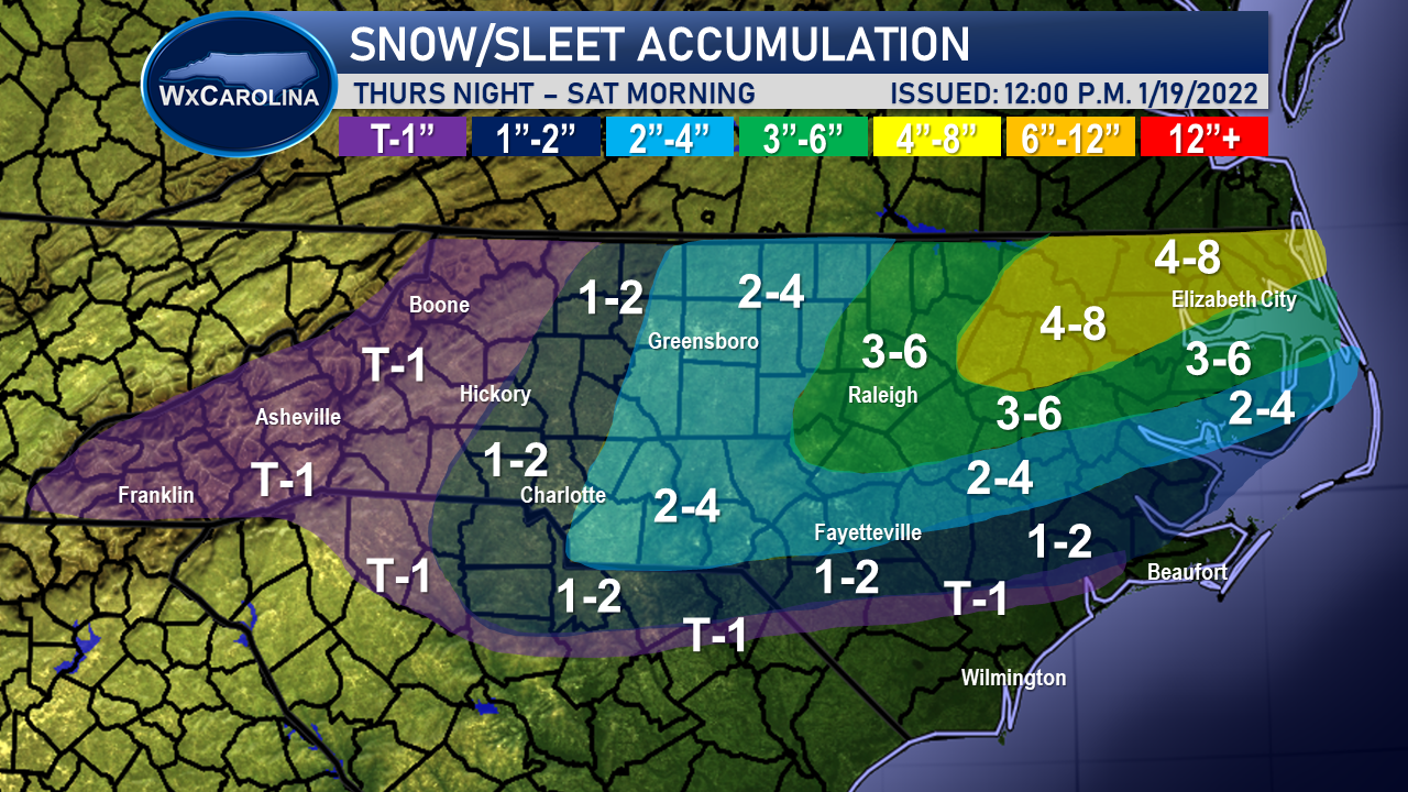
6 minutes ago, WxJordan said:
Below is my first accumulation map for the winter weather expected to impact the Carolinas Thursday Night through Saturday Morning. While I am not expecting wintry weather the whole entire time, waves of moisture are expected to cause periods of wintry weather.
The highest snow totals are expected in the northeastern part of the state. I am expecting 4-8 inches in NE NC. As we move towards the Raleigh metro, 3-6 inches of snow is expected. Lower amounts as you move further south, but these areas are expected to have more freezing rain. Southeastern NC needs to plan for the possibility of power outages with freezing rain possibly approaching a half of an inch.
For western NC and the western piedmont, lower amounts of snow are expected as you will be further away from the best moisture and low pressure center. A trace to an inch is possible in the mountains and foothills, with 1-2 inches possible for I-77, including Charlotte.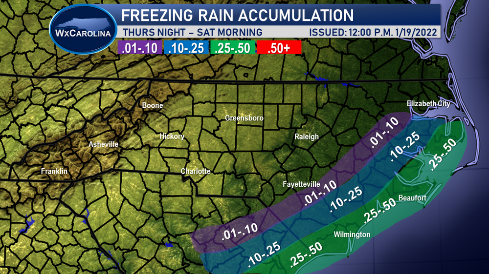

This would align with my thoughts, just take 1 inch off every total there across the board
-
1
-
-
Canadian STILL shows a 2-4” snowstorm for Raleigh.
I get it, the trends are concerning. I feel the same way. But even so, all the reliable models still align for a 2-4” snowfall over central NC…. A month ago we’d all be jumping for joy
-
1
-
-
1 minute ago, PackGrad05 said:
Yeah I don't get the doom and gloom either. A decent snow for Wake County is anything over an inch. That's just reality. This system is still shaping up to be a nice system, especially with temperatures, preceding soil temps, etc...
Snow sticking will not be an issue so I don't think we lose anything to melting.^^^this. We were looking at a 1-3” sleet storm 2 days ago now, a 2-4” snowstorm with arctic air and high ratios. I see nothing cataclysmic from the modeling at this point. Definitely on edge but we’re still in a good spot
-
2
-
-
GFS held serve. Beggars can’t be choosers, yes totals are not super high but RDU looks really good for a 2-4” snowfall and temps in the 20’s STILL despite the doom and gloom here. That would be an awesome storm
-
7
-
1
-
-
If y’all wanna see a migration to the sanitarium wait for the RDU folks to have gone through last weekends swing and whiff to the west then have a beautiful setup for days and days only to have the rug pulled out from under them inside 48 hours with a swing and whiff to the east
-
1
-
4
-
-
I will say this- I’m not pushing the panic button yet unless the euro/cmc cave at 12z. CAMs struggle with LP development due to convective feedback and we really aren’t in the timeframe thar is considered to be their wheelhouse yet. The 6z euro and 0z Canadian had actually trended very favorably from their previous runs. Definitely more on edge than 24 hours ago but still feel like central NC-east is in a good spot
-
5
-
-
A VERY good analog of this system in the January 28 event last year. Arctic front with late LP development along it. This storm has colder air to work with but dang the Synoptics line up incredibly similar to this setup and the snow map is very similar to what modeling is showing
-
17 minutes ago, VABILLUPS1 said:
12z NAM - two words for SE Virginia - GOOD GOD
An amazing run for that area. Just hours and hours of light-moderate snow. Would be an incredible event
-
1
-

.png.2d4be2ec57eabf54c9405ce155a60272.png)

January 20-22 “bring the mojo” winter storm threat
in Southeastern States
Posted
I do have to say that I am truly shocked and stunned as a professional meteorologist to see such a violent shift in the weather models from 11pm/12am Tuesday night Wednesday morning to the data this morning and at midday. I have been doing this for more than 25 years and I have to tell you that this shift is dramatic and quite sudden.