

NorthHillsWx
-
Posts
3,697 -
Joined
-
Last visited
Content Type
Profiles
Blogs
Forums
American Weather
Media Demo
Store
Gallery
Posts posted by NorthHillsWx
-
-
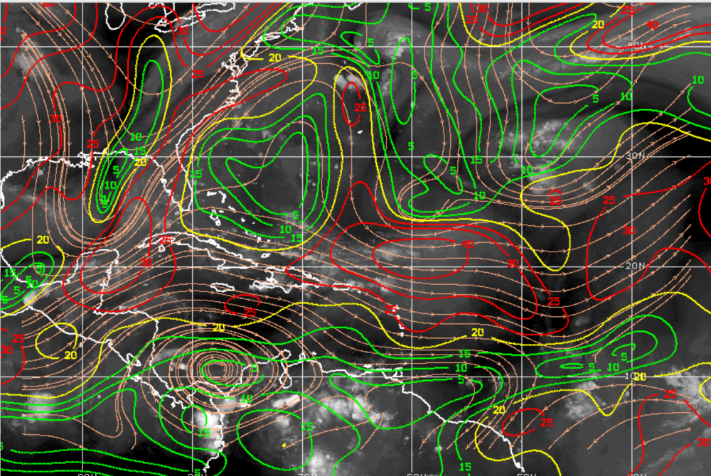
Here is the shear I was referring to. It has a narrow finger of somewhat favorable winds but is not consolidated enough to take advantage before it enters that large area of 30-40kt shear. Should it travel slightly further south, however, it may spend more time in that finger of lighter winds, affording the opportunity for some consolidation of convection
-
That strong wave that came off of Africa recently has been upgraded to 40% chance of development in 5 days. It has dry air in front of it and some hostile winds it will have to navigate but does have model support for development in the long range. The GFS, in particular, has been fairly consistent showing a moderately strong cane recurving off the SE coast in 10-11 days. I feel like this is one that may bide it's time until it gets into the vicinity of the lesser Antilles. Way far out but something to watch and probably signals the beginning of our cape verde tracking season

-
I'm in Charlotte (Huntersville) for work today and I just stepped outside and it felt, gasp, cool outside. Not sure the temp but definitely in the 60's. Almost jacket-worthy with the rain and NE breeze. RIP heatwave you have been CRUSHED!!!
-
38 minutes ago, Solak said:
0.05" yesterday.
Love watching the point forecast changes today.
After 8AM, After 2PM, after 11AM
3/4" - 1", 1" - 2", 3/4" - 1" .... all in the last 3 hours.
Meanwhile, parts of central NC are under a Flash Flood Watch. No amounts given...
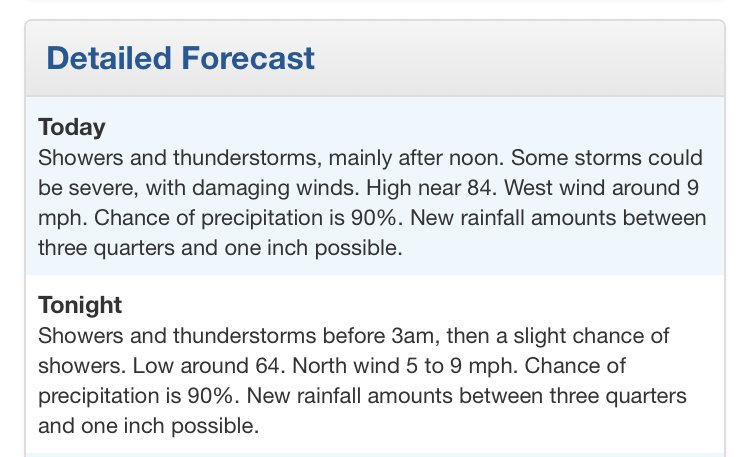
Showers and thunderstorms with very heavy rain will develop and
  spread into the northern Coastal Plain, the northeast Piedmont,
  and the Triangle area this afternoon. The showers and storms
  will become more widespread during the late afternoon and
  evening hours. The combination of high rainfall rates and the
  potential for multiple rounds of storms will result in the
  potential for flash flooding.
I noticed that too, but if you look at the point forecast and read the discussion, it seems they expect a later arrival of the rainfall and are now advertising .75-1” overnight which, combined with the daily gives us a 1.5-2” estimate which is about what they were saying earlier and about what the models look like. It is funny how the point forecasts jump around though, especially for snowfall (usually downward)
-
13 hours ago, WinstonSalemArlington said:
Major forecasted heat (air temp) bust in central NC today
I’m not sure I would call it a bust bc a fortuitous t-storm line sat over a sliver of the state. I can tell you those on all sides of that line suffered, I went to a wedding just south of it and it was 99 degrees. I am thankful that a decent portion of the most populated areas of the state got lucky though.
-
0.62” of beautiful glorious rain. Sitting at 79 with nearby anvils continuing to provide overcast. Been in the 70’s for 2 hours now in the middle of the afternoon on the hottest day of the year I’ll take it! Had to get lucky one of these days. Also brings me up over an inch for the month, lol
-
Just had a great summer thunderstorm. Still lightly raining with extremely close lighting. Going to check the rain guage after it ends but I’d say at least a half an inch. Literally getting more storms with 20% rain chances than that week of 50-70% chances. High of 92 so far but currently sitting at a rain cooled 81. When the sun comes back out help us with this added humidity!!!
-
Picked up a surprise .11" last night making 3 straight days with rain imby. Albeit small amounts but much needed. Walking out the door this morning was like walking into a wall. Really sucks the life out of you when it's like this. Can't wait for that trough to set up Early next week. Tuesday-Wednesday look awesome. Going to be a long 5 days to get there!
-
High of 96 today but got lucky with a T-storm that dropped it to 79 and has stayed in the lower 80’s since. Picked up another .20” from the storm, think areas around my neighborhood got more based on puddles. Good coverage today for only an aerial 30% chance. Hope this keeps up with some added moisture from Barry
-
Got lucky yesterday and got a heavy shower that produced a quick 0.28" which, amazingly, was my biggest total in over 4 weeks and came on a day with <30% rain chances (as compared to all the days with 40-70% that didn't pan out imby. Much needed and was pleasant afterwards as it occurred late enough to provide a nice "cool" evening!
-
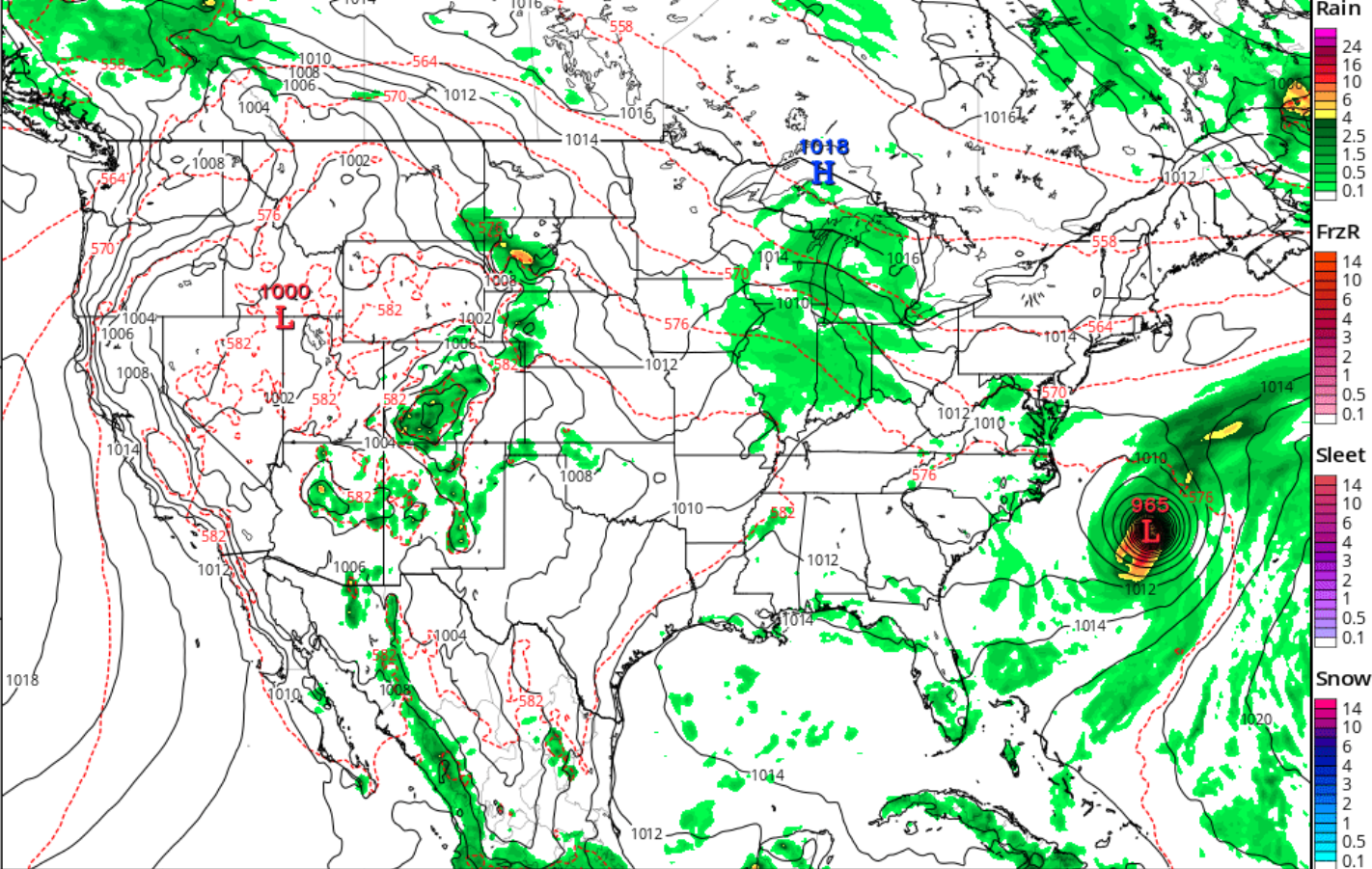
I'd like to say the media has done a good job, actually, of focusing on this as a rain threat instead of a wind one. Cat 1 or TS doesn't really matter, this thing has always been more of a threat for potential severe flooding impacts. A lot of times, it seems, these storms get brushed aside unless a major hurricane is barreling at the coast, so it's refreshing to see many media outlets taking the freshwater flooding threat seriously. Any slow moving tropical system regardless of strength moving into an already flooded region is a serious threat.
-
 2
2
-
-
High of 87 yesterday with a Low of 69 last night. First night dropping into the 60's in some time. Somewhat lower humidity too, I'll take it after the last few weeks. Looks to be short lived
-
One thing I’ve loved tracking the last few days is the pattern of these afternoon storms. With very weak steering currents they don’t really move so much as sit, rain out, then re-develop in a general direction on their own outflow boundary. Very few organized clusters but a ton of outflow boundaries makes for a busy radar but VERY inconsistent rain and the appearance of “skipping” over some places. Looks to be the case Thursday but I’ve noticed some models (gfs especially) seem to be advertising some increased coverage.
-
73/69 atm. Picked up a TR of rain with the storms last night. Petered out over my neighborhood only to blossom over downtown. Dry next couple days but models look to bring some afternoon storms back late week
-
Currently a miserable 94/75. Got fringed by the earlier storm and still no measurable rain. Hi-res models did well with main coverage area south and east of here. Hoping the boundary up north makes it here during daylight so we can squeeze something out of these 3 straight days of 60% rain chances and 0.00!
-
Morning everyone, first-time poster here! I've followed this site for years and have been a weather junkie my whole life. I grew up in the Raleigh area but attended high school in DC before going to Clemson University. I then worked in the Greensboro area for a few years before moving to Charlotte for several years and, recently, I purchased a house and am back home in Raleigh (North Hills area). In other words, I have seen a lot of our local climates and this site has been an excellent source of information for me for all weather events across the sub-forum. I have greatly enjoyed all the posters here and hope I can help contribute as well.
For a report: It got down to a "cool" 73 imby last night and is bone-dry. We have been between storms since the big one that hit the 5-points area through this "wet" period, without a single measurable rainfall (aside from a few token raindrops each day). Saw NWS backed off our chances for rain today from 70% yesterday to 40% today. Still showing 60% tonight and we need it badly. My yard looks has taken on that "mid summer" look. Hope today breaks that trend!
-
2
-
 1
1
-

2019 Tropical Weather Discussion
in Southeastern States
Posted
The "Old" GFS has it too, albeit closer to the coast. I work for Duke Energy and am part of the storm response team so, trust me, I hope everything recurves this year! It's been a whirlwind for us last few years between Matthew, Nate, Irma, Florence, and Michael! I do enjoy tracking these storms, especially Cape Verde ones. I hope it's a busy season but only with fish storms!