

NorthHillsWx
-
Posts
7,371 -
Joined
-
Last visited
Content Type
Profiles
Blogs
Forums
American Weather
Media Demo
Store
Gallery
Everything posted by NorthHillsWx
-
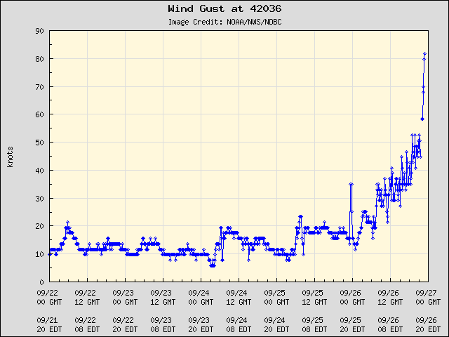
That SE quadrant is benefiting from the 30 mph forward motion to keep these strong gusts going. I expect this to continue into the upstate and mountains. Augusta is about to get rocked, fully expect hurricane force gusts there
-
Looks like the main event is underway for the mountain and upstate areas. Will only go downhill the next few hours. Good luck to everyone in those areas and be safe
-
On the main thread some current obs gusting over 100 inland still!!! Wherever that core sets up is going to get wrecked with the saturated soils ahead of it.
-
Shows what that east side is capable of. I saw that gust report on the most recent advisory from NHC and figured you were in for a wild night
-
Probably 140 mph at this point


-
Wonder if this causes enough damage in the Clemson area to alter the game Saturday night
-
That’s one of the most dire wind maps I’ve ever seen that far from a storms landfall. It doesn’t add in the 10-20” of rain that surely will result in historic tree damage if those gusts are realized. This is ones our kids will talk about on weather forums 60 years from now
-
Just indicated but major wind shift and lowering of the clouds right over our house. Rain stopped when the darkest lowering came over then picked up with probably 30 mph gusts after it passed, exact opposite direction
-
Not 0…
-
Recon more than justifies a cat 4 upgrade
-
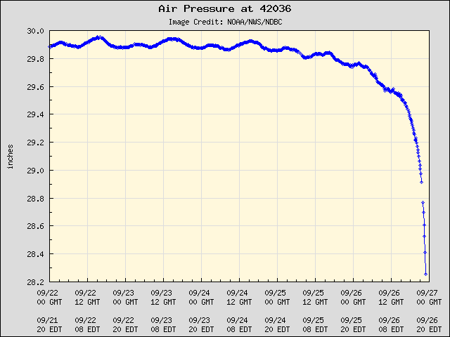
The Michael comparisons can continue. Extremely diffluent ventilation with the interaction with the trough to the north and east and movement in line with shear vector. This isn’t going to be far from Michael intensity wise in a few hours. Satellite presentations are almost identical at this stage before landfall. The dueling VHTs is a menacing look and absolutely causing these rapid pressure falls. Just wow. Those mesovortices are beautiful to watch on radar, though the destructive potential increases with every radar update
-
Here’s the rapid intensification phase… as it pulls into land. She’s a beaut on satellite
-
Thats bout as close as it gets
-
warned now
-
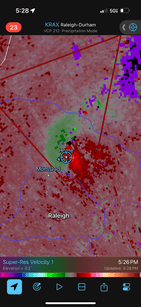
Rotation showing with cell about to move over my house
-
Not our storm in central NC but we’ve picked up about an inch of rain in 30 min with this cell. Seemingly our 30th flood advisory in the last two weeks. I’m glad at least western NC wasn’t as saturated as we are leading up to this
-
Check out the mesovortices rotating around that eyewall. IMO there isn’t a more telling sign of a storm going nuclear than seeing that.
-
Thinking about you and your family. Hoping for a positive outcome, but putting your family first is the right call here. Good luck
-
In Other bad news, this system strengthened early enough to work on maxing out the surge. Get the F away from the coast in the big bend. Hope everyone heeds that. Thankfully it’s not super populated but there’s going to be surge the likes of which that part of the coast has never seen before
-
Really thinking bout yall west of here. I cannot imagine those rainfall totals on flat ground, much less in the mountains. Then throw 50-60+ mph gusts on top of it… I don’t see a way this isn’t devastating. I try to avoid hyperbole but what’s coming is worthy of the terms devastating, historic, catastrophic, and hopefully not but extremely likely… deadly
-
A wider and much wetter version of Michael. As bad as Florida impacts will be I truly think the upstate and mountains will rival landfall zones as ground zero. A devastating storm and a historic one incoming. There’s nothing holding that back
-
I had to vent on the main board one time against people calling bust. Absolutely everything about this has been well forecast and is on schedule. These giant storms absolutely do not spin up from a TS to a Cat 3 in 18 hours like some were expecting but every time I’ve looked it looks healthier and healthier. Honestly I’m extremely impressed with the rate of intensification thus far
-
Some on here are just not in touch with reality. Everything about this storm is on track. It has been steadily organizing. Pressure has been falling, it’s eliminated that outer wind maxima and winds are responding to pressure falls. This thing has more than enough time to reach major status and I still think 110-115 kts is going to be LF intensity. These giant storms never intensify that crazy fast but it’s doing exactly like you’d expect one to do. Lots of lightning in eyewall and I expect wind to increase 5-10 kts every 6 hours until it’s on shore
-
This is going to be such a bad flood event. 11+ inches before the storm even gets there!?!? Not sure we’ve ever had a precursor event like this leading up to a significant hurricane in the mountains
-
What are y’all’s totals out west so far from the precursor event?


